The National Hurricane Center (NHC) is raising the chances for development on a Tropical Wave in the Eastern Atlantic.
Satellite View

- At the moment the wave has some clouds with showers and thunderstorms.
- It's also known as Invest 92L. "Invest" indicates an area NHC would like to investigate further, 92 is just a tracking number, and "L" stands for the Atlantic Basin.
Latest Data:
- A broad area of low pressure is now associated with the wave.
- Located: 10.5 N, 30.0 W, or a few hundred miles WSW of the Cape Verde Islands
- Winds: under 30 miles per hour
- Moving: West at around 15 mph
- Pressure: 1010 mb or 29.82"
Presently the wave is moving unimpeded over the Atlantic. There is some Saharan Dust keeping it in check but it won't last long. There are no other large scale features that could prevent its organization.
Chances for Growth
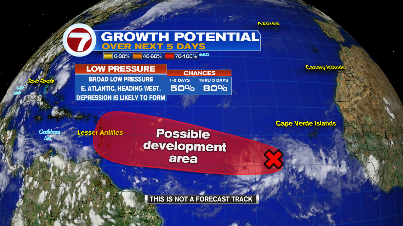
Once there, it will have a high probability, an 80% chance that it could develop over a period of 5 days.
The Lesser Antilles should monitor the progress of this wave.
Where is it headed?
I would like to caution that nothing has developed yet. Models need a good starting point in oder to give a good ending point. Right now they can only make educated guesses.
Ocean temperatures will be gradually warming as it travels west.
Warm waters over 80 degrees fuel these tropical systems' growth. Temps along its forecast path are hovering over 80.

They are presently suggesting a path that could take the system across the Leeward Islands, Puerto Rico, then possibly Dominican Republic, Haiti, and the Bahamas. South Florida could be in the mix as well.
We are moving into the most active part of hurricane season. Use this information to stay aware of what could possibly develop. Many things can happen with Mother Nature.
Timing

A handful of models hint the wave could reach 35 kt or 40 mph winds between 36 to 60 hours. That is the threshold for tropical storm status. The intensity then gradually increases thereafter with a handful of models taking it to hurricane strength in about 5 days. Intensity forecasting is very difficult and these projections are very preliminary.
What to do:
Tropical Systems vary greatly. Hanna, ramped up quickly in strength while Gonzalo, which was forecast to be the season's first hurricane, petered out. All of us who live in the Tropics should always be prepared for an impact.
Lesser Antilles- Watch the wave carefully. If it develops, you may see the system over you sometime from the middle of this upcoming week onward. Review your plans and supplies. Worry-Meter: slightly rising
Puerto Rico, Haiti & Dominican Republic- If the models are correct, you may be impacted next. Now is the time to check your supplies. While nothing has developed, it's always a good idea to be ready. Worry-Meter: slightly rising
Bahamas & South Florida- I can't stress enough that nothing has developed. Just monitor the wave. If it organizes then check on what you may need. Then follow the path of the storm to see where it may end up. Our worry meter is very low.
We'll be watching.
No comments:
Post a Comment