Tuesday, October 21, 2014

Low in Gulf may stay low

Since the weekend we've been following an area of clouds and rain int the SW Gulf of Mexico. As of early Tuesday morning , NHC is giving it a 50% chance for development during the next 5 days. Down from a high of 60% on Monday.


If it does develop it may do so along the area highlighted in orange. The other area in yellow has a minimal chance for development.

So if it develops, where is it going?
The models are all over the place. The jet stream is pushing a front South from Canada, and its coming down like a train. It should keep the system either in the SW Gulf or posh it into the Caribbean. It may also continue to weaken it. Only a couple of models re-curve the storm back towards Florida by next week.


The front that will keep this system in the Gulf/Caribbean should stall over us and keep us soggy maybe through the end of the week.


Monday, October 20, 2014

Gulf Area of Concern

As we near the end of hurricane season, systems tend to develop over the Caribbean or Gulf of Mexico more often than the Atlantic. Of course Mother Nature is trying to brew something in the Gulf of Mexico. There is an area of disturbed weather in the Bay of Campeche with plenty of cloud cover and thunderstorm activity.

This is what the National Hurricane Center is saying about this feature:

1. An area of low pressure located over the extreme southwestern
Bay of Campeche continues to produce showers and thunderstorms.

This system has some potential to become a tropical cyclone during he next two to three days while it moves slowly eastward to east-northeastward, before it interacts and possibly merges with a frontal system towards the end of the week.
* Formation chance through 48 hours...medium...30 percent.
* Formation chance through 5 days...medium...40 percent.


This is what the very early model runs are suggesting:


The models are not so sure as to where the system may end up. Some take it west , others east.  NHC place the highest chances in our direction.


The local NWS office suggest we all keep our eyes on it.

FOR THE EXTENDED FORECAST...THERE CONTINUES TO BE CONSIDERABLE
UNCERTAINTY IN THE FORECAST. HOWEVER THE GLOBAL MODELS CONTINUE TO
SUGGEST A BROAD AREA OF LOW PRESSURE ACROSS THE SOUTHERN GULF
LATER IN THE WEEK AND CONTINUE TO INDICATE AN UPPER LEVEL TROUGH
EXTENDING INTO THE EASTERN GULF...WITH THE NET EFFECT BEING DEEP
MOISTURE CONTINUING ACROSS THE REGION AND CHANCES OF SHOWERS AND
THUNDERSTORMS CONTINUING INTO FRIDAY AND POSSIBLY INTO THE
UPCOMING WEEKEND.

THE NATIONAL HURRICANE CENTER CONTINUES TO MONITOR THE AREA OF LOW
PRESSURE IN THE SOUTHWESTERN GULF AND SUGGESTS THAT GRADUAL
DEVELOPMENT OF THE SYSTEM IS POSSIBLE OVER THE COURSE OF THE NEXT
SEVERAL DAYS. SO ALL INTERESTS IN SOUTH FLORIDA SHOULD MONITOR THE
PROGRESS OF THIS SYSTEM.

Wednesday, September 17, 2014

My Moral Dilemma

I have a lengthy commute each day to and from work. I traverse both interstates and many city streets. Over the years the number of street corner folks begging for money has increased dramatically. Lord only knows what troubles and tribulations have befallen these poor people.


But now I am in a dilemma. A very good friend of mine says that I am doing more harm to these unlucky souls by giving them money.

He adds that most are drug addicts and I am just helping their habit along. He suggests the best way to help them is by not giving them money, hoping they reach rock bottom, and then seek help. 

My upbringing however taught me to help people in need. But its just getting harder and harder to differentiate between the real needy and the street corner scammers/addicts. So what do you do? Give and let live, or drive by and say good-bye?


Saturday, September 13, 2014

Wet Weekend?

On my presentations Friday, I showed 2 weather scenarios for the weekend.  We had an area of low pressure over us that at times provided for some heavy downpours. The low was kept in check due to some strong upper winds. My scenarios were based on the persistence of those strong winds.

Scenario 1: If the strong upper winds remained, it would weaken the low and the chances for rain would be fewer

Scenario 2: If the winds turned weaker then the low would have a chance to grow with a better chance for rain.

As of early Saturday morning, this is what NHC is saying about the the low:

The area of low pressure that was over Florida yesterday is now
located over the southeastern Gulf of Mexico. Shower activity
has not become any better organized, and upper-level winds are not
favorable for significant development as the system moves generally
westward during the next few days. The Air Force Reserve
Hurricane Hunter aircraft scheduled for today is likely to be
canceled. Locally heavy rains associated with the low will continue
over portions of southern Florida and the Florida Keys through
today.
* Formation chance through 48 hours...low...20 percent.
* Formation chance through 5 days...medium...30 percent.

It appears for the time being, that scenario #1 may be taking hold, but once the low pushes into the Gulf Saturday afternoon… we may see more rain returning for Sunday.

With so much uncertainty relating to this low, you can expect moments of dry weather followed by tropical downpours.

I wish I could give you a more precise outlook, but the atmosphere is so unstable that we can go from cloudy and dry to tropical rain in an instant.


In the Tropics: 
NHC is now watching only three areas. (Friday night we were watching four, but the one near Mexico has fallen apart.)

This is what NHC says:


  • Keeping tabs on the low near South Florida


  • Still following tropical storm Edouard in the middle of the Atlantic. It may reach hurricane status in a few days. It will remain a worry only for the shipping lanes.
  • Shower activity associated with a tropical wave located southwest of the Cape Verde Islands has become a little less organized this morning. Some development of this system is still possible before it moves westward or west-northwestward at around 10 mph into an area unfavorable for tropical cyclone formation.

* Formation chance through 48 hours...low...20 percent.
* Formation chance through 5 days...low...20 percent.


Friday, September 12, 2014

Better rain than a Tropical Storm

I know its soggy, damp, humid, and miserable at times but it could be worse…we could be dealing with a tropical depression or a storm.

As of Friday morning, there is an area of low pressure just South of Lake Okeechobee providing plenty of rain, but if conditions would have been just right, we could have been dealing with an angrier Mother Nature. I'll take the rain.

This is the local radar:

Most of the heavy rain is across the Keys , but by the afternoon, more is expected to develop over the Metropolitan areas of Broward and Miami-Dade.

Since the ground is saturated in some areas, street flooding is a concern.

The local NWS office has issued the following statement.


This area of low pressure has been watched by NHC for a few days.

For awhile it was sitting over the warm waters of the gulf stream current with the potential for intensification, but strong upper winds kept it in check and will keep it weak for another 2-3 days. After that, all bets are off.


Here's what NHC is thinking once the low enters the Gulf of Mexico.

Once the low moves over the southeastern Gulf of
Mexico, conditions could become a little more conducive for tropical
cyclone formation over the weekend while the system moves westward
at around 10 mph. Regardless of development, this low will continue
to bring locally heavy rains to portions of southern Florida and the
Florida Keys today and Saturday.
* Formation chance through 48 hours...low...20 percent.
* Formation chance through 5 days...medium...40 percent.

The models on this low aren't giving us a clear picture of where it may end up. You see at this stage where the low itself is poorly organized, there is no good starting point for the models to use. No good starting point = no goo ending points.

In general the models are giving s general idea. Anytime you see model runs fan out like in this case, its a good indicator they are not handling the forecasts well. There is plenty of warm water in the Gulf and it could grow rather quickly. Everyone from Mexico to North Florida should be on guard.


There is also a new feature in the Far Eastern Atlantic. This is what NHC is saying about it.

Shower activity associated with a tropical wave located south of
the Cape Verde Islands is showing some signs of organization. This
system, however, is forecast to move westward or west-northwestward
at around 10 mph toward an area unfavorable for development.
* Formation chance through 48 hours...low...20 percent.
* Formation chance through 5 days...low...20 percent.


The models, again using very sketchy initial data, keep it over open waters.


And then there is Tropical Storm "Edouard". It may reach hurricane status over the weekend, but it will remain a worry only for the shipping lanes.


Thursday, September 11, 2014

New Depression and Rain for So FLA

As of 11 am Thursday morning, NHC started issuing advisories on NEW Tropical Depression #6.
It is almost 900 miles West of the Cape Verde Islands with 35 mph winds and moving into the middle of the Atlantic Ocean.  It will slowly gain strength as it moves on a northwest track.

This is what NHS says about possible intensity:

The depression is currently in an environment of light vertical wind shear.  The large-scale models forecast some increase in southerly shear after 24 hours, which should persist through the
end of the forecast period.  

Despite the shear, the intensity guidance forecasts slow but steady strengthening.  The official forecast follows this scenario and is a blend of the SHIPS model and
the intensity consensus.


Forecast cone:

The forecast cone keeps it over open waters slowly intensifying until it reaches hurricane status in a few days.

By the middle of next week Bermuda should start paying attention in case it drifts their way.

It should only be a worry for the shipping lanes.


Florida Rain: 
Closer to home there is a disturbance just east of Florida which the National Hurricane Center is following. You can see the small area of clouds over the Northwestern Bahamas .

They are giving it a 30% chance it could develop into a depression or a tropical storm over the next few days.  It continues to move west spurred along by the Bermuda High.  Even if it doesn't develop, it is expected to cause rainy days at least through the weekend.


What can we expect?:
Most models agree that conditions for growth will remain unfavorable through the end of the week. It should cross South Florida on Friday.  Nothing is ever certain with intensity forecasting, so check back from time to time to make sure it will not surprise us.


NWS says our main impact should be rain. Some could start arriving late today and stick around through the weekend, depending on how fast it moves. We may see ponding of water on roadways  that could lead to street flooding.

The NWS office adds:
LOCALIZED FLOODING WILL REMAIN POSSIBLE FRIDAY INTO THE WEEKEND
AS A WEAK AREA OF LOW PRESSURE MOVES THROUGH FROM EAST TO WEST. IN
ADDITION TO THE RAINFALL...SCATTERED TO NUMEROUS THUNDERSTORMS
WITH FREQUENT LIGHTNING AND GUSTY WINDS WILL REMAIN POSSIBLE EACH
DAY.


Tuesday, September 9, 2014

Gaining steam

As of Tuesday morning NHC is watching one area of low pressure in the Far Eastern Atlantic. There appears to be areas of thunderstorm activity highlighted by the golds and oranges in the satellite representation.

Its chances for development have gone up an extra 10% this morning over the next 5 days. Yesterday it was holding steady at 60%, today its gaining a little steam.

This is what NHC has to say:

A broad area of low pressure located a few hundred miles south of the Cape Verde Islands continues to produce disorganized showers and
thunderstorms.  

Environmental conditions are forecast to be
conducive for gradual development of this disturbance during the next several days while it moves west-northwestward at about 15 mph.
* Formation chance through 48 hours...medium...30 percent.
* Formation chance through 5 days...high...70 percent.

The models are also shifting just a little father west, but the general consensus is that even if it develops it will remain an open water system. By the way the next name on the list is "Edouard".


Local Rain?:
South Florida may still get a soaking over the next few days due to a series of features trying to merge over Florida.  the models suggest an upper low over the Bahamas could throw some moisture our way while a weak wave over Cuba could do the same.


(Waves are very fickle they can grow quickly or fall apart just as fast.)  If the above ingredients come together we may see more rain from Wednesday through Friday.

As of early afternoon: NHC is now watching a disturbance just East of Florida.


We'll keep you posted.

Monday, September 8, 2014

One area with a good chance

Over the last few days NHC had been keeping tabs on up to three areas of possible development, as of Monday morning they are down to one. This area of clouds and rain is found very far away off the West coast of Africa.


This is what NHC is saying about this feature:
A broad area of low pressure located a few hundred miles south-southeast of the Cape Verde Islands is producing a large area
of cloudiness and disorganized thunderstorms.  

Environmental conditions are forecast to be conducive for gradual development of
this disturbance during the next several days while it moves westward or west-northwestward at about 15 mph.
* Formation chance through 48 hours...medium...30 percent.
* Formation chance through 5 days...high...60 percent.

The latest model runs suggest it should remain over the open waters of the Atlantic.


Sunday, September 7, 2014

NHC watching two, plus Rainy Tropics.

Good news, NHC was keeping tabs on three areas since Friday, but as of Sunday morning, we're down to two. But look at all the rain and clouds across the Yucatan, Central America, and the Bahamas, we're surrounded by precipitation and could see pockets of rain at any time.


Lets check out the first area NHC is following.

Its a few hundred miles west of the Cape Verde Islands.
Even though it has a small satellite signature, it does have some thunderstorm activity. If it can survive the hostile environment ahead of it, it may get a little stronger.

This is what NHC is saying:
A small area of low pressure located about 650 miles west of the Cape Verde Islands is producing disorganized showers and thunderstorms.

Environmental conditions are forecast to remain
unfavorable for significant development during the next several days while it moves west-northwestward at 10 to 15 mph.
* Formation chance through 48 hours...low...near 10 percent.
* Formation chance through 5 days...low...near 10 percent.

This area has been deemed INVEST 91, by NHC (Invest for an area they would like to INVESTigate further) The early model runs suggest whatever develops should remain over open waters. (Remember at this stage of the game with no real good info or starting point, most models are giving us a very general outlook).


The second area just recently came off the West Coast of Africa. 

NHC is thinking this feature has the better chance for organization in the days ahead.  It does appear to have more t-storm activity and at least for the time being it should shy away from drier air to the north.

Here's NHC's update:

A large area of cloudiness and disorganized thunderstorms located over the far eastern Atlantic is associated with a tropical wave that recently emerged off the west coast of Africa.

Environmental conditions are expected to be conducive for gradual development
of this disturbance during the next several days while it moves westward or west-northwestward at about 15 mph.
* Formation chance through 48 hours...medium...30 percent.
* Formation chance through 5 days...high...60 percent.


This feature is Invest 91, and here is the preliminary suite of model runs.


Here too it appears if this system develops it will be a worry only for the shipping lanes.

The third area NHC was monitoring on Friday by North Florida/Southern Georgia has degenerated into just an area of clouds and rain that will help keep most of North Florida soggy.

By the way the peak of hurricane season is the 10th of September.

Saturday, September 6, 2014

Three in the Tropics, plus a few waves

The weekend kicks off with NHC keeping tabs on three areas in the tropics. One hasn't even left the West Coast of Africa and yet, its still being monitored. The features watched stretch from the FL/GA coast to the Far Eastern Atlantic:


Lets review each starting with the one closest  to home. This is what NHC is saying:

A weak area of low pressure near the coast of Georgia continues to
produce disorganized cloudiness and showers, mainly over the
Atlantic coastal waters.  Development of this system appears
unlikely while it drifts northeastward over the southeastern United
States during the next couple of days. After that time, this
system could merge with a frontal zone over the western Atlantic
Ocean.
* Formation chance through 48 hours...low...near 0 percent.
* Formation chance through 5 days...low...10 percent.

Tropical Waves:
However, just to our South there are a couple of waves capable of sending plenty of moisture our way that could enhance our chances for rain Saturday and Sunday.

Waves are very difficult to forecast as they can grow rather quickly or fall apart just as fast. We should watch this rainy mess closely.


The second area is just off the Cape Verde Islands in the Far Eastern Atlantic. Here's the latest from NHC:

Shower activity associated with an area of low pressure a few
hundred miles west-southwest of the Cape Verde Islands has increased
and become a little better organized this morning.

However, significant development of this system is not expected due to a unfavorable dry air mass that prevails over the tropical Atlantic Ocean.
* Formation chance through 48 hours...low...10 percent.
* Formation chance through 5 days...low...10 percent.


Even though chances are minimal for growth, NHC is issuing model runs.


If it develops, it should remain as an open water system.

Now for the third and most interesting area to watch. It hasn't made it off the Coast of Africa but it has the highest chance for development.  This is what NHC says:

A tropical wave is forecast to move off of the west coast of Africa
by late Sunday. Environmental conditions are expected to be
conducive for gradual development of this system early next week
while it moves toward the west or west-northwest over the eastern
tropical Atlantic Ocean.
* Formation chance through 48 hours...low...near 0 percent.
* Formation chance through 5 days...medium...40 percent.


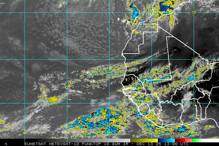
In this satellite view you can see both features, the tropical wave over Africa and the broad low near the Cape Verde Islands.

This type of activity is common for this time of year as we get close to the peak of hurricane season.

Over the last 100 years we average almost 100 named systems for the month of September. The peak arriving September 10th.

Lets hope the second part of the season will be as quiet as the first for us.


By the way, the peak of the season for South Florida comes a bit later in October. Keep those fingers crossed.

Thursday, August 28, 2014

The Tropical "Not So Fab" Four

August is the second most active hurricane month, with the peak of the season coming September 10th. At the moment NHC is still monitoring 4 areas, none of which appear to be a threat to anyone.

The latest on Hurricane Cristobal, is that its threading the needle between Bermuda and the east coast of the US.

It should only be a concern for the shipping lanes. It will however cause some strong surf and rip currents across New England and the Middle Atlantic States.


The other three areas NHC is considering are a bit less glamorous.


  • The X near Mexico is an area of disturbed weather slowly moving west. It has a minimal chance for growth. Even if it does not develop it should provide some drought relief for Northern Mexico and Southern Texas.


  • The second X in the eastern Caribbean is a Tropical Wave moving west with little promise. NHC is giving it a small chance for growth once it reaches the Yucatan Peninsula.


  • The most interesting feature is the third X over Western Africa, also an area of clouds and rain. This feature has been over land for days and remains in the cross hairs of NHC. They are giving it a moderate chance for development once it reaches the Eastern Atlantic. The area highlighted in orange is where it could become a depression or a tropical storm.


The reason why I'm watching this one more carefully is because we are in the middle of Cape Verde Season.


What is Cape Verde Season?
It is a season within the Hurricane season usually lasting from August to late September.

This is according to NASA:
Systems tend to form in the vicinity of those islands and have a reputation of making landfall in the U.S. They usually develop from tropical waves that form in the African savanna during the wet season

The average Atlantic Hurricane season brings with it approximately two Cape Verde hurricanes. These hurricanes are usually the most intense and the biggest storms of the season because they develop so far to the east and can travel over a large area of warm, open ocean waters that help power them. There are also no land forms in the way to slow tropical cyclones if they form near the Cape Verde Islands. 

Cape Verde tropical cyclones also tend to be the longest-lived storms, because of the huge area of open ocean they have to move through. Some have even moved into the Caribbean and Gulf of Mexico.

Hopefully we will stay quiet.

Wednesday, August 27, 2014

Four areas of concern. Are we ok?

A look at the enhanced colorized satellite imagery shows a great deal of cloud cover and storm activity. It is after all near the peak of hurricane season, that being September 10th.  The first thing you will notice is a big spin east of Georgia, that is hurricane "Cristobal".  It should remain as an open water system moving north. It will only be a worry for the shipping lanes.


Other Features:

  • There is also a small dot near Texas in the Gulf of Mexico, this is a weak area of low pressure that could grow quickly. A recon mission is on stand by to check it out. 
  • In the middle of the Atlantic there is another area of clouds and rain, a wave that has a small chance for development.
  • The fourth area is still over Africa.
  • All the other clouds and rain areas over the Caribbean and Central America are due to weak waves.

We know what to expect from "Cristobal", lets see what NHC is saying about the other three areas.

Low in Gulf:
Shower and thunderstorm activity associated with a weak low has increased today.

Additional development is possible before it moves inland over southern Texas and northern Mexico on Thursday.
* Formation chance through 48 hours...low...20 percent.
* Formation chance through 5 days...low...20 percent.


Here are the latest model runs on this feature.


Wave about 600 miles east of the Lesser Antilles:
Disorganized cloudiness and showers at this hour. It will move west without incident until it nears the Yucatan Peninsula where environmental conditions could become favorable for some development.
* Formation chance through 48 hours...low...near 0 percent.
* Formation chance through 5 days...low...10 percent.

Wave over the West Coast of Africa:
This is the most interesting feature. NHC believes that by the time it moves offshore into the Eastern Atlantic Ocean, conditions appear to be favorable for some development.  This is after all Cape Verde Season where most of the tropical activity forms out here. We'll be watching.
* Formation chance through 48 hours...low...near 0 percent.
* Formation chance through 5 days...medium...40 percent.

Are we ok?
As of this moment, and through the holiday weekend, we remain free of any tropical threat. But Mother Nature always has the last word so check back from time to time in case we get a curve ball thrown at us.

Tuesday, August 26, 2014

Tropical Trouble

September is the most active month for tropical activity,  peaking on September 10th, but August comes in right behind in second place.

As of Tuesday morning NHC is monitoring four areas in the Atlantic basin. We begin with "Cristobal". As of early morning it was a minimal hurricane with 75 mph winds heading NE.

This is not a good looking system. It lacks the typical symmetrical look of a healthy storm.

The western side is still rain and cloud free while most of the rain and gusty winds remain to the east.

Recon planes still show hurricane force winds and most models are forecasting some strengthening.

There is plenty of rain associated with north/south slant of "Cristobal". Some of that rain is still impacting the Southeastern Bahamas, Hispaniola, and Eastern Cuba.

It should by pass Bermuda and remain as a worry only for the shipping lanes.


"Cristobal" will generate some high swells across the Atlantic waters making it rough for mariners.

These waves will also bring along the threat of rip currents up and down the US Coast.

Boaters and swimmers are asked to take extra care when venturing into the Atlantic waters over the next 48 hours, until the threat subsides.

By the weekend it should arrive in the cold waters of the Northern Atlantic otherwise known as the hurricane graveyard.


Aside from "Cristobal", there are three other features worth mentioning. We'll begin with the area in the Gulf of Mexico.

1) This is an area of clouds and rain, not too significant, but it is sitting over very warm waters that could allow it to grow. For the moment atmospheric conditions are not favorable for development so NHC is giving it only a 10% chance for growth over 5 days.


2) The x in the middle of the Atlantic is about 900 miles east of the Lesser Antilles. It has some showers and thunderstorms. It had a better chance for growth on Monday, but as of today, environmental conditions are not expected to be favorable for significant development. That could change in a few days. NHC is giving it 20% chance for development through 5 days. If it does organize it may do so over the area marked in yellow.


3)  The third area monitored hasn't even emerged from the West Coast of Africa, but NHC thinks it has the potential for organization. They say a tropical wave is forecast to move off the west coast of Africa
late this week, and conditions appear to be favorable for some development thereafter. NHC is giving it a 30% chance for growth. If it develops, it could do so over the area highlighted in orange.


Stay tuned.

Monday, August 25, 2014

Kris-to-bal , Kris-TOE-bal What gives?

I have received hundreds of e-mails and countless texts complaining about our pronunciation of Tropical Storm Cristobal. They suggest, claim, accuse me of giving it a Latin spin. Let me explain how it works:

The World Meteorological Organization is in charge of coming up with the names for storms. A special  Hurricane Committee determines a pre-designated list of hurricane names six years in advance. The names are suggested by Meteorological and Hydrological Services from North/Central America and the Caribbean.

As you can imagine, the names suggested cover the languages spoken throughout the entire Atlantic basin, English, Spanish, French, and Dutch.  This is why you may get a name like "Andrew"- English, Georges-French, Cristobal-Spanish , Van -  Dutch.

These names are NOT chosen after any particular person. 

When I worked at Telemundo years ago, we did not pronounce "Andrew" as "Andres"... we used the correct English terminology, and thus we do the same today with Cristobal.

Here is the link for all the names and their pronunciations for the next 6 years.
Hurricane names

Sunday, August 24, 2014

Tropical Storm Cristobal

Where is it?
Tropical Storm Cristobal is spinning very close to Mayaguana Island in the Bahamas, or roughly 500 miles southeast of South Florida. It will start moving NW over the next 24 hours at a very slow pace.
Tropical storm force winds extend outward from the center about 140 miles with most of that being felt to the northeast of the system and mainly over open waters.

At the moment:
"Cristobal" organized some overnight with more rain developing within its feeder bands, but the winds have not picked up any. As of this writing they remain around 45 mph.

Looking at the color enhanced satellite imagery , with the golds and reds showing the heaviest of the rain, the strongest downpours are impacting the Turks and Caicos islands.

Most of the heavy rain is over open waters. Clear skies dominate the Central and Northwestern Bahamas, but by Monday this area will start feeling the effects of "Cristobal"

The following statement is from NHC: 

RAINFALL...CRISTOBAL IS EXPECTED TO PRODUCE RAINFALL TOTALS OF 4 TO 8 INCHES OVER THE SOUTHEASTERN BAHAMAS...THE TURKS AND
CAICOS ISLANDS...AND THE CENTRAL BAHAMAS THROUGH TUESDAY.

ISOLATED AMOUNTS AROUND 12 INCHES POSSIBLE. STORM TOTAL RAINFALL AMOUNTS OF UP TO 12 INCHES ARE POSSIBLE IN PORTIONS OF HISPANIOLA...WHERE THESE RAINS COULD PRODUCE LIFE-THREATENING FLASH FLOODS AND MUDSLIDES...ESPECIALLY IN AREAS OF MOUNTAINOUS TERRAIN.

What is next?
Most models show "Cristobal" slowing down and dumping plenty of rain across the Bahamas. It should wobble a bit more to the northwest through Monday before running into some very strong upper level winds.

These strong winds will be coming off the Eastern Seaboard on Tuesday helping to push  "Cristobal" away from most land areas.  By Thursday however, those winds weaken just enough for "Cristobal: to swing closer to the US, but still remaining offshore.

If it should reach hurricane strength , it may do so east of the Carolinas. It should steer clear of Florida altogether.

This is the latest from NHC regarding the cone:
The track has been shifted eastward, but it remains along the western side of the
guidance envelope out of respect for the ECMWF and continuity of the previous forecasts.The new track forecast is closest to the HWRF, but is well west of the latest multi-model consensus.  

Future eastward adjustments may be required if the eastward model trend continues.  Given that a large spread remains in the guidance, the confidence in the track forecast remains lower than normal.

The means, the cone could shift a bit more west or east over the next 24 hours, but in general, the system should remain a few hundred miles away from us.

South Florida Impacts?:
Most of what we will see from "Cristobal" depends on how strong it gets as it slides away to our east. We are looking at mostly rough marine conditions with large swells developing by Monday and Tuesday. Tuesday maybe the closest approach to our area with the possibility of a few stray storms across South Florida.  More storms may linger until Friday.

Boaters and surfers:
Should really pay attention to "Cristobal" . If you plan on boating beyond Biscayne Bay and over offshore coastal waters, navigation could be a little rough. There is a chance for strong winds and higher seas the further east you travel.

Bottom line:
The Southeastern and Central Bahamas should see squally weather over the next 24-48 hours. South Florida may get a downpour or two over the next few days with no direct impact. Then the Mid Atlantic states could see rough surf and a few t-storms depending on how close "Cristobal" gets.
And remember as much as we value models and forecast outputs, Mother Nature always has the last word. Check in from time to time for updates.