Here's a quick look at a few events happening in Space News:
Sun Burped:
A hole in the shape of a canyon has opened up in the sun's atmosphere. This is blowing off solar wind and aiming it towards earth. This solar wind could arrive early Tuesday, Feb. 28th, sparking a northern lights display, Forecasters at NOAA, say there is a 60% chance of G-1 storms thru March 1st. This may cause some satellite and cell phone outages.
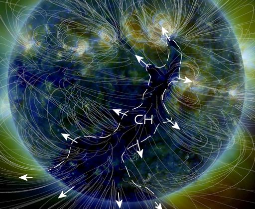
The source of the solar wind is a coronal hole (CH)--a region in the sun's atmosphere where the magnetic field opens up and allows solar wind to escape. NASA's Solar Dynamics Observatory photographed the structure, above, on Feb. 27th.
Researchers call this a "negative-polarity" coronal hole because it contains south-pointing (that is, "negative") magnetic fields that tend to be very effective in causing geomagnetic storms when they reach Earth. Arctic sky watchers should be alert for bright auroras in the nights ahead
Side by Side:
After sunset Monday, look west and you'll see a skinny crescent moon. It will appear near Venus giving you a great 2 for the price of one viewing.

And finally, if you have the cash....
 Private space firm "Space X" is planning on flying 2 people around the moon in 2018. Allegedly these two folks have provided a significant down payment already for the mission. SpaceX says, they'll "begin initial training later this year".
Apparently, other people, have expressed strong interest and we expect more to follow. Additional information will be released about the flight teams, contingent upon their approval and confirmation of the health and fitness test results.
Space X adds, "This presents an opportunity for humans to return to deep space for the first time in 45 years and they will travel faster and further into the Solar System than any before them"
.