Saturday, July 7, 2018

"Beryl" Downgraded

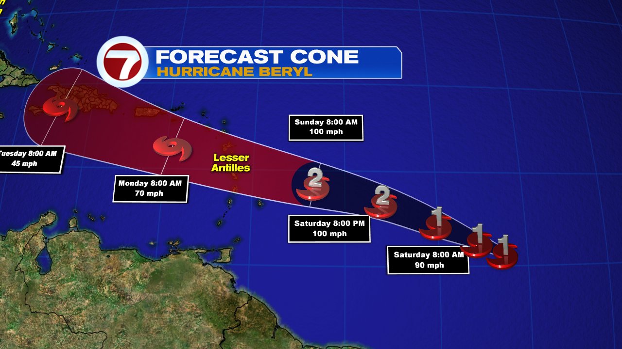
This weekend will determine how strong/weak "Beryl" may be before in reaches the Lesser Antilles.
Throughout its duration it has been a little storm with big ambitions. It triumphed over dry air and Saharan dust to its north to reach hurricane status. Now it appears there is a bully in the road, and that is in the form of wind shear.


I mentioned yesterday that the entire cloud mass of "Beryl" could fit between Miami and Orlando with the dangerous hurricane winds covering only a 10 mile area. Its small eye made it vulnerable  to disruptions.  As of Saturday, the disruption appears to be happening as it no longer has hurricane force winds.


On the black & white satellite picture, you can see the comma shaped cloud mass almost in the middle of the screen, this is "Beryl". On closer inspection, the imagery suggests the eye is cloud free and now exposed to the elements. 

There is some sheen on the picture to the west, north and east of "Beryl", this is Saharan dust. This dry air appears to finally be taking a toll with most of the rain sitting to the southeast of the center. This is not a good sign, as it needs plenty of  moisture around the eye to keep it going.  

The morning observations allowed the National Hurricane Center (NHC), to downgrade "Beryl" to Tropical Storm status. Conditions appear unfavorable that it can regain hurricane strength.

If the exposed center isn't enough to weaken it, there is a larger weather phenomena in it's path that should provide, if not a knock out punch, at least a standing 8 count.


Right over the Lesser Antilles there is strong shear waiting for "Beryl". These very strong upper level winds should cut down the system as it enters the Caribbean Sea. Some models call for "Beryl" to be just a tropical wave in about three days.  Most models keep whatever is alive after the shear, either over Jamaica or the Bahamas.  No need to be on alert in these areas, just keep an eye out in case it throws us a curve ball. 

Where is it headed?


The steering winds will keep "Beryl" in a northwesterly path throughout it's life cycle. Even if it's just a storm as it approaches the Central Lesser Antilles, it is still capable of some rain and gusty winds.

  • The government of Barbados issued a Tropical Storm warning for Dominica. The Hurricane watch has been cancelled.
  • The government of the Netherlands issued a Tropical Storm Watch for Saba & St. Eustatius.
  • Tropical Storm watches still in place for Barbados, St. Lucia, Martinique, Guadeloupe, & St. Martin


What can the islands expect?

Since "Beryl" is very small, the consequences of its arrival are not that clear, but NHC says:

  • Tropical Storm force winds of 39+ mph, should speed over Dominica, and other islands under advisories, on Sunday night .

  • The storm could drop as much 4 inches of rain across the Lesser Antilles. Very difficult to say exactly where because of its small size. Puerto Rico and the Virgin Islands could get between 1 - 2 inches. Some localized flooding is possible.

More tropical activity
Tropical Depression #3 is sitting offshore the Carolinas, and even though it's expected to get stronger over the next few days, it should remain away from land.

We'll keep you posted.


Friday, July 6, 2018

Beryl aims for the Islands & a new depression is born

Two to watch into the weekend. Hurricane "Beryl" in the Mid Atlantic Ocean and tropical depression #3 just off the Carolinas. Recon missions have been scheduled for both on Saturday.


Hurricane "Beryl" is an extremely small system. Its cloud cover could safely fit between Miami & Orlando. The dangerous hurricane force winds are only in an area 10 miles wide, almost the same distance between Miami Beach and Miami International Airport.


These are the latest numbers as of 11 pm Friday night.  "Beryl", has been lucky so far due to high pressure sitting over it allowing warm moist air to rise and create thunderstorms. Even with dry Saharan air to its north, it is managing to thrive. But look at that spike of cloud cover coming out of the south over the islands, that is shear. These are strong upper winds that can shred a storm apart. It will be interesting to see what will happen to "Beryl" once it runs into that.
  
Where is it going?


The official cone from the National Hurricane Center (NHC), suggests it may impact the islands over the weekend as a category 1 system. When Hurricanes are this small it's very difficult to really get a good handle on strength. Everyone across the islands, should keep an eye out on this one.

New Depression


As of Friday afternoon, NHC, began tracking tropical depression #3. This one should remain weak for another day or two, spinning off shore for awhile. It will be trapped by a front to the west and high pressure to the east. It should become a tropical storm over the weekend and if it does, it will be called "Chris". It may eventually become a hurricane by next week.

Where is this one heading?


Eventually the cold front should lift the system and push it northeast, hoping that on this track it impacts no land areas.

We'll be updating as needed.

"Beryl" - The first hurricane of 2018

As of 11 am Friday, the small, unimpressive tropical storm "Beryl" has reached hurricane intensity. With all the models suggesting it was in an area not favorable for such growth or that an air wall was ahead in its path set to mow it down... "Beryl" has defied the odds and grew in strength.


On the satellite image which spans night and day, the storm is seen in the lower right hand corner. Notice during the day imagery, how there is a brownish color above the storm, that is Saharan dust. Typically this helps to keep systems in check, but it is not bothering "Beryl" too much.

The system is very small and compact with hurricane force winds of 74 mph+ extending outward from the center only 10 miles and tropical storm force winds of 39 mph+ reaching out about 35 miles. Looking back, Tropical Storm Marco from 2008 just had gale force winds, around 30 mph, that spanned out only 12 miles from center. 

The steering winds remain the same pushing the hurricane west and aiming for the Lesser Antilles. Everyone there should be getting prepared. As of this morning, it is not expected to weaken as it moves over the islands sometime this weekend. Even if it doesn't grow in size, it could still pack a mighty punch.

I said on air Thursday, that "Beryl" is "the little storm that can", and it appears it will. The reason for "Beryl's" bravado, is high pressure sitting above it. This allows warm, moist air to rise giving birth to new thunderstorms inside the storm.


Where is it going?


Normally when a system picks up some forward speed, as should happen in the next few days, it keeps storms from intensifying too much. This may happen. There is also some shear, or strong upper level winds by the islands, that act as a blade cutting the system down. The question is, will they have a huge impact on "Beryl". NHC says that this system will keep it's hurricane force winds past the Lesser Antilles by Sunday or Monday and it could be near Puerto Rico, Dominican Republic, and Haiti on the following day.

Because "Beryl" is so small trying to forecast exactly what impacts may be seen where, is difficult. It's diminutive size is also a concern to forecast intensity. It can grow quickly or weaken just as fast. Storm watches and warnings may be issued by tonight.

I'll keep you posted.


Thursday, July 5, 2018

Beryl set to become a hurricane on Friday

As of late Thursday night, the National Hurricane Center was following two systems in the Atlantic. An area of low pressure close to Bermuda, and Tropical Storm Beryl in the Mid-Atlantic Ocean.


 "Beryl" was a mere tropical wave two days ago, becoming a depression Thursday at 11 am, and then turning in to a storm by 2:30 pm. Since then, its been gaining strength with winds around 65 mph. It is aiming for the Lesser Antilles and could arrive there by the weekend.

 
  According to Colorado State University, Tropical Storm "Beryl", is the furthest southeast a named storm has formed this early in the season. Even with dry air surrounding it and Saharan dust to the north, its been able to tap into moisture from its south with just enough energy to allow it to intensify.
 

Where is it headed?


The official forecast cone from NHC, has Beryl, becoming a category one system on Friday. High pressure to the north along with the trade winds to the south will propel the system west towards the islands.
 

 "Beryl" is expected to hit a wall as it nears the Lesser Antilles in the form of shear. These are very strong upper level winds that help cut down tropical storms. If "Beryl" reaches category one status, it should weaken to tropical storm status, maybe even weaker. This still means gusty winds and rain, so DO NOT let your guard down across the Lesser Antilles.

 How far from South Florida?


This tropical storm is over 2000 miles from South Florida and is no concern for us.

 Another area to watch
 

There is another system NHC is looking into, and that is Invest 96L.  This is an area NHC would like to INVEST-igate further, 96 is a tracking number, and "L" stands for the Atlantic Basin.  It has a 50% chance for development over 5 days in the area highlighted.


If it does organize, it will get trapped near the coast by high pressure to the east and a front coming out of the nation's mid section.

We'll keep you updated

Wednesday, July 4, 2018

Two to Watch in the Tropics

The National Hurricane Center is following two areas in the Atlantic for the possibility of development. The first is closer to the U.S., with the second farther away in the Mid Atlantic Ocean.


Area #1, Disturbance East of Florida


At one time this area of clouds and rain had a 60% chance to become something stronger, such as a depression or a named system, but as of 8 pm Wednesday night, the potential for development came down to 50%. If it were to organize, it could do it over the next 5 days inside the area highlighted in orange. 
If it did grow, a front coming out the nation's midsection would push it away from the states.

Area # 2 Vigorous Low in Mid Atlantic


Low pressure is spinning about 1000 miles west-southwest of the Cape Verde Islands. It is moving quickly at around 15 - 20 miles per hour. It was nothing more than a weak tropical wave a mere 24 hours ago, and since then, it has become an area of low pressure with a very high chance for development. It is quickly getting its act together even though there are a few obstacles in front of it.

If it were to develop, where will it go?


The very early model runs suggest high pressure to the north and the trade winds to the south will push the Low  west-northwest over the next 5 days. It has a good chance of becoming a depression or even a tropical storm as it continues to develop more thunderstorm activity.


Features working against the Low
Number 1: Shear


In this graphic you can see both, where the models place the system, and where "Shear" can be found.  "Shear" are very strong winds high up in the atmosphere that help cut down tropical systems.  By Monday, the brownish colors, represent strong winds or very unfavorable areas for the Low to travel through. It may weaken back to a wave or erased completely.

Number 2: Saharan Dust
 

By now you know huge wind storms over the Sahara desert spew dust into the Upper Levels of the Atmosphere. This Saharan Dust is very dry and keeps tropical systems from growing or developing at all. There is plenty of this dust to the north and west of the low, and yet it's managing to form plenty of thunderstorms.

What's working for it?


Warm water. Sea surface temps of 80° and above is what helps these tropical engines run. The Low is straddling the edge of the warmer waters of the Atlantic and it appears it may do so until it reaches the Lesser Antilles.


For you across the Islands, remain vigilant. Even though the Low is expected to weaken as it nears you, Mother Nature can always change her mind.  I'll keep you posted.

Tuesday, July 3, 2018

From South Florida to the Tropics, Mother Nature's Fireworks

The next few days will be interesting indeed as rain may pop up on the 4th, and the National Hurricane Center is looking at a couple of disturbances.


Lets begin with the possibility of Mother Nature delivering her own fireworks on the 4th. On the satellite image above you will notice a ring of clouds east of Florida, this is a low pressure system. It's not your typical run of the mill low near the surface, but an upper low in the mid to upper levels of the atmosphere.


This low will continue to move west and should push in some moisture across South Florida. As of 10 pm Monday night, that model run suggested downpours starting around midday.


The same model run suggests that the rain should all have moved west or fallen apart completely, just in time for the fireworks displays. We are hoping it is correct!

 In the Tropics


The National Hurricane Center (NHC) is watching a couple of features that promise some organization in the days ahead. We begin with possible activity in the Western Atlantic. 
NHC says a disturbance East of the Carolinas, has a 50% chance of  becoming a depression or a tropical storm somewhere in the area highlighted in orange over 5 days. The good news is, a front streaming out on the Upper Midwest should reach the coast in time to keep the disturbance offshore and away from land.


The second area being monitored is an aggressive tropical wave close to the Cape Verde Islands in the Far Eastern Atlantic.  It is battling dry air to the north but it may have enough moisture seeping from the south that could keep it going.

 
NHC is giving the wave a 20% chance for organization in the area highlighted in yellow thru 5 days.


Saharan Dust
The dust is thrown into the atmosphere by strong storms over the Sahara desert. It is carried across the ocean by strong upper level winds and can be a limiting factor to storm formation. In the image above you can see the dust as a fine, almost "milky-looking", shine that extends from the west coast of Africa across the Mid Atlantic and into the Caribbean.  If the tropical wave is going to grow, its going to have to survive this moisture starving atmospheric feature.

We'll keep monitoring. Have a safe 4th of July!!!