Friday, July 31, 2020

Isias May Get Stronger

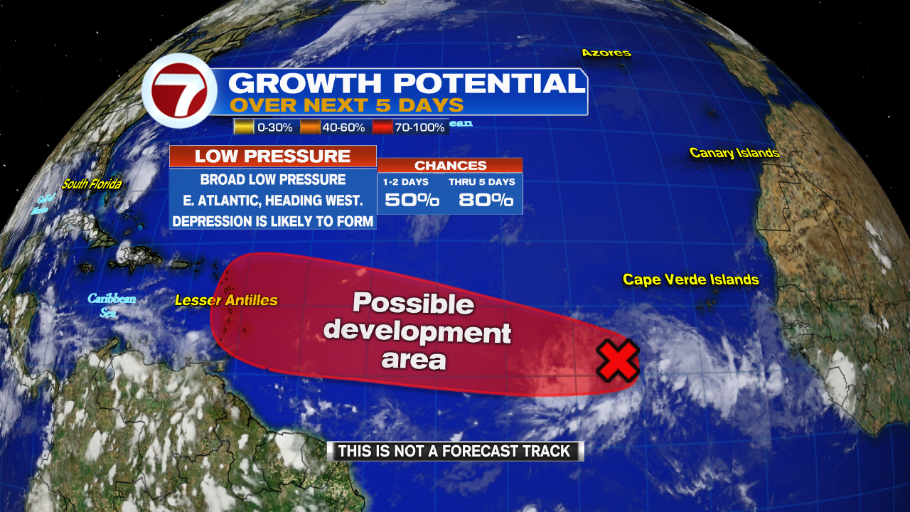
Nothing should prevent Hurricane Isaias from getting stronger. If nothing changes on its present course, it will be a huge rainmaker with winds well over 80-90 mph plus. Unfortunately it will travel across all of the Bahamas in the next few days. We are sending nothing but good vibes to our neighbors to east.


Here's the latest: 
  • It's possible it can get stronger. Plenty of warm waters with nothing in the atmosphere to weaken it through the weekend. Shear, or strong upper winds that can impact it may not arrive in time. Some dry air weakened it slightly Friday mid morning but it may not last long.
  • Heavy Rain: Still lingering over Dominican Republic and Haiti with strong winds, the same for the Turks and Caicos and parts of the SE & Central Bahamas. The National Hurricane Center (NHC) says, these downpours have the potential for LIFE THREATENING flooding. Please be alert and ready to move if asked. Heed the advice of local authorities.  Haiti: An additional 4 - 8 inches is forecast, 12 in spots. Turks & Caicos & Bahamas: 4 - 8 inches
  • Strong Winds: Should be felt across much of the Turks & Caicos this morning. Hurricane force winds will move over SE & Central Bahamas today and NW Bahamas on Saturday. All of the region should have finished their preps. Dangerous storm surge will accompany Isaias.
  • Eastern Cuba is looking at on and off gusty tropical storm force winds with up to 1 - 2 inches of rain.
 

South Florida In the Cone

  • We are now in the cone of concern. A reminder, the cone only shows where NHC thinks the center or the eye of Isaias may be. 
NEW WATCHES AND WARNINGS FOR SOUTH FLORIDA


Broward County is now in the Cone of Concern. 
  • A Tropical Storm Warning is now in place for our area from Ocean Reef north to Sebastian Inlet. This means we can expect winds over 40 mph. The wind field of Isaias is huge. Hurricane force winds over 74 mph extend out from center to 35 miles, and tropical storm force winds over 39 mph per hour fan out from center, 205 miles. 
  • Hurricane Watch issued from Deerfield Beach North to Volusia-Brevard Co. Line.
  • So Florida is also under a Tropical Storm Watch, which means we could see winds over 39 mph starting sometime Saturday afternoon. 
  • If the models hint of any westward shift, additional Watches and Warnings may be issued later today.

What to Expect:
  • If nothing changes with the current model runs, the center or eye of the storm should unfortunately be over the Bahamas. A REMINDER, hurricanes do not travel in a straight line, they wobble, and if it wobbles west as it nears us, we could see worse conditions.
  • Wind: Most likely will remain around 25 to 35 mph, with the possibility of tropical storm force. We could see those stronger winds arriving Saturday afternoon and subsiding Sunday. 
  • Marine: High Surf and dangerous rip currents are likely. On the water, conditions will deteriorate Saturday morning. May improve late on Sunday depending how quickly Isaias can depart.
  • Rain: Should start to move in late tonight early Saturday. The National Hurricane Center suggests anywhere between 2 - 4 inches. This will largely depend on how close the eye nears us. 
Bottom line: BE ALERT. If models keep shifting westward, any additional wobble in the storm and we could be dealing with a direct impact. I cannot stress this enough. BE ALERT.

Because the eye of the storm may be close, NHC is thinking of adding a Storm Surge watch for the coast. 

We'll be watching


Thursday, July 30, 2020

Tropical Storm Isaias

The National Hurricane Center is Tracking Tropical storm Isaias in the Caribbean Sea. This system was upgraded from Potential Storm #9 late Wednesday Night. After its impact with Dominican Republic, Haiti and Puerto Rico, its path will bring to the Bahamas and South Florida.


Isaias is a large storm. Winds of 40 TO 60 miles per hour fan out from the center up to 415 miles. It should impact Puerto Rico, Dominican Republic, Haiti, Virgin Islands, Turks & Caicos, and SE Bahamas today with heavy rain that can lead to life threatening flash flooding, land and mudslides. Gusty winds will be spread out through the region.

What to Expect


Isaias will move through the Virgin Islands and Puerto Rico and then cross into Dominican Republic today. How much of a disruption this will have on Isaias is still unknown. It may come out a much weaker system once in the Atlantic Waters. Nonetheless, heavy rain and gusty winds should spread into the Turks & Caicos and SE Bahamas later today.

What Next?
  • Models suggest a more disorganized Isaias after its impact with Dominican Republic. The key will be where does the center emerge once in the Atlantic. A more Easterly placement and it could have more of a NW Bahamas heading. If on the other hand it emerges more westerly then a more South Florida route could be in the works. This uncertainty is reflected in the cone, with a slight shift to the east as of 8 am. That may change in either a west or east direction once in the Atlantic.

This placement will also play a role in determining how strong it will be after its clash with Dominican Republic. If it slows down, it may be able to soak up much needed fuel in the form of hot water. That could give it a chance to strengthen.

  • For South Florida we are looking at the possibility of a stronger system leaning more to the East, or a weaker system leaning more over us. Either way, this is a huge storm in size. Impacts will be felt hundreds of miles away from the center. We may see advisories issued for South Florida later today.

Recon is scheduled for today that will give the Hurricane Center a better idea of Isaias' health and its surrounding.


We'll be watching


Wednesday, July 29, 2020

Disorganized #9

Satellite imagery shows Potential Tropical Storm 9 (PTS9) looking ragged, yet holding its own.


The system remains elongated and tilted in a SSW to NNE angle. The challenge this Wednesday will be for Hurricane Hunters to find the elusive center of circulation so a proper forecast cone can be issued.

More rain and thunderstorms are developing which is one indicator PTS9, could become a full tropical storm by the name of Isaias.

Latest Data:
  • The broad circulation is now in the Eastern Caribbean Sea. 
  • Feeder bands extend from the Leeward Islands to the North Coast of Venezuela 
  • Winds have picked up from 40 to 45 mph. 
  • Heavy rain persists across the Leeward Islands
Forecast Cone


Due to the fact there is no organized center of circulation, it is very difficult for models to give an accurate forecast cone. Shown here from NHC, is a highly probable track. Until there's a good fix on the center, the cone will remain uncertain, specially in days 3 thru 5.  South Florida, Cuba,  and the Bahamas should monitor closely. Many things can change in the next 24-48 hrs. with the cone.

Track Thinking
  • High pressure remains the driving force in pushing the system west.  It will remain in place through Thursday.This will place PTS9 near Puerto Rico and Hispaniola.  
  • The system nay get a little stronger before it moves over Dominican Republic and Haiti.  
  • The high terrain of Hispaniola will have an impact on the system, weakening its structure. 
  • The high will then retreat late Thurs/early Fri. opening the door for the system to make a northwest turn. PTS9 will also slow down its forward speed. 
As it travels into the Florida Straits PTS9 will contend with 2 features; Warmer Water & Strong upper levels winds known as shear. The shear could keep it weak while at the same time, the warmer waters could give it some fuel to grow.

Even if it doesn't get any stronger, PTS9 will be a big rain maker.  

The forecast calls for:
  1. Leeward Islands & Virgin Islands: 3" - 6"
  2. Puerto Rico: 3" - 6" with up to 10 in spots
  3. Dominican Republic, parts of Haiti, Turks & Caicos: 3" - 6" with some areas as much as 10"
  4. Inagua Islands: 4" - 8" up to 12" in spots
  5. Windward Islands: 1" - 3"
All this rain will lead to flooding, land and mudslides in many areas. Heed the advice of your local officials.

Until a center can be found., the forecast is dubious. The track can shift depending on where the center is actually found, strong upper winds impacting the system, and how fast it's moving. For South Florida and the Bahamas, prepare for the possibility of pockets of heavy rain and tropical storm force winds over the weekend. Be prepared for changes to the forecast as new data comes in. This is a great reminder we should be prepared for whatever Mother Nature sends our way.

We'll be watching


Florida in the Cone

A big tropical mess is moving over the Caribbean Islands and it may eventually travel to South Florida.


This spin of clouds and rain is known as Potential Storm 9. There is a spin in this feature but the actual low pressure center has been elusive. 

Hurricane Hunters could not find it on Tuesday. They will try again on Wednesday. 

If it can be found, it will be classified as a Tropical Storm and be called Isaias. 


Health Status

A few things are working against this system. There is dry air to the north with some Saharan Dust. Also strong upper level winds known as Shear are helping to keep it in check and of course land interaction. Still, it seems to hang on.

The Forecast Cone


The track will be a bit challenging. Models base their forecasts on a good starting fix. Because there's no closed center of circulation, the cone and intensity forecasts will remain iffy until the center is found.

We know the system will move over the Leeward Islands early on Wednesday with heavy rain and gusty winds.Then travel over the Virgin Islands and Puerto Rico Wednesday evening. It could reach Dominican Republic and Haiti the next day. Cuba will get the rain and wind by Friday.

In the long run, it may even reach South Florida and the Bahamas. All that may change if the center is found in a different location than presently estimated. The system will be pushed NW by high pressure and will look for the gap between the high and the approaching jet stream as its route north.

Hazards

Rain will be the biggest concern. Large amounts will lead to a flooding threat along with land and mudslides.

The forecast calls for:
  1. Leeward Islands & Virgin Islands: 3" - 6"
  2. Puerto Rico: 3" - 6" with up to 10 in spots
  3. Dominican Republic: 3" - 6" with some areas as much as 8"
  4. Haiti: 2" - 4"
  5. Windward Islands: 1" - 3"

South Florida and the Bahamas should monitor closely. Many things can change in the next 24-48 hrs. with the forecast track.

We'll be watching 


Tuesday, July 28, 2020

So FL in the Cone

The National Hurricane Center (NHC) is issuing advisories on NEW Potential Storm 9.


Stats: 
  • Winds: 40 mph. They extend out from the center of circulation up to 230 miles.
  • Located: Just under 600 miles ESE of the Leeward Islands
  • Moving W rather fast at 23 mph
  • Clouds from PS 9 already moving across the Windward Islands

Tropical Storm Warnings now in Place:
* Puerto Rico, Vieques, Culebra
* U.S. Virgin Islands
* British Virgin Islands
* Antigua, Barbuda, Montserrat, St. Kitts, and Nevis
* Guadeloupe, Martinique, and St. Martin
* Saba and St. Eustatius
* St. Maartin
A Tropical Storm Warning means that tropical storm conditions are expected somewhere within the warning area within 36 hours.

What is a Potential Storm?
This is a term used by NHC that allows them to start issuing advisories even before an actual system is classified. It affords residents in the path of the developing system a chance to get advance notice to prepare.

If Potential Tropical Storm 9 intensifies, it will be called Isaias. That is Spanish for Isaiah.

Present Concerns:
Potential Storm 9 can dump heavy rain. Forecasts call for 3 - 6 inches with some spots up to 10" across the Northern Leeward Islands, Virgin Islands, and Puerto Rico in the upcoming days. That could lead to flooding, land and mudslides.

Wind will also be an issue. Forty plus, mile per hour winds will be possible over the same area from Wednesday through Thursday. 

Cone of Concern


Models suggest this system should become Tropical Storm Isaias as early as Tuesday Night. High pressure steers it in a northwesterly direction across the Leeward Islands, Puerto Rico, Dominican Republic, all of the Bahamas and eventually South Florida. 

The issue with the cone and the intensity is that the system does not have a well organized center. If that center develops a bit further north or south of its present location it will change the forecast track.

Worry meter is elevated for the islands under the watches.
The Bahamas and south Florida. Now is the time to review your plans and supplies. There is still a lot of uncertainty with this system as it may fluctuate in strength and track. You should review review your needs and be prepared to act if advisories are issued for us.

We'll be watching


Advisories to begin

The National Hurricane center (NHC) will start advisories on Potential Tropical Storm 9, at 11 am. Some of the Islands in the Lesser Antilles have issued  their own Weather Alerts Tuesday morning due to Invest 92L


Satellite Loop

Stats:
Location 14.0 N, 50.0 W or just over 400 miles East of the Windward Islands.

Moving: West at 15 - 20 mph

Winds: A NOAA buoy near the Islands reported winds near Tropical Storm Force (39 mph) 


From the Antigua and Barbuda Meteorological office:
A Tropical Cyclone Alert is in place for the Leeward Islands and British Virgin Islands. 
Even though 92 L has not formed into a depression or a storm, it is capable of heavy rain and gusty winds starting on Wednesday for you.

The say:
IT IS DIFFICULT TO DETERMINE THE IMPACTS, AT THIS TIME. NOTWITHSTANDING, AL92 IS FORECAST TO BE IN THE VICINITY IN THE NEXT TWO DAYS AS, AT LEAST, A TROPICAL CYCLONE. 

LOCALLY HEAVY RAINS AND GUSTY WINDS ARE LIKELY ACROSS PORTIONS OF THE LEEWARD ISLANDS ON WEDNESDAY AND WILL SPREAD WESTWARD TO THE VIRGIN ISLANDS WEDNESDAY NIGHT AND THURSDAY.

THEREFORE, IT POSES A MODERATE THREAT WITH THE POTENTIAL TO CAUSE SIGNIFICANT IMPACTS FROM STORM-FORCE WINDS, ELEVATED STORM SURGE, EXTREME SEAS, MODERATE FLOODING AND POSSIBLY A FEW TORNADOES, RESULTING IN LIFE-THREATENING CONDITIONS, DISRUPTIONS TO DAILY LIFE AND SOME DAMAGE TO INFRASTRUCTURE. TO BE SAFE, BE PREPARED TO IMPLEMENT YOUR HURRICANE DISASTER PLAN.

Dominica: may issue A Flash Flood Watch or Warning on Wednesday. They expect 2 - 4 inches of rain with higher totals over high terrain. This could lead to flooding.

Puerto Rico: Their NWS office is suggesting the possibility of rain totals between 1.5: and 3.5" from today through Friday. Some due to a wave moving over the region now and the other from 92L. Winds may kick up to 20-30 mph and possibly stronger in high terrain and East Coast.


Island Advisories?

The National Hurricane Center (NHC) says Tropical Storm Watches or Warnings may be issued on Tuesday for islands in the Lesser Antilles.


A tropical wave attached to an area of low pressure is being watched for tropical development. This feature is also known as Invest 92 L. Invest for an area NHC would like to INVEST-igate further, 92 is a tracking number, and "L" stands for Atlantic Basin.

Latest Data
  • Located: About 750 miles East of the Lesser Antilles 
  • Moving: Rather quickly to the West at around 15 - 20 mph.
Satellite Loop


More storms were starting to develop overnight and the low is showing signs of organization, yet 92L is still lacking a well defined center of circulation. The spin remains broad and stretched out with some Saharan Dust to its north impeding its growth process. 

Chances for Development


NHC suggests conditions will improve shortly, giving 92L an opportunity to develop. Chances are up to at 90%, that it will become a depression or a storm over the area shaded in red.

Latest Models


If the system develops, it appears it will track NW towards the Leeward Islands then crossing over to Puerto Rico, Dominican Republic & Haiti and eventually moving over the Bahamas. Some models take the system into Florida as well. But these model runs are still uncertain as nothing has organized.  It is still too early to know where it may end up. We'll get a better idea once the Hurricane Hunters have flown into the low.

Even if it doesn't develop, heavy rain & gusty winds will impact parts of the Leeward Islands on Wednesday and then the Virgin Islands & Puerto Rico thru Thursday.

A recon plane is set for later today to get a better idea of the system's health. It is moving over warmer waters and that could be just enough of a punch to kick up its wind speeds and get it classified.

We'll be watching

Monday, July 27, 2020

92 L Monday Update

Invest 92L is a tad disheveled Monday morning but the National Hurricane Center (NHC) is still keeping its chances high for development.


Satellite Views

This is a great view of the transition between night and day across the Atlantic Ocean. 

Notice the light brown sheen around the spin, that is Saharan Dust, and it is keeping 92L in check for the moment.

92L is roughly 1000 miles East of the Lesser Antilles moving in their direction at 15 - 20 mph.


A close up of the Low shows very little cloud cover in the NE sector with dry skies. This is in part due to the dust sitting to its north. 

Most of the associated rainfall is to the west and south of the broad area of circulation.  

Hurricane Hunters are on standby for a Tuesday mission. NOAA is tasked for high altitude recon on Wednesday if needed.


Chances for Growth


NHC is keeping the chances at 90% that it could become a depression or a tropical storm over the next 5 days in the red shaded area. They say, that conditions will become more favorable for organization as it moves west. The Lesser Antilles, and especially the Leeward Islands should monitor 92L carefully.

Where is it headed?


Until 92L develops, a more precise forecast will be absent. For the moment, these are all educated guesses. 

In the short term, models suggest a steady track to the w/nw possibly moving over the Lesser Antilles, Puerto Rico, Dominican Republic, Haiti, SE Cuba, & the SE Bahamas, Turks & Caicos.

Long Term


Some models curve the system over the NW Bahamas and aim it to the U.S. East Coast and a handful bring it closer to Florida.

Actions to Take:
  • Lesser Antilles: Be alert. Check your plans and supplies. You may have a tropical system near you in a few days. Nothing has developed yet, but it's best to be prepared.
  • From Puerto Rico thru the rest of the Caribbean & SE Bahamas: Keep monitoring 92L. Be aware that if it organizes it may be in your vicinity in 3 - 5 days. 
  • NW / Central Bahamas & South Florida: Worst case scenario would put a system here in 7-10 days. Nothing has developed yet and until it does, we won't know where it will end up.  Worry Meter Low. 
  • Check your needs and make sure you are ready to meet any threat during hurricane season.

We'll keep watching


Sunday, July 26, 2020

Higher Chances for Development

The National Hurricane Center (NHC) is raising the chances for a tropical system to emerge in the Atlantic to 90%. Hurricane Hunters have been tasked to investigate the low on Monday.

Satellite Loop

Mid Afternoon Loop

This broad area of low pressure known as Invest 92L, was first noticed on Thursday July 23rd, and given a low 20% chance for growth. Since then the odds have skyrocketed and now it appears a depression or a tropical storm could develop early this upcoming week.

Stats:
  • Location: 11.5 N, 36.9 W, or roughly 1,000 miles west/southwest of the Cape Verde Islands. 
  • Winds: Under 25 mph
  • Moving: West at 20 mph
  • Pressure: 1010 mb or 29.82"

Where may it develop?


It could form anywhere in the red area over a period of 5 days. Where that happens will be key as to where it may end up. If it organizes around where the "X" is presently located, it could follow a similar path to now defunct Gonzalo. If it comes together a bit more north, then it could be more of a worry for the Leeward Islands.

As of this update it is recommended that the Lesser Antilles keep monitoring 92L. It could become a depression/storm within 48 to 72 hrs. If it reaches tropical storm status it will be named "Isaias"

Health Check


92 L is a broad area of low pressure. One can clearly see the circle of clouds in between Africa and the Lesser Antilles. Lets look at what is surrounding it.

At the Surface:


92L is traveling over waters around 80 degrees. This is the minimum water temp for system to brew. As it moves west, temps gradually rise giving it the energy it needs to develop.


Mid Levels of the Atmosphere:


There is some dry air and Saharan Dust shown in the yellow, orange, and red colors, but 92L is sliding just beneath it. The dust will subside in a day or two and will not inhibit formation.

Upper Levels:

 
The Jet Stream, which is a river of air moving west to east, is far north and not an issue. Shear, or strong upper winds near 92L are non existent at the moment.

With nothing really to keep 92L from developing, it is highly reasonable to expected a system to develop in a few days.

Where is it Headed?

The "L" on the map over the Atlantic is where Invest 92 is located. It does not move on its own, other systems need to push it along. In this case, it's the Bermuda High, the big "H" north of 92L. The winds of the Bermuda High flow East to West, so we know 92L will move in the same fashion.

Models:
Forecasting where this system may end up will be determined by where it forms. At this moment most spaghetti runs or any other model is a pure intelligent guess. 


Early projections place a system near the Leeward Islands, then possibly, Puerto Rico, Dominican Republic, Haiti, Jamaica, Eastern Cuba, then Bahamas, Florida, and the East Coast of the U.S.  This is a huge swath in response to not knowing where exactly the system will form.

What to do?
Depends on your location. The British Virgin Islands have already tweeted what they think will happen with 92L. They suggest it could be a hurricane by Thursday, impacting the Lesser Antilles, then Puerto Rico on Friday. This is NOT an official forecast cone from NHC, but a projection from their emergency office. Residents of the Lesser Antilles should be getting ready. Worry meter: Medium to Elevated.


Puerto Rico, Dominican Republic, & Haiti: The same applies for you at this moment. Your worry meter is moderate. You need to review your plans and needs and keep an eye on 92 L over the next few days.

Jamaica & Eastern Cuba; Worry Meter is low. You have at least a week to observe the progress of 92L. 

Bahamas & So. Florida. Worst case scenario would place a system near the area in 7 - 10 days. Observe its progress and review your plans. Worry Meter is low.

I'll keep watching the progress of 92L and will keep you posted on what actions if any to take. 

Saturday, July 25, 2020

Worrisome Wave

The National Hurricane Center (NHC) is raising the chances for development on a Tropical Wave in the Eastern Atlantic.


Satellite View

  • At the moment the wave has some clouds with showers and thunderstorms.
  • It's also known as Invest 92L. "Invest" indicates an area NHC would like to investigate further, 92 is just a tracking number, and "L" stands for the Atlantic Basin.


Latest Data:

  • A broad area of low pressure is now associated with the wave.
  • Located: 10.5 N, 30.0 W, or a few hundred miles WSW of the Cape Verde Islands
  • Winds: under 30 miles per hour
  • Moving: West at around 15 mph
  • Pressure: 1010 mb or 29.82"

Presently the wave is moving unimpeded over the Atlantic. There is some Saharan Dust keeping it in check but it won't last long. There are no other large scale features that could prevent its organization.

Chances for Growth

NHC thinks a depression or storm could form next week when it moves into the area highlighted in red.

Once there, it will have a high probability, an 80% chance that it could develop over a period of 5 days.

The Lesser Antilles should monitor the progress of this wave.


Where is it headed?
I would like to caution that nothing has developed yet. Models need a good starting point in oder to give a good ending point. Right now they can only make educated guesses.


Short term models suggest, a track towards the west/northwest. The system, if it develops, will be pushed along by high pressure.

Ocean temperatures will be gradually warming as it travels west.

Warm waters over 80 degrees fuel these tropical systems' growth. Temps along its forecast path are hovering over 80.


If short term models are presently dubious, long range are even worse.

They are presently suggesting a path that could take the system across the Leeward Islands, Puerto Rico, then possibly Dominican Republic, Haiti, and the Bahamas. South Florida could be in the mix as well.

We are moving into the most active part of hurricane season.  Use this information to stay aware of what could possibly develop. Many things can happen with Mother Nature.


Timing


A handful of models hint the wave could reach 35 kt or 40 mph winds between 36 to 60 hours.  That is the threshold for tropical storm status. The intensity then gradually increases thereafter with a handful of models taking it to hurricane strength in about 5 days. Intensity forecasting is very difficult and these projections are very preliminary.

What to do:
Tropical Systems vary greatly. Hanna, ramped up quickly in strength while Gonzalo, which was forecast to be the season's first hurricane, petered out. All of us who live in the Tropics should always be prepared for an impact. 

Lesser Antilles- Watch the wave carefully. If it develops, you may see the system over you sometime from the middle of this upcoming week onward.  Review your plans and supplies. Worry-Meter: slightly rising

Puerto Rico, Haiti & Dominican Republic- If the models are correct, you may be impacted next. Now is the time to check your supplies. While nothing has developed, it's always a good idea to be ready. Worry-Meter: slightly rising

Bahamas & South Florida- I can't stress enough that nothing has developed.  Just monitor the wave. If it organizes then check on what you may need. Then follow the path of the storm to see where it may end up. Our worry meter is very low.

 We'll be watching.


Invest to Watch

The National Hurricane Center (NHC) is watching a vigorous tropical wave in the Eastern Atlantic for possible development. 

Satellite View


As of Saturday, it is just an area of clouds and rain. NHC has deemed it Invest 92L.
This term means it's an area NHC would like to INVEST-igate further, 92 is just a tracking number, and "L" stands for Atlantic Basin. Its a measure used to keep track of any emerging tropical system.

There is very little information on its health at the moment, but this is what we have so far.

  • Location: Eastern Atlantic Ocean, roughly 11.1 N, 28.7 W. A few hundred miles SW of the Cape Verde Islands.
  • Winds: Estimated to be hovering under 30 mph 
  • Moving: In a Westerly direction at an estimated speed of just over 20 mph. 
  • Rain: Satellite views show it has an area of disorganized showers & storms


Growth Potential 


We are quickly moving into the most active part of hurricane season, and anything stirring in the Tropics is worth watching. NHC suggests when the wave moves into the area highlighted in red, it will get a 70% chance of becoming a depression or a storm in a period of 5 days.


Why not sooner?


Thank Saharan Dust. A large plume of it is sitting ahead and to the north of the wave. The dust tends to keep tropical features in check.

Where is it going?
Presently we know it will move towards the Lesser Antilles.
By now I'm sure you have seen countless spaghetti models suggesting it can be anywhere from the Caribbean to near Florida.  As of this moment, without a well defined spin or a center of circulation, models have no set starting point. Without that, they can't give you a good ending point, so they're showing you a guesstimate.

Worry Meter:
Everyone living in the Tropics including us in South Florida, should be prepared at all times for a possible tropical strike. No threat at the moment for anyone. Keep monitoring and I'll keep you posted.

We'll be watching


Friday, July 24, 2020

Tropical Trio

The National Hurricane Center (NHC) is following three areas in the tropics as of Friday morning. Two are set to dump dangerous amounts of rain on their routes.

Tropical Storm Hanna


Hanna was upgraded from tropical depression number 8 late Thursday night.  It set a record for the formation of the earliest 8th Atlantic storm. It beat Harvey from August 8th, 2005. (Plenty of eights!)

The system is well organized with plenty of thunderstorm activity. Even though it is enjoying the warm waters of the Gulf of Mexico without any upper air interference, it has yet to gain further strength.  All the indicators are there it will intensify some more, almost reaching hurricane status before landfall across Texas. Hurricane Hunters will be investigating the storm for additional info on this slow moving storm.


Hanna should move onshore by Saturday with heavy rain and gusty winds. Models call for amounts of 4 - 8 inches with spots getting as much as 12 through Sunday night. This will surely lead to localized flooding for the Texas / Louisiana Coasts and thru North Mexico.

Across Florida

Hanna will continue to spin moisture to its center, whipping some of it to South Florida. Sunny skies will be around but expect anytime downpours. The soggy soup will remain through the weekend.


Tropical Storm Gonzalo


This storm refuses to give up considering the obstacles it is facing. Its a small system surrounded by Saharan Dust and dry air, yet it manages to have some thunderstorm activity. If it can hold its own, it may get a chance to intensity. Not what the Windward Islands want to deal with this weekend.

Forecast Cone


What to the models say?

Gonzalo has a couple of things working for it: Little shear or strong upper winds to deal with, and some warm waters as it nears the islands.  A few of the models take this into account and suggest the system may grow into a hurricane before landfall. Then, as it moves into the Caribbean, it runs into some shear and falls apart by the early part of next week.

This is reflected in the cone of concern. High pressure keeps it moving west, possibly becoming a cat 1 Saturday just as it nears the islands. A recon plane will be investigating the storm.

For you throughout the Windwards, please follow the advice of your local governments regarding Gonzalo. Large amounts of rain are possible that may lead to flooding.

The rest of the Caribbean and South Florida: If indeed Gonzalo falls apart early next week, we will not have to worry.

Another Wave to Watch


NHC is also monitoring a tropical wave off the West Coast of Africa, roughly 300 miles SE of the Cape Verde Islands. They say once it moves into the area highlighted in yellow (where Gonzalo is now), it will get a 30% chance for development.  Plenty of time to watch.


Thursday, July 23, 2020

Gonzalo & Depression 8

Thursday Morning has the National Hurricane Center (NHC) tracking 2 systems in the Tropics, a depression and a Tropical Storm.

Activity in the Gulf of Mexico


This area of clouds an rain was the wave that brought us all the rain the last few days. It was classified as Tropical Depression 8,  late Wednesday night.  It may become Tropical Storm Hanna over the next 24 hours as it aims for the Texas Coastline. It should make landfall sometime on Saturday. A Tropical Storm Watch is in place for the area between Port Mansfield and High Island Texas.

Philip Klotzback of Colorado State University, says if this systems becomes a storm, it would be a record setter. The earliest 8th storm is "Harvey" from August 3, 2005.


The biggest impact will be rain. Three to five inches are being forecast with some spots getting as much as eight. Localized flooding will be a concern

South Florida: The depression will pull moisture across the Bahamas, Cuba, and South Florida keeping us with a chance of on & off downpours through the weekend. Because the ground is saturated from recent rain, street flooding will be a concern.

Gonzalo


This system is hard to spot due to its small size, but it is that small blob of clouds southeast of the Windward Islands.  While its size is not impressive, its tropical engine is. It is poised to become the first hurricane of the 2020 season. Per Brian McNoldy, Senior Researcher at UM's Rosenstiel School, over the last half century the average date for the first hurricane is August 15th. If Gonzalo were to reach hurricane status soon, it would beat the average by over 20 days.

Health Check:


Gonzalo is surrounded by Saharan Dust and dry air. You can see the brown dust sheen on the satellite picture. In spite of the stumbling block, it has managed to gain strength from feeding off warm water. Those strong 65 mph winds can only be found in one small area north of the center. They stretch out from the center 35 miles, shown in the orange highlight.

Where is it going?


High pressure will continue to push it west. This will keep it moving quickly between 10 & 15 mph through the weekend. Then a slower turn is expected once in the Eastern Caribbean Sea.

The intensity is not quite clear. It may get stronger over the next 2 days as it nears the Windward Islands. However, the European model shows a weakening trend. This type of forecast is made more difficult by the size of Gonzalo. Smaller systems are subject to large swings in strength.

What are the models suggesting?
There are two groups-

  • The first, made up of the European and Canadian models, shows a weaker system moving over the Windward Islands and falling apart in 5 days.
  • The NCEP model however, provides a picture of a much stronger hurricane moving into the Eastern Caribbean Sea and possibly aiming for Dominican Republic and Haiti. The official forecast cone from NHC is a combination of these two trains of thought.


Present Concerns

Wherever Gonzalo goes, it is sure to provide strong gusty winds and plenty of rain. Initial forecasts call for 2 - 5 inches with spots up to 7, over Barbados and the Windwards Friday through Sunday. Trinidad and Tobago may see totals of 1 - 2 inches. These amounts will surely lead to the possibility of flooding, land and mudslides. Everyone in these areas should monitor messages from local governments.

For everyone else in the Caribbean, Bahamas and South Florida, we just need to monitor. It is still too far away with too many uncertainties.

We'll be watching


Wednesday, July 22, 2020

Tropical Storm Gonzalo

As of Wednesday morning, the National Hurricane Center (NHC), upgraded TD 7 to Tropical Storm, "Gonzalo".

Satellite View


It is looking healthy with good banding. NHC says, "a hint of an eye" is emerging in the center. If it continues unimpeded it could become a hurricane in 24 hours. The system has a very small wind field with the strongest gusts in a small area just to the north of the center.

Working for it:

  • The system is better organized with more thunderstorms developing
  • For the moment it is enjoying warm waters to feed on , with very little in the atmosphere to weaken it. This should allow it to strengthen rapidly.

Working against it:

  • There is a bit of dry air in the form of Saharan dust to its west, shown as a light brown sheen on the sat view above.
  • It is a small system and it can get easily pushed around and influenced by other weather features. Unfortunately they can weaken it but also strengthen it.

Need to know

  • This is the earliest we have reached a "G" named storm. The prior record was "Gert" from July 24th, 2005. Phil Klotzback from Colorado State University, notes that by this time in 2005, we already had 3 hurricanes with 2 major systems (Dennis & Emily).
  • Gonzalo is the first tropical storm to actually develop from a tropical depression, all the others this season have formed from sub-tropical systems. 


Where is it going?


This is the forecast cone from NHC, as of 11 am Wednesday. It shows Gonzalo moving west pushed along by high pressure in the Atlantic.  For the next three days it will move due west at around 10 - 15 mph . By the weekend it is expected to impact the Windward Islands with gusty winds and possible torrential rain and high surf. After it leaves the Windward Islands, it should start making more of a northwestern turn.

With a small system, forecasting strength is always troublesome.
NHC says Gonzalo is presently in an environment that may allow for further strengthening. Two models, the SHIPS & HWRF, turn Gonzalo into a hurricane and keep it like that for for the next 5 days.

On the other hand, they say the GFS, UKMET, ECMWF, and Canadian models keep it weak or dissipate it in the same time frame.

This intensity fluctuation is reflected in the forecast cone. NHC keeps it as a hurricane for about 2 days, then bring it down to tropical storm status.

Down the road, Gonzalo should encounter some shear, or strong upper level winds, along with drier air, that may help weaken it. Let's keep fingers crossed.

What to Expect:

  • For the Windward Islands: If forward speed does not change, gusty winds and rain should start arriving on Saturday. Watches and warnings may go up soon for your area. Check with local governments.
  • Puerto Rico, Dominican Republic, and Haiti: Monitor the system on Sunday. 
  • Jamaica and Eastern Cuba: you should watch the location of Gonzalo on Monday.
  • The NW Bahamas, Central Cuba, and South Florida: It is still too far away to tell what if any impacts this system will have. There are too many IFS.   IF it can survive the shear, IF it can survive the dry air, IF it can survive any land interactions- It may be close to the area in 7 to 10 days.


This is is a good reminder that we are in the midsts of hurricane season. Review your plans and supplies. Check ahead with your doctor for any meds you may need.  As of this writing we are NOT expecting anything in South Florida, but when any system makes it into the Caribbean Sea, it is a good idea we keep our eyes on it.

We'll be watching