Monday, August 24, 2020

Tropical Storm Warning - Keys

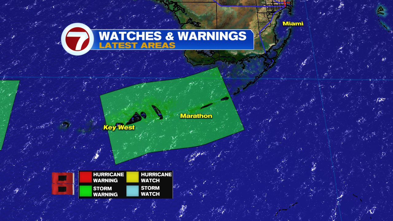
The National Hurricane Center (NHC), has issued a Tropical Storm Warning for portions of the Florida Keys. Tropical Storm Laura will pass to the south of the island chain but some of its effect can be felt across the area.

Satellite

Laura has been moving mostly over the southern waters of Cuba with most of the heavy rain over Jamaica and Grand Cayman.


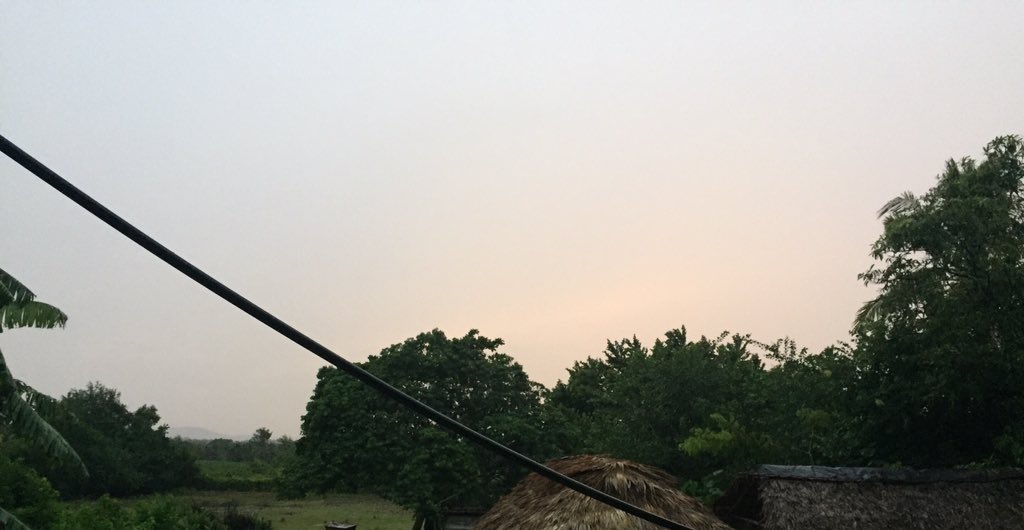
A report from Eastern Cuba said most of the gusty winds happened around 1 am for a while,  but very little rainfall.  

The picture shows the sunrise around 7 am Monday morning with mostly dry conditions. Eastern Cuba was spared the wrath of Laura that descended upon Haiti and Dominican Republic over the weekend where rain led to flooding and casualties. 
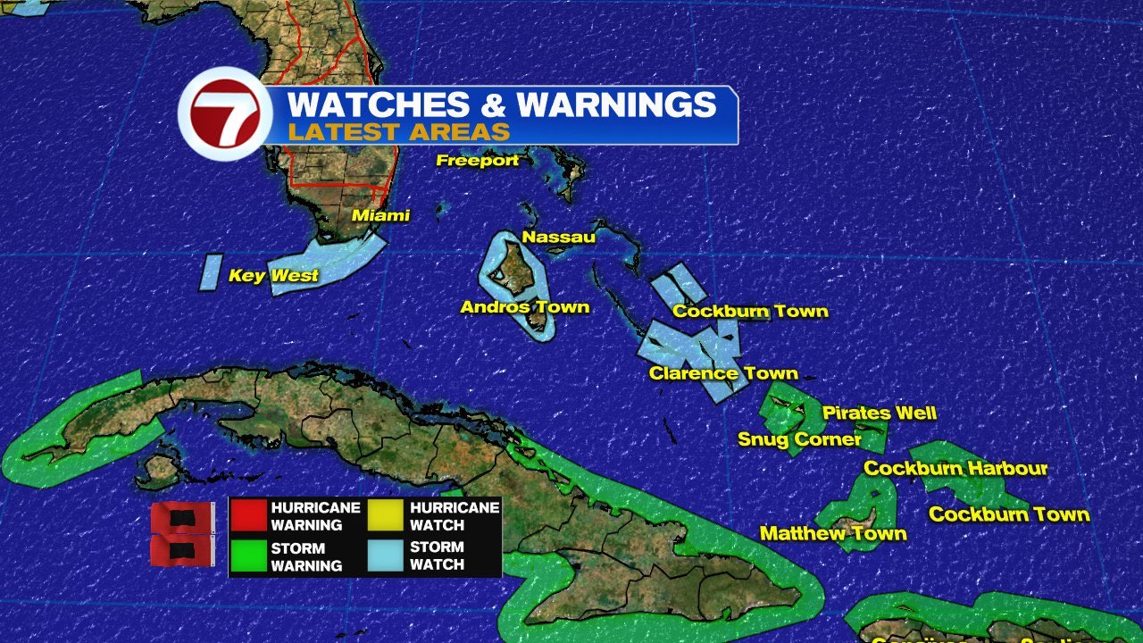
Key's Advisories

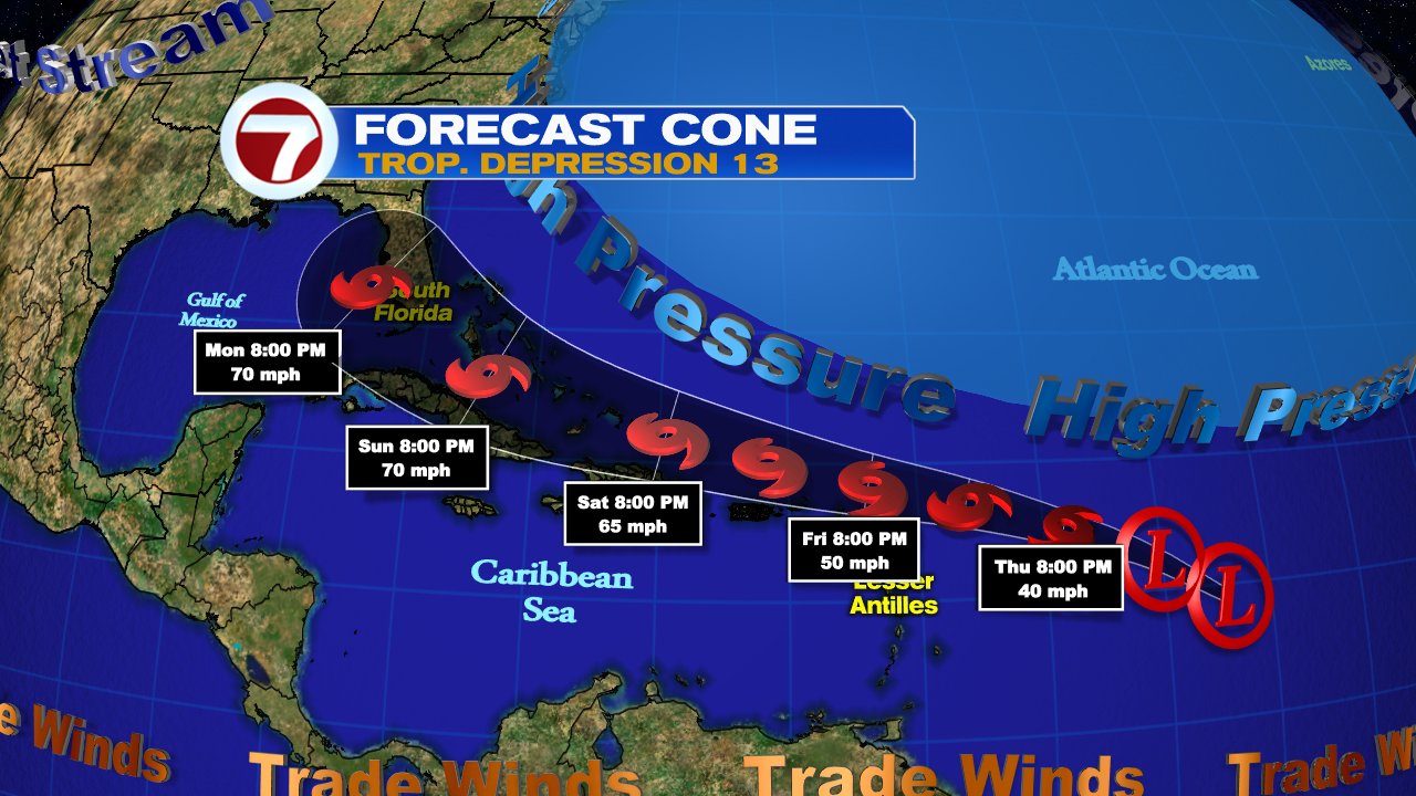
Laura will move west with its tropical force winds of up to 65 mph fanning out from the center up to 175 miles. 

  • A tropical Storm Warning is in place form Craig Key to Key West. This means that sustained winds over 39 mph are EXPECTED in less than 36 hours.  
  • A coastal flood watch is also in effect. Tides are running about half a foot above normal levels. High tides may cause flooding of roadways.

Impact info from NWS Key West Office


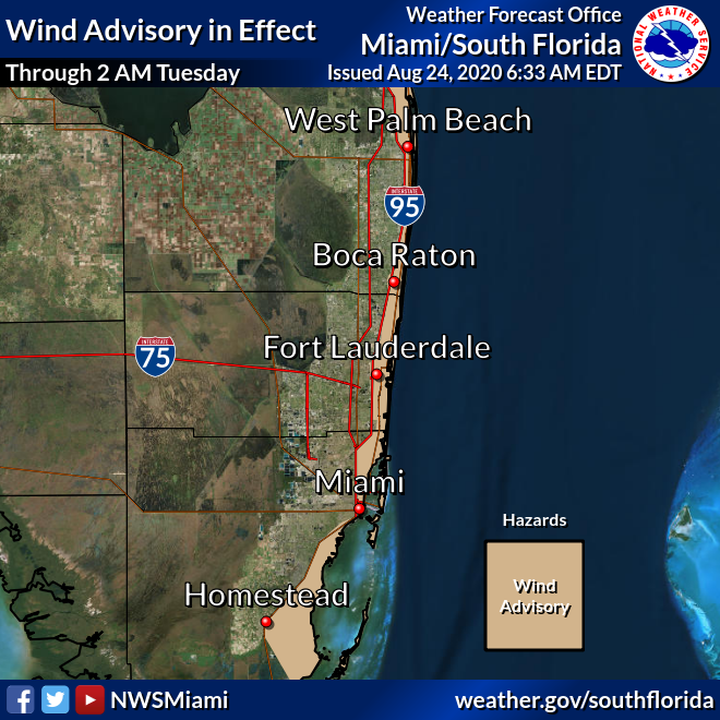
Impacts for Miami-Dade, Broward Counties

This area is being squeezed between high pressure and Laura. This combo will keep the region windy to gusty at times with some fast moving downpours through Tuesday morning. Thats when Laura is expected to make its approach into the Gulf.

  • A Gale Warning has been issued for the Coastal Waters where winds can reach 30 mph as well as a Wind advisory for all of the areas East of I-95 in Palm Beach & Broward counties, and East of I-95 and US1 in Miami Dade. 

Stay up to date on where the strongest rains are located with the NWS radar loop.

What is Next?

Laura will hug the South Cuban Coast for much of the day and finally moving into the Gulf of Mexico early Tuesday morning. There it has a chance to strengthen into a hurricane.  

  • The remaining impacts will be for Jamaica and Cuba with rain totals near 4 to 8 inches with a few spots receiving as much as 12. Flooding will be a major threat.
  • Cayman Islands are forecast to see totals of 2" - 4" with the Turks & Caicos and NW Bahamas between 1" - 2".

Its next stop should be Coastal Texas/Louisiana on Wednesday.

Marco

Fortunately Marco is losing its punch and not forecast to make landfall as a hurricane but still capable of gusty winds and heavy rain. It will slide across Louisiana and Texas, Monday & Tuesday.

Final Note

Today is the 28th Anniversary of infamous Hurricane Andrew which slammed the Homestead area with category 5 winds. Those who lived through it will never forget. 


We'll be watching


Sunday, August 23, 2020

Laura Looking Better

Over the last few days we were mentioning how disheveled Laura appeared,  as of Sunday morning,  that has changed. Laura is looking very healthy.

That has been unfortunate, because it has tracked over Puerto Rico, Dominican Republic, and Haiti with torrential rain and howling strong gusty winds. The center moved over Santo Domingo around midnight and has hugged the Southern Coast of Haiti through much of the night.

Satellite


Sunday morning the system is more symmetrical.  Notice the circulation with winds rushing in at the surface towards the center in a counterclockwise fashion. They are feeding the center with the moisture it needs. 

Now look at the upper portion of the satellite loop and you will see clouds streaming in the opposite direction... those are the same winds rushing out but in the upper levels of the atmosphere. It's known as outflow. When you have that, the engine is firing on all cylinders.

Track

Models all keep the center of the storm mostly over Cuba. Tropical storm force winds of over 39 mph, fan out from the center 140 miles. Depending on the position of the center as it passes south of Florida, some of those strong gusty winds and rain could impact the Keys.

Next 24-48 hrs for South Florida

The Keys: Tropical Storm Watch in effect from Ocean Reef to Key West. This means winds greater than 39 mph, heavy rain, and rough marine conditions are POSSIBLE.  This would be the time to finish any preparations you may need.

  • Tropical storm force winds are possible for much of Monday until the system moves into the Gulf of Mexico.  
  • Some strong rain bands with winds up to 50-55 mph are possible Monday afternoon. 
  • 1" - 3" inches of rain are forecast
  • Marine conditions will be rough. Large waves can be expected in the south facing shores. 
  • Tides are running over half a foot above normal. The storm could cause an additional 1 - 2 feet of saltwater flooding at the next high tide. The high tides on Monday will be at 2:13 am and 3:16 pm.

Miami Dade and Broward: The impacts should be minimal. As of this update NWS does not expect Marco in the Gulf to have any impact on Laura's Direction.

  • As Laura moves closer to the region, winds are forecast to pick up. 
  • Some pockets of heavy rain could move through the area 
  • Winds 25 - 35 mph with possible higher gusts during a rain band 
  • Even as Laura moves into the Gulf, squally weather may be present through Tuesday.

The Islands

Laura's center has been hugging the Southern Coast of Dominican Republic and Haiti with strong winds and torrential rains. This will cause dangerous flooding conditions on Sunday.

The system has also shifted further west. The center should stay mostly over Caribbean waters rather than crossing into the Atlantic and emerging over the North Coast of Haiti. This should keep the center fed with warm ocean moisture and not have a direct impact with any of Haiti's high terrain. Laura should then track over Haiti, then directly over Cuba for much of Sunday and Monday. The entire island will be impacted. 

Impacts:

Heavy rainfall can be expected as the storm moves west. Flooding, land, and mudslides are possible for much of Sunday.  

  • Dominican Republic & Haiti: Up to 12 inches of rain are forecast 
  • Turks and Caicos, SE Bahamas, & Jamaica: 1 - 3 inches of rain possible :  
  • Central Bahamas & Andros Island: Tropical Storm force winds and some heavy rain is possible late Sunday and into Monday. 
  • Cuba: Conditions to worsen late Sunday. Heavy rain and very strong gusty winds will travel the entire length on the island through Monday/Tuesday.
  • Jamaica: May also get squally weather as the system moves north of you.

What Next?

Once in the Gulf Laura could intensify into a category two before making landfall across Louisiana sometime Wednesday. Normally that would be terrible, but a mere 48 hours earlier they would have been struck by Marco an expected hurricane by then.

Here's is some interesting data regarding Gulf Systems

Rare Pair - Two in the Gulf

  • Laura and Marco would be the third time in history that two named systems were in the Gulf of Mexico at the same. The others were, Treasure Coast Tropical Storm and Cuba Brownsvile Hurricane 9/5/1933 and Tropical Storm Beulah and unnamed Tropical Storm in 6/18/1959


Not the first time Louisiana has had more than 1 hurricane hit in a season

  • 3 times in 1860 ( Hurricanes 1,4,6)
  • 2 in 1893 ( Hurricane #8, Chenier, Caminanda)
  • 2 in 1985 ( Danny & Juan)
  • 3 in 2005 ( Cindy, Katrina & Rita)


Shortest time between two HURRICANE strikes

  • If Marco and Laura hit as hurricanes, the previous time gap between hurricanes in Louisiana was 17 days.
  • Hurricane #4 and the Hurricane #6 in 1860. * prior to 1950 hurricanes were not names, unless they were truly devastating such as Chenier and Caminanda. 
  • In general-- The shortest time between two hurricane hitting anywhere in the U.S. was 23 hours in 1933. They were the Treasure Coast hurricane on 9/4/1933 and then the Cuba-Brownsville Hurricane on 9/5/1933. 

Last Louisiana Hurricane Impact in August

  • Cat 1 Isaac in 2012. 
We'll be watching.

Saturday, August 22, 2020

Keys Under a Tropical Storm Watch

 The Keys are under a Tropical Storm Watch as of Saturday afternoon. This is due to Tropical Storm Laura forecast to be near the area on Monday.

A watch means that tropical storm force winds are possible, along with heavy rain, and storm surge within 48 hours. It doesn't mean it will happen, but it is possible given the proximity of the storm. Now is a good time to prepare for any possible impacts.

The watch is for all of the Florida Keys from Ocean Reef to Key West and the Dry Tortugas. Northern Cuba is now also under a Tropical Storm Watch. (Not shown in graphic) 

Cone of Concern

Laura is expected to remain as a storm as it moves over the islands. By Monday, the center should be somewhere in the shaded area. It nom longer includes the Lower Keys.

The rain bands reach far away from the center and Tropical Storm force winds fan out up to 205 miles. This is why the Watch was issued. 

What is possible


The National Weather Service says there is a small potential for on and off gusty winds, heavy rain, and an even an isolated tornado.

NOTE- NWS says if TS Marco gets any stronger in the Gulf of Mexico, it may slow down the high in the Atlantic that is supposed to steer Laura into the Gulf. This may alter its path and the impacts across South Florida.

Keep an eye on Laura until its in the Gulf of Mexico. 

Island Impacts

Puerto Rico & the Virgin Islands have seen plenty of heavy rain and gusty winds from Laura. Many areas have received between 3 - 6 inches with 8" in spots.


The center of Laura is over  Dominican Republic and Haiti . It will deliver heavy rain and gusty winds overnight. Haiti will see the impacts moving in early Sunday morning. Forecasts are calling for 4 to 8 inches with some areas up to 12 inches.  This could lead to dangerous flooding, land and mudslides.

Turks and Caicos, Southeast Bahamas, and Jamaica are looking at the potential for 1 to 5 inches.

Laura is also producing rough seas with large swells expected across the coasts of the Leeward Islands, Puerto Rico, Dominican Republic and Haiti. The swells will push across Cuba, Bahamas, and the Keys over the next 48 hours. 

Haiti

The center is roughly 600 km East from Ouanaminthe. The center will be near the Haiti/Domincan border by 2 am. The nation is under an orange alert. Please pay attention to local authorities.

Dominican Republic

All the red areas are under red alert. Expect heavy rain and gusty winds overnight . 

Cuba

For the moment the entire island is under a Tropical Storm Warning. Things will begin to deteriorate from the East Coast westward by Sunday afternoon/early evening.

Bahamas


There are watches and warnings for many of the islands including the Turks and Caicos. Please prepare accordingly as you could be impacted with winds over 39 mph and heavy rain as early as Sunday afternoon.

I'll keep you up to date, on-air and on-line.


Laura & Marco

 Tracking Two

Laura remains disheveled in the Eastern Caribbean Sea while Marco is in the northwestern Caribbean getting stronger as of Saturday morning.

Laura

Laura shows signs every once in a while of getting its house in oder with better defined surface circulation and more pockets of heavy rain. However, it quickly goes back to being just a big mass of clouds and rain. 

Its organization or lack thereof, will be something to watch the next 48 hours. There is very little shear, or strong upper winds that could keep it in check, this may give it an opportunity to grow. But, it still has plenty of interaction with land areas ahead that should limit that possibility.

Laura's Track

The feature guiding Laura's movement has not changed, and that is a huge dome of high pressure in the Atlantic Ocean.  It will move west dragging Laura along for the next 3 days until it moves in the Gulf of Mexico. 

Something to keep in mind, a tropical system does not travel in a straight line, they spin as they move forward. This spin will make Laura wobble north and south over the next few days. Once in the Gulf it could briefly reach hurricane status as it moves towards Louisiana. This will only come to pass it Laura can remain a tropical system. It will move over plenty of mountainous terrain from Dominican Republic, to Haiti, and much of Cuba. If any of it is left after that, it may have a chance at reaching hurricane strength.

If it reaches the Gulf, it could catch up to Marco. Most forecasts suggests they will remain far apart from each other. If they do interact, then maybe the Fujiwara effect may come into play. See my previous post on this.  

Impacts

  • Leeward Islands, Virgin Islands, & Puerto Rico: Winds over 39 mph with higher gusts at times with the potential for heavy rain for the rest of Saturday. One to three inches with isolated pockets of five inches are possible.
  • Later Saturday into Sunday, the wind and rain picks up over Dominican Republic, Haiti, Turks and Caicos, as well as the SE Bahamas. Three to six with up to eight inches of rain are possible.
  • Central Bahamas & Eastern Cuba could see those tropical storm force winds and the rain on Sunday.
Flooding, land and mudslides are a concern for all in Laura's path.

While only the Lower Keys remain in the cone, squally weather may be possible over South Florida on Monday.  The overall health of Laura as it nears South Florida, will determine the impacts.

Marco

The tropical storm is forecast to strengthen as it makes its way into the Gulf of Mexico on Sunday. Once there, it could try to reach hurricane status, but as of this moment, NHC suggests it may struggle to do that. 

They kept it as a tropical storm in the forecast as of Saturday morning. The northeastern edge of the Yucatan Peninsula may feel some of Marco on Saturday, eventually it will get steered towards the Louisiana/Texas Coastline by the early part of next week.


Friday, August 21, 2020

TS Laura & the Fujiwara Effect?

Hurricane Hunters Find TD13 has strengthened into Tropical Storm Laura


Overview:

The image shows a comma shaped cloud pattern just east of the Leeward Islands. The system is exposed to dry air to the south with rain only on the northern side. The structure is also elongated with the center at the surface being hundreds of miles away from the center in the midlevels of the atmosphere. 

Having said that, NOAA recon found TD13 strong enough to be upgraded to tropical storm Laura. This sets a record for the earliest "L" storm. The previous title holder was Luis from August 29, 1995.

Impacts:

  • The Leeward Islands, Dominican Republic, Haiti, Turks & Caicos, & SE Bahamas, the forecast calls for 1" to 3" with some areas as much as 5" 
  • For theVirgin Islands & Puerto Rico, totals range between 3" - 6". This may lead to flash flooding.

Where is it going?


There is not one perfect model. If there were we would only need one. Each is tasked with a different parameter to forecast. This is what you see in the cone of concern from NHC which is a combination of all the runs.

For the next 3 - 4 days, the forecast track remains almost unchanged, with the Atlantic High Pressure system pushing Laura northwest. By the time it nears South Florida, the high retreats and allows the system to turn more to the north. Laura could be in the Gulf of Mexico by then.

The GFS & UKMET models have the system practically moving over the Caribbean and South of Cuba. This would keep it weak as it would interact with land. It would however cause heavy rain and gusty winds. Flooding would be an issue for our neighbors to the south.

How strong will it be?

This graph, courtesy cyclone cane.com, shows how strong the system could actually get.  The bottom shows hours in time. The forecasts are all over the place with just as many keeping it as a depression as there are intensifying it to a hurricane. A handful push it to major hurricane in 5 days with winds over 111 mph.

We should keep a close eye on Laura. There could still be many fluctuations in strength and direction. 

Now comes the interesting part: The Fujiwara Effect

Once Laura is in the Gulf of Mexico, it may come very close to TD14. This may alter their trajectories turning both of them more towards the north-northwest. 

What happens if they meet?

If they get close enough where their outer rain bands can touch, the larger system absorbs the smaller one. This is known as the Fujiwara Effect. 


The last time this happened was in 2017 in the Pacific Ocean where the larger system, Hurricane Hilary on the right, absorbed the smaller Tropical Storm Irwin on the left. They do not become one huge mega hurricane.  For this effect to happen, it would need plenty of open water. IF both TD13 & 14, reach the same region it would be too close to land. It could however, dump plenty of rain across the Gulf States.


Thursday, August 20, 2020

TD 13 Intensity Woes

The National Hurricane Center is keeping a close eye on TD 13. It's proving a bit difficult to forecast how strong it will be down the road.


TD13 is forecast to turn into Tropical Storm Laura late Thursday, but after that, its strength remains uncertain. Some models dissolve it into a wave while others intensify it greatly.

What we know:

  • Tropical storm force winds and heavy rain are possible across the Northern Leeward Islands by Friday evening. 
  • Puerto Rico and the Virgin Islands could see conditions deteriorate Friday night into Saturday morning. Watches and Warnings may be issued for you later today.
  • If TD 13 does not get any stronger than a tropical storm, it is still capable of heavy and gusty winds across Dom. Republic, Haiti, Turks & Caicos, Bahamas, Cuba & South Florida over the weekend.

Model Woes

The atmosphere surrounding TD 13 appears favorable for further strengthening with light to moderate shear (strong upper level winds that could keep it in check). It's also traveling over warm waters.

Some models like the HWRF (Hurricane Weather Research & Forecasting) and HMON  (Hurricanes in a Multi-scale Ocean Non-hydrostatic) show TD13 reaching major hurricane status in 5 days.


The UKMET (United Kingdom Meteorological Agency Model) and the Global Environmental Multi Scale aka Canadian model, keep it as a storm

The GFS (Global Forecasting System) is insisting on a stronger solution with the system near South Florida by Monday. 


The ECMWF (European Centre for Medium Range Weather Forecasts) weakens the system to just a tropical wave. This downward trend could be because of dry air getting in its path from some Saharan Dust. It also suggests high pressure to be fairly strong and possibly push the system south of South Florida and into the Gulf. We are hoping this scenario pans out.


Bottom Line: The islands needs to monitor closely. Pay attention to your local authorities. South Florida needs to stay alert. The possibility is high that we may see a tropical system over us late in the weekend or Monday. Unsure how strong it may be.


South Florida in the Cone

 The National Hurricane Center (NHC) began issuing advisories on Tropical Depression 13, Wednesday night.

It organized from Invest98L, a low pressure system spinning in the middle of the Atlantic Ocean. NHC says it is already developing feeder bands as it moves west northwest.  

The system should become Tropical Storm Laura on Thursday evening. This would set a record for the earliest "L" storm. The current record holder is Luis from August 29th, 1995.

Where is it headed?

High Pressure will push it quickly to the west and track near the Leeward Islands by the end of the week.  Heavy rain is expected there. It should then move close to Puerto Rico, Dominican Republic, Haiti and the  Bahamas by the weekend.

Wind shear will be mostly absent as it travels over very warm waters. This could allow it to grow in strength.  Intensity forecasting is very difficult so we need to monitor this closely. 

Things to watch:

  • If TD 13 takes a more southward track, directly over the Greater Antilles, it could stay as a weaker system. Unfortunately this could mean a greater impact for Puerto Rico and Hispaniola in the form of heavy rain that could lead to flooding. 
  • If the system tracks just north of Hispaniola, it has a chance to grow in strength. Maybe reaching hurricane status.
  • Even if this system does not get any stronger, it could drop heavy rain over Hispaniola, Cuba, the Bahamas and South Florida over the weekend thru early next week.
Please prepare accordingly. Head the advice of local governments. For South Florida, advisories may be issued by the first half of the weekend.


Wednesday, August 19, 2020

Tropical Trio

Things are really heating up in the Tropics with three areas being watched by the National Hurricane Center (NHC).


Satellite imagery shows three cloud swirls from the West Coast of Africa to the Caribbean Sea, these are the features NHC is monitoring.

Invest97L

This tropical wave is moving west between 15 and 20 mph with plenty of thunderstorm activity as shown in this infrared imagery. Where you see the darker colors is where most of the heavy rain can be found. 

Chances for development remain high Wednesday morning, at 80% A recon mission is set for Thursday if need be.

Where is it going?


Models suggest, once Invest97L nears Central America it will start turning Northwest towards the Yucatan Peninsula/Gulf of Mexico. There is the best chance for organization. South Florida will watch where it finally ends up. We may get some rain from it. The timing is still not certain. Could be late in the weekend to early next week. We'll keep monitoring.

Invest98L

Satellite loop shows a broad spin in the Atlantic roughly midway between the Lesser Antilles and Cape Verde. If you could split the system in two, the western sector is where you find most of the rain while the eastern side remains dry at the moment. A NOAA high altitude mission is also on standby for Thursday.

The chances for development remain unchanged since Tuesday night at 90%. If it organizes it will do so in area shaded red.

Where is it going?

This is the feature that has many of us concerned and rightly so. If these models pan out we could be dealing with a tropical system by the middle of next week.  

Here are the facts:

  • Nothing has organized yet, so these models are just giving an educated guess. 
  • Models are split, with some developing a strong system and others keeping it very weak. 
  • Once it develops, better projections will be issued along with a cone of concern. 
  • The cone will give us the best idea of where it may end up.
  • Plenty of time to watch in South Florida

While the worry meter is not low on Invest98L, by no means is it high. This is a great reminder that we are in the most active part of hurricane season with its peak next month. This is the time to calmly check what you need in case Mother Nature sends this storm our way, This goes for everyone from the Leeward Islands, Virgin Islands, Puerto Rico, Dominican Republic, Haiti, Cuba, and the Bahamas.

And then there were three

This is a tropical wave that is still over the West Coast of Africa. It is a very healthy wave with plenty of thunderstorm activity. It should move offshore late Wednesday.

NHC is giving this feature a 20% chance for organization once it reaches the yellow shaded area. No models are available for this wave yet. It's not even an Invest. All we can do is monitor it.

We'll be watching


Tuesday, August 18, 2020

Two on the Verge

 The National Hurricane Center (NHC) is watching two systems on the verge of development on Wednesday.

The first is a Tropical wave roughly 1000 miles away from South Florida, and the other is an area of low pressure about 2300 miles away from our area.

Tropical Wave in Caribbean

NHC has its chances for development at 80% over 5 days in the area highlighted. A recon plane is on stand-by for Thursday if needed.

Where is it going?


If it were to develop, the models show a westerly track through Friday and then a turn to the north by Saturday. As it nears the Gulf of Mexico, some rain may get spun out and sent to South Florida.

Area in the Atlantic

This area of low pressure Invest98L, has many worried about its future track. For the moment NHC says it may organize in the area shaded red. If it reaches tropical storm status, it will be named Laura. 

Where is it going?

Keep in mind nothing has developed yet. Because of that, models are guesstimating at this point. As of Tuesday night, they were thinking the system could go close to the Leeward Islands by Friday/Saturday. After that, everyone should monitor carefully.

This is a great reminder we are quickly reaching the peak of hurricane season and we should all be prepared in case Mother Nature sends us something. It's a great opportunity to review your plans and supplies.

We'll be watching