Tuesday, September 5, 2017

"Irma" Category 5

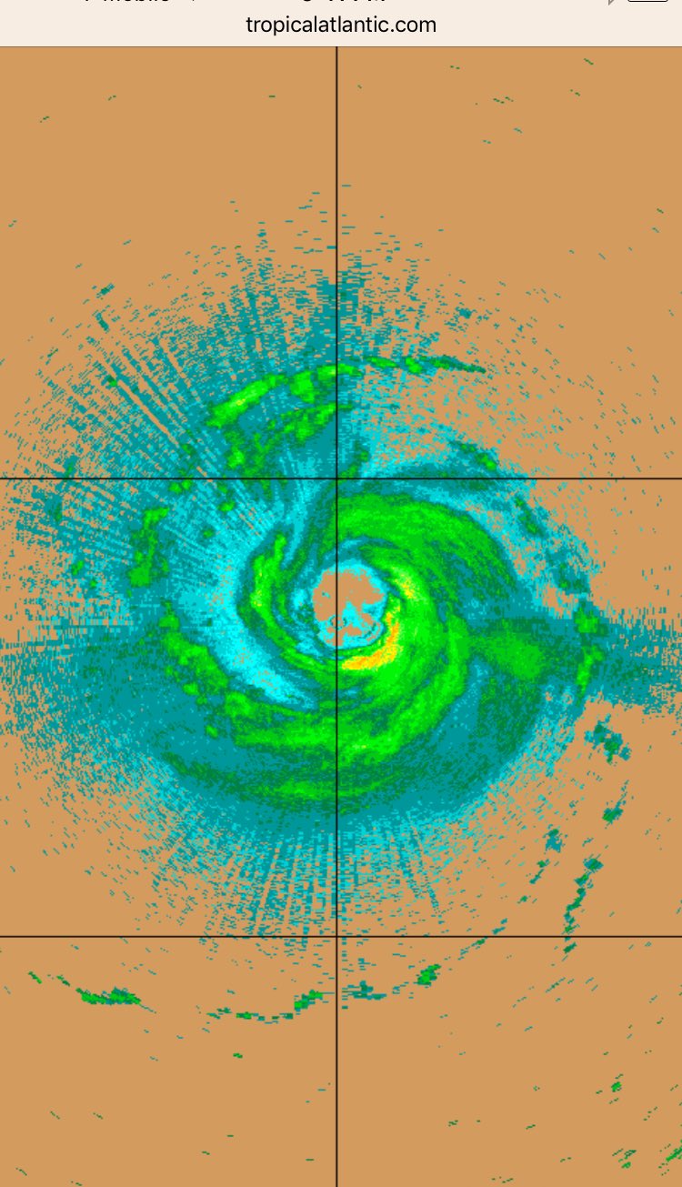
Early Tuesday morning hurricane hunters found "Irma" to be stronger with winds of 175 mph.


Headlines
  • NHC says there's an increasing chance that South Florida may see some impacts from "Irma"
  • Please prepare now as if we will get a direct hit. We will have a couple of good weather days that will give you the opportunity to prepare your property and get the supplies you need.
  •  A catastrophic event is in store for the Northern Leeward Islands with 175 mph winds, heavy rain, flooding, and a surge of 6 - 9 feet.
  •  Puerto Rico could see winds just as strong with heavy rain starting by Wednesday. You are under a hurricane warning.
  •  Hispaniola has a hurricane watch in effect. Turks and Caicos, the Bahamas and Cuba will also see some impacts form Irma by the end of the week.


Where is it headed?

All the models place it near the Straits Friday-Saturday, stopping and aiming north across the entire state. The possible "Saving Front" may not arrive in time to deflect the system over the Western Atlantic. Instead, it appears "Irma" will move over us.


Worry Meter

Northern Leeward Islands: EXTREME- You will be impacted by a cat 5 as early as Wednesday morning.

Puerto Rico, Hispaniola, Cuba & Bahamas: ELEVATED. Possible cat 5 winds with heavy rain ahead. Finish your preparations now.

South Florida: VERY HIGH: Now is the time to review your hurricane plans, and get the supplies you need. If nothing changes with this forecast, we could be dealing with a powerful Cat 4 by the weekend.
Please take this seriously, it may be very close to us by Friday.


.


sdfsf

Monday, September 4, 2017

South Florida in the Cone of Concern

Irma still a powerful hurricane that may impact South Florida  by the weekend.


Headlines

  • South Florida is now under the cone of concern of concern. This is the time for you to prepare, check your hurricane plan, and supplies. Do it before watches and warnings are issued. Here's a good link you can use for a list of supplies and steps you can take to get ready.


  • Hurricane force winds will start impacting the Leeward Islands late Tuesday. You should complete your preps and be ready to meet the storm head on.
  • Irma will then make its way towards the Virgin Islands, possibly Hispaniola, Cuba and the Bahamas on Wednesday and Thursday. You should be preparing now.


Forecast Cone

Everyone inside the cone should be getting ready for a brush with "Irma". Please prepare now for what could be a strong hurricane for South Florida by the weekend.


The Worry Meter
Leeward Islands EXTREME: You can expect tropical storm force winds moving in by Tuesday
Puerto Rico, Hispaniola, Cuba, Turks and Caicos, Bahamas: ELEVATED. Get ready now, you may be dealing with a storm by midweek.
South Florida: Moderate to High: get ready now as a system may be here by the weekend.

I'll keep you posted


Concern grows for Florida

As of 11 am Monday morning these are the Watches & Warnings in place:
A Hurricane Warning is in effect for...
* Antigua, Barbuda, Anguilla, Montserrat, St. Kitts, Nevis
* Saba, St. Eustatius, and Sint Maarten
* Saint Martin and Saint Barthelemy

A Hurricane Watch is in effect for...
* Guadeloupe
* British Virgin Islands
* U.S. Virgin Islands
* Puerto Rico, Vieques, and Culebra

A Tropical Storm Watch is in effect for...
* Dominica

Headlines

  • "Irma" will move in on the Leeward Islands Tuesday as a major hurricane, strong deadly winds, downpours, and deadly coastal surge. COMPLETE your preps now.
  • The Virgin Islands, and Puerto Rico will be next feeling the storm on Wednesday. Advisories in place there as well.
  • Watches may be issued for Hispaniola as well as the Turks and Caicos, Bahamas, and Cuba at anytime over the next 24 hours.
  • FLORIDA: NHC now says our chances for "Irma" impacts are growing as we move into the end of the week or weekend. I like to err on the side of caution. Review your plans and supplies now. Do not wait until advisories are issued. I am hoping this will all be an exercise in preparedness. Hoping for the best.
  • NOAA planes will fly today over the continental U.S. to get a better idea of a possible "Saving Front" that may arrive and hopefully protect us from "Irma". This new info will be released by 8 pm tonight.


Health
I wish I had better news, but it is looking better and better on satellite imagery. The eye is much larger with multiple eyewalls.


Nothing is in its way to weaken it or deflect it over 5 days.


Worry Meter:
Leeward Islands: EXTREME- You are in the path of a major hurricane. COMPLETE preps now.

Puerto Rico, Dominican Republic, Haiti, Cuba, the Bahamas: Elevated- You are in the cone of concern and are likely to be impacted over the next 3 days. Make sure you have the supplies you need.

Florida: Medium- If nothing changes, watches and warnings may be issued for us over the next 24 - 48 hours. I would make sure I have what I need as far as supplies, medicine, pet food etc.
Here's our web site for helpful tips on preparing:     http://wsvn.com/news/surviving-a-storm/

I'll keep you updated

Sunday, September 3, 2017

Worries rise with Irma

The eye of "Irma" may come too close for comfort in the Caribbean.

We start this first week of September, with all eyes fixed on powerful and compact Hurricane "Irma".


Headlines
  • Hurricane watches remain in effect for Antigua, Barbuda,Anguilla, Montserrat, St. Kitts, Nevis, Saba, St. Eustatius, St Maarten, St. Martin, and St. Barthelemy.
  • If nothing changes with the track, "Irma" should approach the Leeward Islands on Tuesday night/Wednesday morning
  • It is forecast to stay as a major hurricane throughout the week.
  • It may get even stronger over the next 2 days.
  • NHC says, "Irma" may directly affect the Virgin Islands, Puerto Rico, Dominican Republic, the Turks & Caicos, and the Bahamas. For you in these areas, please monitor your local authorities for updated weather warnings. 
  • Watches & warnings may be issued for the Virgin Islands and Puerto Rico at any time through Monday.
  • NHC says its still too early to tell if "Irma" may impact Florida or the rest of the U.S. Coastline.
  • I will err on the side of caution and urge you in Florida to review your hurricane plans and supplies. Its always best to be ready before advisories are issued for South Florida.

Health
"Irma" remains a compact but intense system. 

Even though the eye was not visible at times on satellite, an afternoon recon mission found it well formed with a healthy eyewall. This is the ring of destruction where the strongest winds and heaviest of the rainfall resides.

This is the radar image directly from the recon flight.

Hurricane force winds reach out from the center up to 35 miles while tropical storm force winds extend outward 140 miles.

There is really nothing significant ahead of it over the next 5 days to weaken it or deflect it.

It should remain on a mostly West/Southwest course throughout the next 48 hours then start a turn for the northwest after that.

Where is it headed?
The experts at the National Hurricane Center rely on models to give them an idea of where "Irma" may end up. The atmosphere is ever changing and so are the models. They vary from run to tun and can have huge forecast errors 5 - 7 days out. Sometimes as much as 240 miles in both directions. So focusing on a line is not the best course of action. These are used as a gauge and not a preset track.

These are the spaghetti models which show where the center, or eye, may be in the days ahead. Notice how tight they are by the Leeward Islands, this is a clear consensus of where "Irma" will be. They fan out however as they near the Bahamas, Florida, and the East Coast, with each line having a huge forecast error by day 5.


These are individual runs. The European says High Pressure will not budge, shown in the red shaded area, and puts a green blob (Irma) over South Florida by the 10th of September.


The GFS puts an extremely strong hurricane over the Bahamas and near South Florida also on the 10th.


NHC takes these and other models into account and issues their cone of concern.  Everyone in the areas highlighted should be getting ready for the possible arrival of "Irma".  Review your plans and supplies and for you in the islands you should complete your preps as soon as possible.


To give you a better idea of potential impacts, NHC has come up with a graphic that shows more or less the time when you may get Tropical Storm force winds, greater than 39 mph.


The Worry Meter:
Leeward Islands: HIGH. Complete your preparations. Hurricane watches are in place. Follow the advice of local authorities. Gusty winds may approach as early as Tuesday night.

Virgin Islands, Puerto Rico, Dominican Republic, Haiti, Turks & Caicos Bahamas: ELEVATED. Review what you need and be ready for advisories to be issued soon. Keep a very close eye on the storm.

Florida & U.S. Coast: Moderate. Even though NHC says its too early to tell where it may end up, I would be checking my supplies and hurricane plan just in case. At worst we may be dealing with a hurricane in South Florida by the weekend, at best - this could just be a big scare.

I'll keep you posted.


Irma's Health Check

"Irma" Remains a strong hurricane in the Atlantic


Headlines
  • Expected to remain a major system as it nears the Leeward Islands. Watches & Warnings may be issued later today.
  • The Virgin Islands & Puerto Rico may also be impacted later in the week. Watches and warnings may be issued there sometime Monday.
  • Dominican Republic, Haiti, Turks & Caicos & the Bahamas should monitor the path carefully. If nothing changes with the trajectory of the cone, you too may see advisories issued.
  • Florida and the rest of U.S. East Coast, NHC says its too early to determine where "Irma" may finally end up.


Where is it going?

Short term: Most models agree the eye may pass very close to the Leeward Islands by the middle of the week.  Cannot rule out a direct impact.

Long term: By the end of the week it may be anywhere in shaded area which includes, Puerto Rico, Dominican Republic, parts of Haiti, Turks & Caicos and even the Central Bahamas.


Latest Models

Keep in mind the atmosphere is fluid and ever changing. Forecasts are not set in stone and that is why they are updated every few hours.  Also, the farther out in time you go, the greater the forecast error. By day 5, each one of these little lines has an error of over 240 miles in either direction. These models go out 7 days so the spread is even larger. That is the problem with focusing too much on long range outlooks.


Worry Meter
Leeward Islands: HIGH. I would try and complete all your preparations.  Watches may be issued for you at any time. Do it now and be ready just in case.

Virgin Islands & Puerto Rico: Elevated. Review what you need and be ready for advisories to be issued for you early this week. Keep a close eye on the storm.

Dominican Republic, Haiti, Turks & Caicos & the Central Bahamas:  Medium.  Even though this system is far away, and many things can happen, it is forecast to be a strong hurricane by the time it nears the area. Review your hurricane plans and be ready when and if local authorities implement watches and warnings.

Florida & U.S. East Coast: Low. NHC and the models say its too early to tell where "Irma" may end up. I always err on the side of caution and urge you to review your plans & supplies now. At worst we may have a strong hurricane in our hands by next weekend, at best- this may just be an exercise in preparation and readiness.

I'll keep you posted


Saturday, September 2, 2017

Latest Assessment on "Irma"

Hurricane "Irma" remains a strong storm in the Eastern Atlantic over 1000 miles east of the Leeward Islands.

Hurricane Headlines

  • The Leeward Islands should watch it closely.  Models suggest "Irma" may grow in size during the next 3 days, this may determine when advisories will be issued for you. It could also arrive as a major system,  111 mph winds - Cat 3 or above.
  • Recon flights begin on Sunday with NOAA planes, followed by Air Force's Hurricane Hunters on Monday.
  • It is way too early to say whether "Irma" will have any impact on Bahamas, FL, or any other part of the U.S.


"Irma's" Health

The system has changed very little over the last 24 hours and remains an intense but compact hurricane. The strongest winds extend out from the center 25 miles, while tropical storm force reach out to 70 miles.

Its eye is visible .

While "Irma" may be a small system (size-wise), it promises to grow larger over the next 3 days. This will determine when watches and warnings are issued for the Leeward & Virgin Islands.

Even though "Irma" is being impacted by some dry air, it really hasn't taken a huge toll on it.

In the next few days, it should reach warmer waters and additional moisture which could aid in intensification.

At the same time, it will run into some strong upper level winds which may help to weaken it. In this case, the models keep it more or less near Cat 3 strength.

Unfortunately, there is also the possibility "Irma" could get stronger sooner before reaching the shear.


Where is it going?

The official cone from NHC shows the system near the Lesser Antilles, Puerto Rico, & even Eastern Dominican Republic by Thursday. It can be anywhere in the shaded area. After that, models are shifting back and forth and real determination of its final destination is still highly questionable.


High pressure to the North (Bermuda High) will continue to push "Irma"west-southwest. By the end of next week, it will be close to the Western Edge of the Bermuda high. The question will be what "Irma" does next. Depending on how soon it can make the turn north, it may come dangerously close to the Leeward Islands.

They should be ready for dangerous winds, heavy rainfall that could lead to flooding, land and mudslides, and storm surge.


The Worry Meter

For the Leeward Islands & Puerto Rico: Elevated. I would be making sure I had the supplies I need along with food and water. This is a powerful system that promises to be near you in the days ahead.

The Bahamas, Dominican Republic, Florida & beyond: Low.
There are too many variables. Review your storm plans and make sure you have what you need. Hopefully this will just be an exercise in preparedness.