Saturday, October 28, 2017

New Tropical Storm Philippe to move over us tonight

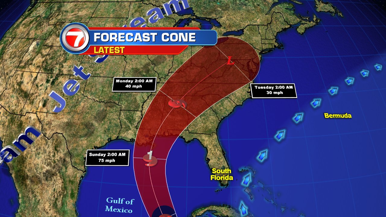
The area south of Cuba we've been watching has become Tropical Storm Philippe

As of the 5 pm advisory NHC has upgraded tropical depression 18 into a tropical storm. This is quite an interesting system. From time to time it has a typical symmetrical look to it and at others it appears to be lacking some organization.  The satellite imagery suggests plenty of cloud cover and rain across portions of Cuba and the NW Bahamas.

South Florida has seen its fair share of downpours and should still see more through the night.


A new spin has developed within the system that should be absorbed by the main center later tonight.

Models now show the center moving over Florida Bay and into Extreme Southern Miami Dade County later this evening.

Impacts:
The center should make landfall over the Upper Keys / Deep Southern Miami Dade county tonight.
  • Because of the structure of this system, the strongest winds will remain offshore, but cannot rule out a tropical storm force wind gust.
  • The main impact for South Florida will be the rain.  Many areas may get 2 - 4" with isolated spots seeing as much as 6" through tomorrow.


Watches and Warnings:
Because of the forecast track, a tropical storm watch is in effect from the Upper Keys (Craig Key) north to Golden Beach in Southern Broward County.  This means that winds up to 40 mph may be felt over the area during the next 24 hours.

Heavy rain is possible that may lead to street flooding with the best chance in area highlighted in orange .


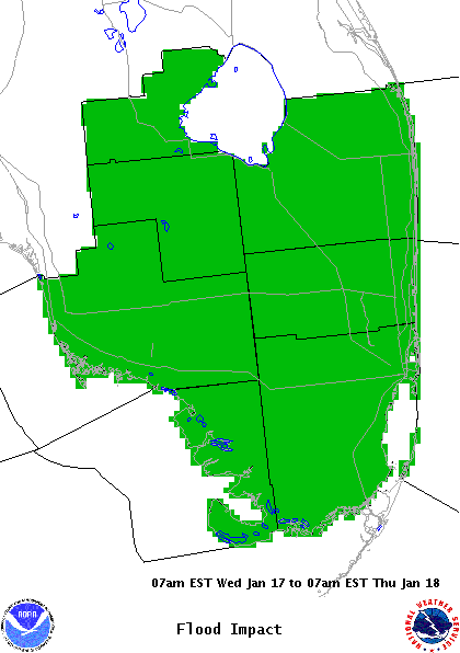
Tonight through tomorrow morning will probably be the wettest period of this new storms for South Florida. We'll keep you posted.


Potential Tropical Storm 18

A Tropical Storm may brush South Florida this weekend

A Tropical Storm Watch has been issued for Coastal Areas of South Florida from Craig Key in the Upper Keys to Golden Beach in SE Broward County..
.

There is an area of clouds and rain that practically takes up much of the western Caribbean Sea. It is dumping rain from Central America, to the Cayman Islands, Jamaica and Cuba. Some of this rain is forecast to move over us this weekend.

A recon plane found that the disturbance has become a depression  Earlier, NHC had deemed this a Potential Tropical Cyclone.


What is a Potential Tropical System?
This process of issuing advisories before a storm actually develops, is new.  NHC now has the option of starting advisories on a storm that has yet to organize. This gives areas in the storm's path the chance to prepare.  This new advisory  is known as Potential Tropical Cyclone.

The latest thinking on this Depression, is that it remains large with plenty of moisture, capable of heavy downpours. The 30 - 35 mph winds that have been clocked at times with this disturbance appear to be mostly on the southeastern side, down by Central Cuba.


This big mess will continue to move in our direction, and could still become a tropical storm later in the day.  It has a small window of opportunity to grow as strong upper winds ahead of a front may cut in down to size by Sunday.

Lots of uncertainties
The disturbance is still capable of heavy rains that could lead to flooding, land and mudslides over the Cayman Islands, Cuba, and the Bahamas. 

For South Florida the impacts should be in the form of possible heavy downpours.

This what NHC thinks:

The Cayman Islands, western and central Cuba, northern Bahamas: 4 to 8 inches with isolated maximum totals of 10 inches through Sunday. These rainfall amounts may produce life threatening flash floods and landslides. South Florida, including the Keys: 2 to 4 inches with isolated maximum totals of 6 inches through Sunday. These rainfall totals may produce flash flooding, especially in urbanized areas. WIND: Tropical storm conditions are expected to first reach the warning area in Cuba later today and the northwestern Bahamas tonight. Tropical storm conditions are possible in the central Bahamas tonight or early Sunday. TORNADOES: A couple of brief tornadoes are possible across far South Florida and the Florida Keys from midday through this evening.


The bottom line is just be aware that there is a possibility of heavy rain that may cause flooding. You can monitor the Live Radar here:


dsfsdf


Thursday, October 5, 2017

Tropical Storm Nate

A new storm develops in the Western Caribbean Sea and its name is "Nate".

On Thursday morning, "Nate" was just offshore the Nicaraguan coast with top winds registered at 40 mph. It is moving northwest under 10 miles per hour and should impact coastal Nicaragua and Honduras throughout the day.


It should dump plenty of rain across the region:

  • Honduras and Belize can expect 2 - 5 inches with isolated areas getting as much as eight.
  • Eastern Yucatan may see between 4 - 8 inches with some areas as much as 12.
  • Costa Rica and Panama are forecast to get between 5 - 10" with isolated areas up to 20".
  • Nicaragua will see huge downpours of 15 - 20 up to 30 inches in accumulation which will surely lead to flooding , land and mudslides.


Where is it going?
Tropical Storm "Nate" is very close to land and that should keep its growth process in check until it gets into the Gulf of Mexico over the weekend. While the waters here are not has hot as they were a month ago, there's still plenty of juice to elevate "Nate" to hurricane status on Saturday/Sunday.


The models on Thursday, shifted the cone a little further west as the strong upper level winds that were supposed to nudge east will arrive later than anticipated. This now places the area from Pensacola west to SE Louisiana in the cone of concern. Keep in mind this red area only represent where the eye may be at that time. Impacts can be felt hundreds of miles away from the center.