Tuesday, August 30, 2016

Depression 9 to aim for Central / North Florida

You've drop off your college student in one of our central / north Florida universities and you thought you just had to worry about tuition. Lo and behold, Mother Nature wants to add a little worry to the mix, as if you don't do enough of that already.

Trouble maker Tropical Depression 9, out in the middle of the Gulf of Mexico wants to make a U-turn and head to Florida. It may be anywhere between Tampa and Tallahassee, by the end of they week.

Satellite View:
As of mid morning Tuesday, it keeps showing more of those red colors which represent plenty of heavy rain.

Its moving over very warm waters which should give it a chance to grow stronger. The morning forecast shows a land falling system near hurricane strength.

You'll also notice some wispy clouds moving clockwise on the west side of the system. This is shear, which should remain in place another 24-36 hours, and should keep it from growing any stronger.

Dry air is also near and should further assist in keeping it in check.

Where is it headed?
As it has been with this system since last week, its been a bear to forecast.

While models suggest it will get pushed back to Florida by an approaching from out of the north, it is presently on a westward path and moving slowly.

When and if it does get picked up by the front, it will make the turn and head for Florida.


Tampa Radar:
Kids in school in Southwest , Central Florida, or North Florida?

Some squally weather in the form of heavy rain and gusty winds should approach by Wednesday-Thursday.

NWS is calling for plenty of rain which could lead to some flooding of low areas.

There will also be a tornado risk from late Wednesday through Thursday.

Please remind your children NOT to go surfing during this foul weather. A storm surge will accompany the system which can turn deadly.


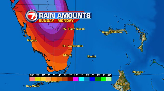
This is the latest information from NWS regarding possible rain totals for the event.


What to prepare for:
If all the models pan out, Thursday through Friday appear to be when the system will cut across from the Gulf to the Atlantic. It should be accompanied by pockets of heavy rain and some gusty winds in the 60-70 mph range. How widespread any or all of this will be still depends on the storm.

This is forecast to be near hurricane strength at tine of landfall which means, tree limbs will come down tearing away at power lines, and causing outages. Common sense rules apply. Make sure they have some water and non refrigerated foods, flashlights, charged phones and laptops. Above all, tell them NOT to go outside until the all clear has been given.


Sunday, August 28, 2016

NEW Tropical Depression #9

The area of disturbed weather known as Invest 99L, which we've been following for the last week, has finally organized. It is now Tropical Depression 9, and its still full on uncertainties.

Satellite imagery shows plenty of rain across the Straits just sitting there. Last Friday most models were shoving this rain over us this weekend, but that didn't happen.

This system has been a frustrating nightmare to forecast. First because of its indecisiveness and then because of its proximity to land and South Florida.

It has spent most of the weekend causing torrential rainfall over Cuba causing flooding there.

Earlier on Sunday, a recon plane went in to investigate the disturbance and, unlike other missions where no defined center of circulation was found, they hit pay dirt on this one.  NHC has classified it as Tropical Depression #9.

How strong will it be?
The models which we rely on heavily for guidance have been less than stellar with this feature. The most reliable models, the GFS and the ECMWF (European), have been at odds and mostly off. They have each called for intensification or weakening, or growth and dissipation at one time or another since last week.


The one thing the models were missing last week was a good starting point. No good starting point meant no good ending point, so they were giving us educated guesses. This time around they've got a good fix. So what are they saying now?  Still murky.

For the time being, strong upper level winds should hamper its growth but in around 48 hours the shear will relax allowing it to get a little stronger. BUT, its not that simple, the ECMWF says the depression should fall apart all together soon... with the GFS showing strengthening in 4 to 5 days. Most other models are being aggressive with its development. NHC is keeping its future strength as a Tropical Storm until the models give us more to work with. If it develops into a storm it will be called  "Hermine".

Where is it going?
Here too there is plenty of uncertainty. High pressure over the Atlantic will push it west into the Gulf, but that high should weaken and retreat in about 48 hours.


This will allow the system to stop and head north over the Gulf of Mexico.

What interaction will the warm waters of the Gulf have on its intensity is not too clear, but past history indicates a good window for strengthening.

In about 4-5 days a front out of the Nation's midsection dives into the Gulf pushing the system back to Florida.

This means, the entire state could see a huge drenching from tropical moisture dragged up from the Caribbean Sea.
We might have lucked out here in South Florida this weekend with drier conditions, but our luck may run out in the days ahead as all that moisture gets pushed here.


We'll keep you posted.


Thursday, August 25, 2016

Low still alive, still a concern

The broad area of low pressure moving over Puerto Rico and Hispaniola keeps producing areas of heavy rain with pockets of gusty winds this morning, but there is still no defined center of circulation. It is basically centered Southeast of the Turks and Caicos Islands. Gale force winds of over 30 miles per hour were also detected to the north of Puerto Rico and US Virgin Islands.


Strong Upper Winds are keeping it in check, but they will relax over the next 24 hours. By the weekend conditions will be favorable for further growth. If it can survive until then, there's still chance it may become a depression or a storm. It should be near the central or Northwestern Bahamas at that time.

The enhanced satellite imagery shows the blob of rain slowly moving west-northwest.  Most of the storm activity is far from the actual area of lowest pressure.

It will continue dumping rain over the region leading to flooding, land and mudslides from Puerto Rico through Dominican Republic and Haiti.

Advisories for the Islands:
Puerto Rico: May see some street flooding but as of 8 am, no warnings have been issued.

Dominican Republic: Flash Flood and Landslide warnings for the provinces of  La Altagracia, Hato Mayor, El Seibo, San Pedro de Macorís, Puerto Plata, Monte Plata, Sánchez Ramírez and Espaillat.
Street Flood Advisory for San Cristóbal, Peravia, Azua, María Trinidad Sánchez, La Romana an Gran Santo Domingo.

Haiti: Rain as well with a good risk for flooding,but so far no weather alerts issued.

SE Bahamas: No rain yet but squally weather should move in later today. It will gradually increase through Friday. Expect some gusty winds from time to time.

Chances for growth:
Very warm waters lay ahead for this disturbance as it treks towards the Bahamas, this is the reason why NHC is keeping the chances for development high. Warm waters of 80 degrees and above, is the fuel these tropical systems need to grow.

Water temps in this area register between 85 and 90 F. It can develop anywhere in the area highlighted in red over 5 days.

Everyone from the Bahamas through South Florida should keep their eyes on this. The intensity forecasts vary greatly.

It may may be anything from a rainmaker to a tropical system in the days ahead.

Because of this uncertainty, we just can't pinpoint what its impacts may be. NHC is keeping its chances for development at 80%.

If it develops, where will it go?
Most models are in agreement it will continue to aim for the Bahamas and Florida. Two other hurricane hunter missions are planned for today.


The recon mission plan includes:

  • Find a center, if their is one
  • Detect wind speeds and pressure readings to confirm if it has gotten stronger
  • Provide atmospheric data to NHC for more accurate model runs

South Florida outlook:
Unfortunately this nail-biting scenario will play out until the low makes up its mind. This is what the local NWS office in Miami is telling us:

At this point, there is  enough confidence that deep tropical moisture will remain in place across the region, with continuing widespread showers and thunderstorms and possible breezy or windy periods through early next week. 

The extended forecast will continue to be adjusted as the scenario for the tropical disturbance becomes more clear with upcoming model guidance.

We may get a soaking. Some models place two day rain totals for our area at around 5 inches.

If this pans out it will surely lead to street flooding, specially in poor drainage areas. 

As we get more details, we'll pass them on.


Wednesday, August 24, 2016

Waiting is the hardest part

As we continue to see what the wave near the Leeward Islands decides to do, everyone across that region as well as the Bahamas and South Florida, is anxiously waiting. We've been on standby mode for what seems days and days.  At times the wave seems to be getting its act together and at others not so much.  As of Wednesday morning, it looks like its on its way to becoming either a depression or tropical storm. If it becomes a storm it will be called "Hermine" (pronounced her-MEAN).

So lets look at this wave:
As of late Tuesday night, the wave had developed a broad area of low pressure, the first step in becoming a depression. As of Wednesday morning, its acquiring more and more thunderstorms. This is yet another sign of growth, but it doesn't have the main feature, and thats a well defined center of circulation.  The satellite shows dark reds and oranges, these are the areas where we are detecting the downpours… but no spin yet. Regardless, NHC is upping its chances for development over 5 days to 80%.

A recon plane is set to check out the wave this morning. If it finds that elusive well formed center, then we'll have a tropical system on our hands.

This will finally give the models a good fix and starting point for their forecast tracks. It will finally give us a good idea of where it is headed.

As of Wednesday morning, its surroundings are not allowing it to organize as strong upper winds keep it in check. That could change at any time, specially if the upper winds relax. The broad low is moving west at around 15 mph.

Even if it doesn't develop, it will dump plenty of rain across the Leeward Islands, Puerto Rico, Dominican Republic and Haiti.

In the long haul, the Bahamas and even Florida could see heavy rain.

Puerto Rico is already under a flood advisory.

The radar out Martinique shows plenty of rain moving over the Butterfly islands and heading northwest.


If it does develop, where is it going?:


More and more models are coming in line suggesting a path towards the Bahamas and then near or on Florida. Until we actually get a center, these remain an educated guess.  How strong it may be while it nears us is still unknown. The European model places a storm, maybe even a Cat 1 at our doorstep by the weekend. Again even if it doesn't organize its capable of heavy rain. We don't need a hurricane for torrential downpours and flooding. Just look at the low that impacted Louisiana a few weeks back causing widespread damages.

What should we prepare for?:
The waiting is indeed the hardest part ( a la Tom Petty).

What I am doing to ease my anxiety is to double check my hurricane plan. I suggest you do the same. If nothing happens, it was just be a drill. If something aims for us then you are prepared.  I'll keep you posted.

Monday, August 22, 2016

Two Depressions & a Wave

Tropical activity is on the upswing as we are following three features in the Atlantic.

Tropical Depression "Fiona" refuses to give up as it churns away in the Mid Atlantic, still no worries to any landmass.

As of Monday afternoon, NHC was tracking Tropical Depression #7 in the Far Eastern Atlantic. By 11pm Monday night it was elevated to Tropical Storm "Gaston". There's also a vigorous wave nearing the Lesser Antilles.

Everyone from the Leeward Islands NW through the Bahamas and Florida should follow this one.


Lets begin with the latest Storm:
It is moving NW rather quickly and could become a Category 1 system over the next 24-36 hours.  This one should remain an open water system. (Good News)


A wave to watch:

This wave, sitting a few hundred miles to the east of the islands, appears to be getting its act together despite being surrounded by dry air throughout much of the day.

NHC is giving it a 60% chance it could become a depression or a storm over the next 5 days.

By midweek it should enter a more favorable area for growth with warmer waters needed for development.


The area highlighted in orange is where NHC thinks this wave may grow.

It can do so at anytime from the Leeward Islands, through Puerto Rico, Dominican Republic, Haiti, Eastern Cuba, and Bahamas.

Where it may eventually end up or how strong it may be is another matter.

Scenario One:

Long range forecasts suggest the Bermuda High will weaken and drift East, while at the same time a front will stall over the Southeastern USA.

The wave will look for the gap between the two and head north.

This will mean rain and breezy conditions for the Bahamas and Florida, specially if something organizes.

Scenario Two:

In this case, the high remains firm with the front across the southeast fizzling, thus cutting off any escape route for the system.

This could mean more of an impact for Florida if it does develop.

Arrival time may be anywhere from Friday through the weekend.


Models:

Below is the latest run of models. The issue until it organizes, is that there is no good center of circulation. The models need a good starting point in order to give us good forecast tracks. Without that much needed starting point they are just guessing. Because of this, NHC has a recon plane on stand-by for Tuesday. 


I'll keep you posted.

Friday, August 19, 2016

Wave to watch

There's plenty of activity in the Tropics as we head into the weekend. Tropical Storm "Fiona" continues to weaken as it heads Northwest in the Atlantic, a worry only to shipping lanes.

There is a wave storming off the west coast of Africa which NHC is already giving a 30% chance for organization over 5 days once it emerges into the Atlantic.

Then there's the feature we are really paying attention to, the one with the orange ring.

NHC is placing a 50% chance for development on this broad area of low pressure.

It appears it will continue to move west aiming for the islands.

Where can it develop?

It can develop anywhere in the area highlighted in orange over the next 5 days.

NHC says:
Its roughly 600 miles southwest of the Cape Verde Islands, moving towards the Caribbean at around
15 - 20 mph.


It has to overcome two obstacles for growth:
First Hurdle: This broad low, while trying to get its act together, has very little t-storm activity. It needs to ramp up the thunderstorm creation process if it intends to survive.


Second Hurdle: It is being impacted by dry air to the north giving it little moisture to work with. It may be able to break this grip in days 3 - 5 of the forecast cycle.


Models:

If it does develop, long range models place this disturbance near the Lesser Antilles and even near the Bahamas in about a week.

I must caution since nothing has developed, there is no good starting point for the models to use. No good starting point, means no good ending point. So at this stage of the game the models are giving us an educated guess.  

Its just meant to give everyone across the Lesser Antilles a heads up on what may be developing to the east.


Tuesday, August 2, 2016

Distant Wave means local rain

For the last few days we've been watching a wave make its way across parts of the Caribbean Sea dumping plenty of rain. Jamaica, Haiti, and Dominican Republic all have seen copious amounts of rainfall. Each country has enacted its own version of watches and advisories.

Satellite imagery:


As of Tuesday morning, Jamaica is getting the brunt of the wind and rain while conditions are improving for Haiti and Dominican Republic. 

It appears there is finally a low level center within this wave/broad low system.  
I believe they will find a Tropical Storm or at the very least a tropical depression.


Hurricane Hunters:

They are in the disturbance as of mid morning Tuesday. They should find at the very least a depression over the area.

This is their second attempt as Monday's mission was recalled just before penetrating the wave due to technical issues.

If it is called a storm, it will be named "Earl".

Where is it headed?:

Models remain in fair agreement that this system will head due west over the next few days.

It should impact Belize and the Yucatan Peninsula with gusty winds and plenty of rain. This will lead to flooding, land and mudslides across the region.

I'm sure advisories will go up for them shortly if this wave is elevated to storm status.

THERE IS NO DIRECT IMPACT FOR SOUTH FLORIDA.

If its not coming here, why the rain?
This wave, also known as INVEST 97,  has plenty of moisture with it and some of that is being spun out and sent to Florida.

On the water vapor satellite image, you can see where most of the moisture can be found. We are looking at the mid to upper levels of the atmosphere in this loop. The bright blues, greens, and reds are the wettest areas, while the brows are the driest.


Some of that moisture has splintered away over the last 24 hours, pushing rain here.  More of that moisture is set to swing away and keep us mostly cloudy, breezy, with a chance of anytime downpours through Wednesday.

We will continue to monitor this INVEST, and wait for the recon data. I'll keep you posted.