Wednesday, August 31, 2011

Lee in the Gulf

The next system after Katia will be Lee. There is an elongated area of low pressure in the Gulf of Mexico with a real good chance it could become a depression over the next few days.

If it grows stronger and becomes a Tropical Storm, it will be named "Lee".  This area of clouds and rain in the Gulf has a 60% chance of developing over the next 48 hours. 

The big question with a tropical system so close to us, is... "where is it headed?".  The answer is up in the air... really.

We need to watch for some strong upper level winds moving into the region. They will dictate where this system will ultimately end up, the problem is, the models can't agree as to where and when the upper winds will appear.


As you look closely at the latest model runs, many take it North into Louisiana, others into Texas, and even some over the Panhandle.                         When models are this widespread, they really don't have a good handle on what is happening right now. We may need to wait another 12 hours for them to figure out what's going on and to deliver a more concise outlook.

Katia on the Verge

Tropical Storm Katia is nearing hurricane status this Wednesday morning. It remains a very symmetrical looking storm in the far Eastern Atlantic. Thunderstorm formation continues to build around the center of circulation and the potential is there for further strengthening down the road.

Katia is being pushed west by the Bermuda high and it should stay on this heading through late Thursday. At that time a gradual turn to the Northwest will happen. It should also slow down in forward speed.

So far it has been speeding west at around 20 mph.
We expect it to come down to around 10-15 mph over the next 48 hours.

New wrinkles have popped up this morning.

  • Dry Air: A pocket of dry air ahead of the system may keep Katia in check. Will keep watching it.
  • Wind Shear: While it remains minimal ahead of the storm, some models kick it up over the next few days, enough to have a significant impact on its intensity.


To the right is the latest model runs. They agree that Katia will get pushed northwest by the Bermuda high for about 5 days. By then, it should be within a few hundred miles of the Leeward islands. It could be a major hurricane by then.

In the long run, models also indicate strong upper winds will come out of the East Coast pushing the Bermuda high east. This will open a gap in the atmosphere for Katia to take.

Bermuda should keep their eyes on Katia as they could be facing a very strong hurricane by the middle of next week.

This is the official forecast cone from NHC out 5 days.


Tuesday, August 30, 2011

Katia getting Stronger

Tropical Storm Katia continues to intensify and should become a hurricane on Wednesday. It really looks good on satellite imagery and it could spin to major hurricane status by the weekend, if not sooner. Most of the thunderstorm activity has banded around the center of circulation and the wind speeds have picked up.


From the image to the right, you can see plenty of moisture associated with the system as t-storms surround the center.

The darker reds and oranges give you an idea of where the higher colder cloud tops are, this is where you will find most of the rain.

Outflow can be detected to the Southwest and Northwest sectors.


As of this writing, Katia will continue to move rather rapidly to the West-Northwest at around 20 mph. It will pass over very warm waters and little in the way of shear. Most forecasts place Katia Northeast of Puerto Rico as a Category 3 by Sunday.

Below you will find the latest suite of model runs. They agree that Katia will get pushed almost due west by the Bermuda high for about 5 days. By then, it should be within a few hundred miles of the Leeward islands. Models also indicate strong upper winds will come out of the East Coast and push the Bermuda high east. This will open a gap in the atmosphere for Katia to take.

It sounds simple enough, but a handful of models do not agree on the timing of this path to open, and it may travel farther west. If this happens, the Lesser Antilles may need to follow Katia a bit more carefully.

In the long run, the East Coast and Bermuda may be dealing with it.


This is the official forecast cone from NHC out 5 days.


Monday, August 29, 2011

Katia Next?

NHC is watching Tropical Depression 12 in the Far Eastern Atlantic. Conditions will become favorable on Tuesday for this it to become Tropical Storm Katia. (This is the name that replaced Katrina in 2005).
On the image to the left, you can see three features on the Satellite picture.
  • Upper right is an area of disturbed weather-nothing to worry about.
  • Over Africa, there is another good looking feature. Could be something to watch in a few days.
  • Lower screen is T.D. 12. NHC is confident it will get stronger in the days ahead.


Long range models like the CMC, show a well organized cyclone in about 5-7 days northeast of the Leeward Islands. High pressure (Shown in orange) will push the system (shown as a small green circle) northwest .

By the middle of next week, it could be a category 2. You will notice by then the high weakens and opens a road for Katia to take. We are hoping it will remain an open water storm.


The GFDL model also shows a good looking tight cyclone, northeast of the Leeward Islands in about 5 days.

Here too, the model develops a gap in the high that "Katia" should move through and hopefully avoid all land areas. 

Bermuda should keep their eyes out, just in case.

I'll be watching the progress of TD 12 tonight and tomorrow and see if it develops into Tropical Storm Katia.


Friday, August 26, 2011

A Close Call

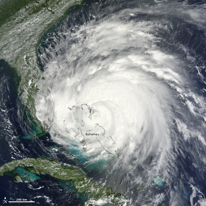
Irene came way too close for comfort in South Florida. Friday morning, this huge monster of a hurricane, with category 3 winds of 115 mph sat a mere 200 miles offshore.

It battered Puerto Rico and Hispaniola as a minimal hurricane earlier in the week, plenty of rain, winds, and flooding there. Unconfirmed reports now attribute two deaths in Haiti to Irene. Even Eastern Cuba had a push of waters as highs seas pummeled the coast.

Reports are still sketchy about injuries or damages from the Bahamas as many places are still without power . I am sure the Central and Northwestern Bahamas will report some serious damage.

Irene next to So FL early Friday morning

As most models predicted, our impacts here were light. Here is a small rundown:

  • Marine: Choppy Seas and high surf, a risk of rip currents remain
  • Rain: Many areas along the immediate coast of Northeastern Broward County, Deerfield Beach and Pompano Beach to name a few, saw between 1.5 to 2"
  • Miami Dade had some locations with as much as 1".
  • Wind: Very minimal. From Homestead through Key Biscayne, the entire coastline north through the Broward Palm Beach county line had wind gusts of up to 45 mph.
All in all, we were very fortunate not to have this monsters here.

Last word this morning,  there could be as many as 30 million people under watches and warnings across the East Coast as Irene aims for them. . (( I just heard on a news channel that NewYork through Massachusetts has only been hit by a hurricane, 5 times since 1851. I'll have to confirm that... but it sounds impressive.)))

A few storms come to mind right away when talking about the Mid-Atlantic. The most notables:

Hurricane Fran in 1996, which struck near Wilmington as a Category 3
Hurricane Emily in 1993 brushed the Outer Banks also as a Category 3
Hurricane Floyd in 1999,was the deadliest with 35 deaths.

But for a similar path, we compare Hurricane Gloria.

Gloria heading to the Outer Banks
Gloria, was a powerful Cape Verde-type hurricane that formed in 1985 . It reached Category 4 status on the Saffir-Simpson Scale near the Bahamas, but weakened significantly by the time it made landfall on North Carolina's Outer Banks.

It then hugged the coast and made a second landfall on Long Island, and, after crossing the Long Island Sound, it made a third landfall in Connecticut.

Overall, the storm caused $900 million in damages along the coast ($1.84 billion in today's value), and was responsible for eight deaths.  It was the last storm to hit the northeast until Hurricane Bob during the 1991 Atlantic hurricane season.


Hurricane Bob getting ready to hit Massachusetts
New England hasn't felt the impact of a hurricane in over 20 years, that may change this weekend.

The last was, Hurricane Bob, one the costliest hurricanes in New England history.  It first brushed the Outer Banks of North Carolina then moved north-northeastward getting stronger until reaching winds of 115 mph (cat 3).  Fortunately, it weakened slightly as it approached the coast of New England.

Bob made landfall twice in Rhode Island as a Category 2 hurricane, first on Block Island and then in Newport. Bob was the only hurricane to make U.S. landfall during the 1991 season..

Bob's wrath totaled approximately $1.5 billion (1991 USD, $2.42 billion 2011 USD) in damages. In addition, seventeen fatalities were reported.


Thursday, August 25, 2011

Irene

Good afternoon, after many long hours last night following Irene, I feel better for us today. Right now it is basically at the same Latitude as South Florida and moving Northwest. It would take a miracle for the center of Irene to stop on a dime, head due west, and impact us directly. Whew, we have dodged a huge bullet.

Our friends in the Bahamas have not been so lucky. We continue to get sporadic reports of structural damages through the Southeastern Bahamas, and hardly any info from the Central Bahamas.  This is obvious since the eye went over the area last night.

Massive power outages are common place, many trees down and I'm sure once reporters can go in and asses the situation, I believe the destruction will be impressive. Still hoping for the best.

I have not received any updates since last night from my contacts in the Bahamas. I am re-posting the last ones I received.


 Mr. Knowles stated:


Here is the present situation:


  • NHC is having a hard time determining if indeed Irene has replaced it's eyewall. Overnight its top winds dropped from 120 to 115. The downturn was attributed to this process.
  • The wind field has grown this afternoon.
  • Recon planes did confirm the much anticipated turn has happened.
  • Strong upper winds coming off the Southeast US, will push Irene east but not as far as the models thought yesterday. This places the Carolinas, right in the middle of what can be a very powerful and destructive strike.
  • The atmosphere is still primed for further strengthening for Irene. 
  • Some shear may interact with it in a day or two, but since Irene is so large and strong it may not be enough to weaken it before it hits the Middle Atlantic States.

Our local impacts today will be minimal compared to our neighbors to the east.

As seen on radar below, we will get some of the feeder bands coming through from time to time. While we wait for them to arrive, conditions will mostly cloudy and breezy. As the squalls move in, the winds pick up , as strong as 40 mph. Heavy localized rain. Choppy seas, with some beach erosion, and rip currents. A tropical storm watch remains in effect for boaters, NOT FOR ANY LAND AREA.

After Irene leaves the area, we will see our winds veer out of the southwest. This should bring us only isolated showers, but will pump up the temps as it draws heat and moisture from the tropics. Expecting highs to climb into the mid 90's from Friday through the weekend. Could even see  some records.

I have left the radar full screen so you can follow the feeder bands as they come in.
Barring any last minute surprises, this will be may last update on Irene for South Florida. Thanks for reading, and biting your nails, along with me through this scare.

Irene

UPDATE 8 AM: The storm is at LAT 25.5N LON: 76.5W or basically parallel to Miami. At its present speed and movement the center will miss South Florida. We can expect some gusty winds at times, on and off rain, and very rough seas. Whew!  Now a worry for the Mid Atlantic States.

UPDATE NHC 5AM: Irene bashing NW Bahamas and then heading to the Carolinas. NO Watches for us. Still, with such a dangerous hurricane a mere 225 miles to our East later today... keep watching just in case.

It is down from 120 mph to 115 mph as of this early update. The reason for this: It is going through an eyewall replacement. Imagine if you we running at full speed for as long as you could, sooner or later you have to catch your breath before taking off again... this is what the eyewall is doing, catching its breath.

Most models expect some strong upper winds to move off the Southeast coast today and protect us from Irene.

This is the latest from NHC at 5am:

  • THERE HAS BEEN NO CHANGE TO THE TRACK FORECAST REASONING.  IRENE SHOULD TURN NORTHWARD AS IT MOVES THROUGH A BREAK IN THE SUBTROPICAL RIDGE
  • THE OFFICIAL TRACK FORECAST HAS BEEN SHIFTED VERY SLIGHTLY TO THE WEST OF THE PREVIOUS ONE AND IS ROUGHLY IN THE MIDDLE OF THE GUIDANCE ENVELOPE...WHICH IS BRACKETED BY THE U.K. MET. OFFICE MODEL ON THE EAST AND THE GFDL MODEL ON THE WEST.
  • A HURRICANE HUNTER AIRCRAFT INVESTIGATING IRENE A FEW HOURS AGO FOUND THAT THE CENTRAL PRESSURE HAD DROPPED TO 950 MB. 
  • SINCE THE ENVIRONMENT APPEARS TO BE CONDUCIVE WITH WEAK SHEAR...WARM WATERS...AND AN UPPER-LEVEL OUTFLOW ANTICYCLONE OVER THE HURRICANE...THE OFFICIAL FORECAST SHOWS RE-STRENGTHENING WITHIN A DAY OR SO.  
  • GIVEN THE LIMITATIONS IN OUR ABILITY TO PREDICT INTENSITY CHANGE...THERE IS SIGNIFICANT UNCERTAINTY AS TO JUST HOW STRONG IRENE WILL BE WHEN IT NEARS THE EASTERN AND NORTHEASTERN U.S. COAST. 
We can expect breezy to windy conditions at the coast, with some pockets of rain. Sustained winds should be around 30 mph with some stronger gusts.  Going to the beach or boating is NOT recommended.

By tonight still a few storms, then by Friday look for hotter temperatures to move in here after Irene has passed.Keep your fingers crossed.


Irene


Like many of you I am worried seeing such a huge and powerful hurricane sitting so close to South Florida. Just a mere 350 miles east sits a Category three monster. It has already caused plenty of damage along the Central and Southeastern Bahamas.

It will continue to pack a punch as it moves over the Northwestern Bahamas.

It is undergoing an eyewall replacement and will continue to wobble overnight. This is typical for hurricanes as they never travel in a straight line so this little jog is to be expected.

Most models expect some strong upper winds to move off the Southeast coast tonight and protect us from Irene.


I trust these models, but I also remember 2004 when Hurricane Charlie was headed to Tampa and within hours grew into a major storm and impacted SW Florida instead.


The latest suite of model runs still keep Irene away from us heading to the Carolinas and then the Northeast.


This is how NHC is looking at it.


  • THE EYE OF THE HURRICANE HAS BEEN MOVING NEAR OR OVER SOME OF THE BAHAMAS RESULTING IS SOME WOBBLING. 
  • THE DEVELOPMENT OF THE LARGE TROUGH ((Strong Upper Winds)) ALONG THE EAST COAST OF THE UNITED STATES IS MATERIALIZING AS PREDICTED BY THE GLOBAL MODELS.
  • THIS STEERING PATTERN WILL FORCE IRENE TO TURN TOWARD THENORTH-NORTHWEST AND THE NORTH WITH A SLIGHT INCREASE IN FORWARD SPEED OVER THE NEXT FEW DAYS. 
  • THE LATEST GUIDANCE HAS CHANGED VERY LITTLE...AND PERHAPS THE ONLY DIFFERENCE IS THAT THE GFS SHIFTED 30N MI TO THE WEST...TOWARD THE ECMWF SOLUTION DURING THE LAST PORTION OF THE FORECAST. 
  • THIS DOES NOT RESULT IN A SIGNIFICANT CHANGE OF THE OFFICIAL FORECAST TRACK FROM THE PREVIOUS ONE.


I don't know if that makes me feel any less uneasy. I will get a few hours sleep and wait for the next big advisory at 5am.... Hope for the best.


Saturday, August 20, 2011

Irene

Nasty night for Central Bahamas as they are starting to get 120 mph winds with stronger gusts all across the area. 100 mph winds were just reported in George Town. Earlier the Southeastern Bahamas got hammered, initial reports talk of many houses and buildings with roofs lost and widespread power outages. Even though all models say it should miss us... please keep an eye on Irene just in case it takes its sweet time turning. IF that happens we may get more of Irene than we really want.

This tropical machine is firing on all cylinders with plenty of hot ocean water to feed it and impressive outflow in the upper levels.

Even though we are not in the cone of concern, we will feel some of Irene's wrath. we may get some gusty winds, pockets of heavy rain, and rough surf.


  • Wind: By Thursday, it will be breezy with winds up to 30mph and some stronger gusts.
  • Rain: We could see some of Irene's feeder band dump pockets of rain... but they will be fast movers.
  • Surf: Choppy seas. Late Tuesday afternoon NWS added a Tropical Storm watch for coastal waters from Jupiter Inlet south to Ocean Reef. IT IS NOT FOR LAND AREAS. The advisory is to alert boaters not to venture over the Coastal waters as Irene approaches.

These are a few things we should watch out for:

  • Further intensification:  Yes, things could get worse for our friends in the Bahamas. Conditions remain favorable for it to reach cat 4 (winds of 131mph+) by Thursday.  After that, it will juggle between a cat 3 and 4, as the eyewall is replaced . When systems are this powerful, its like a runner sprinting in a marathon, it can't do it, so it slows down to recoup, weakening,  and then it runs off again at full speed. This is why the eyewall gets replaced.
  • Will it make a turn?: That was something I had been looking for through all the recon data. Hurricane hunters now say it has begun turning more northwest, staying clear of Florida but still aiming for the northwestern Bahamas.
  • East Coast worries: That's the next issue. The longer its delayed over the Bahamas, the more time strong upper level winds in the Nation's mid section can move to the coast and hopefully block Irene.  Right now, models are split on this decision with some keeping Irene over land and others pushing it out to sea

To all our viewers with friends and family in the Bahamas, our prayers are with you. I presently have a team member scouring any and an all info we get from the Bahamas and will air what we get on our weather segments. Of course 7News has a team of reporters in the Bahamas to keep you up to date as weather permits.

For residents here with friends and family in the Middle Atlantic States and the Northeast... keep a watchful eye on the cone. If it changes, we'll let you know.


Friday, August 19, 2011

Three in the Tropics, One to watch

Three tropical features are being watched right now, T.S. Harvey, and two good looking waves in the Atlantic. Activity is starting to pick up as we are now in Cape Verde Season and are headed toward the peak of activity come September.


We begin with Harvey.
Tropical Storm Harvey developed from T.D. 8. The biggest impact from this system will be the rain.


Most forecasts agree Harvey could drop anywhere between 3-5 inches and as much as 8 over high terrain. This should lead to flash floods, land and mudslides for Guatemala, Honduras, and Belize. Our thoughts are with them as we hope for the best. Below is the forecast cone regarding Harvey.


We now turn our attention to:
Wave number 1. It's the middle of the Atlantic Ocean with a better chance for growth.  Up from a 20% chance on Thursday, to a 60% chance today. It will continue to move through an area of the atmosphere with favorable conditions for development... but the terrain ahead will be a tad hostile.

This is a wave we need to watch carefully as long range models forecast a path impacting plenty of land masses along the way. It may eventually threaten Florida as well.

If it continues to get its act together, it may be a depression by the Lesser Antilles over the weekend.  It may move over Hispaniola,  and if it does, the high terrain there could have a negative impact on the system weakening it considerably. Unfortunately, it will dump plenty of rain over Dom. Republic and Haiti.


Wave number 2:
Has looked impressive on satellite ever since it emerged off the West Coast of Africa. From the very start NHC gave it a moderate chance for development and as of today that chance is high at  40%.

This satellite picture of the Far Eastern Atlantic, shows the good looking wave just South of the Cape Verde Islands. It appears to have cyclonic circulation already.

What's interesting to see from this picture is that there are at least two more "waves-to-be" right behind it over Central Africa.

This is where we look to this time of year for storm and hurricane formation. The good news, if there is any, is that we have plenty of time to watch them.


According to the models, this system should be a worry only for the shipping lanes.

It will find a weakness in the Bermuda high and steer away from the Lesser Antilles.

Unfortunately, it appears Bermuda may again be in the path of another storm down the road.

This feature is over one week away from them so they should have plenty of time to prepare.


Thursday, August 18, 2011

Maybe something, maybe nothing

This is the time of year when we look to the Cape Verde Islands for storm formation. Every year dozens and dozens of waves spin off the West Coast of Africa and only a handful develop into tropical systems.

We always keep a vigilant eye on the Eastern Atlantic just in case one of those waves decides to intensify and wreak havoc down the road.

On this Thursday, way out in the middle of the Atlantic, there is a tropical wave which NHC is giving a 10% chance that it could grow into a depression in the days ahead.  Right now it is just an area of clouds and rain with little in the way of wind and no center of circulation. We have seen worst afternoon storms here in South Florida than what this wave is producing at the moment.  The red circle in the Caribbean may turn into a depression later today and ultimately it will impact Central America. We are looking at the yellow area in the Atlantic.


There are times when technology shows us things that are still not there. Models offer us a glimpse of the future and can help us prepare in case something comes our way. Today, there is a great example of this.

Some models are already anticipating a depression forming in the open waters of the Atlantic and quickly developing into a hurricane.

The image below shows where this possible hurricane may be in 7 days. There is allot to look at here.  I have placed the image on large mode so we can see all the details.


  • The light gray lines define all the geography. You can find the USA and spot Florida.
  • The big orange areas represent high pressure systems, and the blues-low pressure.
  • Notice the tight circles highlighted by a blue dot right over Cuba. This is where the possible hurricane could be in 7 days, pushed our way by the Bermuda high to its East.


I would like to reiterate that as of this writing, there is nothing there in the Atlantic, not even an area of low pressure. For all we know, Mother Nature may fizzle this wave out as so many do this time of year, or then again, the worst could happen.  I wanted to show you this, just in case the models pan out and we have to deal with a hurricane in 7-10 days.  Let's hope nothing happens.

Monday, August 15, 2011

Monday, Monday

We begin the week with T.S. Gert bothering Bermuda. It should slide to its East today providing some gusty winds and maybe 1-3 inches of rain. NHC is also eyeing another area .

NHC has begun to reference again what was INVEST 93 last week. They reintroduce it with a small chance for growth right over the Windward Islands. Most models keep it over the Caribbean throughout it's lifetime.  Residents there should follow it just in case it develops.


Plenty of action took place over the weekend. We had T.S. Franklin come and go. Now we have T.S. Gert and two small contenders. Let's see what this week brings.


By the way, WSVN has a great hurricane tracker. Click on the link below for the latest. It is fully customizable with the latest cone, models, and satellite pictures.


WSVN Hurricane tracker

Sunday, August 14, 2011

Down to two

NHC is now following Tropical Storm "Gert" which developed out of  T.D. #7. A tropical storm warning is up for Bermuda. They should also be on the lookout for the orange area on the map below. It has a moderate chance of development and could also move their way in the next few days.

As of Friday night, there were four features in the Tropics, but now we are down to two. Mother Nature got rid of T.S. Franklin Sunday morning and totally erased another disturbance that could have been a menace for the Lesser Antilles.


By the way, WSVN has a great hurricane tracker. Click on the link below for the latest. It is fully customizable with the latest cone, models, and satellite pictures.


Saturday, August 13, 2011

Following Four

NHC is now following T.S. Franklin, T.D. #7 and two other features. The good news, the one that might have posed a threat to us down the road is falling apart.


Franklin is a minimal storm moving away from any landmass. It should only be a worry for the shipping lanes.

T.D. 7 should track near Bermuda in the days ahead. They should also be on the lookout for the orange area as well, as it appears it too could be heading there soon. 

The last system highlighted in yellow with a minimal chance for development, is the one we were keeping an eye on. If it were to survive and  strengthen, the models keep it moving west and near the Lesser Antilles in about 5 days. Too far away for a worry right  now, but still, it could eventually be a threat to the islands if it does grow into a tropical cyclone. I must note that as of this writing it looks highly disorganized and may be done by Sunday.

By the way, WSVN has a great hurricane tracker. Click on the link below for the latest. It is fully customizable with the latest cone, models, and satellite pictures.


WSVN Hurricane tracker

Thursday, August 11, 2011

Obiwan is on stand-by

In a Galaxy far, far away (sorry my kids are watching Star Wars for the umbillionth time) there are two disturbances. NHC is calling these two features in the Eastern Atlantic INVEST 92L and INVEST 93L.

Typically, these areas of clouds and rain are about 2 weeks away from us, assuming they actually develop and head for South Florida. The Force has to be with them. (couldn't help it).  They have to survive the Saharan Air Layer, which has been the doom of many systems this season, while at the same time avoiding hostile atmospheric Storm Troopers. (I mean strong upper winds).

92L is a few hundred miles Southwest of the Cape Verde Islands and promises some development down the road, but most long range models keep this system weak with a gradual turn to Bermuda.

The second system, 93L, just off the West Coast of Africa, is our Young Luke Skywalker. It has the potential to become a worry along the way. It appears to be moving farther South and away from the African dust. Models develop it into a storm that could, in around 5-7 days, threaten the Lesser Antilles.


I am hoping Yoda will "well teach 93L hmmm",  (Saying that last line with a Yoda accent may help) and show him the way away from any landmass. But Darth Vader and the Evil Hurricane Emperor are out there somewhere and they could stir things up as we move into the most active part of storm season.


Monday, August 1, 2011

T.S. Emily

Lessons learned:

Emily was a struggle to forecast from the very beginning. Last weekend conditions were so favorable for it to develop, that NHC gave it a 100% chance of becoming a depression. It never did.  Recon planes went out and could not find a center of circulation. Then ,when it appeared atmospheric conditions were becoming more hostile, it defied the odds and became a Storm.

It slowly made its way west from the Atlantic, over the Lesser Antilles, and into the Caribbean Sea dumping plenty of rain along its route.

Emily showed plenty of promise that it could grow stronger, and little by little the winds inched up until they capped off at 50 mph, then something happened. In spite of plenty of available heat energy from the ocean, little shear, and favorable upper atmospheric conditions, it never grew stronger. Hurricane hunters made repeated trips to find the center but it was very illusive. This became a major headache for forecasters at NHC because without a good fix on the center, all the models would have a hard time determining a future path. This was reflected in the cone shifting various times. 

Emily eventually came to a stop on Wednesday, and fears grew that it may finally be getting stronger, but recon again failed to find a defined center. The system however was loaded with  moisture and the skies opened up with plenty of rain across Puerto Rico, Dominican Republic, and Haiti.Some areas could end up with 6-10" of rain, some pockets as much as 20".

In the office, we saw most models kept taking Emily over Hispaniola. Some of the highest terrain in the entire Caribbean is found here. We wondered if Emily would survive a direct impact. Some models dissipated the system altogether, while others kept it alive and intensified it down the road. South Florida was kept in the cone in case Emily decided to throw us a curve ball, but fortunately, it struck out. With strong upper level winds ahead of it, dry air injected on its western edge, and a poor organized center, it finally came to an end Thursday afternoon.

There is still some moisture lingering over the area that will devastate parts of Hispaniola, and could in the long run, cause some rain for us over the weekend.

All in all, the staff learned, that even though conditions may say they are 100% right for a system to develop, it may not happen. We also learned that while many models predicted Emily getting stronger and only a few killed the system outright, we should never underestimate the lone model.
This is what NHC said regarding the lone model on Thursday:

THIS WAS A BIG WIN FOR THE ECMWF GLOBAL MODEL...WHICH NEVER DEVELOPED EMILY AND ALWAYS FORECAST DISSIPATION NEAR HISPANIOLA.


We are proud  however, that we showed the high peaks of Haiti and Dominican Republic and how they would weaken this system. We showed a wide variety of scenarios focusing from total dissipation to a possible strike over Florida.  Its never easy forecasting tropical activity, but I am blessed to have one of the best meteorological teams anywhere. I thank them for their input, knowledge, and creativity during this tropical season.