Tuesday, September 13, 2022

NEW Invest96L to keep an eye on

 The National Hurricane Center (NHC), is monitoring two areas for possible development in the Atlantic. One is worthy of keep an eye on as it could come close to So FL by early next week.


It has been deemed Invest96L by NHC. This is an area NHC would like to INVEST-igate further, 96 is a tracking number and "L" stands for the Atlantic basin. 


More showers and storms have popped up within this Tropical Wave. It's roughly 1000 miles East of the Lesser Antilles. NHC suggests that environmental conditions are slightly conducive for additional growth. A tropical depression may form over the next few days.The Leeward Islands should stay alert as it is moving their way.  It has a 40% chance for development.

Models


Very early spaghetti models, suggest a path near South Florida by early next week. Even if the wave does not develop into something stronger, there's a chance it could bring us pockets of heavy rain.  Since nothing has organized, there is no center to track it from. Models at this stage of the game are giving us an educated guess. 

This is a reminder we are still in hurricane season and we need to stay vigilant.  

The second area 

NHC is also keeping tabs on a second wave 

This one is near the Cape Verde Islands. Showers have diminished plenty and NHC has dropped its chances for organization from 20% to 10% over a period of 5 days. If it's going to develop it will do so in Yellow area.

We'll be watching


Sunday, November 15, 2020

2 Hurricanes in 2 Weeks

Parts of Central America are set to get hit by a second destructive hurricane.  Imagine getting hit by not 1 but two category 4 systems in a matter of weeks. This is what will happen to Nicaragua and Honduras as early as Monday.


The satellite loop shows a very healthy hurricane on its way to becoming a major system shortly. You can clearly see a center spin, with plenty of feeder bands, and some high clouds rotating in the opposite direction as the storm. This is known as outflow. 

Imagine the center of the storm as an empty tube of paper towels. Hot moist air enters at the surface or bottom of the tube, feeds the storm, and then exits in the upper levels or the top of the tube. If the tube is not bent or impacted by strong winds, the feeding process goes off without a hitch. The air at the surface spins in a counterclockwise rotation but by the time it exits at the top, its spinning in the opposite direction. This is outflow and it means Iota is running on all cylinders and its not good news for our friends in Central America.

Where is it going?

It will move ashore over the same area Hurricane Eta did on November 3rd. It impacted  Puerto Cabezas, Nicaragua with destructive category 4, 140 mph winds and flooding rains. Hurricane Iota will be an unwanted and unwelcomed repeat performance.

This is what is forecast:
Iota will approach Northeastern Nicaragua and Eastern Honduras possibly late Monday or very early Tuesday. NHC says it will be an extremely dangerous Cat 4 hurricane by then.

Rain Projections
  • 8 - 16" with up to 30" in spots - Honduras, Northern Nicaragua, Guatemala, Southern Belize. This will lead to major flooding, land and mudslides, over an area that is just in its infancy of cleaning up after Eta. 
  • 4 - 12" - Panama & Costa Rica  
  • 3 - 10" - Southern Nicaragua and El Salvador  
  • 1 - 3 with possible 12" is some areas of Northern Colombia.
Hoping for the best. We'll be watching.


Friday, November 6, 2020

So. Florida in the Cone

The track of Eta has it moving towards South Florida. It's forecast to make a turn west, but it will be a matter of timing whether South Florida sees a direct impact.


The latest:
  • The center of Eta is back over the warm waters of the Caribbean Sea
  • Plenty of rain across Belize and parts of the Yucatan Peninsula
  • It is now forecast to restrengthen
The system will continue to drench parts of Central America until it makes its way to Cuba by the weekend. The Cayman Islands are now under storm advisories as the system should track in their direction.

What Next?

Eta should become a Tropical Storm later today as it soaks up all the fuel from warm Caribbean waters. As it nears Cuba, it will run into high pressure sitting in the Western Atlantic. It will bounce off it and be sent west. When that bounce happens, will dictate when it makes the turn into the Gulf of Mexico.

Its intensity should remain in check. There are some strong upper level winds across Cuba that should keep Eta from gaining too much strength.  But keep an eye on it. This year many systems have intensified just before landfall. In any case, some tropical Storm watches/warnings may be issued as the system approaches South Florida.

Presently there is a Wind Advisory in place for Broward County from the Beaches west to I-95 and the same for Miami Dade Co, extending to the Turnpike in Southern Miami Dade. This runs thru Saturday at which time it may get replaced by tropical advisories. 

A Rain Event
The biggest concern with Eta will be the amount of rain it could drop. Expecting:
  • Cayman Islands: 10" - 20" inches with some areas as much as 30" 
  • Jamaica: 2" -  5" with up to 15" in spots
  • The Bahamas & South Florida:  5" - 10" with up to 15" possible along the East Coast 
Any additional rainfall over already waterlogged South Florida will lead to flooding. The National Weather Service has issued a Flood Watch for Metropolitan Broward & Miami-Dade thru next week.


Bottom line:
There's a tropical system moving our way. It may get bounced into the Gulf of Mexico, just unsure as to when it will happen. Even with no direct impact, heavy rain is forecast to move over South Florida.  The radar below is live to help you keep track of the rain.


We'll be watching


Thursday, November 5, 2020

Now we Watch

Weaker Eta still dumping rain across Central America. Now Cuba, South Florida and the Bahamas wait for its second act.


Eta still has a broad spin but it is quickly losing all the checkmarks of having "depression" classification. It should become a a regular area of low pressure later today. It will continue to drench many areas across Central America.

What is Next?


  • Models indicate that high pressure steering Eta west is leaving the area and moving back into the Atlantic. 
  • Another spin developing in the Gulf, but in the upper levels of the atmosphere, will begin to push Eta back into the Caribbean Sea.  Eventually Eta will re intensify into a tropical storm. 
  • The track suggests it will cut across Cuba, and as it enters the Florida Straits, it will hit the high pressure system now sitting across the Bahamas. Depending how early or late this bounce happens, will determine where Eta will end up.
  • The center of Eta could be anywhere inside the cone, not just where the storm symbol is situated.

Its intensity is being set at Tropical Storm, but be ready just in case it decides to get a little stronger on its arrival.

Even if the system arrives weak anywhere near So Florida, it is still capable of heavy downpours that will lead to the threat of street flooding.  NWS may issue a flood watch as their models show the potential for anywhere between 7 to 10 inches.


Please stay alert.


Wednesday, November 4, 2020

Weaker Eta, still packing a punch

Eta Weakening but remains very dangerous

Eta is moving over Northeastern Nicaragua, still looking good on satellite imagery, but its rains have decreased in intensity. It will continue to lose organization over the next two days as it travels over land. 

The experts at the National Hurricane Center (NHC), say Eta should become a regular area of low pressure in 48 hrs with the surface spin almost gone. The upper spin however, should remain intact. 

What it means: Imagine a full roll of paper towels. The tube in the middle is the center or the eye, and the paper towels represent the rain bands. The paper towels are being used and getting tossed but not all, and the bottom part of the tube has been cut off by the ground, but the top part of the roll remains. This upper part is forecast to regenerate the bottom once over the warm waters of the Caribbean Sea.

While Eta's downpours have decreased, it's still dropping plenty of rain across Northern Nicaragua, Honduras, Guatemala, and Belize. The threat of flooding, land & mudslides are present even for Yucatan Peninsula, and El Salvador, as well as, Haiti, Cuba, & Cayman Islands.

What Next?

If Eta can survive its interaction with land, this is what may play out. Three features are set to determine Eta's path:

  • An upper low developing over the Northern Gulf of Mexico
  • Jet stream over the U.S.
  • High pressure in the Western Atlantic Atlantic.

An Upper Low, is an area of low pressure spinning counter clockwise. It will start to nudge Eta towards the northeast and into the Caribbean over the next few days.  The jet stream is a river of very strong gusty winds moving west to east. It will eventually add an even stronger push to Eta, sending it in our general direction. High pressure is just east of the Bahamas and will act as a road block to Eta, keeping it in our vicinity. 

This scenario spells more rain for the Caribbean Islands and then possibly South Florida / NW Bahamas.

At the moment, forecast models do not show it any stronger than a storm if it gets to South Florida. But as you know, intensity forecasting is extremely difficult. You have seen how quickly storms have grown as they near land this year, so keep that in mind.

What is possible

As the above three features start to come into play, plenty of tropical moisture will get drawn into South Florida on Thursday and Friday. This will lead to the possibility of heavy rain leading to flooding. The area could see downpours through the weekend. After that, it all depends on Eta's path. If it swings towards the Northern Bahamas, we may see less rain, if it moves over South Florida or even the Eastern Gulf of Mexico, we will see even more downpours.

This system in the month of November is a reminder that hurricane season is not over. As a matter of fact, hurricane season is a man-made timeline. Systems can brew at anytime of year as long as water temps are 80 degrees or above, this is their fuel. Typically sea surface temps are at their warmest from June through the end of November and thus, we call this hurricane season.

When and if watches and warnings are issued for South Florida, you should act accordingly.


We'll be watching 


Friday, September 11, 2020

Tropical Depression 19

South Florida is under a Tropical Storm Watch and a Flood Watch

Twenty four hours ago, this disturbance over the Bahamas had a mere 40% chance for development and that was expected once it moved into the Gulf of Mexico. Yet at 5 pm Friday, the National Hurricane Center (NHC) began issuing advisories on tropical depression 19.


The depression will track over South Florida Friday night and move into the Gulf of Mexico. Once there,it could turn into tropical storm Sally and aim for the Gulf States.


The area shaded blue is under a tropical storm watch. This means that between tonight and Saturday, winds over 39 mph are POSSIBLE. Not a certainty, put the possibility is there with this depression.


Heavy rain is the biggest concern with TD 19. Up to 4 inches are possible in some areas and that could lead to street flooding. All of South Florida is under a Flood Watch.


We'll be watching.

96L Close to Home

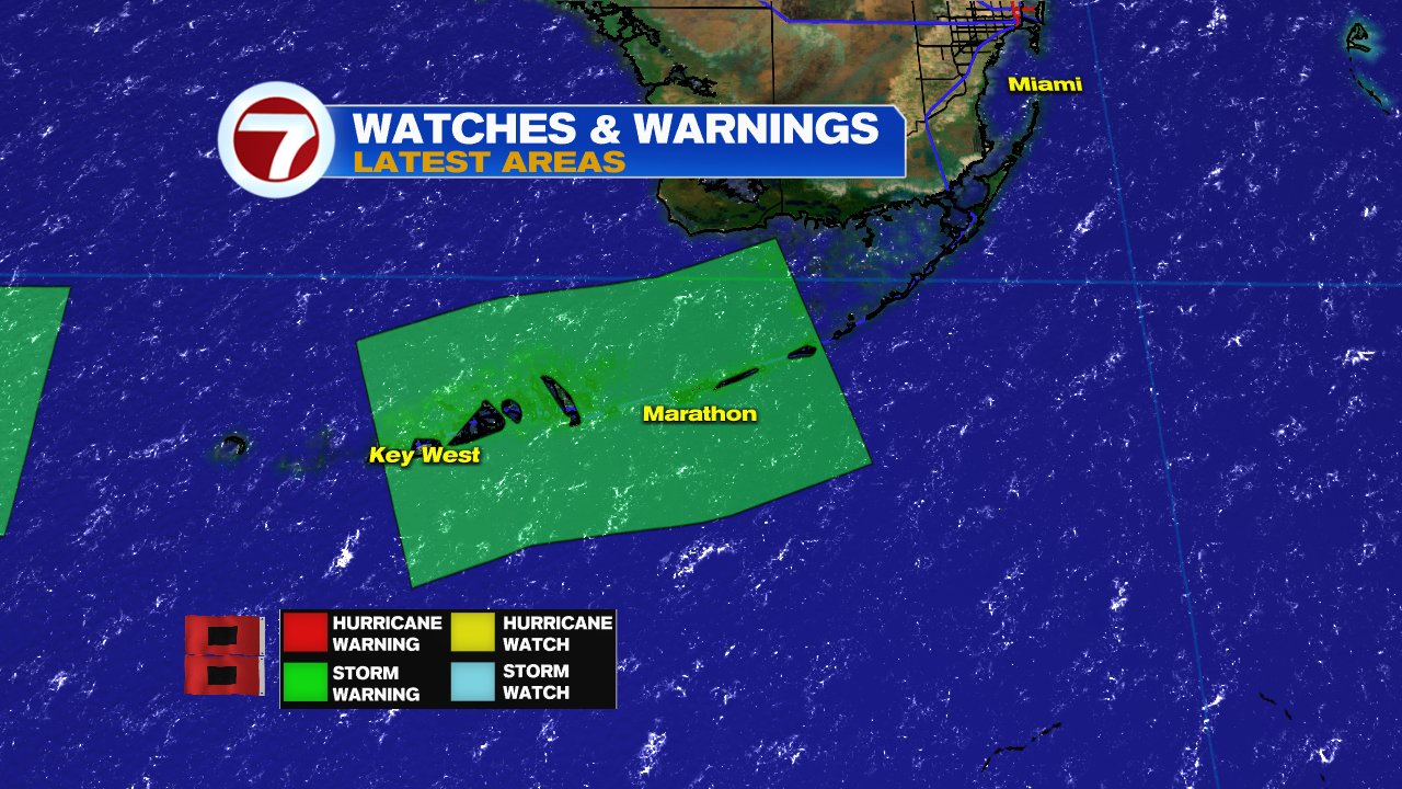
Friday brings us a healthy disturbance over the Northwestern Bahamas. It is being watched by he National Hurricane Center (NHC) and is forecast to cause pockets of heavy rain across the region. It could become a depression as early as tonight

Satellite Loop


This is Invest96L. Invest for an area NHC is INVEST-igating, 96 is a tracking number, "L" stands for Atlantic Basin. It could become a depression near South Florida Friday Night.

  • Location: Over Northwestern Bahamas 25.0 N 78.0 W 
  • Winds: Gusts at times to 30 mph 
  • Pressure: 1013 mb / 29.91 inches 
  • Moving: West at 10 mph

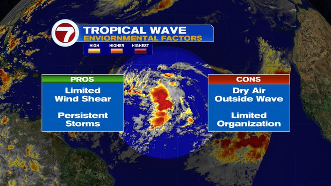
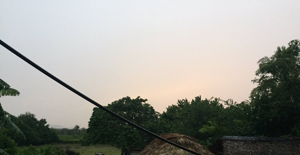
The darker oranges, browns, and even black colors in this loop will show you where the highest cloud tops can be found, which correlate to heavy rain. 96L appears to have plenty of moisture which will be impacting the Bahamas Friday.  Some of the rain should start creeping into South Florida by late afternoon and stay over the area possibly throughout the weekend. Saturday could be a wet day with possible street flooding over areas saturated from recent rain.

NHC Watching 6 Areas


This is a great view of five out of the six systems NHC is following.
  1. Small bit of clouds just west of Florida is a disturbance 
  2. Big blob of clouds over the Bahamas is Invest96L 
  3. Swirl in Mid Atlantic is Paulette 
  4. Smaller spin SE of Paulette is Rene 
  5. Big mass of clouds off Africa is Invest95L. 
  6. Not seen from this angle is a new wave over Western Africa.

Chances for development of 96L:

Look at the orange"X" by the Bahamas. NHC says the disturbance has an 80% chance for organization. Surface observations suggest it could become a depression late Friday. If it doesn't, it should once it moves into orange area in gulf of Mexico. An area of low pressure could be forming already. 

Where is it headed?


Early model runs suggest a track that may take it as far East as Florida's Big Bend and as far west as Eastern Texas. This entire region should monitor it closely. 

Live Radar


Stay on top of the downpours with LIVE radar from NWS Miami.

Another Disturbance near Florida


On this satellite view, the disturbance is not the big blob of clouds over Texas, but the small strip just south of Mississippi & Alabama. Per the potential formation graphic earlier in this post, it has a 30% chance for development as it drifts SW into the yellow area away from Florida.

2 Tropical Storms

Paulette


Paulette should intensify into a hurricane this weekend and unfortunately aim for Bermuda before making a sharp turn back out to sea. This turn will be due to the jet stream and a high pressure dome coming out of the U.S. We hope this duo speeds up to offer Bermuda some protection.

Rene


Rene will get lost in the steering winds the next few days. It is battling shear and moving over the same territory Paulette traversed. This water is spent of its fuel, not as warm, and thus provides no energy to Rene. 

Where to Next?


If it survives the weekend, it will eventually start moving north again being dragged by the same jet that pushed Paulette Away.
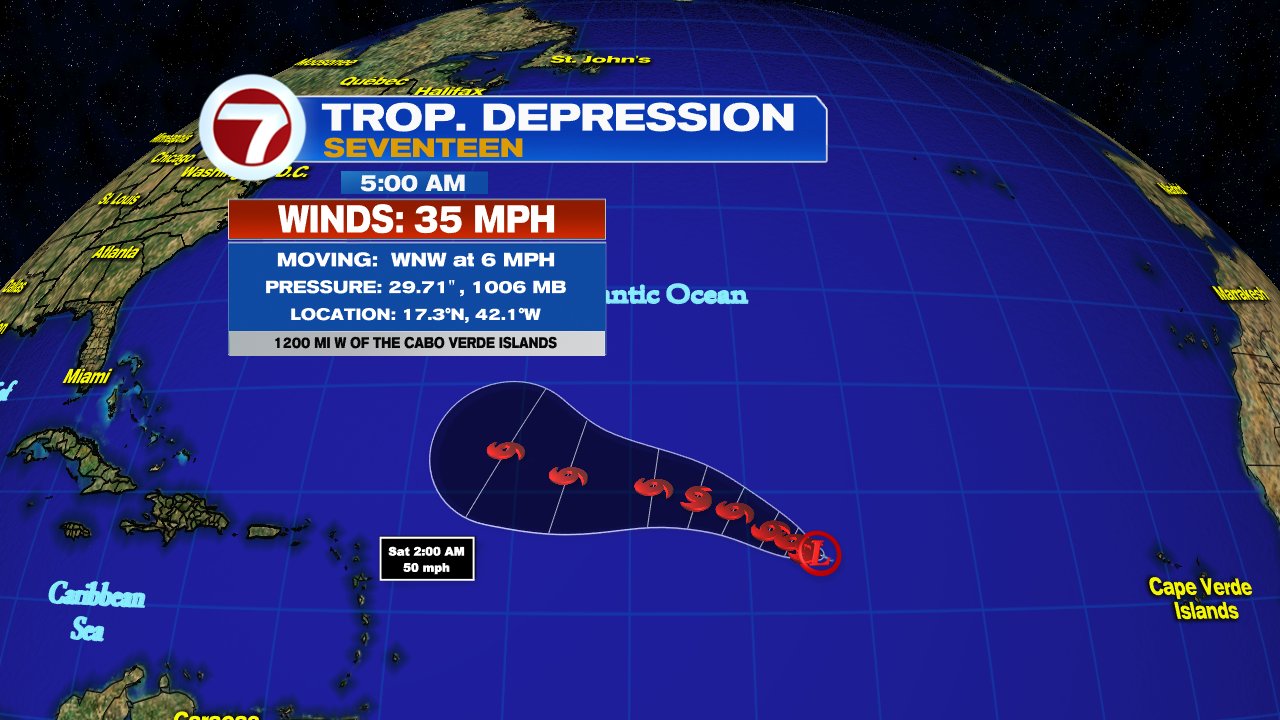
Invest 95L


If you refer to the potential formation graphic at the start of the blog, you will see a big red swath in the Eastern Atlantic. This is where 95L is expected to develop. It has a high chance, 90%... that it will become the next named system 

  • Location: A couple of hundred miles South of Cape Verde 11.0 N 25.0 W 
  • Winds: Gusts at times to 30 mph 
  • Pressure: 1011 mb / 29.85inches 
  • Moving: West at 15 - 20 mph

Where is it headed?


When you see a model spread like this, it means they are having a tough time with 95L. Some runs take it towards the islands, while other move it quickly to the north Atlantic. Lets see what actually develops and where, so the models can get a better handle. This is so far away, there is plenty of time to watch.

Lastly, a wave over the West Coast of Africa.

It is just starting to emerge over the Eastern Atlantic. Once in the orange area by Cape Verde, as shown in the potential graphic, it will get a 40% chance for growth.


Lots to watch, and we'll be watching.


Thursday, September 10, 2020

Peak of Season, Lots to Watch, & La Niña

September 10th is the peak of hurricane season. This is the time of year when we tend to see the most activity in the tropics, and as we look out into the Atlantic Basin we can see why.

Thursday morning the National Hurricane Center (NHC) issued its Tropical Outlook, or areas they are monitoring, and the tally is 7.

Lets look at them one by one:

  • Yellow X by the Carolinas- Is a disturbance with some shower activity that is expected to fall apart soon. Good news here. 
  • Yellow X East of the Bahamas- is an area of clouds and rain that will move over the Bahamas & So. Florida over the next 24 hours, with the possibility to deliver more rain. Once it moves into the Gulf it will have a chance to develop as it moves away from us. 
  • Yellow X in Gulf of Mexico is new as of Thursday morning,  Small disturbance moving SW. It has a low chance for development over the next 5 days.  
  • In the middle of the Atlantic we find two Tropical Storms, Paulette and Rene. No worries from Rene but Paulette could impact Bermuda by Tuesday before it turns north away from the U.S. 
  • Red X by West Coast of Africa is a tropical wave  just moving into the Atlantic Ocean, It has a 90% chance of developing into a depression or a storm in the area highlighted in red. Needs to be watched by the islands. 
  • Orange area over the Cape Verde Islands-is where NHC thinks another wave in Central Africa may develop once it moves offshore.

Latest on Paulette


In the short term, Paulette is expected to intensify and possibly impact Bermuda by Tuesday as a category 1 with 85 mph winds.


In the long term, models show the jet stream pushing along a front with a huge dome of high pressure that will deflect it from the U.S. Keeping fingers crossed all these features will pick up speed and help Bermuda.

The rest of the Tropics

Not too worried about all the yellow and orange areas, however, the red X, needs to be watched.  Very Early model runs suggest a developing system near the Islands in the days ahead.


Euro Model:

By September 18th, it shows a small dot south of Haiti/Dominican Republic. This is signaling the start of a depression or a storm.


Canadian Model:

On the same date, this model shows a much stronger swirl around the same geographical area. Anything developing this strong in this region needs to be monitored by everyone.


GFS Model


Also on the 18th, this projection shows a strong system developing but closer to Puerto Rico. 

The bottom line is everyone should monitor the progress of that red X emerging from Africa on this Thursday.

La Niña Outlook


We all know El Niño, a warming of the equatorial waters of the Pacific Ocean. It can cause worldwide storms, droughts and other severe weather events, but it keeps hurricane formation somewhat in check. La Niña, is its sister, a cooling of the Pacific Waters. Unfortunately it does nothing to curtail storm formation in the Atlantic Basin. The newest outlook calls for La Niña to remain through winter. We remain vigilant to whatever may form down the road.


We'll be watching


Sunday, September 6, 2020

Paulette Soon?

Labor Day Monday begins with a Traffic Jam in the Tropics and two depressions to watch. The National Hurricane Center (NHC) is now issuing advisories on Tropical Depression 17 which formed Sunday night at 11 pm and Tropical Depression 18 which organized Monday at 5 am Monday.

Presently there are 4 areas in the tropics being monitored by NHC. 

  • One yellow area with a very low chance for organization 
  • Orange area with a medium chance for growth
  • New TD 17. 
  • New TD 18.
If TD 17 or 18, were to turn into a tropical storm, it would be called Paulette. This would set a record for the earliest "P" named system. The present record holder is "Philippe" from September 17th, 2005.    

We are almost at the peak of hurricane season and have already see storms A-O.  We may run out names this season and may have to resort to the Greek Alphabet to track additional systems. The last time this happened was the record setting year of 2005.

Satellite Loop


You can see the double spins in the Satellite Loop. Both will be moving to the west/northwest. 

Where is TD 17heading?


NHC says there could be some issues in the track due to possible interaction with TD 18 by the Cape Verde Islands. This may prevent TD 17 from traveling too far north.

TD 17 is also forecast to remain as a Tropical Storm. NHC suggests dry air in its path will be responsible for keeping it in check over the next four days, possibly topping off at 65 mph winds in 72 hours.  But by day 5, they say strong southerly upper winds known as shear is forecast to weaken the system further.

New TD 18

Where is it Going?


The system will look for a weakness in the Bermuda High, and start turning northward by day 5 in its trajectory. It may reach hurricane status in a few days.

We'll be watching 

Monday, August 24, 2020

Tropical Storm Warning - Keys

The National Hurricane Center (NHC), has issued a Tropical Storm Warning for portions of the Florida Keys. Tropical Storm Laura will pass to the south of the island chain but some of its effect can be felt across the area.

Satellite

Laura has been moving mostly over the southern waters of Cuba with most of the heavy rain over Jamaica and Grand Cayman.


A report from Eastern Cuba said most of the gusty winds happened around 1 am for a while,  but very little rainfall.  

The picture shows the sunrise around 7 am Monday morning with mostly dry conditions. Eastern Cuba was spared the wrath of Laura that descended upon Haiti and Dominican Republic over the weekend where rain led to flooding and casualties. 

Key's Advisories

Laura will move west with its tropical force winds of up to 65 mph fanning out from the center up to 175 miles. 

  • A tropical Storm Warning is in place form Craig Key to Key West. This means that sustained winds over 39 mph are EXPECTED in less than 36 hours.  
  • A coastal flood watch is also in effect. Tides are running about half a foot above normal levels. High tides may cause flooding of roadways.

Impact info from NWS Key West Office


Impacts for Miami-Dade, Broward Counties

This area is being squeezed between high pressure and Laura. This combo will keep the region windy to gusty at times with some fast moving downpours through Tuesday morning. Thats when Laura is expected to make its approach into the Gulf.

  • A Gale Warning has been issued for the Coastal Waters where winds can reach 30 mph as well as a Wind advisory for all of the areas East of I-95 in Palm Beach & Broward counties, and East of I-95 and US1 in Miami Dade. 

Stay up to date on where the strongest rains are located with the NWS radar loop.

What is Next?

Laura will hug the South Cuban Coast for much of the day and finally moving into the Gulf of Mexico early Tuesday morning. There it has a chance to strengthen into a hurricane.  

  • The remaining impacts will be for Jamaica and Cuba with rain totals near 4 to 8 inches with a few spots receiving as much as 12. Flooding will be a major threat.
  • Cayman Islands are forecast to see totals of 2" - 4" with the Turks & Caicos and NW Bahamas between 1" - 2".

Its next stop should be Coastal Texas/Louisiana on Wednesday.

Marco

Fortunately Marco is losing its punch and not forecast to make landfall as a hurricane but still capable of gusty winds and heavy rain. It will slide across Louisiana and Texas, Monday & Tuesday.

Final Note

Today is the 28th Anniversary of infamous Hurricane Andrew which slammed the Homestead area with category 5 winds. Those who lived through it will never forget. 


We'll be watching