Saturday, August 31, 2019

Cone shift as of Sunday Morning

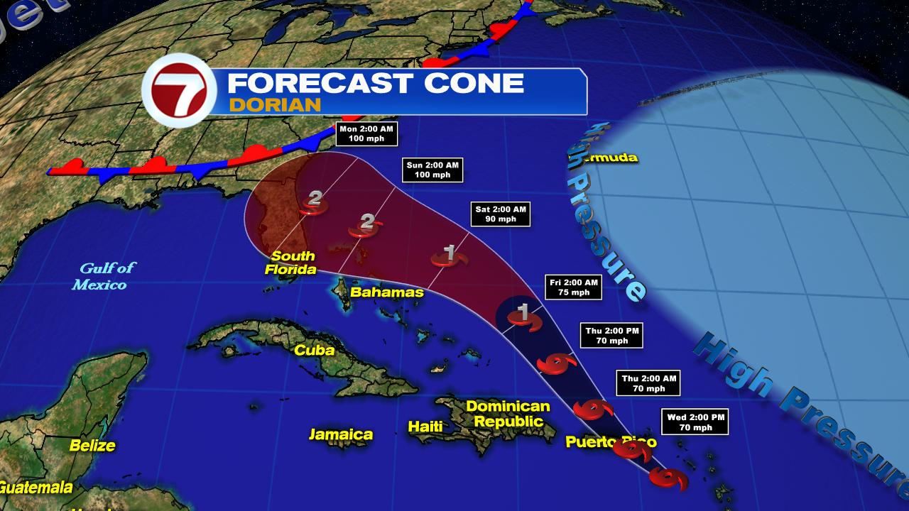
UPDATE The cone has shifted west and now begins at the Palm Beach co line to points north along Florida's East Coast.  A Tropical Storm Watch has been issued for Broward County.  The National Hurricane Center still expects Dorian to take a turn northward.  Extremely Dangerous Dorian to hit Abaco Island & Great Bahama later today.   A Tropical Storm Warning now in effect from Palm Beach/Broward County line north to Sebastian.


What does this all mean?
The National Hurricane Center (NHC) expects the eye of Dorian to remain east of the the Keys, Miami Dade, & Broward counties. The eye or center of the storm is where you find those extremely violent and destructive winds. But, we can still get see some of its impacts.

At this moment from NHC:


  • Dorian very healthy with well defined eye
  • Still in low shear environment, which means no strong winds in the upper levels to weaken it
  • It will move over warm but shallow waters. The shallow waters should exhaust its heat supply not allowing Dorian to strengthen further. (keep fingers crossed) It may weaken a bit in 12 hours
  • High pressure to the East to remain in place through today pushing Dorian due west. It should stop tonight letting Dorian to slow down to a crawl
  • The Euro model is the most aggressive pushing Dorian further west
  • The turn NW is now expected in 2 - 4 days


Before it nears the Florida coast, it will plow though the NW Bahamas.

  Impacts:


The eye of of Dorian is expected to impact Great Abaco on Sunday. The red shaded area is where those hurricane force winds will strike. Its an area about 30 miles wide. Tropical storm force winds in orange will impact an area 115 miles wide.


By Monday the eye moves over Grand Bahamas. Once again the red shaded area is where the strongest winds will be.

Watches & Warnings


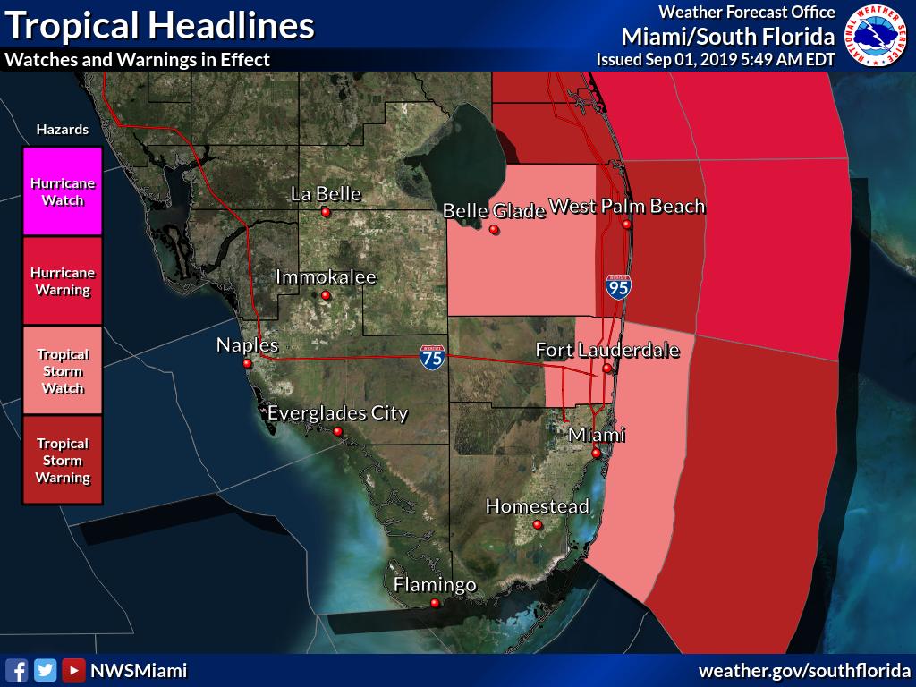
  1. Tropical Storm Watch for Metro Broward county and coastal waters. This means winds between 39 & 73 mph may arrive in 48 hrs. Tropical storm warning for offshore waters. This means winds between 39 & 73 mph may arrive in 36 hrs
  2. Tropical Storm Watch for Coastal waters of Miami Dade. This means winds between 39 & 73 mph may arrive in 48 hrs. Tropical storm warning for offshore waters. This means winds between 39 & 73 mph may arrive in 36 hrs


Impacts

NW Bahamas:  Hurricane force winds later today with heavy rainfall. 12 - 24 inches possible with some getting as much as 30 inches.  A dangerous and destructive storm surge of 15 - 20 feet high. Life threatening Flash Floods expected in Abaco Islands  & Grand Bahama through Monday.

Central Bahamas: Winds with rainfall amounts  2 - 4 inches with some areas as much as 6. Some gusty winds for you.

SE Bahamas & Turks & Caicos: You should not see any major impacts but some spotty rain with breezy conditions are possible.

South Florida: If the cone were to remain as is, here are the possible impacts. The Keys may see some moments of windy conditions of less then 39 mph.  Broward and Miami-Dade could get on & off gusty winds of 39 to 73 mph. Highest probability now is for Broward.


The Keys: Some storms are possible. The rain could lead to street flooding. Winds up to 40 mph at times. Higher surf.


Miami-Dade: Winds over 40 mph at times. Possible heavy rain as much as 2 - 4 inches with isolated spots getting 6". This could lead to flooding, specially with the ground saturated from recent rainfall.  Storm surge not expected. We may still see some tropical storm watches and warnings issued. Usually when this happens, you are urged to protect your property with shutters. You know your property best, what it can and cannot withstand.

Broward: Tropical Storm Watch issued for you. You are out of the cone but you can expect some tropical storm force winds. Tropical storm force winds of over 40 mph can be expected in 2 days. This is why NHC has issued a storm watch. Potential for heavy rain is there as well as flooding.  Usually when this happens, you are urged to protect your property with shutters.  You know your property best, what it can and cannot withstand. 

Bottom line: Hopefully Dorian will continue to move away from FL as it nears. While no direct impact is still expected, hurricanes can cause plenty of trouble far away from their center. Feeder bands can still move over much of South Florida with the potential some winds and rain.


Please monitor the hurricane for any additional changes both good or bad.

Thursday, August 29, 2019

Dorian: What you need to know

UPDATED IMPACTS SECTIO LOWER IN THE PAGE.  Some of the graphics may be slow to upload due to increased demand. 

We are all apprehensive about hurricane Dorian in the Atlantic waters aiming for the State, possibly land falling as a major storm. I will try to provide you with as much info as I can to help you prepare just in case it ends up somewhere in our neighborhood.

Where is Dorian now


I will focus on WSVN's viewing area, that being Broward, Miami Date Counties, and the Florida Keys. We also have very loyal viewers in the Bahamas.

  • It's presently a Category 2 system. Winds over 100 mph
  • Roughly under 800 miles away from the NW Bahamas and South Florida.
  • It remains compact with a small wind field. Hurricane winds over 75 mph, extend outward 25 miles.
Where is it headed?


The cone by next Monday has the eye of the storm, or the center, anywhere between Georgia Coast  and a few miles north of Key West. The forward speed has slowed down. DO NOT FOCUS on the little hurricane icon, that just shows the category the system may be on that particular day. Dorian promises to be a Category 3 - 4 offshore Florida on Sunday night. Those are winds in excess of 130 mph.

What's pushing it here?  Believe it or not, as strong and powerful as hurricanes are, they do not move on their own. They need a larger system to do that and in this case it's the Bermuda High. The high will continue moving to the East Coast of the US. The issue encountered by most models, is trying to figure out how fast the high will move and will it head north or stay on a firm westerly track.

To make things even more complicated, it appears the high may stop pushing Dorian West on Monday. This will make the hurricane slow down and possibly linger somewhere over the coast. It could make a turn north or northward, lets keep our fingers crossed. If it makes the turn early , South Florida may be OK, if it doesn't it could be a terrible scenario with a major system traveling north along I-95 from South to North Florida.

Models


I've heard about the European model and the American (GFS) model. Which is best?  Yes, these are the two most popular but if one was best, then we'd only need one.

There are dozens and dozens of models used to determine where the eye of a storm will end up. Each is tasked to look at different items in the atmosphere. Each provides their own track which can have a hundred mile error on either side.  The experts at the National Hurricane Center take all these models into account and average them out to give us the cone of concern.

The models will continue to shift over the next 24 to 48 hours, forcing the cone to move up and down on the state. Need to keep monitoring.

By the way, models are like athletes, outperforming one year and stinking up the joint the next.

Where is it going to hit and when? Seeing how large the cone is and how strong the hurricane may be as it nears Florida here is a break down. Lets plan for worst case scenario.

Turks and Caicos, SE & Central Bahamas: You may see the risk of storm surge by Friday, specially in the Central Bahamas. Rain amounts 1 - 2" with some spots up to 4". Keep an eye out just in case Dorian tries to surprise you. The center should remain to your north.

NW Bahamas:  A hurricane watch is now in effect for you. This means hurricane force winds can arrive in 48 hours. Get your last minute preps done. By Sunday, the winds will start to pick with some pockets of heavy rain. Between 6 - 12 inches with areas as much as 18.  Both will increase in frequency and strength. It may stay very stormy through late Monday. The rain may cause Flash Flooding. Strong dangerous  surge of 10 -15 feet above normal possible along with large destructive waves.

Broward and Miami Dade: By Monday evening the heavy rain should start to move in and winds will pick up. The seas will be choppy.  Some rain forecast models are calling for 6 - 12 inches with some spotty areas getting almost 12. This will surely lead to stranding water. If you live in an area prone to flooding you may need to seek safe shelter with friends or family in another location. Life threatening storm surge is also a possibility. Evacuations may be ordered.

The Keys: As of Thursday night, you are in the cone from slightly north of Key West. You too could see hurricane force winds, heavy rain, and storm surge. Make sure you are ready to evacuate if ordered to do so. Even if you are out the cone, storms can impact areas hundreds of miles away from the center. Please prepare accordingly.


When will they issue watches and warnings for us? 


Generally watches are issued 48 hours in advance of a system arriving with a warning issued when a system is 36 hours out.  NHC will issue these accordingly. This will be your cue to finish your last minute preps. Also, if indeed we are looking at a major hurricane impacting us, evacuation orders may be issued. Be ready to go if ordered.

Should I be getting ready now? Yes. Review your supplies and get what you need. I usually suggest you put up your shutters once watches or warnings are issued, but you know best. If it takes you a long time, you may want to start early to give you additional time for preparations.

I sincerely hope this system somehow weakens or shifts direction before reaching Florida and all this was just an exercise in readiness. But if it isn't, it pays to be ready.

We'll be watching


Wednesday, August 28, 2019

Dorian may be a Cat 2 next to Florida

The National Hurricane Center thinks Tropical Storm Dorian may be as strong as a Category 2 as it nears the east coast of Florida by the weekend.


As of mid morning Wednesday, Dorian has 60 mph winds and appears to be on a course to move across the East Coast of Puerto Rico. Heavy rain and gusty winds are expected there. On this track, Puerto Rico's land mass may not interfere too much with its structure. This may allow Dorian an easier passage back into the warmer Atlantic waters.

Forecast Track


Once in Atlantic:

  • The center of Dorian should miss the Turks & Caicos and most of the Bahamas. Remember the storm can impact many areas far away from the cone. Also, the forecast can change as atmospheric conditions change. Keep an eye out.
  • Warm waters of the Gulf Stream can provide Dorian fuel to intensify. As of this update it may be a cat 2 with winds between 96 & 110 mph and stronger gusts.
  • Dorian could be anywhere in the area highlighted red over the weekend. DO NOT FOCUS on the little numbers/icons. The center of Dorian could be between Miami Dade County and the Georgia coast. 
  • Where it will finally end up depends on how much the high, or blue area on the right of the map, pushes Dorian west.  Forecasts change as the atmosphere changes. Please monitor until the models give us a better idea.
  • Final thought: Even far away from the eye of the storm, severe weather can take place. From strong storms to gusty winds to isolated tornadoes. A hurricane's influence goes far beyond the eye wall.
We'll be watching


Dorian Forecast as Cat 1 near Florida

Tropical Storm Dorian may be a category 1 system with winds over 73 mph as it nears Florida by the weekend.


Dorian is trying to get its act together. As of early this morning, the system looked somewhat disheveled with most of the storms (highlighted in the yellow, oranges, & reds), sitting to the north of the center of circulation, yet as of 2 am the winds managed to kick up to 60 mph. They were at 50 mph for much of the day on Tuesday. The southern half of the system remained mostly dry.

There is also plenty of dry air around the storm starving it for moisture, as well as some light shear (strong upper winds that can cut down developing thunderstorms within Dorian) still ahead of it.

Where is it Going?


  • This is the official forecast cone from the National Hurricane Center (NHC). It suggests that by late afternoon/early evening it could make landfall across SE Puerto Rico with winds around 60 mph. It is capable of dropping up 4-6 inches of rain with some areas getting as much as 8. This will surely lead to flooding.


  • The big question is what will happen after wards. Depending on how long it travels over land, it may emerge a tad weaker into the Atlantic Ocean. But with less shear there and moving over some very warm waters, it has the chance to grow into a category 1 hurricane with winds over 73 mph by Friday.


  • The center may avoid the Turks & Caicos, as well as the SE & Central Bahamas. You may still get some thunderstorms and gusty winds but no direct hit (as of 11 pm Tuesday night). The cone and intensity may change again today.  


  • By Friday it is forecast to become a hurricane and start moving west as high pressure moves in form the East.  DO NOT FOCUS on the little "H" by Daytona beach, the center of Dorian can be anywhere in the area highlighted, from Miami-Dade north to SE Georgia over the weekend.  We should have a better idea of the final track and intensity by Thursday.


Models


There are dozens of models that are in fair agreement the system will aim for Florida.  Each model may look at different criteria. The bottom line is that each one of the lines can have a hundred mile margin of error on each side. That is why it's important to look at the cone where all the models are averaged out. There is no such thing as a perfect model. If you are in the cone, you need to prepare. And even if you are outside of it you may still get some squally weather.

While Dorian may be a Cat 1 as it approaches Florida, intensity forecasting is extremely difficult. Many factors like water temp, land interaction, and blowing winds in the upper levels of the atmosphere, can influence how weak/strong it may be. The atmosphere is in constant flux and so the strength of Dorian may change before its arrival. Everyone across the Bahamas & Florida should monitor.

Watches & warnings may be issued for parts of South Florida later this week. Review your supplies now and be ready in case Dorian decides to pay us visit.


We'll be watching


Tuesday, August 27, 2019

Dorian, a So FL Concern

Tropical Storm Dorian is now in the Eastern Caribbean Sea. It may not be until Friday that it reenters the Atlantic waters. What happens then is still uncertain.


The Satellite view shows a small, compact system that has just crossed over the Windward Islands into the The Caribbean Sea.

Here are the main points
  • Dorian remains small & compact and its inner workings are not well organized. It remains as a tropical storm through its forecast.  ((Remember intensity forecasting is very difficult. This may change as atmospheric conditions around the storm change)).
  • The Storm will dump rain over the Central Lesser Antilles. Some areas could get up to 10 inches of rain. This will lead to flooding.
  • Hurricane watches are now up for Puerto Rico and for the Eastern part of the Dominican Republic. Haiti , you need to monitor
  • The National Hurricane Center said as of 8 am this morning, "wind and rain impacts are possible for the Bahamas & Florida later this week (for Bahamas) and the weekend (for Florida)."
Dorian's Health

It has been battling dry air around it. This has taken a lot of moisture away from Dorian keeping it from getting stronger even though it has been moving over warm waters. The wind shear (strong upper level winds that can cut a storm down) has also been light, giving Dorian a chance to grow stronger but it has yet to do so. 

Where is it going and how strong will it be?

Dorian is being pushed by high pressure sitting across the middle of the Atlantic Ocean. Believe it or not, as strong and powerful as hurricanes can be they do not move on their own, they need something else to shove it along... in this case it's the Bermuda high.  This is a huge dome of air (heavier air than average) wind clockwise spinning winds. This is making Dorian move towards Puerto Rico & Dominican Republic.

11 am Cone of Concern


It appears Dorian may actually go in between Puerto Rico and Dominican Republic. Will the high terrain of Hispaniola help to weaken it further remains to be seen. (Dom. Republic has the largest peak in all Caribbean , Pico Duarte, at over 10 thousand feet tall. This can help disrupt Dorian's structure). As of the 11 am advisory, NHC keeps Dorian as a tropical storm as it passes this area. This may be good news as far as weakening Dorian, but it may be bad news for our neighbors in Dom. Republic. Dorian may slow down and dump plenty of rain that could lead to flooding, land & mud slides. Shear should pick up as well by then also helping to keep it weak.

The Bahamas and Florida

Even though the cone suggests the system can be anywhere in Florida by Sunday morning, where exactly it will make landfall and how strong it will be are still unknowns. Its future path and strength will depend on how much / little interaction it has with Dominican Republic & Puerto Rico. As of this moment they can expect between 4 - 6 inches of rain with higher totals in some areas.

  • Once near the Southeastern Bahamas things begin to change.
  • Shear weakens
  • It moves over some of the warmest waters in the Atlantic Basin with temps hovering between 85 and 90 degrees. Higher in some spots
  • It may allow for the system to breath a bit better letting it get stronger. How much is uncertain.

Bottom Line

Bahamas and South Florida should monitor
Check your supplies and be ready if and when watches and warnings are issued for us

We'll be watching


Sunday, August 25, 2019

Tropical Storm Dorian Aims for the Lesser Antilles

The National Hurricane Center (NHC), is monitoring tropical storm Dorian roughly 500 miles east of Barbados and an area of low pressure a few hundred miles east of Jacksonville. 


The satellite loop is centered over Haiti/Dom. Republic and Puerto Rico. You can see Florida and the Bahamas upper left. Cuba, The Cayman Islands, and Jamaica left Center. The Lesser Antilles to the right, and South America at bottom.

Tropical Storm Dorian is the swirl moving into the picture from the right. The Low next to Florida is the spin to the east of Jacksonville.

Morning Update

  • As of Sunday morning, Dorian maintains its westerly direction
  • Thunderstorm activity is the same as on Saturday
  • So far no further strengthening
  • Winds over 39 mph stretch out from the center about 25 miles.
  • It's forward speed is between 10 - 15 mph
  • At this rate it should be near the Central Lesser Antilles early next week.
  • A recon mission is scheduled for later today
Places with storm warnings
  • Tropical Storm Warning for Barbados 
  • Tropical Storm Watch for St. Lucia, St. Vincent & the Grenadines


Where is it headed?


This is the official forecast cone from NHC. There is a small change, as it now has a more westerly track than a mere 24 hours ago through the short term into the Windward Islands. It also keeps the system as a storm through the Lesser Antilles.

Models

Models are very much clustered along the same route as the NHC cone. However they note that the forecast track may change later today to an even more northwesterly shift in the forecast.

The impacts across the Lesser Antilles are expected to be:

Rain: It has the potential to drop 2 - 4 inches with some spotty areas seeing as much as 6 inches
Some low areas may get standing water
By early next week, large swell should be arriving causing life threatening surf & rip currents

How strong may it get?
Intensity forecasting is not as accurate a science as the forecast track.
We look for two things; how warm / cold the water may be, and are there any other systems surrounding Dorian that could impact its health.

Water temps: 
Anything above 80F of ocean temperature is like jet fuel for tropical systems to grow. On the scale above, 28.1 Celsius is the equivalent of over 82 degrees. Plenty of energy surrounds Dorian, which will allow it a chance to gain strength. The waters are even warmer as it approaches Cuba and the Bahamas.

Shear


This is the term used to describe strong winds in the upper levels of the atmosphere. They can help cut down the developing cloud tops of thunderstorms inside Dorian.

On the image above, find the tropical storm icon, and that is the location of Dorian. Notice the yellow green area just to its left. That is shear. It's on the weak side at the moment, but strong enough to nag the system and hopefully keep it from reaching hurricane status as it moves over the islands. It will have a window to grow into a hurricane once in the Eastern Caribbean.

Shear Forecast


By Wed/Thu , Dorian should be somewhere in the circle over Dominican Republic. The shear there is forecast to get stronger due to an area of low pressure also in the upper levels of the atmosphere. This should weaken the system. Also, if it does unfortunately impact Puerto Rico, the Dominican Republic or Haiti, it could lose strength even further. Any brush with larger land masses will interrupt its life cycle, specially over Dominican Republic which has the largest mountain peak in all of the Caribbean, Pico Duarte. This could act as a huge wall weakening Dorian further. The down side to this, will be the possibility of heavy rain across Haiti and Dom. Republic which will lead to flooding, land and mudslides. This weakening is reflected in the latest cone showing Dorian down to Depression level as it leaves Haiti/Dom. Republic.

Need to monitor

Since the strength and future track past Hispaniola is still uncertain, all areas from Jamaica, Cuba, the Bahamas and South Florida, should monitor the progress of the system. While the worry factor is not low, we should keep an eye on it.This is the perfect time to review your plans and supplies just in case Dorian decides to schedule an unwanted visit.

Western Atlantic Low


The low pressure system that dumped rain across South Florida on Saturday has now quickly moved into the western Atlantic east of Jacksonville. It has an 80% chance of becoming a storm over the next 5 days in the area highlighted in red. It appears it will be a worry for the shipping lanes only.

We'll be watching


Saturday, August 24, 2019

Active Tropics

The weekend starts with a trio of tropical activity. One area dumping rain across Florida, a new storm develops in the Atlantic, and a disturbance spins up in the Gulf of Mexico.

New at this hour:
  • Brand new storm by the name of Dorian to the North of French Guiana in South America.
  • Low pressure near the Lake Okeechobee area
  • A disturbance just south of Texas 
New Tropical Storm Dorian


Early Saturday, NHC determined that a low pressure system roughly 1000 miles east of the Lesser Antilles, had developed more thunderstorm activity and was classified as Tropical Depression #5. It developed a closed center of circulation with winds to 35 mph. At 5 pm, the winds passed 39 mph and was classified as a Tropical Storm.

Where is it going?


High pressure will push it NW and aim for the Lesser Antilles and eventually stay on a course that could include Puerto Rico, Dominican Republic, and Haiti.

For the moment, strong upper winds are keeping the storm in check but over the next few days, that shear will weaken allowing it a chance to grow stronger. Everyone along this path should get ready for a possible strong event as it is forecast to be a hurricane while it nears the islands early next week.  Cuba, Jamaica, the Bahamas, and South Florida should monitor closely.

Low over Florida. Sat loops courtesy TropicalTidbits


The area of clouds is sitting mostly to the east of Florida with the center of the spin around Lake Okeechobee. This low pressure system is causing widespread downpours mainly over South Florida. Because the center is sitting over land today, we don't expect it to develop any further in the short term. Once it moves over the Western Atlantic, it could become a depression or a storm as it moves away from us.  NHC is still giving it a 90% chance that it could develop over the next 5 days. Even if it doesn't, it could provide some heavy rainfall from the NE Bahamas, west into Florida.

Yesterday a recon mission was planned to investigate this system, that mission has been cancelled, with a new one set for Sunday.

Model Data (Courtesy TropicalTidbits)
This is Invest 98L. Most models agree the low will remain over Florida a day or two, then finally getting pushed out into the Atlantic possibly late Sunday.

Another disturbance is being watched

NHC says a low pressure system has formed along the Texas and Louisiana coastline. It is trying to get its act together and has a 10% chance of turning into a depression or a storm over 48 hours.
Even if it doesn't develop, (it may be too close to land for that to happen) it could still drop plenty of rain leading to street flooding.

Models
This is now Invest90L. These are extremely early model runs. They suggest the low will meander across the Gulf States possibly looping back into Northern Florida. A reminder these early models are just providing a guesstimate. Keep monitoring.

We'll be watching


Thursday, August 22, 2019

Drenching Rains Possible

An area of clouds and rain sitting over the Bahamas is being watched by the National Hurricane Center (NHC). It could provide South Florida with a drenching thru the weekend. As of Thursday night, it has become an area of low pressure between South Florida and Andros Island in NW Bahamas.


Satellite view shows the area highlighted.  This low pressure continues to get its act together as it moves NW towards Florida. NHC has deemed it Invest 98L.
Chances for development


NHC says the low has a 50% chance of turning into a depression/storm in the area highlighted in orange over a period of 5 days. Even if it doesn't develop, it could still drop plenty of rain, not just in South Florida, but across the Bahamas as well.

Bahamas Rain


The low has been soaking the Central Bahamas with on and off downpours since Wednesday afternoon. This soggy pattern is expected to stay for a few days.

 The Forecast


While the disturbance, now a low, will move to the NW, plenty of moisture is expected to splinter away and move over South Florida.

Rain Totals


Models show large totals of rain across the Bahamas, and anywhere between .87" to 1.41" over So FL thru 5 days. That may not be too impressive but with the ground saturated with recent rainfall, any additional downpours will lead to street flooding.

Potential for drenching rainfall


The National Weather Service says South Florida has a marginal chance to see very heavy rain on Friday. This just means the conditions are ripe for big downpours to sit over an area and flood local streets. It may not happen, but be on the lookout.

If it develops, where is it going?


Keep in mind that at this early stage, models are giving us a guesstimate. There is no good starting point for them to use, therefore, they can't provide an ending point. As of this early run, the few actually providing data, move the system over Florida. This is a good reminder that the peak of hurricane season is just a few weeks away.

I'll keep you posted


Thursday, August 1, 2019

One wave done, still watching another

A wave close to Florida over the last few days moved into the area on Thursday bringing with it pockets of heavy rainfall. The remnants of this wave have the potential to bring us on and off downpours through the weekend.

 Thursday's rainfall totals


The wave brought us heavy rain in some areas and barely touched others. This is very typical of disorganized systems. We could see more in the next few days.

Soggy Set-Up
 

You can see all the clouds lingering across the State, that is your wave. It wasn't supposed to move in until the weekend, but it sped up and brought us the rain.  There is also a low pressure spin in the Gulf, but its in the upper levels of the atmosphere. In the Atlantic we are watching high pressure staying put. A lot of features that can make for wet days.


The models suggest the high and low will drag in plenty of tropical moisture from the Caribbean. It will get funneled here and as long as the high and the low don't move, the rain should keep coming.

Forecast Rain Totals


Our in-house model suggests anywhere between 1.53" over Havana to almost 3 inches in Ft. Lauderdale. NWS says spotty areas may see up to 5" or more through Tuesday. This will lead to street flooding in low lying areas.

Still watching a wave in the Atlantic


Meanwhile in the middle of the Atlantic a second wave, now a broad area of low pressure, is moving towards the Lesser Antilles. NHC is giving it a 70% chance it could become a depression or a storm over the next 5 days in the area highlighted in red.

Models:


High pressure will push the low towards the islands.The low will try to avoid the Saharan Dust, which usually starves systems for moisture. There's a plume ahead of it and one behind it. If it can overcome this, it may organize a few hundred miles before the islands.
 

Once it nears the islands it will quickly run into some strong upper winds (shear), they can cut down the developing cloud tops in a storm system. This may weaken whatever develops, or defeat it altogether.  All we can do is wait and see what actually develops.