Thursday, August 28, 2014

The Tropical "Not So Fab" Four

August is the second most active hurricane month, with the peak of the season coming September 10th. At the moment NHC is still monitoring 4 areas, none of which appear to be a threat to anyone.

The latest on Hurricane Cristobal, is that its threading the needle between Bermuda and the east coast of the US.

It should only be a concern for the shipping lanes. It will however cause some strong surf and rip currents across New England and the Middle Atlantic States.


The other three areas NHC is considering are a bit less glamorous.


  • The X near Mexico is an area of disturbed weather slowly moving west. It has a minimal chance for growth. Even if it does not develop it should provide some drought relief for Northern Mexico and Southern Texas.


  • The second X in the eastern Caribbean is a Tropical Wave moving west with little promise. NHC is giving it a small chance for growth once it reaches the Yucatan Peninsula.


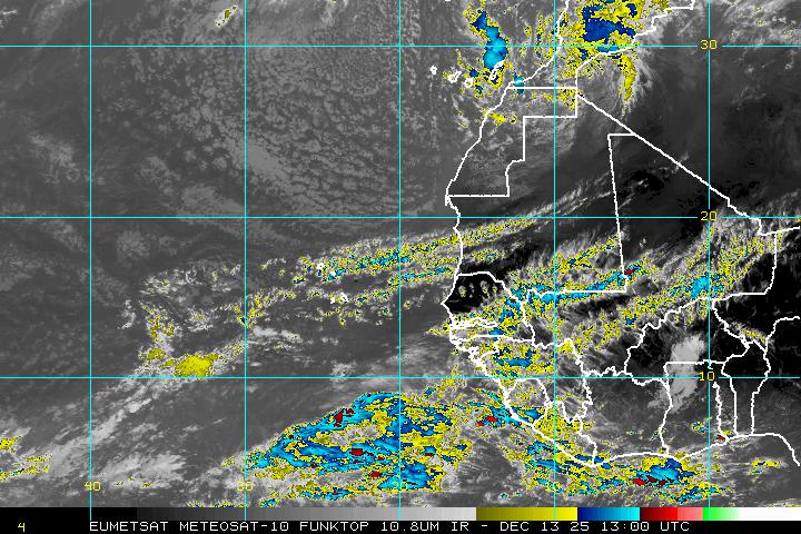
  • The most interesting feature is the third X over Western Africa, also an area of clouds and rain. This feature has been over land for days and remains in the cross hairs of NHC. They are giving it a moderate chance for development once it reaches the Eastern Atlantic. The area highlighted in orange is where it could become a depression or a tropical storm.


The reason why I'm watching this one more carefully is because we are in the middle of Cape Verde Season.


What is Cape Verde Season?
It is a season within the Hurricane season usually lasting from August to late September.

This is according to NASA:
Systems tend to form in the vicinity of those islands and have a reputation of making landfall in the U.S. They usually develop from tropical waves that form in the African savanna during the wet season

The average Atlantic Hurricane season brings with it approximately two Cape Verde hurricanes. These hurricanes are usually the most intense and the biggest storms of the season because they develop so far to the east and can travel over a large area of warm, open ocean waters that help power them. There are also no land forms in the way to slow tropical cyclones if they form near the Cape Verde Islands. 

Cape Verde tropical cyclones also tend to be the longest-lived storms, because of the huge area of open ocean they have to move through. Some have even moved into the Caribbean and Gulf of Mexico.

Hopefully we will stay quiet.

Wednesday, August 27, 2014

Four areas of concern. Are we ok?

A look at the enhanced colorized satellite imagery shows a great deal of cloud cover and storm activity. It is after all near the peak of hurricane season, that being September 10th.  The first thing you will notice is a big spin east of Georgia, that is hurricane "Cristobal".  It should remain as an open water system moving north. It will only be a worry for the shipping lanes.


Other Features:

  • There is also a small dot near Texas in the Gulf of Mexico, this is a weak area of low pressure that could grow quickly. A recon mission is on stand by to check it out. 
  • In the middle of the Atlantic there is another area of clouds and rain, a wave that has a small chance for development.
  • The fourth area is still over Africa.
  • All the other clouds and rain areas over the Caribbean and Central America are due to weak waves.

We know what to expect from "Cristobal", lets see what NHC is saying about the other three areas.

Low in Gulf:
Shower and thunderstorm activity associated with a weak low has increased today.

Additional development is possible before it moves inland over southern Texas and northern Mexico on Thursday.
* Formation chance through 48 hours...low...20 percent.
* Formation chance through 5 days...low...20 percent.


Here are the latest model runs on this feature.


Wave about 600 miles east of the Lesser Antilles:
Disorganized cloudiness and showers at this hour. It will move west without incident until it nears the Yucatan Peninsula where environmental conditions could become favorable for some development.
* Formation chance through 48 hours...low...near 0 percent.
* Formation chance through 5 days...low...10 percent.

Wave over the West Coast of Africa:
This is the most interesting feature. NHC believes that by the time it moves offshore into the Eastern Atlantic Ocean, conditions appear to be favorable for some development.  This is after all Cape Verde Season where most of the tropical activity forms out here. We'll be watching.
* Formation chance through 48 hours...low...near 0 percent.
* Formation chance through 5 days...medium...40 percent.

Are we ok?
As of this moment, and through the holiday weekend, we remain free of any tropical threat. But Mother Nature always has the last word so check back from time to time in case we get a curve ball thrown at us.

Tuesday, August 26, 2014

Tropical Trouble

September is the most active month for tropical activity,  peaking on September 10th, but August comes in right behind in second place.

As of Tuesday morning NHC is monitoring four areas in the Atlantic basin. We begin with "Cristobal". As of early morning it was a minimal hurricane with 75 mph winds heading NE.

This is not a good looking system. It lacks the typical symmetrical look of a healthy storm.

The western side is still rain and cloud free while most of the rain and gusty winds remain to the east.

Recon planes still show hurricane force winds and most models are forecasting some strengthening.

There is plenty of rain associated with north/south slant of "Cristobal". Some of that rain is still impacting the Southeastern Bahamas, Hispaniola, and Eastern Cuba.

It should by pass Bermuda and remain as a worry only for the shipping lanes.


"Cristobal" will generate some high swells across the Atlantic waters making it rough for mariners.

These waves will also bring along the threat of rip currents up and down the US Coast.

Boaters and swimmers are asked to take extra care when venturing into the Atlantic waters over the next 48 hours, until the threat subsides.

By the weekend it should arrive in the cold waters of the Northern Atlantic otherwise known as the hurricane graveyard.


Aside from "Cristobal", there are three other features worth mentioning. We'll begin with the area in the Gulf of Mexico.

1) This is an area of clouds and rain, not too significant, but it is sitting over very warm waters that could allow it to grow. For the moment atmospheric conditions are not favorable for development so NHC is giving it only a 10% chance for growth over 5 days.


2) The x in the middle of the Atlantic is about 900 miles east of the Lesser Antilles. It has some showers and thunderstorms. It had a better chance for growth on Monday, but as of today, environmental conditions are not expected to be favorable for significant development. That could change in a few days. NHC is giving it 20% chance for development through 5 days. If it does organize it may do so over the area marked in yellow.


3)  The third area monitored hasn't even emerged from the West Coast of Africa, but NHC thinks it has the potential for organization. They say a tropical wave is forecast to move off the west coast of Africa
late this week, and conditions appear to be favorable for some development thereafter. NHC is giving it a 30% chance for growth. If it develops, it could do so over the area highlighted in orange.


Stay tuned.

Monday, August 25, 2014

Kris-to-bal , Kris-TOE-bal What gives?

I have received hundreds of e-mails and countless texts complaining about our pronunciation of Tropical Storm Cristobal. They suggest, claim, accuse me of giving it a Latin spin. Let me explain how it works:

The World Meteorological Organization is in charge of coming up with the names for storms. A special  Hurricane Committee determines a pre-designated list of hurricane names six years in advance. The names are suggested by Meteorological and Hydrological Services from North/Central America and the Caribbean.

As you can imagine, the names suggested cover the languages spoken throughout the entire Atlantic basin, English, Spanish, French, and Dutch.  This is why you may get a name like "Andrew"- English, Georges-French, Cristobal-Spanish , Van -  Dutch.

These names are NOT chosen after any particular person. 

When I worked at Telemundo years ago, we did not pronounce "Andrew" as "Andres"... we used the correct English terminology, and thus we do the same today with Cristobal.

Here is the link for all the names and their pronunciations for the next 6 years.
Hurricane names

Sunday, August 24, 2014

Tropical Storm Cristobal

Where is it?
Tropical Storm Cristobal is spinning very close to Mayaguana Island in the Bahamas, or roughly 500 miles southeast of South Florida. It will start moving NW over the next 24 hours at a very slow pace.
Tropical storm force winds extend outward from the center about 140 miles with most of that being felt to the northeast of the system and mainly over open waters.

At the moment:
"Cristobal" organized some overnight with more rain developing within its feeder bands, but the winds have not picked up any. As of this writing they remain around 45 mph.

Looking at the color enhanced satellite imagery , with the golds and reds showing the heaviest of the rain, the strongest downpours are impacting the Turks and Caicos islands.

Most of the heavy rain is over open waters. Clear skies dominate the Central and Northwestern Bahamas, but by Monday this area will start feeling the effects of "Cristobal"

The following statement is from NHC: 

RAINFALL...CRISTOBAL IS EXPECTED TO PRODUCE RAINFALL TOTALS OF 4 TO 8 INCHES OVER THE SOUTHEASTERN BAHAMAS...THE TURKS AND
CAICOS ISLANDS...AND THE CENTRAL BAHAMAS THROUGH TUESDAY.

ISOLATED AMOUNTS AROUND 12 INCHES POSSIBLE. STORM TOTAL RAINFALL AMOUNTS OF UP TO 12 INCHES ARE POSSIBLE IN PORTIONS OF HISPANIOLA...WHERE THESE RAINS COULD PRODUCE LIFE-THREATENING FLASH FLOODS AND MUDSLIDES...ESPECIALLY IN AREAS OF MOUNTAINOUS TERRAIN.

What is next?
Most models show "Cristobal" slowing down and dumping plenty of rain across the Bahamas. It should wobble a bit more to the northwest through Monday before running into some very strong upper level winds.

These strong winds will be coming off the Eastern Seaboard on Tuesday helping to push  "Cristobal" away from most land areas.  By Thursday however, those winds weaken just enough for "Cristobal: to swing closer to the US, but still remaining offshore.

If it should reach hurricane strength , it may do so east of the Carolinas. It should steer clear of Florida altogether.

This is the latest from NHC regarding the cone:
The track has been shifted eastward, but it remains along the western side of the
guidance envelope out of respect for the ECMWF and continuity of the previous forecasts.The new track forecast is closest to the HWRF, but is well west of the latest multi-model consensus.  

Future eastward adjustments may be required if the eastward model trend continues.  Given that a large spread remains in the guidance, the confidence in the track forecast remains lower than normal.

The means, the cone could shift a bit more west or east over the next 24 hours, but in general, the system should remain a few hundred miles away from us.

South Florida Impacts?:
Most of what we will see from "Cristobal" depends on how strong it gets as it slides away to our east. We are looking at mostly rough marine conditions with large swells developing by Monday and Tuesday. Tuesday maybe the closest approach to our area with the possibility of a few stray storms across South Florida.  More storms may linger until Friday.

Boaters and surfers:
Should really pay attention to "Cristobal" . If you plan on boating beyond Biscayne Bay and over offshore coastal waters, navigation could be a little rough. There is a chance for strong winds and higher seas the further east you travel.

Bottom line:
The Southeastern and Central Bahamas should see squally weather over the next 24-48 hours. South Florida may get a downpour or two over the next few days with no direct impact. Then the Mid Atlantic states could see rough surf and a few t-storms depending on how close "Cristobal" gets.
And remember as much as we value models and forecast outputs, Mother Nature always has the last word. Check in from time to time for updates.

Saturday, August 23, 2014

New Tropical Depression

NHC has upgraded the area of clouds and rain near the Southeastern Bahamas to a depression, the fourth of the season. For the moment the Southeastern and Central Bahamas as well as the Turks and Caicos islands could see between 4-8 inches of rain.
 
LOCATION...21.8N 72.3W
ABOUT 75 MI...120 KM NE OF GREAT INAGUA ISLAND
ABOUT 255 MI...410 KM ESE OF THE CENTRAL BAHAMAS
MAXIMUM SUSTAINED WINDS...35 MPH...55 KM/H
PRESENT MOVEMENT...NW OR 310 DEGREES AT 12 MPH...19 KM/H
MINIMUM CENTRAL PRESSURE...1005 MB...29.68 INCHES

Even though the system doesn't look that organized on satellite imagery, the afternoon recon mission finally found the illusive center they've been looking for the last 2 days.

Here area the advisories issued:

THE GOVERNMENT OF THE BAHAMAS HAS ISSUED A TROPICAL STORM WARNING
FOR THE SOUTHEASTERN BAHAMAS...INCLUDING THE ACKLINS...CROOKED
ISLAND...LONG CAY...THE INAGUAS...MAYAGUANA...AND THE RAGGED
ISLANDS...AS WELL AS FOR THE TURKS AND CAICOS ISLANDS...AND FOR THE
CENTRAL BAHAMAS...INCLUDING CAT ISLAND...THE EXUMAS...LONG
ISLAND...RUM CAY...AND SAN SALVADOR.

The official forecast cone is a blend of many models.
Some of the models keep this system from intensifying over the next 48 hours, but after that there is a chance for further growth.

Most show the Bermuda high moving east and allowing TD 4 to slowly curve out to sea.    However, according to NHA, "there is significant disagreement in
the timing and sharpness of the turn in this and previous dynamical
model cycles.

Currently the GFDL and GFS are along the western
edge of the guidance envelope showing a more westward track and
a slower motion at day 5. The ECMWF, GEFS mean, and HWRF show a
sharper turn and a more northeastward motion by day 5 on the east
side of the guidance envelope. "

They also say , "Given the spread in the guidance and the recent
formation of the system, confidence in the details of the track
forecast is lower than normal."  Which means the cone can drift further east or west over the next couple of days.  Lets keep watching this one just in case.


Next Depression?

Brief Update:

As of early Saturday morning the area of disturbed weather near Dominican Republic looks a little better organized. Heavy downpours are impacting Haiti, Dominican Republic, and Puerto Rico. These areas remain under flood advisories.

A Recon plane is investigating the disturbance in search of the illusive center of circulation.

Without a good fix or starting point, the models have a tough time generating a possible track.

Regardless of intensification heavy rain and strong gusty winds can be expected over that area through Sunday.

The high terrain of Dominican Republic is playing a key role in keeping this Invest from organizing.

The highest peak in all of the Caribbean is here at over 10,000 feet. While this might be good news keeping the disturbance in check, its also bad news as the rain will just keep coming down over Hispaniola causing floods, land, and mudslides.


What Next?:
For the time being all these forecast tracks can be taken with a grain of salt. These are "best guess" outlooks given the sketchy information given. Until a good center is found, the model runs are highly suspect. They basically keep the system moving NW until Sunday and then most tracks fan out. Some into the Atlantic, others over Florida and a handful into the Gulf of Mexico.

Next in line will be the Southeastern Bahamas later today. There will be enough warm water here for some strengthening.

It will also be farther away from Dominican Republics's high terrain and the conditions in the atmosphere will be a bit more favorable for growth.

 NHC says: Winds to tropical storm force and
heavy rains are expected to spread over the southeastern Bahamas, the Turks and Caicos Islands, and the central Bahamas through
Sunday.

Interests in the Turks and Caicos and all of the Bahamas should monitor the progress of this disturbance, since tropical storm watches and warnings could be required with little advance
notice.

European Model:

This is the European model run, which in my opinion has been handling tropical system more accurately this season. You will notice two tight swirls, one in the Pacific next to Mexico and the other east of Florida. This is 96 hours out and shows a possible strong tropical storm or hurricane in the area north of the Bahamas. Fortunately this model keeps whatever develops away from us. Lets hope it pans out.

We'll have more once recon data from the ring flight starts coming in.

Friday, August 22, 2014

Island Soaker

An area of disturbed weather deemed Invest 96L by NHC, is dumping plenty of rain across the Leeward Islands, Puerto Rico, and parts of Dominican Republic. They need the rain because of an on-going drought, but its never good when it comes down this hard and this fast. It will surely lead to flooding, land and mudslides.

The broad area of low pressure remains disorganized as of this writing and it will probably remain this way as long as its traveling over land. There are times when you will see a big burst of heavy rainfall and then it simmers down. It will be a soggy 24 hours for our friends in Puerto Rico and Dominican Republic.


Its biggest road block for development will be "El Pico Duarte", the highest mountain chain in all of the Caribbean standing at over 10 thousand feet.

This can act as a wall stopping the system or even diverting it in another direction.

NHC says if it can survive the impact with "El Pico Duarte", there is a chance for further growth as it enters the Southeastern Bahamas on Saturday.

They expect favorable conditions in the atmosphere and warmer waters. NHC is giving it an 80% chance it could become a depression or a storm over the next 5 days.


Right Now: 
Puerto Rico and parts of Dominican Republic are under a Flash Flood Watch until Saturday due to the copious amount of rainfall expected.

Four to six inches of rain are expected over mountainous regions.

This will be a dangerous situation for those in the path of swollen rivers or landslide areas. They can quickly be overrun by fast rising waters.

Puerto Rico needs the rain, just not all at once, they are running a deficit of almost 5 inches since the start of the year.


What next?:
A recon plane is scheduled to check out the disturbance this afternoon to determine its health.

On Thursday, the mission could not find a defined center of circulation and that is of utmost importance. Without a good fix on the center, models don't know where to start, and thus won't know where to end.  So until that point is found, take all model runs with a grain of salt.

Maybe today's scheduled flight can find the elusive center and allow the models to provide better forecast paths.  This is what the models are suggesting using what little info they have received.


So with the lack of real good model data, all we can do for the moment is wait and see what develops. After it leaves Hispaniola, it will aim for the Southeastern Bahamas with some rain and gusty winds.  Early next week it may have enough fuel for further intensification and maybe even become a hurricane, but if these early model runs are to be believed, it should remain offshore through its life cycle.

Local NWS Statement:

THERE IS IS STILL CONSIDERABLE UNCERTAINTY WITH THE AREA OF
DISTURBED WEATHER IN THE ATLANTIC. HOWEVER, THE GFS AND ECMWF ARE
NOW IN LINE AND BOTH MODELS MOVE IT NORTHWARD EAST OF FLORIDA FOLLOWING THE WESTERN EDGE OF THE ATLANTIC TROUGH BEFORE THE SE US RIDGE MOVES TO THE WESTERN ATLANTIC.

Translation: They believe it will stay away from us due to some strong upper level winds pushing it away.

Thursday, August 21, 2014

Invest 96L

What we are watching:

An area of clouds and rain a few hundred miles East of the Windward Islands.  It has not gained any more organization or t-storm activity over the last 24 hours. It is still aiming for the Lesser Antilles at a steady rate between 15 and 20 mph.

Some gusty winds and scattered rain pockets are already moving across the islands.  The dry air that was ahead of it is falling apart and this should give it an opportunity to gain some strength.

The chances for development over 5 days remain at 70%.

Once it crosses into the Caribbean Sea, the warmer waters there could also provide it with much needed tropical fuel.

An Air Force Reserve Hurricane Hunter aircraft is scheduled to investigate the low this afternoon, if necessary.

The islands will welcome the rain since they are still dealing with a deficit . For example since January, Puerto Rico is almost 5 inches below their typical rainfall budget for the year. The rest of the islands are pretty much in the same predicament. They would like the rain just not in the form of a hurricane.


What are the models suggesting:

Most models need a good starting  point so they can provide a more accurate path. Since this feature is more of an elongated area of low pressure, that starting fix is a bit more elusive.  Here is a look at the latest model runs.

Most of them are in agreement that whatever develops will aim for the Leeward Islands, then Puerto Rico and possibly Hispaniola.

After that, some strong upper level winds should keep the system away from the Eastern Seaboard.

But, there is a fly in the ointment and that goes by the name of "El Pico Duarte", the highest peak in all of the Caribbean. A mountain top over 10,000 feet high in the middle of Dominican Republic.

This is important because it could act as a wall blocking the system, or even as a knife shredding it to pieces.

If whatever develops gets hung up here, it will mean extensive tropical downpours for Dominican Republic with deadly flooding, land and mudslides. It could also alter the future path of the storm.

If the system survives its run-in with "El Pico Duarte", conditions will be more favorable for strengthening once it emerges over the Bahamas.


What next:

This is directly from NHC:
Regardless of tropical cyclone formation, gusty winds and heavy
rainfall are possible across portions of the Lesser Antilles, Puerto
Rico, and the Virgin Islands tonight and Friday, and over Hispaniola
late Friday and Saturday. Interests in those islands should closely
monitor the progress of this disturbance.

The Weather Office out of Puerto Rico has made the following statement:
FLASH FLOOD WATCH IN EFFECT FROM LATE TONIGHT THROUGH SATURDAY
MORNING.THE NATIONAL WEATHER SERVICE IN SAN JUAN HAS ISSUED A
FLASH FLOOD WATCH FOR ALL OF PUERTO RICO INCLUDING VIEQUES AND
CULEBRA AND FOR THE U.S. VIRGIN ISLANDS. FROM LATE TONIGHT THROUGH SATURDAY MORNING. RAINFALL TOTALS BETWEEN 4 TO 6 INCHES WITH LOCALLY HIGHER AMOUNTS ARE POSSIBLE.

For the Bahamas:
Depending on how strong/weak the system is once it leaves the Caribbean, you will be dealing with the possibility of heavy rain maybe by late Sunday night or early Monday morning.

For Florida:
Most models show whatever develops staying away from Florida, but the impact with Dominican Republic could alter its course. We need to monitor the progress of this feature over the next few days to make sure it will not be a threat.

Sunday, August 3, 2014

Bertha over Bahamas / Rain over Florida

Bertha remains as a tropical storm impacting the Southeastern Bahamas. It has been mostly cloudy and rainy with some on and off gusty winds.

Parts of the Dominican Republic can still expect additional rainfall with the Turks and Caicos seeing between 1-3 inches.

A recon plane Sunday afternoon indicated the low level circulation is looking a little better.

This, along with models suggesting the upper level shear should weaken over the next few days, could allow Bertha a small window for intensification.

All models agree it will steer away from the East Coast and remain a headache only for shipping lanes throughout its history.

There is a slight possibility it could reach hurricane status by Wednesday, but by then it will be entering the cold waters of the Northern Atlantic so it may not last too long after that.


The satellite imagery shows yet another area of disturbed weather dumping lots of rain across South Florida . It will stick around through Tuesday keeping our skies rather cloudy with damp conditions Expecting drier days from Wednesday onward.


Saturday, August 2, 2014

Bertha: rain maker

No one likes to be visited by a tropical system of any kind, but Bertha is providing much rain relief for an area that has been dealing with a drought for quite some time.

As of Saturday afternoon, Bertha seems more like a big blob of clouds and rain than a menacing tropical storm. It is poorly organized as it makes its way across the Mona Passage between Puerto Rico and the Dominican Republic. Top winds are steady at 50 mph.

This enhanced colorized satellite  image, shows you in deep oranges and reds, where the heaviest rain can be found.

Most of the activity has been relegated to the eastern side of the storm. If the center can thread the needle between Hispaniola and Puerto Rico, it may retain enough low level circulation for it to get a little stronger down the road, but that remains to be seen.

This is the latest from the NWS office in San Juan:

BERTHA WILL CONTINUE TO MOVE WEST-NORTHWEST ACROSS THE FORECAST AREA TODAY...PASSING JUST SOUTHWEST OF CABO ROJO THIS AFTERNOON.

RAINFALL TOTALS OF 1 TO 3 INCHES EXPECTED ACROSS THE LOCAL ISLANDS WITH ISOLATED AMOUNTS BETWEEN 5 TO 8 INCHES ACROSS PORTIONS OF EAST AND SOUTH PUERTO RICO.

ISOLATED TORNADOES WILL ALSO BE POSSIBLE OVER PUERTO RICO...THE U.S. VIRGIN ISLANDS AND THE ADJACENT COASTAL WATERS TODAY ONCE THE WINDS SHIFT TO THE SOUTHEAST.

A Flash Flood warning is in effect for the entire island. All that rain may lead to some dangerous land and mudslides. If, no one ends up losing their life because of Bertha, it will be a gift from Mother Nature in the form of much needed water.


What's next?:

The Southeastern Bahamas will be the next stop on Bertha's itinerary. It should arrive with some gusty winds and more rain. This area is under a tropical storm warning while the Central Bahamas are under a tropical storm watch.

The front that brought South Florida all the heavy rain last week will provide a huge road block in the atmosphere that will keep Bertha out to sea. There is a chance it could become a hurricane by next week, but by then it will be far out in the Northern Atlantic.


Friday, August 1, 2014

Tropical Storm Bertha

Tuesday morning "Bertha" remains a few hundred miles east of Barbados and Martinique with top winds at 45 mph. Many advisories are in place for the Lesser Antilles.

It has very good surface circulation with showers and storms developing on the southern and eastern sides of the center of circulation.

It is holding its own even as dry air to the north and medium wind shear try to knock it down.

A recon plane is investigating "Bertha" to get a better handle on its health.

"Bertha" should impact the islands over the next two days . If it doesn't get any stronger (most models keep it as a storm) it should dump much needed rain over the region.

From Puerto Rico through Barbados, they've been dealing with water shortages since last year.

Once it moves into the Atlantic, the Bahamas should get a slightly stronger Tropical Storm as the shear is forecast to be lighter and the ocean temperatures a little warmer.

This could be just enough to allow "Bertha" a little intensification.

South Florida:
The same stationary front across Northern Florida should act as a wall blocking "Bertha" from entering the area.

The official cone of concern keeps the system offshore through its duration