Monday, July 27, 2015

Blue Moon is coming

Typically we see only one full moon per month, but every once in a while we will see two. This is called a "Blue Moon".  Its not a common place event, and thus the term "Once in a blue moon", has come to mean over the years, something rare or not seen that often.

This year's Blue Moon comes at the end of July. The first took place July 2nd, and the next will be on July 31st.

Will it really turn blue?
Not really... but it has been known to happen. For it to really turn blue the atmosphere needs something to bend the light or mess with it somehow.

  • Some things that can turn it blue can be ash from a volcano or huge forest fires. 

This brief history on truly "Blue Moons" comes from "Spaceweather.com"

A truly-blue Moon usually requires a volcanic eruption. Back in 1883, for example, people saw blue moons almost every night after the Indonesian volcano Krakatoa exploded with the force of a 100-megaton nuclear bomb. Plumes of ash rose to the very top of Earth's atmosphere, and the Moon became an azure-colored disk.

Krakatoa's ash was the reason. Some of the plumes were filled with particles 1 micron wide, about the same as the wavelength of red light.  Particles of this special size strongly scatter red light, while allowing blue light to pass through. Krakatoa's clouds thus acted like a blue filter. People also saw blue-colored Moons in 1983 after the eruption of the El Chichon volcano in Mexico. And there are reports of blue Moons caused by Mt. St. Helens in 1980 and Mount Pinatubo in 1991.

Forest fires can do the same trick.  A famous example is the giant muskeg fire of Sept. 1953 in Alberta, Canada.  Clouds of smoke containing micron-sized oil droplets produced lavender suns and blue Moons all the way from North America to England.  At this time of year, summer wildfires often produce smoke with an abundance of micron-sized particles–just the right size to turn the Moon truly blue. Sky watchers in western parts of the USA and Canada, where wildfires are in progress, could experience this phenomenon.

The blue areas in the color-enhanced image (right) are caused by Titanium in lunar soil.
Check this this cool picture comparing a regular looking moon with a "Blue Moon" photographed by Giuseppe Petricca of Pisa, Italy. The snapshot was taken on July 25th, 

Friday, July 24, 2015

A Tsunami Alert???


The volcano, rises over 4-thousand  feet above the seafloor on a steep slope of the Lesser Antilles ridge. The map is courtesy of  Wikisismos


It means that there could be an eruption within 24 hours. If there is, it would take a tsunami 1.5 hours to reach the Venezuelan coast.

This content was originally published by teleSUR at the following address:
http://www.telesurtv.net/english/news/Venezuela-on-Tsunami-Alert-in-Case-of-Kick-em-Jenny-Eruption-20150724-0011.html. If you intend to use it, please cite the source and provide a link to the original article. www.teleSURtv.net/english
means that there could be an eruption within 24 hours. If there is, it would take a tsunami 1.5 hours to reach the Venezuelan coast.

This content was originally published by teleSUR at the following address:
http://www.telesurtv.net/english/news/Venezuela-on-Tsunami-Alert-in-Case-of-Kick-em-Jenny-Eruption-20150724-0011.html. If you intend to use it, please cite the source and provide a link to the original article. www.teleSURtv.net/english
It means that there could be an eruption within 24 hours. If there is, it would take a tsunami 1.5 hours to reach the Venezuelan coast.

This content was originally published by teleSUR at the following address:
http://www.telesurtv.net/english/news/Venezuela-on-Tsunami-Alert-in-Case-of-Kick-em-Jenny-Eruption-20150724-0011.html. If you intend to use it, please cite the source and provide a link to the original article. www.teleSURtv.net/english


Acting Prime Minister Elvin Nimrod informed the citizens that the volcano poses "no significant threat" to the island or for that matter any nearby islands. He suggested citizens go about their daily routines.


"Kick 'em Jenny" was discovered in the 1930's. In 1939, it had its most powerful eruption shooting a cloud of ash around 900 feet in the air. That was the strongest blast ever. 12 eruptions have been reported since, with the latest taking place in 2001.  Up to this point there have been no fatalities.


Thursday, July 16, 2015

World wide water shortages

Its not just South Florida in need of rain... Its not just California in a severe drought, but many areas of the globe are extremely thirsty. Just last month NASA scientists claimed, "we're on the path to Global Drought".

Regardless if this is due to Climate Change from man-made causes or a natural earth cycle, we should all be concerned.

Lets start in our own back yard:
Even though, we've see measurable rain in some areas we are still running a deficit.

Since the start of 2015, Miami-Dade & Broward are showing a deficit between 11 and 15 inches.

The Keys are also in need of rain, but so far you're in the tolerable phase.

In California:
  • Of course, the most talked about drought in the USA is in California. This crisis has created a unique situation. The City of Los Angeles is offering cash to growers in nearby Sacramento for their water. Over 37 billion gallons of water could be sold to L.A. for about $71 million. 
  • But if rice growers sell their water to make money instead of growing rice, what will they grow?This could cause a food and economic crisis.
  • California’s Central Valley Aquifer was in the most trouble. It is being drained to irrigate farm fields.

    SAN JOSE, CA - APRIL 03: Dry cracked earth is visible on the dry Guadalupe Creek on April 3, 2015 in San Jose, California. The state is now in its fourth year of drought.

    Plus:
    Also running a negative balance was the Atlantic and Gulf Coastal Plains aquifer, which stretches across the Gulf Coast and Florida. But three other aquifers in the middle of the country appeared to be in relatively good shape.


In the Caribbean:
Our neighbors across the Caribbean are in dire shape as well. They are enduring the worst drought in at least five years, longer in some other areas.

If you think none of this impacts you, you may be in for a surprise. Right now South Florida is under year round water conservation measures, but these could be tightened if our drought does not break.

Plus, if you like coffee and tropical fruits, you may end up paying higher prices as well.

Dominican Republic:
  • Is facing its worst drought in the last 20 years.
  • Water resources expert Martin Melendez, says if they don't get water soon, “we will be dry in around 30 days.”
  • Mango growers are producing less than half of the more than 100 varieties grown.
  • There are also people living in Santo Domingo that haven’t had any water in the pipes for almost a month. ((This info is attributed to Janina Segura, who oversees the natural resources department in the Center for Agriculture and Forestry Development. She adds, “It’s been too dry for farmers to plant basic grains like black beans and export crops."))
Puerto Rico:
  • Almost 1.6 million residents are impacted by the lack of water. 
  • Twelve of the twenty-two rivers that supply reservoirs are at record lows. 
  • Almost 350-thousand customers get water every third day.
  • The National Guard has also been deployed to help distribute water and control tempers.
  • Since the start of the year San Juan has accumulated 16.87" (through Thursday July 16th). The average amount is 25.71". That's a deficit of 8.84"
Jamaica:
  • In western Jamaica, a brush fire fueled by dry conditions scorched hundreds of acres of the famed Blue Mountain coffee crop. 
  • They also turned off taps overnight in Kingston
  • Shut off water during the day in the city of Portmore. 
From Jamaica through the small islands of the eastern Caribbean south to Trinidad and Tobago, a drought watch will continue through September, according to the Barbados-based Caribbean Institute for Meteorology & Hydrology.

St. Lucia:
Has been especially impacted. Farmers say crops including coconuts, cashews and oranges are withering.

Cuba:
  • Officials say 75% of the island is enduring a drought that has killed cattle and destroyed thousands of acres worth of crops. These include plantains, citrus, rice and beans. 
  • Recent heavy rains in some areas have alleviated the problem some, but all 200 government-run reservoirs are far below capacity.


South America:

Most of the continent is suffering major drought. The graphic showing areas in yellows, brown and white are all in one stage or another of dryness.

Colombia:
  • Some places have been dealing with water shortages for more than three years.
  • The situation is complicated due to the fact that most of the water from depleted aquifers in the region now goes to industrial uses like irrigation-fed international farms or open pit mines. This leaves very little water left for residents and what supplies remain are often brackish and polluted.

Brazil:
  • Is in its worst drought in 80 years!
  • Has been struggling with its own severe drought that has drained reservoirs serving the metropolis of Sao Paulo.
  • The reservoir that supplies half the city is just over 10 percent full. 
  • The government has begun rationing water, though haphazardly.

Bolivia:
The worst drought in the last 30 years has ignited more than 47,000 fires over the last few months, creating health problems among the population and affecting the nation’s air traffic.


The rest of the World:
According to Nasa, 1/3rd of Earth's largest groundwater basins are being rapidly depleted

In Australia:
  • There is a good news bad news situation. The Canning Basin, the country’s western end, had the third-highest rate of depletion in the world. 
  • But the Great Artesian Basin to the east was among the healthiest.
  • The difference, according to the NASA study, is likely attributable to heavy mining near the Canning Basin. Mining is a water-intensive activity.


North Korea:
  • Says it has been hit by its worst drought in a century, resulting in extensive damage to agriculture.
  • The official Korean Central News Agency said the drought has caused about 30 per cent of its rice paddies to dry up.


Part of this drought is due to the phenomenon known as "El Nino". It impacts most of the world's marine and atmospheric currents. This makes for dry conditions in typically wet areas and vise versa. It also keeps hurricane activity low in the Atlantic basin.

All this brings us to the bottom line. WE NEED TO CONSERVE. This is no longer a them issue, or an over-there problem, but a world wide situation. Log on to your county's web site for information on water conservation.


Click on this link for the entire NASA article:
NASA Drought Study


Monday, July 13, 2015

A mini ice age in 15 years? Plus, Pluto news.

Did you know at one time England had a more temperate climate where grapes grew with no problem and they drank mostly wine? That was before a mini ice-age hit in the 1600's and killed all the grapes, thus forcing the Brits to adapt to beer.

Well, according to some scientists, that cold snap may make a comeback in as little as 15 years.

Last week at a National Astronomy meeting taking place in Wales, solar scientists suggested we could soon see another mini ice age. The scientists came prepared with some incredible data to back their findings.

They claim they now better understand solar  cycles and can make more accurate forecasts.

These scientists are expecting a decrease is solar flares by 60 percent around 2030. This, they add, will trigger a much colder period that could last for a decade. The last time this happened was between 1645 to 1715.

With this better understanding of solar activity, the scientists say their "test forecasts" had a 97% accuracy.
This is why they feel very confident in their projections. This could mean extremely cold winters around the globe, cold enough to freeze the River Thames in London just as it did in the 1600's.

Now lets switch from the sun to deep space.
On Tuesday July 14th, it will be the first time a spacecraft will fly by Pluto, the once last planet of our solar system. It was dropped from the planet list a few years back because of its small size.


Well this mission may have already proved the correct size. Experts now say Pluto is 1,473 miles in diameter, somewhat larger than many prior estimates. Long range images were used to determine the size. This data now proves that Pluto is larger than all other known solar system objects beyond the orbit of Neptune.

Pluto also has several moons with the largest, "Charon", being around 751 miles across.

Two other moons are about the size of  Denver, between 20-30 miles wide, while the last two are still too small to measure.


This image taken on July 12th shows Pluto on the right from a distance of 1.6 million miles.

On Tuesday the probe should be even closer and the images more spectacular.

Meanwhile on the left is Charon. It has a newly-discovered system of chasms, larger than the Grand Canyon on Earth. In this image, the dark north polar region is displaying new and intriguing patterns.


Will the new larger Pluto make a comeback as a full fledged planet? Only time will tell.

Check out NASA's Pluto page for more:   http://pluto.jhuapl.edu/

Tropical Storm "Claudette"

You may want to say a real quick hello to "Claudette", because she may be done by Tuesday night, (Wednesday morning the latest). This is the third named system of the Atlantic Hurricane Season.


This system is sitting a few hundred miles east of the Mid-Atlantic states. Its racing rather quickly towards the cold waters of the Northern Atlantic (otherwise known as the hurricane graveyard).

The official cone has it moving onshore the Canadian Maritimes by Wednesday morning if it survives.


NHC: Is not expecting much out of "Claudette" and should only be a worry for Marine Interests.


Sunday, July 12, 2015

Current Conditions

What's happening, and what is forecast for this week.

As we head into the work week of July 13...

South Florida is under "Extreme Drought" Status.

Since the first of the year Miami has seen just over 16" of rain. The average is 27.68", that's deficit of almost 12 inches.  For comparison, last year at this time we had accumulated 32.86"

For Ft. Lauderdale, since January 1st your rainfall has been just over 15 inches. What's typical is 30.05". You're almost 15" on the dry side. Last year at this time you were standing at 33.81".

We need to conserve water, there's just not enough to go around.

Key West is faring the best with just over 3/4" deficit since the start of the year.

Its also been very hot in Key West. You are tied for fourth place for the hottest July start since records began for you in 1872.  Check out this info provided by the Key West NWS office.


But things may change this week.
We've been dominated by a huge dome of high pressure, that extends from Louisiana and the Gulf, east through much of the Northern Atlantic (you can see the "H" on the map representing the high that goes all the way east into the open waters of the Atlantic).

There is also an "L" for low pressure off shore the Mid Atlantic states... we'll talk about that further down.

This high has provided the East Coast with a few showers, but driving all the heavy rain into Naples and SW Florida.


The long range models suggest the high may weaken and move east this week. This could open the door for much needed rain. The model graphic shown here suggests that we may see a better chance for rain starting on Tuesday (some models even hint by Monday) and sticking around through the end of the week.


In the Tropics:
While the Atlantic basin has been quiet, you can't say the same for the Pacific. As of Sunday afternoon there were 5 systems, and possibly a 6th getting ready for development. (Image courtesy of the weather channel). This is due to some very warm waters. We are in an "El Nino" year, which heats up the Pacific waters adding fuel for tropical development. As a matter of fact, experts say that by July this present event will tie the "El Ninos" of 1982 and 1997 as the hottest on record with an almost 7F degree jump over normal temps.


At the same time, we get to see less activity during "EL Ninos", but that may change this week.  There is an area in the Western Atlantic that NHC would like to investigate further.


This is what NHC is saying about it:
A non-tropical low pressure system located about 115 miles east of
Cape Hatteras, North Carolina, is producing disorganized cloudiness
and showers. Environmental conditions are expected to only be
marginally conducive for the development of a subtropical or
tropical cyclone during the next day or so while the low accelerates
northeastward away from the United States.
* Formation chance through 48 hours...low...20 percent
* Formation chance through 5 days...low...20 percent

This feature  will not impact South Florida, although a weak wave or disturbance could be beneficial in helping to end our drought.


Thursday, July 9, 2015

Heat, drought, and climate change.


Wow, its been sizzling in parts of the world, dry in many areas and we are caught wondering what is going on. Just like you, I would like to know what lays ahead. This is no longer a "it won't impact me issue... its already impacting us!

Well, we may have to look to the past to get a glimpse of the future. A new report issued by Scientific American, compares the last time carbon dioxide readings were at present levels and what our future may be like using the old impact data.

The last time our levels were this high was about 3 million years ago. Our earth was a lot hotter then with plenty of carbon dioxide in the atmosphere.

On average, our typical temps ran between three to five degrees warmer than present. This extra heat melted plenty of ice cover and thus sea levels were an impressive 20 feet higher than they are now.


Scientist would like to keep our temps in check and under that 3-5 degree bump. As a matter of fact, they have a target temp of just a 2 degree warm up. But they warn that even if they meet that target, sea levels could still rise to those past impressive heights.

The report adds that since the industrial age began last century, sea levels have risen about 8 inches. This has added to more flooding during tropical storms and on typical high tide cycles. Miami Beach and coastal Broward have seen their fair share of street flooding.


According to new data from the Intergovernmental Panel on Climate Change, if emissions stay unchecked, the oceans may rise up to 39 inches as we near the year 2100.

They urge action now, if not, estimates reveal
over 150 million people may end up underwater by the end of the century. So this isn't just our problem, but China's, Russia's, Africa, South America.... everybody! We all need to act together.

Check out the following link. It will show if your area will be underwater as we start the next century. You can use your mouse to move around and find your location. If it shows up blue, you will be 20 feet below sea level. Many will say, I'll be dead or too old by then to care. Well my children and your children will be here. Is this the kind of future you want for them?

Click on the link below: 
How South Florida may look in the Future. Hope you like snorkeling .
This map shows U.S. land less than 20 feet, or 6 meters, above the high tide line. That is the minimum amount of eventual sea level rise projected from 2 degrees Celsius (3.6°F) of global warming, according to a - See more at: http://ss6m.climatecentral.org/#12/25.6715/-80.3743
- See more at: http://ss6m.climatecentral.org/#12/25.6715/-80.3743
This map shows U.S. land less than 20 feet, or 6 meters, above the high tide line. That is the minimum amount of eventual sea level rise projected from 2 degrees Celsius (3.6°F) of global warming, according to a comprehensive review published in the journal Science.
2°C is an internationally agreed target for trying to limit warming.
The areas colored blue are the areas below 6 meters -- areas that would eventually be permanently underwater. When could the sea fully reach this height? Perhaps sooner than 200 years from now (see Table 1 in this scientific paper), or perhaps much longer (for example, see this paper). It is easier to estimate how much ice will eventually melt from a certain amount of warming, than how quickly it will melt, which involves more unknowns.
Carbon pollution casts a long shadow. When people burn fossil fuels or clear forests today, the extra carbon we put in the atmosphere stays long enough to add to global warming for thousands of years. Neither warming nor sea level rise will stop when we stop polluting.
For fuller discussion and data analysis, including what the consequences could be for American cities and global nations, explore the Related (+) menu above the map.
The methodology for building this sea level map comes from Climate Central’s peer-reviewed scientific research, updated with more accurate elevation data (laser-based lidar) and applied here to a new and higher sea level.
- See more at: http://ss6m.climatecentral.org/#12/25.6715/-80.3743

Now lets look at the present:

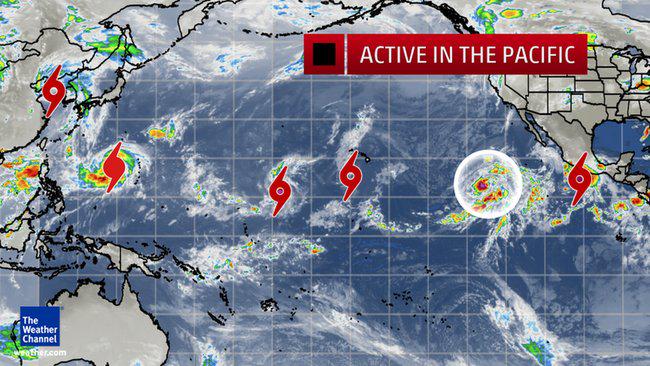
What a year so far. We have "El Niño" causing a very active hurricane season in the Pacific. According to arliest outbreak ever of 3 typhoons in the NW Pacific Ocean, breaking the old record set on 7/10/1972.

While this warming of the Pacific waters is bad for them...it keeps the atmosphere unfavorable in the Atlantic for hurricane formation. Forecasts indicate we could have a record hot "El Niño" event by late summer or early fall.


As a matter of fact, the present "El Niño", has already broken or tied the record for the warmest Pacific waters12 months in a row.

The record "El Niño" year was 1997 with an almost 7 degree warm up. (or 4° celcius above avg) .


What will this mean for us?:
  • Lets take a look at what is happening so far.
  • Major drought across California.
  • Record heat in the Pacific Northwest
  • Heavy flooding rains in the desert across Las Vegas
  • Now drought issues for South Florida.

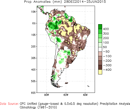
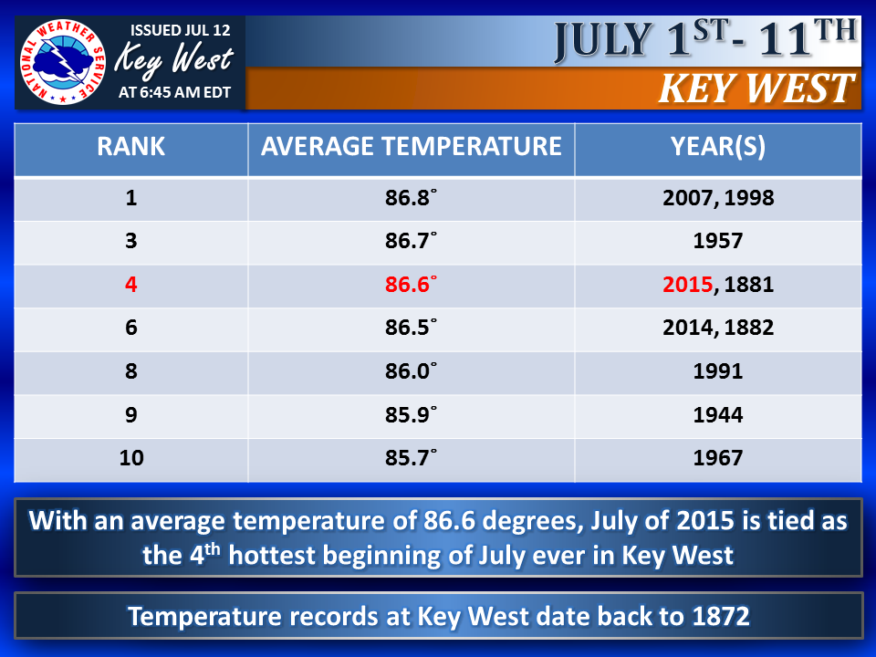
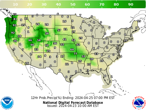
Check out the rain totals since the start of the year through July 8th.


Because we are running such a huge deficit, the National Weather Service has placed the metropolitan areas of Miami-Dade and Broward counties under Extreme Drought Conditions:


You can help conserve water by following the year round water restrictions:


((Broward has a clause for those properties who re-use water for irrigation. They can water all days except between the hours of 10 am & 4 pm.))

So we can see our climate is changing. Overnight lows which typically run in the upper 70°s have been in the low 80°s for weeks. And just last week we set record highs with temps in the mid 90°s.

Its hotter and drier now, and then... we will see an over correction in winter as Boston had last year. Mother Nature is always looking to achieve a balance but it is getting harder and harder for her to do it. It really doesn't matter what side of the Climate Change argument you are on, the bottom line is we only have one earth and we need to take care of her.

Footnote:
You will find very smart and talented people on both side of this argument. Its a shame it gets politicized. The fact is the world is getting hotter... the discrepancy arises when you try to determine if its a regular earth cycle or is it a man made phenomenon. It really doesn't matter, it will impact us either way. We must stop arguing and start working together to assure, not only our planet's health but the future of our children.