Tuesday, October 9, 2018

Major Michael


Hurricane Michael is poised to become a major System with winds over 111 mph sometime on Tuesday. 


Health Check 

The latest satellite loop is showing further intensification despite some shear in the upper levels of the atmosphere. Monday night the forecasters at the National Hurricane Center (NHC) said,  this strengthening under the present conditions "defies traditional logic".  Typically shear or strong upper level winds. help keep systems from developing or at least keep them in check. 

That hasn't happened with Michael. You can even see the eye forming northwest of Cuba. As of late Monday night it was roughly 35 miles wide.
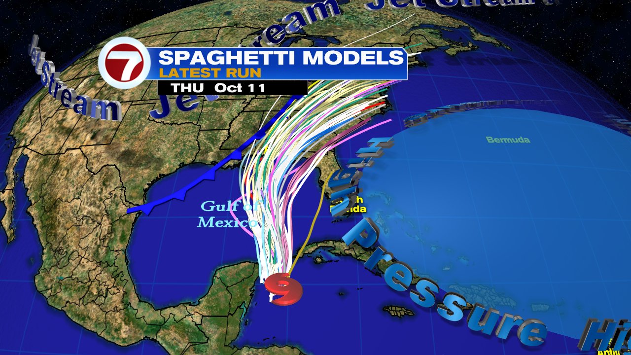
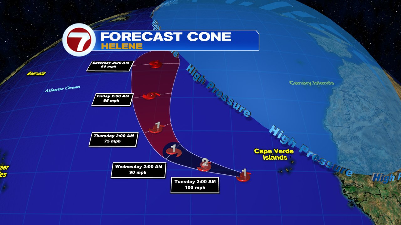
The Forecast Cone


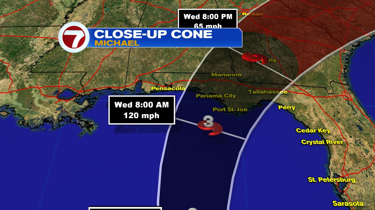
Michael will get steered into the Gulf of Mexico by high pressure in the Western Atlantic.  Most models weaken the shear over the next 24 hours. That fizzling of the shear along with very warm Gulf waters, will provide enough fuel for Michael to grow stronger. It could very well be a category 3 just before landfall across the Panhandle. Hurricane Warnings are in place for that area.
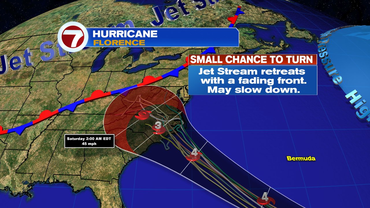
Wind Field


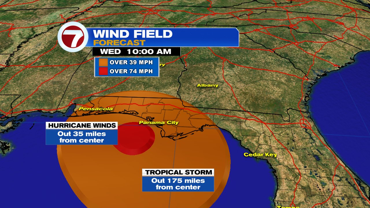
Hurricane force winds (74 mph +) extend out from the center 35 miles. Tropical Storm force winds, reach out from the center as far 175 miles.
If nothing were to change with its intensity, forward speed, or direction, the strongest winds should be near Panama City around noon Tuesday. Tropical storm force winds could possibly reach as Far East as Tallahassee and as far west as Pensacola.

Heavy Rain


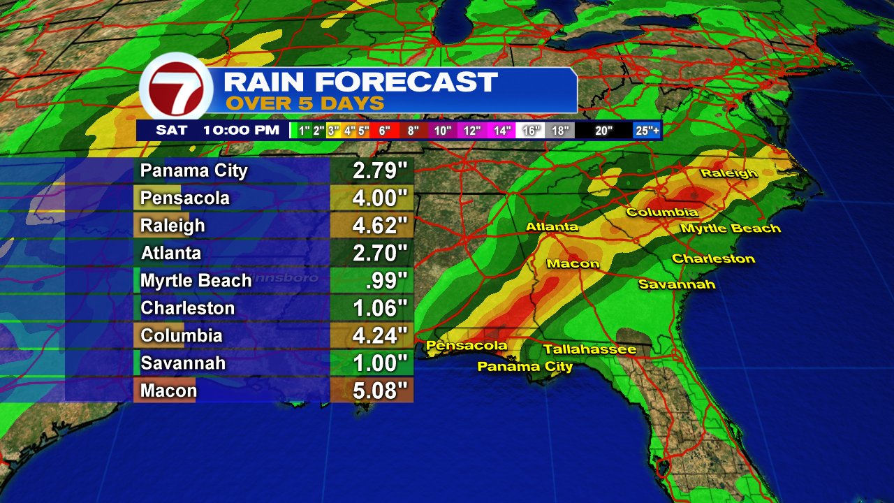
Michael is also capable of heavy rain. The highest amounts over 5 days will stretch from Pensacola Northeast into the Mid Atlantic States. The Carolinas do not need any more rain or flooding as they are just starting to clean up after Hurricane Florence.

South Florida Forecast


Michael's impacts on our area will be a tad difficult to forecast. As the storm gets stronger, its spin will pull moisture towards the center. This inward pull could drag all the rain away from South Florida. and thus keep us drier. But, moisture south of Cuba could make it all the way here and bring us on & off heavy downpours.


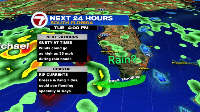
Our in-house model is not calling for much rain, but any that does make it here might be heavy enough to cause some street flooding. If we get any squally weather, winds could briefly kick up to 35 mph. 

At the beaches rip currents will be an issue.
Because it may be breezy, the wind could help our already high King Tides, get even higher. This will keep the threat of coastal flooding in place for the Beaches with a higher chance for the Keys.

We'll keep you posted


Monday, October 8, 2018

Hurricane Michael

Michael was upgraded to hurricane status at 11 am Monday morning by the National Hurricane Center (NHC), and is on pace to grow stronger as it aims for Florida's big bend.


While the general motion of the system is towards the Eastern Gulf of Mexico, hurricane hunters continue to indicate the center is still drifting East. The Florida Keys should continue to monitor the track of the storm. Even if it stays on a northward track, you will still feel its impacts.

Health Status:

It is looking more symmetrical. Since Saturday, the western side of the storm was still being hampered by shear, but as of this moment, the clouds are building to the west. This is an indication the shear is relaxing.


An eye is beginning to appear

Plenty of warm water for it to intensify further


Where is it headed?


The official cone from NHC, takes Michael into the Gulf of Mexico, then late on Tuesday, turns it into North Florida. It could make landfall anywhere between the Big Bend and the Panhandle. There is also a chance it could become a major hurricane, category 3 (111 mph winds), just before moving onshore. Everyone there should be preparing now. 

Once it makes landfall, the misery will not be over as models keep it somewhat organized as it moves across the Carolinas dropping more rain, something they do not need. They are still dealing with Florence's aftermath.

So why this track?


Tropical systems do not move on their own, they need something else to push it around. These are called steering winds. High pressure in the Atlantic, has winds flowing clockwise, while the jet stream over the nation's midsection with a trailing front, has winds flowing counterclockwise. The combination of these, will push Michael north and then northeast. A reminder the atmosphere is not stagnant and any deviation of the above can have a direct impact on the future track.

  • The following are the Most Important Points NHC wants you to know:
  • Michael is forecast to get stronger
  • Life threatening surge is possible along the West Coast of Florida regardless of where it makes landfall
  • Heavy rainfall may lead to dangerous flash flooding from the Big Bend to the Carolinas

All of the above can be expected
across Western Cuba and NE Yucatan.


South Florida impacts:
While the system may track to our west, its impacts will be felt hundreds of miles away from the center.

  • Coastal Flooding: High tides are already running higher due to the seasonal King Tides. Add to that gusty onshore winds from Michael, and minor coastal flooding is possible.
  • Rain:  Most of the rain is situated on the Eastern Side of the storm. If nothing changes on the track, the Keys, the Mainland and even the Bahamas could see on and off stormy weather. If the rain sticks over one area, it could lead to street flooding. The Keys may see 2 - 4 inches of rain through Tuesday.
  • Wind: There is a possibility that the wind could briefly gust up to 30 - 40 mph during any rain bands that move in.
  • Tornadoes: The ingredients will be present in the atmosphere for twisters to form through Tuesday.

We will be monitoring.


Sunday, October 7, 2018

Tropical Storm Michael aims for Florida

Tropical Storm Michael organized on Saturday just East of the Yucatan Peninsula.  By Sunday afternoon, a recon mission found the center to be closer to Cuba.  Tropical Storm Advisories are in place for Western Cuba and the Northeastern Coast of Yucatan.


The satellite imagery shows plenty of cloudiness over the Northwestern Caribbean Sea. There is plenty of moisture there and heavy rain is expected for the Western Province of Pinar del Rio in Cuba. Eventually, that rain will get displace over South Florida.

Where is it Headed?


For the time being, strong tropical storm force winds are only found in the area highlighted in yellow. High pressure across the Western Atlantic will keep Michael on a NW course until midweek when the high starts moving east. At the same time a front will move into Louisiana helping to push the storm into the Southeast. There is warm water in the Gulf of Mexico and that could provide enough fuel for the system to grow stronger.  There's also a possibility the center of Michael can regenerate a little further East on Monday and that could shift the cone closer still to Central and South Florida.


Most model runs are in agreement with the forecast cone from the National Hurricane Center (NHC) keeping Michael over the Gulf until midweek.

The three main points from NHC


  • Michael should be a rain event in the short term for Western Cuba and Yucatan Peninsula
  • Tropical Storm force winds of over 40 mph should move over the Yucatan Channel and into the Gulf Sunday night into Monday
  • Michael has a chance to grow into a hurricane by Wednesday 


Southeast Florida Mainland Impacts


Some of Michael's rain should start to move in overnight by way of its outer bands.
Isolated funnel clouds and waterspouts possible
Breezy to windy until Tuesday

Florida Keys Impacts

  • The system should travel around 300 miles west of the Island Chain. 
  • A flood advisory may be issued on Monday
  • On and off heavy rain bands. 70% chance of rain on Monday
  • Small chance for tornadoes
  • Localized flooding is possible. This means seawater intrusion across yards, docks, seawalls, and storm drains.


While South Florida may not see a direct strike, second hand impacts can be on the strong side. We'll be monitoring.


Sunday, September 23, 2018

Four things to watch this week in the Tropics

As we begin the first week of fall, the National Hurricane Center (NHC) is tracking two named systems and two others trying to organize. 


This satellite image shows a couple of swirls in the Atlantic Ocean, and a blob of rain near the Lesser Antilles. They are:

  1. Tropical Depression Kirk, in the Eastern Atlantic
  2. Sub Tropical Storm Leslie, in the Mid Atlantic
  3. What was Depression #11 near the islands

The First thing to watch is Kirk. 


It is not a good looking system with most of the rain found on the western side of the storm. NHC says this is probably due to drier air impacting the spin in the mid to upper levels of the atmosphere. 

Kirk will be traveling through warm waters over the next few days with little in the form of shear to weaken it. Shear is very strong upper level winds that can cut down the tops of developing thunderstorms, thus keeping it in check. Without it, Kirk is expected to get a little stronger (or at least keep it from reaching hurricane strength).

In the long run, the shear flowing from southwest to northeast, catches up with Kirk near the Lesser Antilles, and just like it took care of depression 11, here too it should take a toll on Kirk.

For the time being, the Bermuda high will steer Kirk west rather quickly, with a slow down expected in about 3 days, as the high weakens.

Spaghetti Models


The models have a consensus for the first few days that Kirk will travel mostly west but around days 3 - 4, they start to fan out. This is the time when the shear should move in. Some models think it will get tossed north into the middle of the Atlantic, while others suggest it may sneak underneath the shear and stay in the Caribbean.

The Cone


The official forecast track from NHC, bumps Kirk back up to a Tropical Storm through the Lesser Antilles and into the Caribbean Sea. From Trinidad and Tobago North through Guadeloupe, you need to monitor the progress of Kirk. Some gusty winds and rain may start to show up by midweek.

Once Kirk enters the Caribbean Sea, all interests there and even South Florida should keep an eye on it in case the models start turning it towards land. We'll keep you posted. Worry meter for So. FL is zero at the moment.

The second area to watch


Subtropical Storm Leslie will just be a nuisance for the Shipping Lanes.
A Subtropical Storm is a hybrid system, half tropical, half like an average low pressure you may find attached to a cold front.  It has a cold center instead of a warm one like regular hurricanes.

It has a nice spin to it, but notice the line of clouds moving into the picture in the upper left, that is a front and it is forecast to absorb Leslie in a few days. It may do a few loop de loops before being completely taken in by the front.

The third and fourth areas to watch


There are two other areas trying to organize in the Atlantic.

The one next to Subtropical Storm Leslie, has a medium chance for development in the area highlighted orange over 5 days. Even if something does develop it should end up just like Leslie, meandering in the Northern Atlantic.

Then there's another area just South of Bermuda with a medium chance to develop. If it does, it should organize in the orange area. This one is worth watching because even if it doesn't organize it could drop more rain across the Carolinas.  If it does develop, it would be an awful mess to have the Mid Atlantic states hit by another tropical system. Hoping for the best there.


Tuesday, September 11, 2018

Fierce Florence

There's nothing left to say to folks living along the coast of South & North Carolina... "Get out of the way!"

Hurricane Florence remains a ferocious category 4 system with winds of 140 mph.


It 's well organized, good feeder banding, a well developed eye and nothing in its way to debilitate it.

The National Hurricane Center is using words in their storm advisories like, dangerous, life threatening, and catastrophic. This in not code and they are not sugar coasting it. This will be a killer storm.

You need to get out of the way.


The cone of concern shows the system making landfall on Thursday and then weakening inland. It will slowly weaken across the area dumping a lot of rain.


This is the reason why it will stall over the region. A cold front with a dome of high pressure moves in trapping Florence for a few days. Eventually the front will push it out over the Northeast.


Rain forecasts indicate anywhere from 1 to 2 feet of rain widespread, with a few spots seeing as much as 4 feet through next Tuesday. This will lead to catastrophic flash flooding.


Our impacts from Florence will be in the form of rough surf mostly for Palm Beach and Broward Counties with up to 5 foot waves.


Tropical Storm Isaac is also on pace to make landfall across the Lesser Antilles, but it's looking more and more disorganized. The winds came down at the 11 pm advisory from 70 mph, to 65. 


Having said the, the National Hurricane Center keeps it as a storm through much of the Caribbean Sea. Coastal Haiti, Dominican Republic and Jamaica should monitor closely.

These are just two of the five areas NHC is watching.


There's also Helene. It should weaken across the Northern Atlantic in the days ahead. It may brush the Azores towards the end of its life cycle.


Then a vigorous tropical wave near the Yucatan Peninsula has a high chance for development. A 70% chance it could develop into a depression or a storm in the area highlighted. 


These very early model runs are just giving an educated guess since nothing has developed yet. But if it does, they are trending the track towards Southern Texas. Mexico and Louisiana should monitor as well.
 

 Then an area in the middle of the Atlantic with nothing there now, has a 50% chance for a system to develop over a period of 5 days.

We'll be monitoring.


Monday, September 10, 2018

Monster Florence aiming for the East Coast

Hurricane Florence is a major system with winds of  140 mph, as of the Monday night advisory.

Everyone along the Mid Atlantic States should be getting ready.


Major Hurricane Florence


Earlier Monday afternoon, the eye of Florence measured roughly 10 miles wide. A category 4 system churning in the Western Atlantic. You can see the tube heading down into the surface. That is the eye wall, where you find the strongest winds and heaviest of the rain. It's a ring of destruction that will pummel whichever area it runs into.

Florence's Vital Statistics


The area where you will find tropical storm force winds from 39 to 73 mph, extends out from the center 150 miles.


 The area where you will find hurricane force winds from 74 to 140 mph, extends out from the center 40 miles.


 The system itself is 450 miles around.

Where is Florence Headed?


The system will aim for the Carolinas as a category 4 with the potential to get a little stronger before landfall. Notice the bulge at the end of the cone. That suggests it may stall across the region dumping plenty of rain.

Spaghetti Models


They actually show the system doing loop de loops along the coast, blocked by a dome of high pressure and cold front. This will keep the threat of torrential rains in place for days.


Some areas could see as much as two feet of rain which will lead to flooding, land and mudslides.

More Activity in the Tropics


 We are also following:

  • Isaac downgraded to a Tropical Storm
  • Hurricane Helene
  • A tropical wave in the Caribbean
  • And a potential are of low pressure in the Northern Atlantic


Isaac will steer toward the Lesser Antilles. The small size of this system is making it difficult to forecast its intensity. It could get a little stronger and just as easy weaken. The Lesser Antilles need to monitor.


Hurricane Helene will move north and may eventually impact the Azores with gusty winds and squally weather.


In the Western Caribbean a tropical wave is meandering. It should move into the Gulf of Mexico where it will have a 60% chance for development in the area highlighted.


Then in the Northern Atlantic, nothing is there now, but NHC says that an area of low pressure may form over 5 days. That has a 50% chance for development.

We'll be monitoring.

Sunday, September 9, 2018

Stronger Florence moving faster. Isaac on a steady pace for the Lesser Antilles.

"Life threatening impacts from Florence" Remains the message the National Hurricane Center (NHC) wants everyone to hear as the hurricane aims for the U.S. East Coast.


Florence's Vital Statistics as of Monday morning:

  • Winds: 105 mph - Category 2. It's forecast to get even stronger. Hurricane force winds extend out from the center 25 miles. Tropical storm force winds reach out 125 miles from center.
  • Pressure: 969 mb. It was 984 mb Sunday afternoon. That's a drop of 15 mbs. The lower the pressure, the stronger the system.
  • Storms: Plenty of thunderstorm activity around the center. 
  • Any shear?: Very little 
  • Outflow: Firmly in n place. Hurricanes take in moisture at the base in a counterclockwise fashion. That air is then released in the upper levels of the atmosphere in a clockwise motion. When this happens, you have a fine tuned tropical engine at work. Notice the satellite loop as the spin moves inward at the center, but at the top of the image, the spin is opposite. This is your outflow at work. Impressive.


Where is it headed?
Spaghetti Models:


The main grouping is now showing a more unified consensus that Florence will aim for the Carolinas. There are outliers on both sides, but NHC's cone of concern is following the clustered grouping. NHC is also warning that the models are suggesting a larger wind field that could impact the coast many miles away from the center.

Models are also indicating a faster forward speed in days 3 - 4 of the forecast which unfortunately "increases the risk of a destructive hurricane landfall"' according to NHC.


NHC says, "the major impacts from Florence will be wind, storm surge at the coast, heavy rain leading to flooding from the beaches to far inland locations. Everyone from the Carolinas northward should pay attention and prepare.

More NOAA and Air Force Hurricane hunter missions are scheduled .


The other system capable of landfall is Isaac.


As of 11pm Sunday night, here are the vitals:


  • Winds: 75 mph. Isaac is now a hurricane.
  • Size: This a small and compact storm. This can play both in its favor and against its overall health.
  • Storms: While there isn't impressive feeder banding, it does have plenty of thunderstorm activity around the center. Drier air is keeping it in check for the time being.


Where is it going?
Spaghetti Models:


NHC warns that the models do not have a good handle on this system. The GFS and European models keep Isaac on a steady westward course increasing in forward speed, while the UKMET and HWRF suggest a slower moving storm with a possible jog to the north. This is evident on the fanning out of models in the spaghetti chart.

Official Cone of Concern


The cone keeps Isaac heading west.  The size of the system may play a big factor in how strong it may be once there.

Low shear at the moment will allow it to gain strength, specially as it moves over warmer waters. It will take full advantage of this situation to intensify. But as it gets close to the islands, strong shear will show up and because of its small size, it should weaken rather quickly. The GFS model weakens it the most, down to a lowly wave. We hope that is the case.

A change in the intensity forecast. NHC says it may be a category as it nears the Lesser Antilles instead of Category 2.  The strength outlook will fluctuate in the days ahead due to its small size.    Still too many variables with Isaac. Please monitor and prepare now.


The National Hurricane Center is watching:


  1. Hurricane Florence
  2. Hurricane Isaac
  3. Hurricane Helene
  4. An area of concern in the Gulf of Mexico
  5. An area of concern in the Mid Atlantic


Quick Tropical Scan

  • Helene should stay in the open waters of the Atlantic 
  • An area of concern in the Gulf has a 30% chance for development in the area highlighted in yellow over 5 days.
  • An area of concern in the Mid Atlantic has a 40% chance for organization in the zone highlighted in orange over a 5 day window. This will be interesting because it promises to move southwest in the long run.


With all these system to watch, NHC is extremely busy.


We have to go back to last year to find three hurricanes in the Atlantic Basin. On September 6th, we had Katia in the Gulf of Mexico, Irma northeast of the Leeward Islands, and Jose in the mid Atlantic Ocean.  We are at the peak of hurricane season, today September 10th.


We'll be monitoring