Tuesday, September 29, 2015

Bahamas Hurricane Threat?

T.S. Joaquin is aiming for the Bahamas and getting stronger as of Tuesday night.


Satellite imagery suggests its getting well organized with feeder banding starting to show with some outflow being detected in the upper levels. Most of the models suggest additional intensification over the next few days.


Already the Southeastern Bahamas are getting some rain associated with this system.

"Joaquin" will prove to be a "Nerve-Tester" as it may reach 90 mph winds by Friday as it nears the Central and Northwestern Bahamas.

Then most models stop it on a dime and push it due North keeping it over the Atlantic Waters.

After that dead stop, the models fan out with some taking "Joaquin" into the Mid Atlantic States and others as far east as Bermuda.


The reason for this sudden stop and turn is due to a front being pushed along by the Jet Stream.

This combo will act as a wall deflecting the storm from the Bahamas. BUT, it may be a close call, everything depends on how fast the jet and front move down.


  Two things can happen, Scenario #1:

If the Jet and associated front are too slow moving south, this will allow for "Joaquin" to possibly impact the Bahamas.

It could be a 90 mph hurricane by then or maybe stronger. Intensity forecasting is not precise and it has a chance for further growth. 


Scenario #2:
If the jet/front move in fast enough, it should deflect "Joaquin" north keeping it away from land, at least for the short term.  We'll be watching.


Monday, September 21, 2015

Going Loony for rare Super Lunar Eclipse


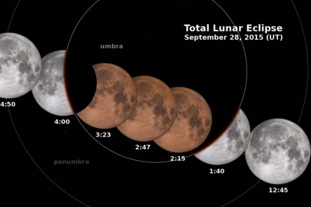
This upcoming weekend you will witness a very cool lunar eclipse. Don't miss it because the next one won't take place until 2033.
 
Lunar eclipses are not that rare, but what makes this one unique, are three celestial events tied into one.

First you have a full moon, second a lunar eclipse, and third , all this takes place when the moon is closest to the earth. The moon's orbit is not circular but elliptical, this means its closer to us at times and farther at others.

The last time this "Supermoon Eclipse"  happened was in 1982; there were just five instances of it in the 20th century.

With these three features in place, it should be a  very cool event to witness.

So what can we expect:
  • The moon will be fully lit in all its celestial glory, a full moon this weekend.
  • The lunar eclipse happens on Sunday September 27th. This is when the earth blocks the sun's light from hitting the moon. In essence the earth's shadow will cover the moon.
  • Lastly, all this takes place during lunar perigee, when the moon is in the closest part of its orbit to Earth.(also known as a Supermoon)

The following is from Space.com
During lunar perigee, the moon appears larger and brighter in the sky, which is why a full moon coinciding with perigee is known as a "supermoon." (A "minimoon" is when the full moon is at its farthest point from the Earth.) This large moon will present the perfect canvas to watch the Earth's shadow slide over and block the moon's light. 

The moon will be shrouded in shadow Sunday night or early Monday morning.
It will enter the dark part of the Earth's shadow at 9:07 EDT Sunday, and it will enter a total eclipse by 10:11 p.m. EDT  before it begins to emerge from the shadow 12 minutes later. 
Areas that cannot see the full eclipse, because sunset comes too late or sunrise too early, may still be able to see part of the moon obscured.


And if that wasn't enough:
This eclipse carries another name as well, "Blood Moon"
The moon doesn't simply disappear into Earth's shadow during a lunar eclipse; instead, it's illuminated by an eerie, reddish glow of the light refracting through the edges of Earth's atmosphere.

Check out this explainer video, again courtesy of Space.com:
Click here for a quick video of the Lunar Eclipse


Wednesday, September 16, 2015

New Depression # 9 plus loss of Arctic Ice

NHC is watching two areas in the Tropics. One is a depression, the ninth of the season, and the other a low in the Far Eastern Atlantic with a good chance for growth.

Tropical Depression #9
Is roughly 1200 miles East of the Lesser Antilles. Top winds as of this posting are at 30 mph and it is moving slowly to the NNW at around 8 mph.

Its not looking too healthy on satellite imagery. Strong upper winds are impacting it already and most of the rain is to the east of the center. This feature may not last too long.

Most models keep this depression over the open waters of the Atlantic. NO Worries for Us or the Lesser Antilles.


There is another broad area of low pressure near the Cape Verde islands which continues to get its act together.

Its roughly 400 miles SW of the Cape Verde Islands.

Over the next few days, the atmosphere surrounding this low will become favorable for growth.

It could become a depression/storm over the next 5 days.

This is what NHC is saying about it:

They are giving it  an 80% chance for development over the next 5 days. Even if it develops, models here too keep it as a worry only for the shipping lanes. 

The models project its path almost following
the footsteps of TD #9.

No worries for the islands, nor for us
here is South Florida.


Meanwhile, we are losing Arctic Ice very fast. A new NOAA reports a record loss coming in, in 4th place among the worst ice losses since the 70's.

This is their update:

Scientists report (today, 9-15-2015) that the Arctic sea ice summertime minimum is 4th lowest on record.
 #1.  Analysis of satellite data by NASA and the National Snow and Ice Data Center indicates that the accelerated summer melting trend since the late 1970s continues.
 #2.  This increased melting is a response to the warming global temperatures.
 #3.  It is unclear whether this year's strong El Niño has had any impact on the Arctic sea ice.
Tag:  Weather and climate researchers are continuing to study the possible effects of 
the increased open Arctic waters in the autumn might have on jet stream patterns over the United States and snow storm development in the winter season.

Friday, September 11, 2015

Strongest El Niño ever?

We've heard a lot about "El Niño" this year. This is a warming of the Equatorial waters of the Pacific Ocean that not only impacts marine currents, but atmospheric ones as well.

It has a global reach...rainy where's it typically dry and vice versa. It also helps keep hurricane formation in check in the Atlantic basin. Strong upper level winds ride out of the Eastern Pacific only to cut down the tops of any developing system on our side of the world. For us in South Florida,"El Niño" is our Tropical Friend.

Forecasts have been calling for a very strong "El Niño" this year, maybe even a record setting event.

NOAA says:
The three-month, June-August average of sea surface temperature ran 1.22°C (About 2 degrees F) above normal.
This is the third-highest June-August value since records started in 1950, behind 1987 (1.36°C) and 1997.

The "El Niño" event of 1997 was one of the strongest on record. This image shows a side by side comparison on 1997 and now.
 
NOAA adds that:
“There is a greater than 90% chance that El Niño will continue through Northern Hemisphere winter  2015-16, and around an 85% chance it will last into early spring 2016.”

The red tones indicates hotter temps, while the blues show cooler water temps. Typical temps are in yellow.

So what does this mean?
A strong "El Niño" during the winter typically means wetter weather for the West Coast. This could mean much needed rain for California and its drought.

It could also mean land and mudslides with very strong gale force winds.


For South Florida?
El Niño conditions usually bring cool and wet conditions to our region, specially from December through February. 


These are the possibilities of a Freeze for the counties in Florida during an "El Niño" year.


  We'll keep you posted on the progress of this Possible Record Setting El Niño.


Monday, September 7, 2015

Steady pace "Grace"

Tropical Storm "Grace" is moving due west looking healthier as of Monday morning, but this may not last too long.

Satellite imagery shows:

  • Plenty of rain around its center. This usually means a well organized system
  • Satellite pictures also captured more rain in a couple of feeder bands. Feeder bands are those long spiral cloud bands that soak up all the heat energy from the ocean and transfer it to the center. If this process continues , then "Grace" should have no problem getting stronger

This growth spurt may not last long:
The same satellite imagery shows that shear is starting to make a move on "Grace".

Shear, is when strong opposing upper level winds cut the tops down of thunderstorms growing in the storm. This can weaken a system or sometimes kill it all together.

This year we've had more shear in the Atlantic Basin from "El Niño". This warming of the Pacific Ocean has made hurricane activity very difficult in the Atlantic. Most systems since Danny have been shredded by these strong winds. We can expect the same with "Grace".

This current "El Niño" event , is on its way to become the largest ever. If you want to know more click on this link.  What is "El Niño"? 

Here is a look at the latest model runs. They are working on the assumption "Grace" will survive the increasing shear.


What's next for "Grace"?
Most models agree it will continue to aim for the Lesser Antilles as a Tropical Storm, but the shear will increase. NHC says,"Environmental conditions are forecast to become less favorable by tonight as westerly vertical wind shear increases and dry mid-level air over the tropical Atlantic impinges
on the circulation. "

This means "Grace" will have a hard time dealing with those opposing upper winds and so it should weaken as it nears the islands. "Grace" may even fall apart completely.

This would be good, no one wants to be hit by a storm, but they sure could use some rain. Much of the Lesser Antilles remain in drought status.

For the latest Advisory click on the link below:
Latest on "Grace"l

Sunday, September 6, 2015

Lesser Antilles Eyeing Grace

A typical "Cape Verde" systems is chugging along in the Eastern Atlantic and aiming for the Lesser Antilles.

For you with family and friends, or those in the forecast path of "Grace", there is an uneasy feeling in your gut right now.

About a thousand miles to the east lays Tropical Storm "Grace" gaining strength and moving due west.

Satellite Imagery:

  • Shows more thunderstorm activity
  • Its looking better organized, with better banding, and what appears to be a well defined inner core.
  • The low level center is located further south than in previous advisories and NHC adds, "Grace is  well organized...(and its) intensity could be conservative."

The reason why the southward jog of the center is worrisome, is that its path will remain almost in a straight due west trajectory, with the islands in its sights.

As large and as strong as tropical systems can be, they don't move by themselves. They need something even larger to push them along and in this case its the Bermuda High.

This huge dome of high pressure has winds moving from West to East. These winds will keep pushing  "Grace" on a consistent course for the next 5 days.


The environment surrounding "Grace", has little shear. These are opposing upper level winds that help cut down the tops of developing t-storms and help keep storms in check.

These winds will remain weak over the next few days giving "Grace" a chance to grow stronger.

By days 4 and 5 of the forecast, NHC thinks the shear will get stronger and weaken "Grace" considerably.

Forecasting strength is the most difficult thing to do. The science is just not there. NHC is trying very hard with new technology to figure out a way to improve this, but for the moment its still illusive. This is why The Lesser Antilles should watch the progress of "Grace" this upcoming week.

For the latest National Hurricane Center advisory click on link below:
Update "Grace" advisory


Saturday, September 5, 2015

New Depression #7

Cape Verde season is in high gear and a new depression, number 7, has formed off the west coast of Africa as of Saturday morning.

For the latest advisory on this system click on the link below:
Advisories from National Hurricane Center

We've been following this robust wave even when it was still over land.  Satellite imagery showed it was getting its act together with more banding and thunderstorm activity.
Even though there is some rain, its not that heavy, but it does have a good spin to it.

Special satellite data was used to detect circulation found in the mid levels of the wave, indicative of a developing depression.

NHC contacted ships near the area and confirmed it had stronger winds and thus this wave has now been upgraded to Tropical Depression Seven.

The surroundings of this depression seem to favor slow strengthening over the next few days while it stays in the far Eastern Atlantic. Its about 300 miles SSW of the Cape Verde Islands.

Models suggest it will continue to move almost due west for the next 5 days being pushed along by high pressure to its north. There is very little shear or strong opposing upper winds to keep it in check so it could become Tropical Storm "Grace".


In about 4 to 5 days the models indicate strong upper level winds will develop, slowing the system down and possibly weakening it. High pressure will move north allowing "Grace" to also make a turn for the North-Northwest.

This combination of strong shear and a jog to the north may just be enough to knock it out. This is what NHC says regarding the long term outlook:

Most of the global models forecast a significant increase in shear. This should halt any additional strengthening, and most likely the cyclone will weaken or could even dissipate well east of the Lesser Antilles.

This is the official forecast cone from NHC:

Hopefully this will just remain a worry for the shipping lanes.