A tropical wave sitting over the Southeastern Bahamas is loaded with moisture and set to arrive very early Monday morning. Coastal South Florida has already seen brief heavy downpours and more will pop up until the bulk of the rain moves onshore.

This is the radar out of the Local NWS Miami office. It is monitoring the rain moving our way.
Timing of the rain:
The disturbance itself is highly disorganized so an exact time is not possible. The following time frame are estimates, based on the wave moving our way between 17 - 23 mph.
Rest of Sunday: On and off downpours, some can be very heavy leading to difficult driving conditions. The wind will pick up gusting to almost 30 mph during the strongest of the downpours.
Monday, Labor Day: A blending of the models gives us an estimate for the heaviest rainfall to occur between 2am and 2 pm. With the wave itself directly over us around noon. Because this wave will cause plenty of instability, or shake up the atmosphere, the following can also happen:
- Waterspouts
- Gusty winds up to 35 mph or greater
- Tornadoes
- Street Flooding

A flood watch for South Florida may be implemented later today.
This wave may cause rainfall to track over a specific area and keep pouring for hours. This is known as "Training", and it can lead to standing water. The local NWS office will be monitoring carefully and may issue such a watch.
The latest forecast amount for total rain is between 3 - 4 inches from Today through Monday.
Once in the Gulf of Mexico

The wave, seen on satellite imagery as the area of clouds over the Bahamas, is being kept from getting stronger by shear. These are strong upper winds that help cut down any developing thunderstorms. but they will weaken or fall apart once the wave enters the Gulf of Mexico.
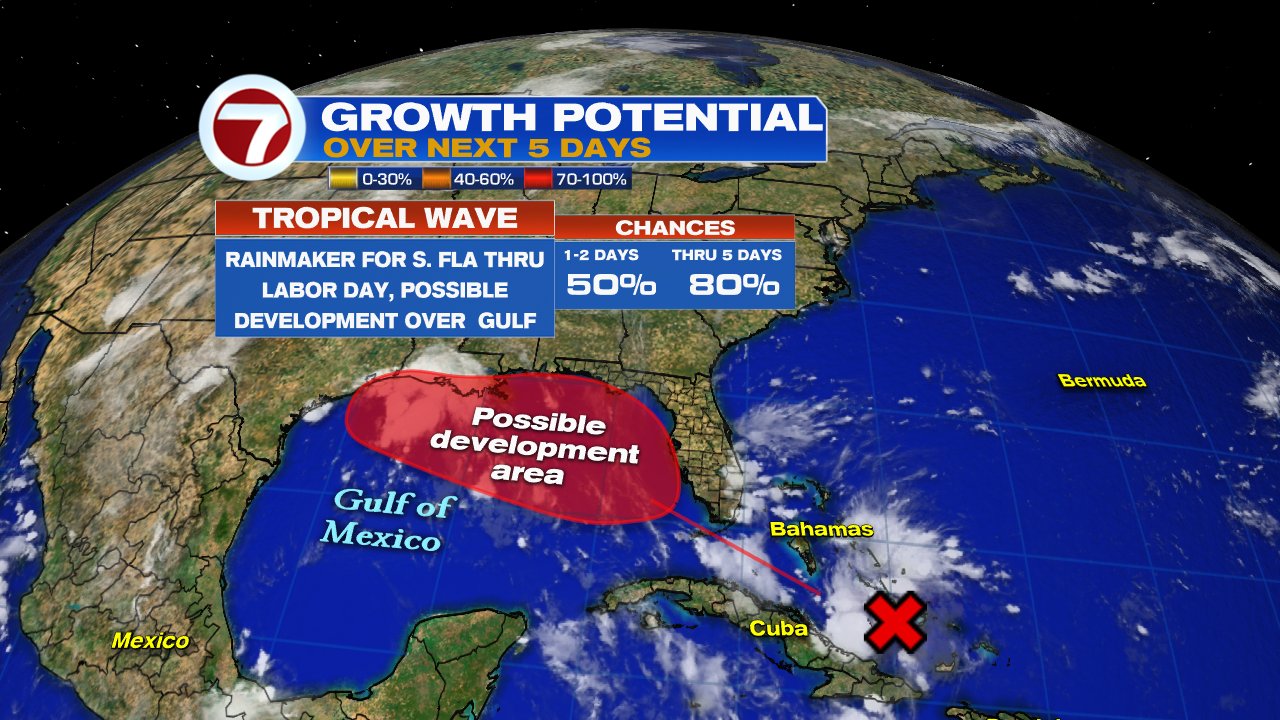
The National Hurricane Center (NHC), is now giving the wave an 80% chance that it can develop into a depression or a storm in the area highlighted red over a period of 5 days. Possible organization is most likely Tuesday or Wednesday. South Florida may still get some on and off rain from this, however, the worry then turns to the Gulf States.
This wave has been deemed Invest 91L. This stands for and area NHC would like to INVEST-igate further, 91 is just a tracking number, and "L" stands for the Atlantic Basin. This now allows NHC to call for a recon mission to be on stand-by if needed.

The very early spaghetti models suggest movement towards Mississippi, Louisiana, or Eastern Texas. These are very preliminary, but give a heads up to areas down the road to start paying close attention. If this wave develops into a tropical storm, it will be named "Gordon".
We'll be monitoring.
No comments:
Post a Comment