Satellite View

As of Monday morning, it remains a disorganized wave with just scattered areas of shower activity. NHC does not expect any organization of this wave over the next couple of days but caution that the environment surrounding it could become favorable for development by the time it nears South Florida and Northwestern Bahamas.
Development Chances

The mountains of Hispaniola should keep the wave in check as well as some strong upper level winds known as shear. This combo will not allow the wave to get its act together. By the time it leaves Eastern Cuba, it will have a better chance to grow.
On Alert in Dominican Republic

An alert notice has been issued in Dominican Republic for the possibility of heavy rain over the next few days due to the passage of the wave.
The government suggests possible heavy rain with plenty of lightning strikes and even gusty winds expected to arrive by Tuesday and remain through Wednesday.
Everyone there should monitor the progress of this tropical wave.

As of this writing, NHC is giving this wave a 20% chance it could be a depression or a storm once it nears South Florida/NW Bahamas, by the upcoming weekend.
Spaghetti Models

NHC is calling this wave Invest95L. Invest for an area they would like to INVESTigate further, 95 is a tracking number, and "L" stands for the Atlantic Basin. You have probably noticed overtime when there's a new Invest, the number goes higher. The next one will be Invest96L. Once NHC reaches 99, they reset to 90.
There are only a handful of early models trying to decipher where the wave will end up, but most lineup more or less with the yellow formation area depicted above. Remember, that area highlighted is NOT a cone, but where NHC thinks the wave may develop.
South Florida Impacts
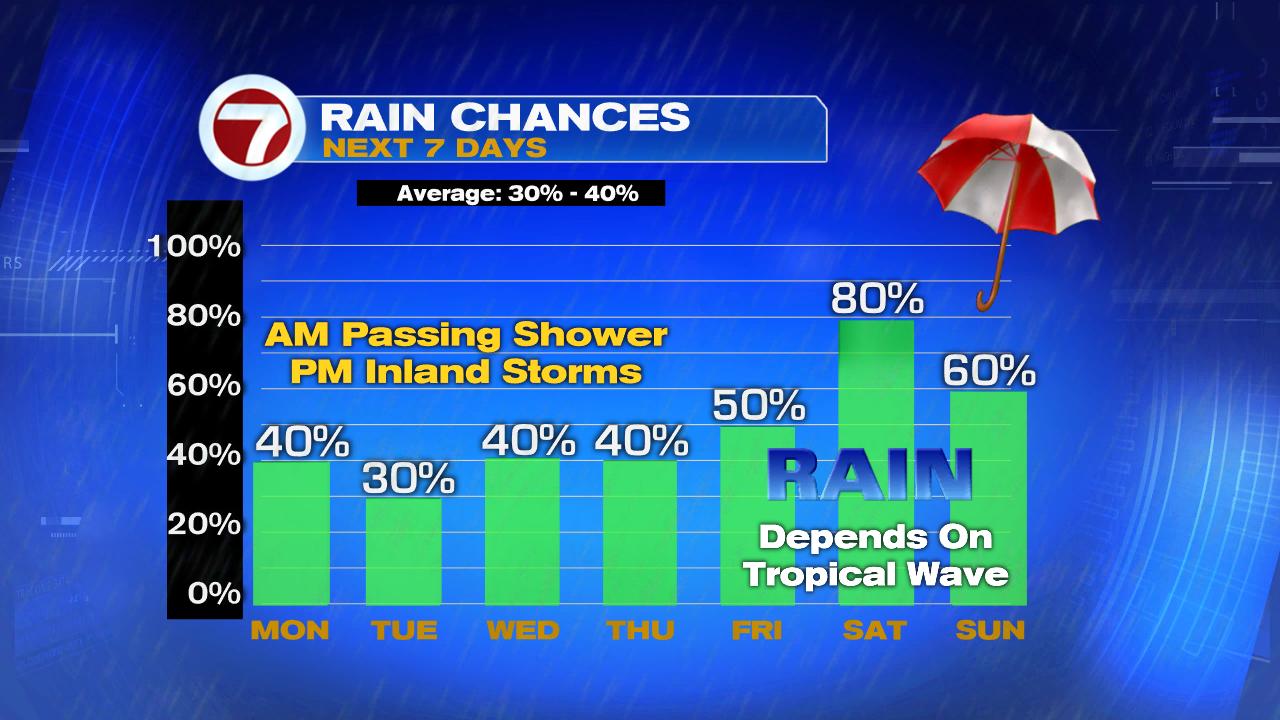
Even if it stays a tropical wave once over us, it is capable of heavy rain. It could also grow stronger so you should be ready for that possibility. Review your supplies and make sure you have what you need now in case Mother Nature wants to play rough.
We'll be monitoring
Praying it does not strengthen.. and stays away from us.. except for some rain.... everyone watch this
ReplyDeleteKeep fingers crossed as well.
ReplyDelete