Tropical Storm Dorian may be a category 1 system with winds over 73 mph as it nears Florida by the weekend.

Dorian is trying to get its act together. As of early this morning, the system looked somewhat disheveled with most of the storms (highlighted in the yellow, oranges, & reds), sitting to the north of the center of circulation, yet as of 2 am the winds managed to kick up to 60 mph. They were at 50 mph for much of the day on Tuesday. The southern half of the system remained mostly dry.
There is also plenty of dry air around the storm starving it for moisture, as well as some light shear (strong upper winds that can cut down developing thunderstorms within Dorian) still ahead of it.
Where is it Going?

- This is the official forecast cone from the National Hurricane Center (NHC). It suggests that by late afternoon/early evening it could make landfall across SE Puerto Rico with winds around 60 mph. It is capable of dropping up 4-6 inches of rain with some areas getting as much as 8. This will surely lead to flooding.
- The big question is what will happen after wards. Depending on how long it travels over land, it may emerge a tad weaker into the Atlantic Ocean. But with less shear there and moving over some very warm waters, it has the chance to grow into a category 1 hurricane with winds over 73 mph by Friday.
- The center may avoid the Turks & Caicos, as well as the SE & Central Bahamas. You may still get some thunderstorms and gusty winds but no direct hit (as of 11 pm Tuesday night). The cone and intensity may change again today.
- By Friday it is forecast to become a hurricane and start moving west as high pressure moves in form the East. DO NOT FOCUS on the little "H" by Daytona beach, the center of Dorian can be anywhere in the area highlighted, from Miami-Dade north to SE Georgia over the weekend. We should have a better idea of the final track and intensity by Thursday.
Models
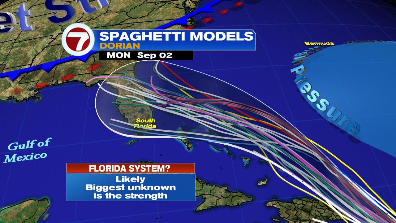
There are dozens of models that are in fair agreement the system will aim for Florida. Each model may look at different criteria. The bottom line is that each one of the lines can have a hundred mile margin of error on each side. That is why it's important to look at the cone where all the models are averaged out. There is no such thing as a perfect model. If you are in the cone, you need to prepare. And even if you are outside of it you may still get some squally weather.
While Dorian may be a Cat 1 as it approaches Florida, intensity forecasting is extremely difficult. Many factors like water temp, land interaction, and blowing winds in the upper levels of the atmosphere, can influence how weak/strong it may be. The atmosphere is in constant flux and so the strength of Dorian may change before its arrival. Everyone across the Bahamas & Florida should monitor.
Watches & warnings may be issued for parts of South Florida later this week. Review your supplies now and be ready in case Dorian decides to pay us visit.
We'll be watching
No comments:
Post a Comment