Tuesday, September 10, 2013

The Peak of Hurricane Season

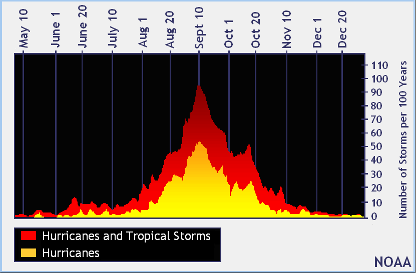
September 10th marks the high point of hurricane activity in the Atlantic Basin, the midway point if you will of the season.  Lets hope the second half is just as quiet as the first.

This year has been rather dull in spite of all the high projections made at the start of the season.

So far we have seen 8 systems and all have been tropical storms, yet there is something interesting about the system we are presently tracking.

The Latest "First Hurricane"
The latest "first-hurricane" to manifest itself during the satellite era was Gustav on September 11th of 2002. It reached hurricane status at 8am.

As of Tuesday morning, Tropical Storm Humberto is in the Far Eastern Atlantic trying hard not to make history. It is forecast to become a hurricane later today keeping the old record intact. We'll be following closely.


This is the forecast track for Humberto:


Back from the Dead
Something else we are keeping tabs on is Gabrielle, back from the dead.  NHC says the remnants have regenerated and are back as a tropical storm aiming for Bermuda.


This is the forecast track for Gabrielle:


Sunday, September 8, 2013

Could we see the 1st Atlantic Hurricane for 2013?

It has been a rather quiet year as far as the tropics are concerned. There have only been 7 systems named and none have reached hurricane status. This is great news.

Now we start the work week with a brand new depression that promises to intensify rather quickly and maybe reach hurricane intensity by Wednesday.


This is Tropical Depression #9. NHC has had it in its sights for quite a while monitoring it for days, even before it moved off the West Coast of Africa.


Models indicate it may become Tropical Storm "Humberto" on Monday and maybe reach hurricane strength by midweek. It will impact the Cape Verde Islands with some wind and rain, but after that it should only be a worry for the shipping lanes.

HURRICANE FACTOID
If this season ended with just one hurricane, it would rank as one of the most hurricane free years in recorded history.

Here are some of the most notable seasons:
YEAR              NUMBER OF HURRICANES
1925                                     1
1905                                     1
1914                                     0
1904                                     0

Of course back then there were no satellites, so the possibility exists of many storms having gone undetected.

REALITY CHECK:
We are almost at the halfway mark for the season. The peak of activity is the 10th of September, so there is still a second half to go. NHC still expects more systems to develop in the coming months, so please do not let your guard down. But wouldn't it be great if we were to finish with a quiet year? Keep those fingers crossed.

Thursday, September 5, 2013

Watching 5 areas, including Gabrielle

Tropical Storm Gabrielle formed from an area of low pressure in the Eastern Caribbean Sea on Wednesday. Since its birth, it has not looked impressive on satellite imagery.

Most of the alleged tropical storm force winds remain tightly packed near the illusive center of circulation.  At times there have been moments and flurries of activity that suggest strengthening, but most of the thunderstorms are to the Northeast of the center.

It does have good outflow in the upper levels, but for the time being, there are no signs of further organization.

Meanwhile, the center is getting harder and harder to detect.

NHC sent a recon plane to get a better handle on this system and as of Thursday morning, Gabrielle has been downgraded to a depression.


FUTURE TRACK:
Where it will go if it survives is more certain.

High pressure to its East and the jet stream to its NW, will carry what is left of "Gabrielle" northwest and into Hispaniola


For now, the islands will be dealing with tropical downpours.

IN THE SHORT TERM:
Heavy rains continue across Puerto Rico.

  • A Flash Flood warning is in place 
  • 3-6 inches of rain are possible through Friday, with some areas getting as much as 12"
The Dominican Republic is on alert as they too may get heavy downpours

  • A land and mudslide watch is in place

MORE ACTIVITY:
Besides weak Gabrielle, there are four other areas NHC is watching.


From the Gulf to the Atlantic:

  • There is an elongated area of low pressure in the Bay of Campeche.  Because it is moving over warm waters, NHC gives it a 30% chance it could develop into a depression or a storm as it aims for Central Mexico.
  • Right next door to Gabrielle is a Tropical Wave . NHC gives it a 20% chance that it could turn into a mature tropical system in about 5 days. Right now, its proximity to Gabrielle is hindering its growth potential.
  • A Tropical Wave roughly 500 miles West of the Cape Verde islands is showing some signs of life. NHC keeps its chances at 10% over the next 5 days.

But we are not done: (NOT PICTURED) Most models suggest a disturbance over Africa will move into the Atlantic waters in a few days with a decent chance for organization. NHC is already giving it a 30% chance for growth once it moves into the Eastern Atlantic waters.


Wednesday, September 4, 2013

Invest 97L

NEW AREA TO WATCH:

There is an area of disturbed weather by the Lesser Antilles that NHC is keeping tabs on, they have deemed it invest 97L, (Invest for an area they would like to investigate further).

As of this moment there is plenty of clouds and rain covering much of the Leeward Islands.

Puerto Rico should see some of that rain on Wednesday.

This feature has a moderate chance for development, but in about three days, those chances may go up higher.


HEAVY RAIN EXPECTED:

This is the latest from the Puerto Rican Weather office:

A Flash Flood Watch is in effect for all of Puerto Rico including the US Virgin Islands until Friday.

Heavy rain can be expected through Wednesday night.

Total rainfall may reach between 3-6 inches leading to localized flooding, land and mudslides.

MODEL FORECASTS:

Where it may end up will be determined by the Bermuda High, whose long range tentacles reach into the Caribbean, Cuba and Florida.

If this high stays put, then the disturbance will move due West across the Caribbean Sea. If it weakens and moves East, then the clouds and rain will move towards the Bahamas.

If this second scenario holds, then we may see some rain here by the weekend.

The models are split about 50-50 on what will happen with 97L. A recon plane is scheduled for Wednesday, in order to get a better idea of the disturbance's structure and health.


Monday, August 26, 2013

T.S. Fernand

Heavy rain and gusty winds will impact Central Mexico on Monday from a storm that brewed up over the weekend. Despite traversing over land and meeting some unfavorable conditions early in its development, this weak wave managed to grow into a named system.


Even though this is a weak system with top winds of around 45 mph, it will be the rain that will cause much of the trouble.

NHC says:

RAINFALL...FERNAND IS EXPECTED TO PRODUCE 4 TO 8 INCHES OF RAIN OVER
VERACRUZ...HIDALGO...NORTHERN PUEBLA...SOUTHERN TAMAULIPAS...AND
EASTERN SAN LUIS POTOSI MEXICO...WITH ISOLATED MAXIMUM AMOUNTS NEAR
12 INCHES POSSIBLE.  THESE RAINS COULD CAUSE LIFE-THREATENING FLASH
FLOODS AND MUD SLIDES.


We expect Fernand to weaken further as it makes its way inland across Mexico.


Saturday, August 24, 2013

A Tropical System Aiming for Mexico

So I've been working in the yard all day and just sat down for a quick peek at the weather, and lo and behold we've got an area of disturbed weather with a decent chance for development.

Where is it?
Its basically over land over the Yucatan.

 It is a tropical wave that has spun an area of low pressure and is accompanied by plenty of cloud cover and rain.

What next?
NHC is giving it a 50% chance for development over the next five days as it moves west.

A recon plane is on stand-by for Sunday to check it out if need be.

Where is it headed?
The models are pretty much in agreement this feature will continue to move west throughout the next 120 hours.

Only one moves it into Texas, and that is a statistical model that takes into account all the storms that have formed over the years in this area and averages out their tracks.


Even if it doesn't grow it will dump plenty of rain over Central Mexico. This will lead to flooding, land and mudslides over the region.


Friday, August 16, 2013

Erin & Yucatan Low

Over the past few days we have been following two areas, Tropical Storm Erin in the Far Eastern Atlantic and an area of low pressure over the Yucatan Peninsula. Both are very weak as of Friday morning.

Lets begin with the activity close to home.

The low has now moved west into the Southwestern Gulf of Mexico. Satellite imagery shows a highly disorganized system with most of the rain to the East of the center.

Models show the system moving NW and running into the jet stream in about 2 days. What happens next will dictate its future.

  • If it moves west like most of the models suggest, then there is a chance that this feature could grow and develop.
  • If it tracks due North, then the strong winds from the jet will shred whatever is left. The remnants could still produce heavy rain.


What does this mean for us?

The Water Vapor imagery gives us an idea of how much moisture is available with the low. The darker colors represent potentially heavy rain areas.

There is a clear spin in the middle of the Gulf caused by an upper low. This is helping to draw showers and storms away from the surface low and push it our way.

There is also a front stalled across the Southeast visible by the line of clouds moving west to east, this should trap the moisture here.

We will be watching for this set up over the weekend. If that moisture moving our way holds, it could bring spotty storms, however up to now, the rainfall has been minimal.

Tropical Storm in the Far Eastern Atlantic:
Then there is Tropical Storm Erin. looking very weak and highly disorganized.  Its present environment will keep it on life support for another 48 hours but after that it will run into drier air. NHC keeps it around until Wednesday night making a turn towards the open waters of the Atlantic. This system continues to be a nuisance for the shipping lanes.


Thursday, August 15, 2013

Tropical Storm Erin

Tropical Storm Erin was born early Thursday morning from a depression off the West Coast of Africa.
Satellite imagery suggests a good looking storm. There is plenty of banding at the surface giving it a more classical hurricane look, while outflow is well established in the upper levels.


The system is over 4000 miles away from South Florida so no need to worry about this one, it will only be a concern for the shipping lanes.


For the moment "Erin" is enjoying a favorable environment for growth with little shear and warm sea surface temperatures, but in 48 hours the party should come to an end as cooler waters lay in its path.


Over the next 5 days it will travel almost due West as high pressure pushes it in that direction.

Even though NHC does not expect "Erin" to grow much stronger than a storm, interests in the Lesser Antilles should watch it closely.

Areas such as Puerto Rico have been hit very hard with record setting rains, any additional activity and flooding could be an issue.

Meanwhile we are still eyeing an area of low pressure Southwest of Cuba. It has lost some of its punch overnight as it moves West over Belize.

Plenty of rain there could cause isolated flooding.  Heavy rain is also impacting Coastal Yucatan with torrential downpours.  NHC is now giving this Low, a 50% chance it could grow into a depression/storm over the next 2 days. That chance grows to 60% once it moves into the warmer waters of the Gulf of Mexico.


Most models are in agreement that if anything were to develop here, it will move over the Yucatan and into the Gulf.

After that, models fan out with some moving the system into Mainland Mexico, others Texas, and even a few take it to Louisiana.


The moisture associated with this feature should keep us soggy this Thursday with mostly cloudy skies.

The rest of the forecast depends on the Low, if it moves away fast enough we could see a nice weekend but if it meanders then more rain can be expected.

Wednesday, August 14, 2013

Watching Two

August is starting to give us some activity in the tropics. We begin with two waves that a mere 24-48 hours ago were highly disorganized and now both are showing signs of development.

The first is in the Caribbean Sea:
This feature has dumped plenty of rain across Jamaica and Eastern Cuba.  It continues to travel west northwest with nearby observations indicating that a low pressure system may be forming.  Most of the heavy rainfall now sits between the Cayman Islands and Coastal Honduras.

NHC says this possible low has a 60-70% chance of turning into a depression or a tropical storm before it reaches land.

In the short term it is aiming for the Yucatan Peninsula. After that models fan out, some tracking the system towards the Gulf States and others pushing it into Mexico.

Local Impacts:
Now that the wave appears to be getting organized, it will wrap all the moisture around its center of circulation but some of it will escape and make its way into South Florida. How much will depend on how fast it gets its act together, regardless plan on some showers late tonight and a better chance for some tropical downpours on Thursday.


High pressure will dispense this system to the northwest where it will run into the jet stream over the Gulf.  What happens next is really up in the air.

It could:

  • Fall apart
  • Get bounced towards Texas, Louisiana, or even Florida's Panhandle
  • Get shoved back towards Mexico.

The second feature is almost 4 thousand miles away from Florida. 

This is already an area of low pressure just to the Southeast of the Cape Verde Islands.

It appears to be poised for additional growth. NHC gives it a 70-80% chance it could grow into a depression or storm anytime over the next 5 days.

It does have one huge obstacle ahead of it, some dry air and strong shear. It should run into that unfavorable wall in about 48 hours. It may spell the end of it. All we can do is watch and wait.

If it survives, most models place the system somewhere in the middle of the Atlantic in 120 hours.


Sunday, July 28, 2013

Old Dorian, Recon Mission Set for Sunday

A hurricane hunter plane is scheduled to investigate the remnants of Dorian today. NHC believes there is a small chance for regeneration.

The following is their message:

A TROUGH OF LOW PRESSURE...ASSOCIATED WITH THE REMNANTS OF DORIAN...IS PRODUCING AN AREA OF SHOWERS AND THUNDERSTORMS THAT EXTENDS A
FEW HUNDRED MILES NORTHEAST OF THE NORTHERN LEEWARD ISLANDS.

THIS ACTIVITY IS FORECAST TO MOVE WESTWARD AT 15 TO 20 MPH DURING THE NEXT COUPLE OF DAYS...PASSING NORTH OF THE LEEWARD ISLANDS AND PUERTO RICO TODAY AND MONDAY...AND MOVING OVER THE TURKS AND CAICOS ISLANDS AND SOUTHERN BAHAMAS BY EARLY TUESDAY.

ENVIRONMENTAL CONDITIONS ARE ONLY MARGINALLY CONDUCIVE FOR REGENERATION...AND THIS SYSTEM HAS A LOW CHANCE...20 PERCENT...OF BECOMING A TROPICAL CYCLONE DURING THE NEXT 48 HOURS.

AN AIR FORCE PLANE IS SCHEDULED  TO INVESTIGATE THIS DISTURBANCE LATER TODAY.

Huge roadblocks: 
First, their is another spin just to the Northwest of old Dorian.

This is an upper low and should help to keep the remnants at bay.

The upper low will remain in place for at least another 24-48 hours.


Second obstacle:
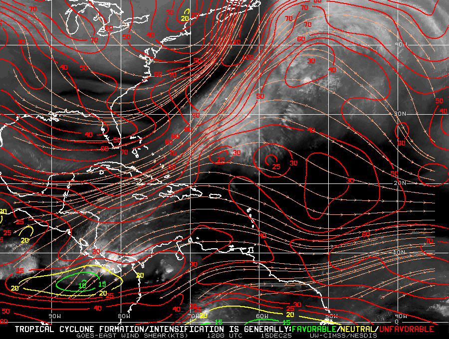
While the remnants of Dorian are producing more thunderstorms today than over the last 24 - 48 hours, it must still contend with a huge foe...strong upper level winds (shear) coming from the opposite direction.

The map to the right shows us where the shear can be found.

Right around the middle of the screen you'll find the small cloud area that is the remnant of Dorian.

Now focus on the orange lines starting over Florida, swooping down through Cuba into the Caribbean and then moving up just ahead of old Dorian. That is strong wind shear that should prevent it from growing again.

What to expect:

Puerto Rico: Will see on and off showers from the remnants of Dorian as the bulk of the moisture passes to the North.

Dominican Republic: Their weather office says the remnants will pass around 700 miles to the north, yet scattered storms may impact them tonight and tomorrow.

Haiti: As of this writing, their meteorological office is calling for a quiet weather pattern over the next 48 hours.

South Florida: This message comes from our local weather office.
AS FOR THE REMNANTS OF DORIAN...THE CONSENSUS AT THIS TIME CONTINUES

TO BE THAT THEY ARE LIKELY TO PASS TO OUR SOUTH AS A WAVE WEDNESDAY AND THURSDAY WITH NO SIGNIFICANT LOCAL IMPACTS ANTICIPATED AT THIS TIME BUT WILL CONTINUE TO MONITOR IN CASE THIS OUTLOOK CHANGES GOING
FORWARD.

Friday, July 26, 2013

T.S. Dorian, good news-bad news

The Good News:

Over the last 24 hours, dry air has played a key role in weakening the tropical storm.

It looks very disorganized, and it most definitively lacks that standard cyclone look.

The dry air slot in the atmosphere should remain in place another 24 hours or so further depriving Dorian of the moist environment it needs to survive and grow.

It is still moving west/northwest at a steady clip not giving it a chance to soak up any heat energy from the ocean.


The Bad News:

Dorian may fall apart altogether over the next 48 hours bringing to an end this chapter, but if it survives, it still has the islands in its path.

NHC still places Dorian near the Leewards by Mon-Tue, being pushed there by the Bermuda high.
All we can do is watch.

Thursday, July 25, 2013

T.S. Dorian

Tropical Storm Dorian formed from a Low in the Far Eastern Atlantic. It struggled a bit late Wednesday night, but it appears to have overcome that hiccup early Thursday morning.


It is still very far away from any land.
It is around 3000 miles away from Florida. At the moment it is spinning towards the Middle of the Atlantic Ocean, heading due west, being pushed along by the Bermuda High. It should stay like this until Sunday sometime when it takes more of a Northwest turn as the high retreats just a tad.


How strong will Dorian get?
This is still uncertain. It is scheduled to move over warmer waters that could fuel its growth, but its also going to run into some stronger wind shear. All we can do is watch and wait.


Wednesday, July 24, 2013

Tropical Depression Four

Very early on Wednesday morning, NHC started issuing advisories on an area of Low Pressure very far away from home, Its in the Eastern Atlantic, roughly 3500 miles away from South Florida.

Top winds are around 35 mph and it is moving West at 20 mph.

As of 5am, it has a well defined center with nominal thunderstorm activity.

It is being pushed west by a huge dome of high pressure.

So what lays ahead?

  • For the time being TD4 is moving over warm waters with very little shear and should have a chance to become Tropical Storm Dorian.
  • But in a couple of days, it will run into drier air and some shear that should keep the system in check,  
  • Intensity forecasting is not an exact science, but NHC keeps the system with 45 mph winds over the next 5 days. In a week or so it may be close to the Lesser Antilles.


Plenty of time to watch it.