Monday, May 12, 2014

If your grass needs water...

Better chance of rain from Wednesday through Friday.

It was a very nice and dry Mother's day weekend, but Mother Nature is asking for some rain here. Plenty of parched lawns and grass fires attest to that fact. It now seems we may get a good soaking by the middle to the end of this week.

I am looking at two areas that should impact South Florida in the days ahead.

  • Very, very out of season cold front
  • Patch of tropical rain

Lets begin with the front draped across the nation's mid section.

On the map you can see the blue line with small triangles attached, this is the leading edge of cold air.

This push of cold air flying South out of Canada, is making its way into the Mississippi River Valley, and running into warm moist air out of the Gulf of Mexico. This clash may lead to severe weather across Tornado Alley from Texas North through the Great Lakes.

This front is expected to get pushed Southeast by the jet stream and by Wednesday it should be somewhere across Florida's Panhandle. It will trap some moisture ahead of it giving us a better chance for rain.

The chance will increase through Friday when the front itself moves over South Florida.

Typically these fronts so out of season do not make it all the way here, but models are being very persistent so I'll keep a chance of rain through the end of the week.

Now lets look at the tropics for the area of clouds and rain.

This satellite picture is an enhanced infrared version. The darker greens, yellows and reds represent heavier rains.

The view is centered over Hispaniola. Cuba is to the left and South Florida in the Upper left corner.

This area of clouds and rain is by no means organized as you can see cloud movement in all directions.

For the moment its causing pesky rains for Puerto Rico, Haiti and the Dominican Republic.

Even though most of the heavy rain is moving northeast, there is some approaching the Southeastern Bahamas.

Models suggest this rain should be near the NW Bahamas and South Florida by Wednesday or Thursday. This added moisture could make a soggy scenario for us even wetter.

Sunday, May 11, 2014

Puerto Rico Rain

While our rainy season is on the verge of firing up, it is already underway throughout the islands.

Tropical moisture is moving in for our friends in Puerto Rico. The potential is there for heavy rain over the next few days.  Because of this, the Puerto Rico Weather Office has issued a flood advisory until Monday night.
* FLASH FLOOD WATCH FOR PORTIONS OF PUERTO RICO AND ALL OF THE
  U.S. VIRGIN ISLANDS...INCLUDING THE FOLLOWING AREAS...IN PUERTO
  RICO...CENTRAL INTERIOR...CULEBRA...EASTERN INTERIOR...
  NORTHEAST...PONCE AND VICINITY...SAN JUAN AND VICINITY...
  SOUTHEAST AND VIEQUES. IN VIRGIN ISLANDS...ST CROIX AND ST.
  THOMAS/ST. JOHN/ADJACENT ISLANDS.


This tropical moisture will continue to make its way West and eventually arrive in South Florida by midweek.

Short term:
Heavy rain possible for Puerto Rico

Mid Term:
Some pockets of heavy rain for Hispaniola by Monday and Tuesday.

Long Term:
Wednesday through Friday a chance for rain for South Florida.

I'll keep you posted


Thursday, April 17, 2014

Know your Zone

Final Day of 2014 Hurricane Conference

If there is one thing I can take away from this year's conference is that you should "Know your zone".

It basically means to be aware if you live in an evacuation zone. This is key to being storm ready.  Most evacuation orders are issued based on water threat alone. Wind is but a small part of the damage that can be caused by a hurricane.

Water is the number 1 killer during a storm, a far greater threat than wind or hurricane formed tornadoes.

Storm surge takes the highest toll on human life, followed closely by flooding from heavy rains.

The remaining threats are real, but they are not as severe as the water based dangers.

I thought I was ok where I live, miles away from the coast, until I was informed that storm surge can travel 40, 50, even 60 miles inland… this is why its so important to know your evacuation zone.

In our upcoming hurricane special we will have a complete report on all the evacuation zones in South Florida.

New this year, NHC will use what they call a "Graphical Tropical Outlook".

It will give us an idea of what areas may develop tropical activity up to 5 days out.

Even if there are multiple areas of concern over the Atlantic Basin, you will be able to view each individual area and see what may come of it.

DO NOT get confused by the highlighted areas. While they make look like the cone of concern, they are not.  They will just reflect the area where something may develop.  Its just an early detection system.

It sure was nice brain storming, sharing ideas, and concerns with colleagues from across town and the nation.  I learned plenty from the best at the National Hurricane Center. I thank Dr. Richard Knabb, director of NHC, and his great staff for helping us to keep you safe.

Left to Right: Yours truly, Roland Steadham, Max Mayfield, Brian Norcross, Rob Jone
Remember, even though it appears we may get a below average hurricane season… it only takes one. 1992 was a below average season and we got hit with Andrew.


Wednesday, April 16, 2014

Hurricane Conference Day 3

Do you know if you live in a flood zone? Do you know if you live in an evacuation zone?

Flooding and storm surge are the biggest threat to life and property.

In today's session of the National Hurricane conference, the message was loud and clear… know the answers to the above questions and have a plan of action.

It began with the Director of the National Hurricane Center, Dr. Richard Knabb emphasizing that while seasonal forecasts are a valid measure of storm activity, not one of them will tell you where and if a hurricane will make landfall. He stressed the rather quiet 1992 season when "Andrew" made landfall in what otherwise was a tranquil year. The bottom line is it only takes one.

He presented numbers that show how much work we as members of the media still need to do.

A recent survey says that today:

  • 54% of those questioned still believe taping windows is a good idea
  • 84% believe you should only evacuate based on wind speeds.   


Broadcast meteorologists need to do a better job communicating threats and actions to be taken when a threat arises.

Starting now, please if you think taping a window is a good idea, STOP. It does nothing to protect your property, you or your family. Only wood or other shutter-type materials will work.

As far as assessing the possibility of leaving your property based on wind... he is right. How many of us have heard the following, "I'll only leave if its a category three or above". The truth of the matter is water is just as destructive and deadly.  Look at Sandy when it struck the Northeast, it was barely a hurricane and the mess it caused and the lives it took could be compared to those of a stronger storm.

Which brings us back to leaving only when a "Major Hurricane" is threatening. What is major?  We know from the wind scale that would be a category 3 or above, but even lesser systems can be as damaging.  Dr. Knabb, other specialists, and myself urge you to prepare now and asses each storm as it approaches.

The Director of FEMA Craig Fugate, also drove home the point regarding long range outlooks.

 He says they should not be the main focus... that you should be ready no matter what.

He also added that Broward County has a great risk for high damage costs post a hurricane strike. Even more reason to make sure you are ready.

The 7Weather team and I, pledge to present all the threats that may accompany a system in order to help you better decide when to evacuate.

By the way our hurricane map and guide which will be available in just a few weeks absolutely FREE, will have what you need to know to find out if you are in an evacuation zone and where you can go to ride out a storm.


Tuesday, April 15, 2014

Hurricane Forecasting is a can of worms


Or day 2 of the National Hurricane conference in Orlando.

"Hurricane forecasting is a can of worms", that's how famed hurricane forecaster Dr William Gray opened his presentation.  He made this statement in front of a packed house. Every forecaster from the US and the Caribbean crammed into the small conference room to hear him, and his team, explain last years seasonal forecast debacle.

His team from Colorado State, which also includes Dr Phil Klotzbach, was very straight forward and humble explaining what happened.

Dr Gray said the brunt of the criticism came from fellow weather brethren, adding "... how brilliant meteorologists are after the fact".

Indeed he's right. Heaven knows I've blown my fair share of forecasts only 24 hours out...while he's dealing with a 6 month-long outlook.

But we're not here to throw stones, we're here to really learn about what happened.

 He explained that one learns more from failures,  adding  "because you have to go back and find out what happened". Good point.


So why did we have such a quiet 2013?
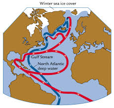
Blame it on the Atlantic thermohaline. An ocean current system to be precise, that helps to transport heat as well as cool waters across many areas of the Atlantic basin.

He said this conveyor belt of water suffered its biggest collapse since 1950. It happened rather quickly from winter to spring.

The collapse created cold air pockets and strong wind shear in the atmosphere making it more difficult for hurricanes to form. It also put in place a huge dome of high pressure that acted as a wall that storms could not penetrate.


Now what?

Dr. Gray is already predicting a quieter season, but why? The CSU team bases this on two key factors.

Once again he is pointing to the water conveyor belt in the Atlantic. He is suggesting it will have an impact, but a limited one.

This year he says Atlantic waters should run warmer which means more evaporation, which in turn makes the water more saline in the Northern Atlantic.  This heavier saltier water sinks causing further mixing. This greater mixing in the past has lead to more storms.


But wait!:

Dr. Phil Klotzbach chimes in with the other big signal for hurricane activity, that being El Niño.
He says west winds in the Pacific Ocean are pushing warmer water to the eastern Pacific signaling the start of El Niño.  Since February, ocean temps have been warming leading to what they suspect will be a moderate to strong El Niño event.  The last strong El Niño was in '97.

While this may lead to a less active season, according to Klotzbach, it has little impact on the Gulf States. They tend to see the average number of systems.  The team feels confident in their El Niño forecast giving it a 90% of development by late summer, while NOAA's projections are more subdued at 60%.

So the bottom line, even though the thermohaline hints at more activity, the overriding warming Pacific should keep everything quieter.


Climate Change:


Dr. Gray always says this is the "Big Gorilla" in the room. He says most media reports suggest the more CO2 in the atmosphere, the stronger and more active seasons will become.

He debunks all that suggesting there is no data that says CO2 from Global Warming equals more activity, as a matter of fact, he illustrates the opposite that more CO2 equals less activity.

I believe his time frame of only the last 100 years is too short. Who knows what will happen in the decades ahead if CO2 continues unchecked.


Director of National Hurricane Center
I also had the privilege today to interview one on one Dr. Richard Knabb, director of NHC. We talked about last season, this season, new developments for advisories this year, and climate change.

He truly is one the brightest and most level headed expert I know. We are in good hands at NHC.  I will have his full interview on our hurricane special to air before the start of the season.


By the way, speaking of hurricane directors, back in 1982 then director Neil Frank said, "there's no way to tell how active the Atlantic hurricane season is going to be." 

I believe no matter how advanced our forecasts get, there is some truth to that statement. I always prepare as if we will get hit, and never look back at numbers. I hope you will too.

Day 3 tomorrow.


Monday, April 14, 2014

National Hurricane Conference Day 1


There's nothing like a good 4 hour road trip to help you weed out all the stuff on your play list you no longer want to hear.

After an early start, fuel up, turnpike drive, midway stop for a snack/pit-stop, more turnpike driving… I finally arrived at my destination, the Orlando Hilton near SeaWorld.

Today I have caught up with old colleagues, emergency managers, and a few experts, in anticipation of what we may learn over the next few days.  

The buzz seems to be all about the forecast, or the lack of anticipated activity for the 2014 season. (But as you know, nothing is ever set in stone with Mother Nature).

I just finished lunch and its time to attend one of the many EMS sessions presented this afternoon. Its always good to hear, see, and get an appreciation of everything these professionals have to consider and go through when managing a hurricane threat. Who to evacuate, when, and at what cost. It almost makes hurricane forecasting seem easy.

Tuesday will be an early start, with a presentation by Colorado State University's Dr. William Gray and his assistant Dr.Philip Klotzbach and their assessment of how active 2014 might be. We already know they are calling for a below average season, but now we are going to find out why.

By mid-morning its off to a great historical session on Florida Hurricane's history reviewing such events as hurricane Charlie's west coast impact and the 10th anniversary of Florida's four hurricane strikes! Did we learn anything? More on that tomorrow.

There's also a brief one on one interview with the director of the hurricane center, Dr. Richard Knabb. I'm hoping to get his inside views on the upcoming season as well as a good explanation of all the changes NHC has coming this year.

The big presentation (at least for this weather enthusiast), will be the afternoon talk on advanced storm surge and hurricane forecasts. They'll touch base on Intensity Forecast Models, and my favorite… wait for it…. Knowing your Datums and Psurge! You'll need to wait for that one as well.

Will catch up again on Tuesday.


Thursday, April 10, 2014

Tropical Tune Up

Starting April 14th the hurricane conference gets underway in Orlando. Hurricane experts, forecasters, and broadcast meteorologists from all over the tropics will be in attendance.

We will be learning, talking storms, and hoping to get a better handle on what Mother Nature may bring our way for 2014.


The early bets are on a quieter season:

Some forecasts, as the one released by Colorado State University, suggest a below average year.

They are calling for 9 named systems, out of which 3 may become hurricanes, and of that number maybe one could reach category 3 status.

A typical year sees 12 named systems, 6 hurricanes, and 3 major hurricanes. These numbers are just a guideline, they will never be able to tell you where, when, and if a storm will strike...but are meant to help you get prepared for a season that lasts 6 months.

                                           It only takes one:
That's why I prepare every year as if we will get hit and I don't worry too much about numbers.

I spend one day getting all my supplies and then I am ready to go. I urge my parents, who are retired and on a fixed income, to start buying their supplies little by little over the previous months leading up to hurricane season, that way the cost will not be too overwhelming.

Whatever they don't use, they can consume after the season is done.


So why the early below average forecasts?:
Most experts suggest a phenomenon that happens in the Pacific Ocean will keep our season on the light side. It is called "El Niño" and its a warming of the equatorial waters. This warming not only disrupts marine currents but atmospheric ones as well, making it more difficult for hurricanes to grow in our neck of the woods.

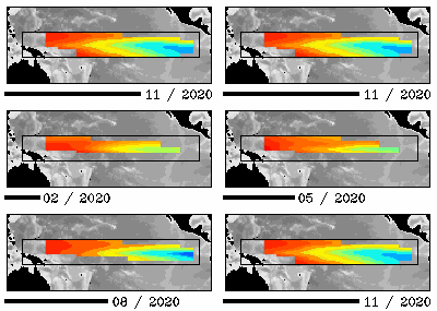
This animation shows the last 12 months of water temperature readings in the Equatorial Pacific. Experts say there is NO "El Niño" right now but notice the warm streak of water north of Australia growing and steadily expanding East. This could be an "El Niño" in the makings.

 NOAA says the odds of this event happening during hurricane season are better than 50% and better than 60% by the fall near the peak of activity for us in South Florida.

The graph illustrates how the models raise water temps starting around September and going even higher after that. The only problem is that these models do not show how strong it may be. If its a weak "El Niño", it may not have that much of an impact.


Computer models generally forecast sea surface temperature in the tropical Pacific to warm to levels over 0.5 degree C above normal this summer or fall, which would signal El Niño conditions (IRI/NOAA)

So is this "El Niño" a good thing fos us?
Typically when it comes to hurricanes yes, but its not certain. Hurricane Andrew struck South Florida in an El Niño" year and we all know how that turned out.

"El Niño" is just one of many ingredients we look at when trying to decipher the hurricane recipe. That's why I'll be attending the big Hurricane Conference Cookout next week in the hopes of figuring out what dishes Mother Nature will be serving this year. Look for my daily blogs starting on Monday.


Monday, April 7, 2014

Get ready for a Tetrad

A what you ask? 
When we get back to back, to back, to back, TOTAL lunar eclipses, the event is known as a Tetrad. NASA says the 21st century will host 9 sets of Tetrads, but don't think they happen too frequently, during the three hundred years between 1600 to 1900, there were no Tetrads! (The 20th century brought us 5, but I never saw any!!)


So now that we know these Tetrads are kind of a rare thing... when will they happen? 

Starting on April 15th, we will get to see 4 of them. They will take place just about every 6 months with the last one on September 2015. Typically we get to see a lunar eclipse twice a year, but not all are of the TOTAL variety.

A TOTAL Eclipse is the home run, the touchdown if you will of Lunar Events. As you know, A total eclipse happens when the earth blocks the sun's rays from reaching the moon, thus our shadow covers the moon. The whole process can last about 1 hour.

The upcoming TOTAL Eclipse will also be known as the "Blood Moon" because of its reddish appearance. You may also hear, much as we did with the Mayan apocalypse of 2012, that this marks the end of the world, well rest easy we are going to be fine.

Here is the explanation according to universetoday.com
"As the Moon enters into the dark umbra or core of the shadow of the Earth... the redness of the Moon is simply due to the scattering of sunlight through the Earth’s atmosphere. Incidentally, this redness can vary considerably due to the amount of dust, ash, and particulate aerosols aloft in the Earth’s atmosphere, resulting in anything from a bright cherry red eclipse during totality to an eclipsed Moon almost disappearing from view altogether… but it’s well understood by science and not at all supernatural."

Here is another explanation from NASA:
"A quick trip to the Moon provides the answer: Imagine yourself standing on a dusty lunar plain looking up at the sky. Overhead hangs Earth, nightside down, completely hiding the sun behind it. The eclipse is underway.
You might expect Earth seen in this way to be utterly dark, but it's not. The rim of the planet is on fire! As you scan your eye around Earth's circumference, you're seeing every sunrise and every sunset in the world, all of them, all at once. This incredible light beams into the heart of Earth's shadow, filling it with a coppery glow and transforming the Moon into a great red orb."


The neat thing about this Tetrad, is that according to NASA,  they will be visible from everywhere across the USA.  So when do they start?

Here is your timeline:
  • April 15, 2014
  • Oct. 8, 2014
  • April 4, 2015
  • Sept. 28 2015. 

NASA says, the first eclipse on the 15th will start at 2 AM Eastern time and lasting until 3 AM. If Mother Nature cooperates, it should be an easy eclipse to watch.


Tuesday, April 1, 2014

Tsunami warning

An earthquake has occurred of magnitude (Preliminary)8.0 
near the coast of northern Chile 

 
A Tsunami warning has been issued encompassing a large area. 
This according to NOAA: The Tsunami warning includes; 

CHILE / PERU / ECUADOR

While a Tsunami watch is in effect for:

COLOMBIA / PANAMA / COSTA RICA

This is the latest:
AN EARTHQUAKE HAS OCCURRED WITH THESE PRELIMINARY PARAMETERS

 ORIGIN TIME -  2347Z 01 APR 2014
 COORDINATES -  19.8 SOUTH   70.8 WEST
 DEPTH       -   10 KM
 LOCATION    -  NEAR THE COAST OF NORTHERN CHILE
 MAGNITUDE   -  8.0 
  
Authorities are not sure if indeed a Tsunami has been generated 
and the advisories are precautionary only.
 
The following is a great time frame as to when if any, Tsunami 
would impact the areas.
 
ESTIMATED INITIAL TSUNAMI WAVE ARRIVAL TIMES AT FORECAST POINTS
WITHIN THE WARNING AND WATCH AREAS ARE GIVEN BELOW. ACTUAL
ARRIVAL TIMES MAY DIFFER AND THE INITIAL WAVE MAY NOT BE THE
LARGEST. A TSUNAMI IS A SERIES OF WAVES AND THE TIME BETWEEN
SUCCESSIVE WAVES CAN BE FIVE MINUTES TO ONE HOUR.

 LOCATION         FORECAST POINT     COORDINATES     ARRIVAL TIME
 --------------------------------    ------------    ------------
 CHILE            IQUIQUE            20.2S 289.9E    0002Z 02 APR
                  ARICA              18.5S 289.7E    0011Z 02 APR
                  ANTOFAGASTA        23.3S 289.6E    0017Z 02 APR
                  CALDERA            27.1S 289.2E    0046Z 02 APR
                  COQUIMBO           29.9S 288.6E    0111Z 02 APR
                  VALPARAISO         33.0S 288.4E    0135Z 02 APR
                  TALCAHUANO         36.7S 286.9E    0219Z 02 APR
                  CORRAL             39.8S 286.5E    0251Z 02 APR
                  GOLFO_DE_PENAS     47.1S 285.1E    0403Z 02 APR
                  EASTER_ISLAND      27.1S 250.6E    0532Z 02 APR
                  PUERTO_MONTT       41.5S 287.0E    0546Z 02 APR
 PERU             MOLLENDO           17.1S 288.0E    0021Z 02 APR
                  SAN_JUAN           15.3S 284.8E    0039Z 02 APR
                  LA_PUNTA           12.1S 282.8E    0131Z 02 APR
                  TALARA              4.6S 278.5E    0218Z 02 APR
                  CHIMBOTE            9.0S 281.2E    0225Z 02 APR
                  PIMENTAL            6.9S 280.0E    0250Z 02 APR
 ECUADOR          LA_LIBERTAD         2.2S 278.8E    0239Z 02 APR
                  ESMERELDAS          1.2N 280.2E    0327Z 02 APR
                  BALTRA_ISLAND       0.5S 269.7E    0429Z 02 APR
 COLOMBIA         TUMACO              1.8N 281.1E    0346Z 02 APR
                  BAHIA_SOLANO        6.3N 282.6E    0417Z 02 APR
                  BUENAVENTURA        3.8N 282.8E    0433Z 02 APR
 PANAMA           PUERTO_PINA         7.4N 282.0E    0427Z 02 APR
                  PUNTA_MALA          7.5N 280.0E    0429Z 02 APR
                  PUNTA_BURICA        8.0N 277.1E    0441Z 02 APR
 COSTA RICA       CABO_MATAPALO       8.4N 276.7E    0441Z 02 APR
                  PUERTO_QUEPOS       9.4N 275.8E    0514Z 02 APR
                  CABO_SAN_ELENA     10.9N 274.0E    0531Z 02 APR 
 
Hawaii has also been added to the list under a Tsunami advisory. 

Friday, February 21, 2014

Viking Apocalypse

What?  The end of the world again? 

Yes if you're a Viking… that day is called "Ragnarok" and its happening this Saturday.

Ok, so this one is more mythical than anything else. The Vikings believed that one day there would be a final battle between the Gods and the humans, spelling the end of us all. My translation capabilities are not what they used to be so here goes….

These are the main protagonists:

  • "Surf", the fire giant
  • "Midgard" the Mighty Water Serpent
  • "Fenrir" the wolf (there's always a wolf in old tales!)
  • "Thor" of course we know from the movies…
  • and a host of other deities and giants

Act 1:
So hot footed "Surf" begins by setting all the land on fire.

Not to be outdone, "Midgard" begins to splash its tail sending huge tsunami-like waves everywhere.

Then "Fenrir" the wolf, who for some unknown reason is chained, breaks free and starts causing all sorts of havoc. It will eventually swallow the sun and moon and kill the God "Odin".


Act 2:
The ever popular and handsome "Thor" doesn't make it past the second act as he dies in battle along with "Midgard" the serpent.

Many more Gods die in a brutal bloody battle. Finally the only one left is "Surf" who celebrates by setting the rest of the planets on fire. (Way to go hot foot! By the way that's him in the picture above)

Act 3:
The God Odin makes a comeback (???) he tells us he can predict Ragnarock and avoid the end of the world.

He points to the signs leading up to this event, signs that can avoid the earth's destruction.


  • There will be a long winter lasting three years full of wars in which brothers will kill brothers
  • A beautiful red rooster by the name of "Fjalar" will warn the giants that Ragnarock is coming


Epilogue:
If the world does end, legend has it that a new one will rise from the water, beautiful and green. (Thank goodness)

Read more here: Extended version of the Viking End if the World


Tuesday, October 29, 2013

Why the time change?


We are all familiar with the saying, "spring forward, and fall back", which relates to setting the clock ahead one hour in spring and one back in the fall. But why do we do it? Here's a blog I wrote sometime ago explaining the tradition.


Here is a brief history of this practice:

18th Century:
Way back in the late 1700's Benjamin Franklin suggested that getting up earlier and enjoying the sunshine would help save lamp oil that would be wasted by staying up later at night.

19th Century:
When our country was young and most of the cargo was carried by train, companies needed set time zones so they would know where and when the goods would arrive. Time zones, splitting the nation into 4 parts, began in 1883. Until then, major cities set their own times from local astronomical observations.

20th Century:
By 1908, the House of Commons in England debated to change the time in order to eliminate "The Waste of Daylight". The measure failed.

Here in America, in 1918, congress passed a law making the time zones official for all to use but no time change was issued. That changed shortly thereafter as may countries engaged in World War I. The United States adopted Daylight Saving Time, pushing the clocks ahead one hour in order to conserve energy for the war effort. The measure was so unpopular that it was repealed as soon as the war was over.

As World War II emerged in 1944, we went back into Daylight Saving with clocks set ahead 1 hour. It remained this way until 1945. After the War, it was up to individual states whether to observe Daylight Saving.

By 1966 the Department of transportation was created and it took on the responsibility of handling the nation's time laws. They were confronted with a new problem... Television. How could networks tell the whole country at what time their favorite show would air if everyone was observing a different time zone? Over 100 million people were observing Daylight Saving set by local municipalities and customs, it was a mess.

Shortly thereafter, the Uniform Time act of 1966 was passed which called for the clocks to be set forward and backwards in the Spring and Fall. This new law just insisted that the states keep their times in a uniform fashion but did not force anyone to observe Daylight Saving.

21st Century
In 2007, new start and end dates were issued for Daylight Saving Time. It starts at 2 a.m. on the Second Sunday in March and lasts until 2 a.m.on the First Sunday of November.

As of last check, there are a few places that do NOT observe Daylight Saving. They are: Hawaii, American Samoa, Guam, Puerto Rico, the Virgin Islands, and by most of Arizona (with the exception of the Navajo Indian Reservation in Arizona).

Why do we still do it?
Proponents say, it saves energy.  We tend to use less electricity during the summer months because we are home fewer hours.  During this time of year, most Americans are enjoying outdoor activities. This means less electrical usage. According to the U.S. Department of Transportation, a poll suggested that Americans liked Daylight Saving Time because "there is more light in the evenings / can do more in the evenings."  They also add that while the amounts of electricity saved per household are small...added up they can be very large.

Thursday, October 3, 2013

Tropical Storm Karen

The low near the Yucatan Peninsula which caused all the rainy mess over South Florida on Wednesday, has become Tropical Storm Karen.


Where is it?
It appears the center has threaded the needle avoiding contact with land, making its way into the Gulf of Mexico between the Yucatan and Cuba.

This means its growth cycle will not be interrupted.

It is now moving into some of the warmest water in the Gulf of Mexico known as the Loop Current. This area just Northwest of Cuba and West of Florida is the birthplace of the Gulf Stream Current with temperatures hovering in the mid to upper 80's.  Plenty of fuel for further growth.

What next?


The models suggest it will take a track headed to Louisiana.


A HURRICANE WATCH IS IN EFFECT FROM GRAND ISLE LOUISIANA EASTWARD TO
INDIAN PASS FLORIDA. THIS DOES NOT INCLUDE METROPOLITAN NEW
ORLEANS...LAKE MAUREPAS...OR LAKE PONTCHARTRAIN

A TROPICAL STORM WATCH IS IN EFFECT FROM WEST OF GRAND ISLE TO
MORGAN CITY LOUISIANA...METROPOLITAN NEW ORLEANS...LAKE
MAUREPAS...AND LAKE PONTCHARTRAIN.


Even though they may see a direct impact, don't let your guard down. On Wednesday we were nowhere near this feature and yet some rain from it ventured here and cause plenty of flooding, Most areas from Downtown Miami South to Kendall and Pinecrest getting between 5 and 10 inches of rain.

This was issued by the Miami Weather Office: A RECORD RAINFALL OF 5.53 INCHES WAS SET AT MIAMI YESTERDAY. THIS BREAKS THE OLD RECORD OF 3.02 SET IN 1936.

Remain alert as more rain will be possible over the next few days and with the ground already saturated, any small amount of rain will lead to very fast street flooding.

Wednesday, October 2, 2013

Eyes on the Caribbean

I have been waiting a few days to post on the area of disturbed weather in the Western Caribbean Sea. I wanted to see if it would get its act together and if it would impact us in any way shape or form.

Well the time has come:
There is a broad low pressure swirl sitting due east of the Yucatan. Most of the weak cloud banding is to the east of the Low as well as much of the heavy rainfall.

NHC has deemed it INVEST 97L. This means its an area they would like to investigate a little further.

A recon plane is scheduled to check it out Wednesday afternoon.

What we know:
It will dump plenty of rain across the Cayman Islands, Western Cuba, and the Yucatan .

The radar out of Grand Cayman shows most of the heavy rain moving northwest from the islands and into the Yucatan.

The weather office in Grand Cayman says there may be some street flooding possible if the rain sticks around much longer.

The center should move into the Gulf of Mexico by Thursday.

Where is it headed?
Once in the Gulf, there is plenty of hot water that could provide the energy it needs to get stronger. By Friday it should run into the jet stream moving west to east. and it should get pushed anywhere between Louisiana to Northern Florida.


What can we expect?
We will stay away from any direct impacts, but plenty of surrounding moisture could get pushed our way.

Most of the rain is staying east of the center so if nothing changes, we should see some of it getting displaced here in the upcoming days.

Under this scenario there will be a chance for rain through Sunday, maybe into the early part of next week.

I'll keep you posted.