 Starting April 14th the hurricane conference gets underway in Orlando. Hurricane experts, forecasters, and broadcast meteorologists from all over the tropics will be in attendance.
We will be learning, talking storms, and hoping to get a better handle on what Mother Nature may bring our way for 2014.
The early bets are on a quieter season:
 Some forecasts, as the one released by Colorado State University, suggest a below average year.
They are calling for 9 named systems, out of which 3 may become hurricanes, and of that number maybe one could reach category 3 status.
A typical year sees 12 named systems, 6 hurricanes, and 3 major hurricanes. These numbers are just a guideline, they will never be able to tell you where, when, and if a storm will strike...but are meant to help you get prepared for a season that lasts 6 months.
It only takes one:
I spend one day getting all my supplies and then I am ready to go. I urge my parents, who are retired and on a fixed income, to start buying their supplies little by little over the previous months leading up to hurricane season, that way the cost will not be too overwhelming.
Whatever they don't use, they can consume after the season is done.
So why the early below average forecasts?:
Most experts suggest a phenomenon that happens in the Pacific Ocean will keep our season on the light side. It is called "El Niño" and its a warming of the equatorial waters. This warming not only disrupts marine currents but atmospheric ones as well, making it more difficult for hurricanes to grow in our neck of the woods.
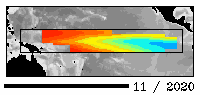 This animation shows the last 12 months of water temperature readings in the Equatorial Pacific. Experts say there is NO "El Niño" right now but notice the warm streak of water north of Australia growing and steadily expanding East. This could be an "El Niño" in the makings.
NOAA says the odds of this event happening during hurricane season are better than 50% and better than 60% by the fall near the peak of activity for us in South Florida.
The graph illustrates how the models raise water temps starting around September and going even higher after that. The only problem is that these models do not show how strong it may be. If its a weak "El Niño", it may not have that much of an impact.

So is this "El Niño" a good thing fos us?
Typically when it comes to hurricanes yes, but its not certain. Hurricane Andrew struck South Florida in an El Niño" year and we all know how that turned out.
"El Niño" is just one of many ingredients we look at when trying to decipher the hurricane recipe. That's why I'll be attending the big Hurricane Conference Cookout next week in the hopes of figuring out what dishes Mother Nature will be serving this year. Look for my daily blogs starting on Monday.
No comments:
Post a Comment