
We begin with Harvey.
Tropical Storm Harvey developed from T.D. 8. The biggest impact from this system will be the rain.

Most forecasts agree Harvey could drop anywhere between 3-5 inches and as much as 8 over high terrain. This should lead to flash floods, land and mudslides for Guatemala, Honduras, and Belize. Our thoughts are with them as we hope for the best. Below is the forecast cone regarding Harvey.

We now turn our attention to:
Wave number 1. It's the middle of the Atlantic Ocean with a better chance for growth. Up from a 20% chance on Thursday, to a 60% chance today. It will continue to move through an area of the atmosphere with favorable conditions for development... but the terrain ahead will be a tad hostile.

If it continues to get its act together, it may be a depression by the Lesser Antilles over the weekend. It may move over Hispaniola, and if it does, the high terrain there could have a negative impact on the system weakening it considerably. Unfortunately, it will dump plenty of rain over Dom. Republic and Haiti.

Wave number 2:
Has looked impressive on satellite ever since it emerged off the West Coast of Africa. From the very start NHC gave it a moderate chance for development and as of today that chance is high at 40%.
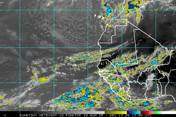
What's interesting to see from this picture is that there are at least two more "waves-to-be" right behind it over Central Africa.
This is where we look to this time of year for storm and hurricane formation. The good news, if there is any, is that we have plenty of time to watch them.

According to the models, this system should be a worry only for the shipping lanes.
It will find a weakness in the Bermuda high and steer away from the Lesser Antilles.
Unfortunately, it appears Bermuda may again be in the path of another storm down the road.
This feature is over one week away from them so they should have plenty of time to prepare.
Thanks Phil for keeping us informed. Have a great day!
ReplyDeleteThanks for reading. Keep checking in as we now have a new Tropical Storm.
ReplyDelete