- Weak cold front heading South.
- Area of disturbed weather sitting over the Yucatan Peninsula.

Lets start with the front. Satellite imagery shows clear skies from the plains out to the west coast. This is due to a push of cooler Canadian Air.
Ahead of the front, there is heat and humidity causing rain over the Great Lakes.
The leading edge of the front is expected to arrive here sometime Friday/Saturday. This will lead to a chance for showers on Saturday.
The front will then stall and slowly creep back up north on Sunday. Once this happens it will draw up tropical moisture which will lead to a better chance of rain for Sunday.
The second feature can be found on the lower right hand corner of the satellite picture. This is what's left of a Depression from the Eastern Pacific (old TD 12E). The remnants of this stretched out area of low pressure is presently causing plenty of rain over the region. NHC is giving it a 10% chance for growth.
Some models hint at the front tapping into this moisture on Sunday and if it does, it could mean a wetter Sunday. The chances of rain could stick around through the early part of the workweek as well.
A few models even hint at this disturbance turning into an area of low pressure and maybe even a tropical system in the days ahead. Climatology favors this area for tropical formation this time of year.
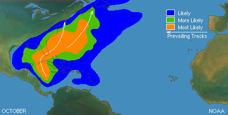
Usually during the month of October, if anything were to develop, it would do so in the NW Caribbean or Eastern Gulf of Mexico.
The typical path of anything forming here is toward Cuba and/or Florida.
We'll be watching this area of clouds and rain at WSVN over the next few days, just in case it decides to get its act together.
On a separate note, there is also another area NHC is following.

This is a surface low east of the Bahamas. It has plenty of rain, but as of Thursday night its chances for development have fallen from 30% to 20% . Models keep it along the favored track of most of the storms this year, along the Western Atlantic and then heading onto the Cold Waters of the Northern Atlantic and dying a quiet death in the long run.

No comments:
Post a Comment