Sunday, June 5, 2016

Tropical Storm Colin

As of 4:30 Sunday afternoon, what had been tropical depression three was upgraded to Tropical Storm "Colin". This makes it the earliest Tropical Storm on record to form in the Atlantic Basin.

As of 8pm, it had 40 mph winds, and was headed due North. But most of the rain is East and headed towards Cuba and Florida.


Here's the Latest Info:


  • Its moving North at around 10 miles per hour
  • As the loop shows, its not well organized as the western side is almost cloud free as upper winds interact with it.
  • Most of the heavy rain (Shown in the dark red colors) is aiming for Western Cuba and Florida.

Where is it headed?

The official cone from NHC suggests a possible landfall north of Tampa. The entire West Coast could get a huge soaking.

There is a flood advisory for SW Florida as they may get up to 5 inches of rain.

There is also the possibility of coastal flooding and erosion due to the strong surf. The strongest it may get, is 50mph and that's from going over the warm waters of the Gulf.

Its moving too fast for it to capitalize on that warmth.


South Florida impacts:
The Keys can expect rough surf, specially on the Gulf side, with gusty winds and some rain totals of up to 4" are possible.

Miami Dade and Broward:
Our main impact will be in the form of rain. If any of that big blob of rain continues to move NE, the rain should start to move in on Monday. The timing will be up to "Colin". There is a chance for some gusty winds and possible street flooding.  This soggy weather may stick around through midweek.


New tropical Depression 3 in Gulf

NHC is now issuing advisories on newly formed Tropical Depression Three. This is the latest :

The center of Tropical Depression Three
was located near latitude 21.9 North, longitude 88.1 West. The
depression is moving toward the north near 8 mph (13 km/h).  A
north-northeastward motion at a faster forward speed is expected
later today through Monday. On this track, the center of the
depression is forecast to approach the coast of the Florida Big Bend
area Monday afternoon.

Maximum sustained winds are near 35 mph (55 km/h) with higher gusts.
Some strengthening is forecast, and the depression is expected to
become a tropical storm before reaching the coast of Florida.

The estimated minimum central pressure is 1005 mb (29.68 inches).


As of this update:
  • The depression is accompanied by a large swath of showers and storms    
  • The winds have picked up to 35 mph
  • The pressure continues to drop which is a true tell-tale sign that the depression is intensifying and should become Tropical Storm "Colin" later Sunday evening.


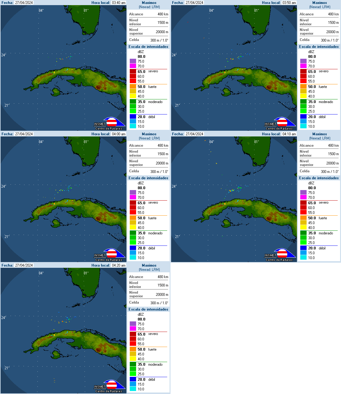
The radar out of Cuba:


Is detecting heavy rain moving North into the Florida Straits. These pockets of rain will stay on a Northerly track throughout Sunday with most of them staying over the SW Coastal waters.  

One or two of these batches of rain may stray east impacting our area throughout the day.

Winds should pick up out of the South.


Sunday Morning Models:

They insist on taking TD 3 near Florida's Big Bend Area. This keeps So FL away from the main strike, but the side impacts may be just as strong.

We will be on the NE side of the system , AKA the "Dirty Sector", and this will mean :

Locally heavy rain and flooding possible, specially for the Florida Keys, SW Florida and the Tri County area.


Official NHC Cone:
Keeps would be "Colin" near the Big Bend.


What to prepare for:
Please keep in mind our impacts will all depend on the exact track and speed of the storm. If it stays on the road the models are suggesting, then this is what we can expect.

NWS says: Our main worry will be in the form of heavy rain

  • We may see totals between 2 and 5  inches, with even higher totals by SW Florida. 
  • Strong Storms 
  • Windy at times
  • The possibility of tornadoes specially for Collier County Sunday night-Monday morning.
  • Broward and Miami-Dade may see a slight tornado risk by Monday afternoon.
  • They Keys: Will see t-storms with possible offshore winds around 40 mph at times. Expect some pockets of heavy rain.


Saturday, June 4, 2016

Storm in Gulf?

The area of clouds and rain in the Northwestern Caribbean Sea appears to be getting its act together this late Saturday . NHC says that surface observations show a broad area of low pressure forming. There are poorly organized thunderstorms starting to impact Cuba, mostly to the East of the alleged center.

The low will continue moving towards the Yucatan overnight, possibly moving into the Gulf of Mexico on Sunday.

This is when we expect the low to develop. NHC gives it a 80% chance that it could become a depression or a storm by then.

If it becomes a Storm it will be called, "Colin". We had "Bonnie" last month (and again this month) and "Alex" spun up in January.


Forecast track?

If it does develop, most of the models are indicating a path North of the Tampa area.

But these are preliminary runs. Since nothing has developed yet, there is no good starting point for the computers to use.

No good starting point means no good ending point. We should keep our eyes on this over the rest of the weekend.


What should we do?
For the time being, tune in from time to time and monitor the progress of this feature. This is a good reminder we are in hurricane season and you should be prepared for whatever Mother Nature sends our way.


  • Even if this low does not develop, we can expect possible heavy rainfall by the start of next week.  
  • Models are showing totals as high as 3-4 inches, with the higher totals by Collier County.  This may lead to localized street flooding, and even the potential for tornadoes.
  • A tornado worry may happen Sunday night for SW Florida and for the East Coast by Monday afternoon.  Make sure to have your notifications ON, on you favorite weather app. A weather radio is also a good idea to have.


Please be mindful all these possible impacts will depend on where exactly the system ends up.

A recon plane will go out on Sunday afternoon. Better idea by hen.


Friday, June 3, 2016

TS "Colin" by this weekend?

There is a good possibility we may have a tropical storm by the name of "Colin" in the Gulf of Mexico this weekend. If long range models are correct, the system could be near Tampa by the start of next week.

Lets catch up with the latest:
There is an area of disturbed weather in the Western Caribbean Sea that doesn't look like much right now, but models are being consistent that it will move into the Gulf by the weekend and organize.


The National Hurricane Center says there's a 70% chance that a depression or a storm could form in the area highlighted in red over the next 5 days.


The concern is, tropical systems need at least 80° of water temperature to grow and there's plenty of that in the Gulf.  Temps here are in the low to mid 80s. So there is enough fuel present to feed whatever develops.


If anything does develop it could track over the "Loop Current" which is one of the warmest spots in the Gulf and its also the birthplace of the Gulf Stream Current.


Models:
This area of concern has already been deemed Invest 93L (An area NHC would like to investigate further, the 3rd of the season in the Atlantic Basin) and very early computer model runs have been issued.  Take these with a grain of salt right now. Nothing has developed yet, and since there's no starting point, hence the ending points can be iffy.


Lets take a look at the European Model:
This one keeps whatever develops in the middle of the Gulf by Sunday with plenty of rain to the East that should start moving in here by Monday.


The GFS model:
Basically has the same set up with a little slower development. In this case the rain may move here later on Monday or Tuesday.


Hurricane Hunters:
A recon plane is on stand by for Saturday afternoon to investigate the area. This way the folks at NHC will get the crucial data they need to determine the possible development and track of this would be system.


The bottom line:
Regardless of formation, most models drag in a lot of moisture across South Florida by the start of next week. We could be dealing with heavy downpours, windy conditions, and even the possibility of isolated tornadoes.


This is the time to get prepared as hurricane season lasts through November and we've already seen plenty of activity in the Tropics.

Thursday, June 2, 2016

Possible Low in Gulf this weekend

Activity is picking up in the Tropics. "Bonnie" came back to life after almost falling apart completely earlier this week. It is now a depression off the eastern Seaboard. It will continue to move away out to sea and be a worry only for the shipping lanes.

Something to Watch:
Even though there's nothing in the Gulf right now, NHC thinks that over the next 5 days, there's a 40% chance that an area of low pressure may develop there.


A look at the models:
The latest run from the GFS and Euro models are picking this up and reflecting it in their forecasts . Remember, at this point they are giving us an educated guess. Since nothing has developed yet, there's no good starting point. No starting point means no ending point and thus no precise area as to where it may end up. But these are two decent models and they are both showing a possible area of low pressure near Central Florida. 

The GFS:
The GFS places the low offshore Tampa by Tuesday. Mostly heavy rain there, some downpours for us. 


The Euro:
Its delaying the arrival of the low, meaning more possible rain for us. Trailing moisture should swing up from the Caribbean and if its correct, it could mean flooding for South Florida.


A recon plane is on stand-by to check out this area of the Gulf on Saturday.


I want to stress that NOTHING has organized yet. This is a great time to make sure you are ready in case Mother Nature throws something our way. I'll be keeping you updated.

Wednesday, June 1, 2016

NHC looking at area in Gulf

Wednesday was the official start of hurricane season and with 2 systems under the belt already, we are looking at what may happen next.  NHC is eyeing the possibility of a low developing over the next 5 days in the Southeastern Gulf of Mexico. NOTHING has developed yet, but models are hinting at conditions being favorable for a "Low" to be stirring by the weekend.

NHC is giving this possibility, a 20% chance of actually developing over the next 5 days.

 
The GFS model shows what could be a real soggy mess for us with heavy rain by next Monday from Western Cuba through much of Florida.


This is worthy of watching because early in the hurricane season we focus on the NW Caribbean, the Gulf and the Coastal waters of  the Middle Atlantic States, as areas favorable for development.


 Even if nothing happens, it does appear we will see the possibility of breezy conditions and tropical downpours by the start of next week.  
 

Its been an active year thus far, even outside of hurricane season. We can already check off 2 names on the list for this season.


Tuesday, May 31, 2016

Tropical rain next week?

I want to mention the possibility of tropical downpours impacting South Florida by early next week.
For the time being, we'll settle into our typical rainy season pattern of plenty of heat, humidity, and afternoon storms through the weekend. By the upcoming Monday and Tuesday, models are hinting at more rain across the area coming up from the Caribbean and Central America.  

Forecast models:


The GFS shows that by Monday, and area of low pressure develops bringing heavy rain with it.

As of the latest run, most of the big downpours remain offshore, but still with rain from I-75 and Tamiami Trail South.


By Tuesday, it appears the rain sticks around for at least another 24 hours. The unsettled weather should improve by late midweek.

The European model also calls for the rain, but instead of keeping it offshore it draws it more over us.

We'll be monitoring over the next few days.


Friday, May 27, 2016

Hurricane Season 2016 Forecast

Its that time of year when Floridians are on-guard hoping to avoid a direct hit from the world's strongest storm...a hurricane. The season runs from the first of June through the end of November, but this is a man-made time frame, hurricanes can happen at anytime. 


As a matter of fact, we are already tracking Tropical Depression #2 which is aiming for the Carolinas. NHC thinks it could become TS Bonnie over the next 24 hours. We we've already seen a hurricane this year, in the month of January by the name of "Alex". The last time a hurricane developed this early was January of 1938.

"Alex", was born on January 13th as a Sub-Tropical Storm in the middle of the Atlantic and by the following morning it reached hurricane status.

It threatened the Azores in the far Eastern Atlantic but it eventually fell apart on Friday January 15th.

The main ingredient for hurricane formation is hot sea surface water, on average 80 degrees and above. Anything lower and there is not enough fuel for systems to develop. This is why hurricane season spans the months of June through November when you get the warmest waters in the Atlantic basin.


Seasonal Forecasts:
The hurricane center is calling for 10 to 16 named systems, out of which 4 to 8 could become hurricanes, and out of that number, maybe 1 to 4 can reach Major Hurricane status (category 3 or above). If you compare to what is average, it appears we may see a typical season. What these projections can't tell you is where a hurricane may strike, or how strong it may be. Plan as if we will get hit, and you will be prepared for anything Mother Nature throws our way.


The Colorado State University outlook
(The last issued by the combo of  Philip Klotzbach and Dr. William Gray. Dr. Gray passed last month at age 86. He was a pioneer in long range forecasting.) The forecast calls for, 12 named systems, out of which, 5 could be hurricanes, and out of this number, 2 may reach Major Status with winds of over 111mph.


Key Factors to watch for:
Sea Surface temps: Models are not in fair agreement as to how hot the Atlantic Ocean may be in 2016. Some suggest a pool of cold water in the Northern Atlantic (highlighted in blue South of  Greenland) dipping South inhibiting or at least slowing down hurricane formation.

Others, like the North American Multi-Model Ensemble shown here, illustrates very warm waters all along the East Coast, Florida, and even in the Gulf of Mexico for the months of August, September, and October.

This warm water scenario could in turn make for a more active season.


El Niño / La Niña: This phenomenon will also be a key player in 2016. We've had one of the strongest "El Niño" event on record since last season.

As you know, "El Niño", is a warming of the Equatorial Waters of the Pacific Ocean. It not only disrupts marine currents, but atmospheric ones as well.

It also causes strong upper level winds that move from the Pacific into the Caribbean and Atlantic cutting down the tops of developing systems. It usually means a quieter season.


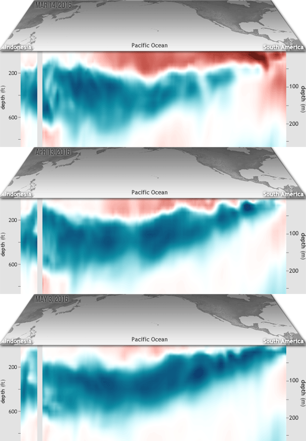
But "El Niño" is weakening and expected to cool down below average by late summer/early fall turning it into "La Niña"

"La Niña is a cooling of the Pacific waters and it tends to weaken that upper air shear that keeps systems in check. In turn we tend to see more activity during "La Niña" years. Add this to possibly warmer water temps and it may turn out to be an active year. All we can do is watch and wait.


You can see in this animation how the Pacific waters are already transitioning from warm to cold. This could lead to more activity later in the season. It is something worth watching.

But why the seasonal forecasts?
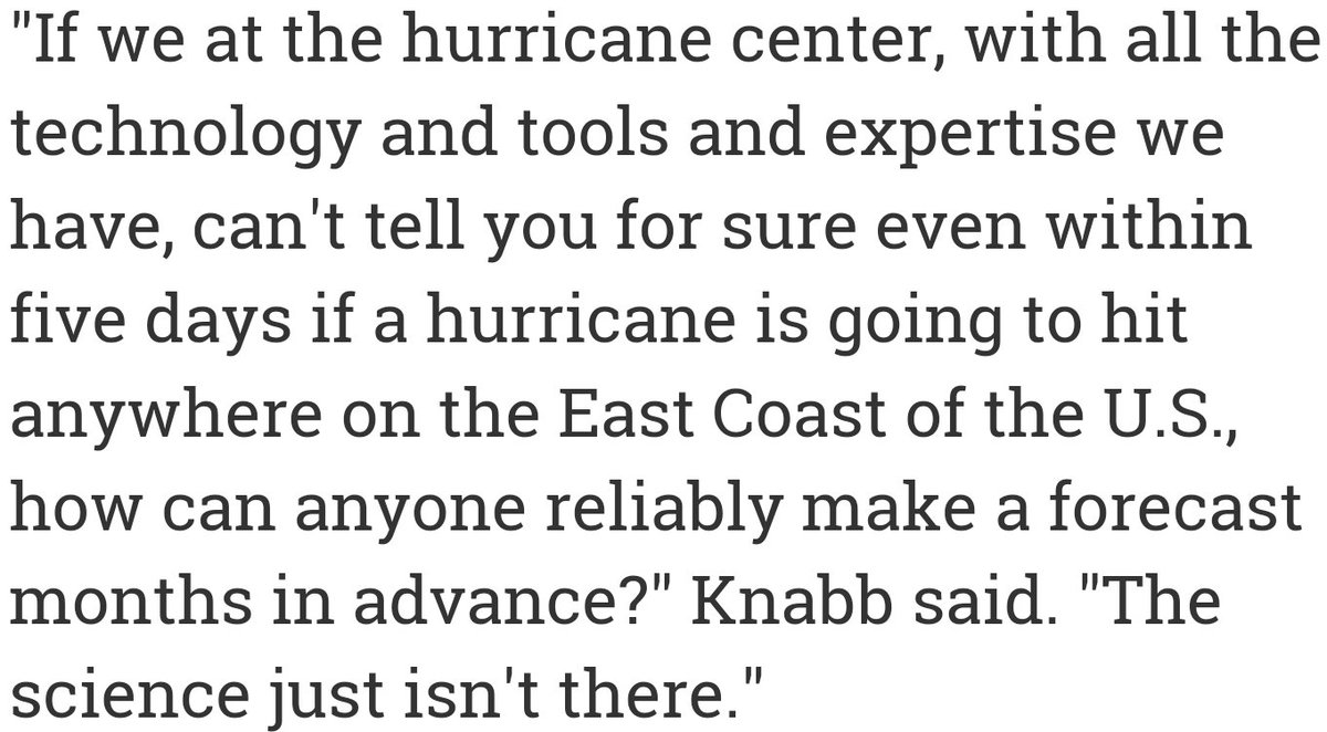
Check out what Dr. Richard Knabb, the director of the hurricane center had to say recently regarding long seasonal outlooks.


Here lays the problem. We all want to alert you and let you know how active a season may be. But are we doing a disservice?  If the forecasts are low, do you prepare less and let your guard down? More preps if season is to be active?

Why don't we all just prepare accordingly and be ready for whatever Mother Nature throws our way? It is going to take plenty soul searching from the Media, NHC, insurance companies, and you to figure out how we proceed in the long run. Seasonal outlooks or none.

But we must prepare just in case:
  • If an earthquake were to happen right now, I could not give you any warning. 
  • A tornado? A few minutes heads up could be a lifesaver. 
  • A Hurricane?: Unlike the above mentioned events, you will never be taken by surprise. You will get bored of seeing all of us weather people alerting you ad nauseum, sometimes up to a week out.  So you can prepare. Now is the time to review your hurricane plan.

The most important thing to do is to make sure your property is protected. Shutters or wood panels are all good to protect your windows and doors. If you have impact resistant windows, be aware, it doesn't mean proof. While they may resist a direct projectile impact, they may shatter on the inside and if you are standing right by it, you could get hurt.

If you live in an area prone to flooding or near a body of water, make sure you are ready to evacuate when told to do so. Make those arrangements now.

For a complete list on preparedness info, check out our on-line hurricane map and guide:
Link to WSVN's Hurricane Map and guide. Click here

Also, don't do it all at once. Buy a couple of water bottles here and there, some extra canned foods, a flashlight with batteries now, maybe a solar phone charger down the road. The trick is to do it within your means and way before a system threatens.


Tuesday, May 24, 2016

Hurricane Center watching the Bahamas

As of  3:30pm Tuesday, NHC is watching an area by the Bahamas for possible development. There is an area of clouds and rain that extends from the Florida Straits, NE into the Western Atlantic. This is part of a front that has brought us the storms over the last few days.

Officially Hurricane Season kicks off on Saturday , June 1st, but this is a man-made time frame.

Storms can happen at any time as long as there is plenty of fuel in the form of hot water, 80 degrees or above.


Water temps:
Right now most of the Caribbean is registering sea surface temps in the low to mid 80s, with an area between Cuba and the Bahamas in the mid to upper 80s.

There is enough energy to sustain whatever develops. This is one of the main reasons why NHC is issuing this Formation Potential update.

 January Hurricane 

If you recall, we already had a hurricane in January in the Atlantic by the name of Alex. .

Alex was the first hurricane to form in January since Alice in 1955 and also the first to form in the month of January since 1938. 

It originated as an extratropical cyclone near the Bahamas on January 7, 2016. The system initially traveled northeast, passing Bermuda on January 8, before turning southeast.

It eventually got stronger and reached hurricane-force winds by January 10.


Nothing has Developed Yet!

NHC keeps the chances of something developing at zero over the next 48 hours. The chances go up to 30% over 5 days. If anything were to develop, it would do so in the area highlighted in yellow.


What are the models saying?:


The European:
This model keeps the feature as a tropical wave or a disturbance through the weekend, with plenty of rain for the SE Bahamas and Eastern Cuba.

If this model pans out, there is a possibility places like Haiti, Dominican Republic, the Central Bahamas, and Eastern Cuba could see some flooding from total rain accumulations.

The GFS model:
It suggests a possible area of low pressure near Georgia come Sunday night into Monday, Memorial Day.

In this outcome, coastal rain is a possibility across the Carolinas and as far inland as West Virginia.


Our In-House model:
It keeps the area of clouds and rain, as just that, with most of the downpours staying offshore by Saturday afternoon.

With these model variations, we have narrowed it down to 2 possible scenarios. Everything will depend on high pressure sitting over the Western Atlantic.

Scenarios

Scenario Number 1:
Will keep the area of disturbed weather over the Bahamas, drawing in rain that should eventually reach South Florida by the Holiday Weekend.


Scenario Number 2:
Has the high weakening and moving East, opening the door for whatever develops to head for the Southeast or even the Middle Atlantic States.


Bottom Line:
Nothing has developed yet. I repeat, nothing has popped up. NHC is issuing formation chances as a precautionary measure. All we can do right now is watch and wait. This is a good reminder that hurricane season starts on June 1st and you should be ready.  WSVN will air our hurricane preparedness special entitled, "Surviving a Storm" Friday at 8 pm.

Monday, May 23, 2016

Tropical Activity Early Next Week?

Many of you have texted/e-mailed me regarding the possible development of an area of low pressure next to Florida by early next week.  It seems that the weather channel has been making a big deal of this.

They say:
"SOME computer models are HINTING at the development of a weak surface low off the Southeast coast or in the eastern Gulf.  This possible low could gradually acquire either subtropical or tropical characteristics and become a depression or named storm."

There are plenty of coulds and possibles regarding this low.  So lets take a look at what is happening and what may happen.

The Big View:
The satellite imagery covering the entire Atlantic Basin is quiet. Clouds by Cuba are related to a weak front moving East, away from us. Skies are clear over the Gulf, most of the Caribbean and Atlantic Ocean. It is hard to foresee anything developing over the next 5 days. But stranger things have happened.


The GFS model is suggesting an area of low pressure north of the Bahamas in around 102 hours. In this scenario, most of the rain is to the north of the low.


The CMC or Canadian Model is also looking at an area of low pressure right around the same spot but in about 5 days.


What these models can't tell us, is how strong any of this may be. It is just a projection. This may just be an area of clouds and rain, or as the Weather Channel is hinting, it could be something stronger. Based on the sea surface temperatures which are already above 80 degrees in many areas, there is enough energy for something to form. Its just too early to tell.

Bottom Line:
One should never reach a conclusion based on a handful of models. Nothing has developed yet so there is no clear starting point. If there is no clear starting point, the ending point is also an educated guess. The National Hurricane Center has not issued anything related to this. When and if they do, then we'll have something to follow and forecast.

For the time being:
Hurricane season begins June 1st. Regardless of development offshore, you should be ready for whatever Mother Nature throws our way. Get ready now and you'll avoid the crowds and the headaches down the road.  By the way, WSVN will air a preparedness special entitled "Surviving a Storm" Friday May 27th at 8 pm.


Thursday, May 12, 2016

True North is Slipping

The magnetic North Pole drifts just under 25 miles every year. It also varies in intensity. A new report by the European Space Agency suggests it may be moving faster and also weakening.

  • The magnetic field is very important to our health. It blocks harmful radiation, solar storms and cosmic rays.
  • Scientist have known for awhile that the global magnetic field has weakened, 10% since the 19th century.

The new report shows our protector is weakening.
The map shows in blue where the field is weak, and in red where its strong.


According to Spaceweather.com :
The European Space Agency's report indicates that the field has weakened by about 3.5% at high latitudes over North America, while it has strengthened about 2% over Asia. The region where the field is at its weakest – the South Atlantic Anomaly – has moved steadily westward and weakened further by about 2%. These changes have occurred over the relatively brief period between 1999 and mid-2016.

With less protection, more radiation can filter through the atmosphere causing a higher danger for skin burns.

Magnetic Field History:
These changes have occurred in the past with a greater impact. At times it will flip completely with the Magnetic North heading South and vise versa. Its an unpredictable event, but it appears to take place roughly every 300 thousand years with the last switch taking place almost 800 thousand years ago.
Scientist have prove of these reversals etched in the magnetism of ancient rocks.

Will we see a huge flip soon?  All we can do is watch and wait.