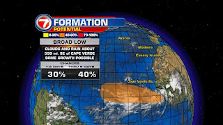
In all seriousness, there is a broad area of low pressure just off the West Coast of Africa with a chance to develop into a depression or a Tropical Storm.
This area of clouds and rain is centered just over 500 miles SE of the Cape Verde Islands, moving at around 15 miles per hour to the west/northwest.
According to NHC, it has a medium chance for growth over 5 days.
It is part of a long line of clouds extending from the Eastern Atlantic, all the way inland through Mainland Africa.
Working for it:
Little wind shear presently over that area, plus warm waters ahead.
This should be enough to give it a chance to develop, but it should do it soon because that window of opportunity may close rather quickly.
Tropical Systems need sea surface temperatures of at least 80°, in order to grow. This heat provides the fuel for tropical engines to intensify. The hotter the water, the more energy to work with. At present, water temps will only get warmer as it treks across the Atlantic.
 Where is it headed?
As of this update, this area of clouds and rain has been dubbed Invest 96.
This is now an area NHC will INVEST more time to determine where it may go.
Very early model runs suggest it will stay far away being a nuisance only to the shipping lanes.
Even if it develops, it should stay over open waters.
Working against it?
 The lines on the map show strong upper level winds on the road ahead. These winds may act as a knife cutting down the cloud tops of this feature as it tries to grow.
So it has to develop quickly if it wants to survive.
This disturbance in the Far Eastern Atlantic may be signaling the start of "Cape Verde" season. A season within a season, if you will, of increased tropical activity.
This Mini season usually runs from August through September. It gets the name from the fact that most waves and disturbances tend to spin off the West Coast of Africa and pass near the Cape Verde Islands.
Once these disturbances emerge into the Atlantic, they have a huge ocean ahead full of warm water and the chance for intensification.
And if we look at the satellite imagery over Africa, it seems that disturbances are lining up ready to head west and move offshore.
The good news is that since they are so far away, it gives us plenty of time to watch, analyze, and provide a better track forecast.


excellent blog... covered all the bases with originality
ReplyDeleteThanks
ReplyDelete