Thursday, July 28, 2016

Two Waves to Watch

NHC is watching two waves in the Eastern Atlantic. They are trying to get their acts together as they move west across the ocean pushed along by the Bermuda high.We've been following the one closest to the West Coast of Africa since Wednesday.  This wave also has an area of low pressure near the surface located around 300 miles SSE of the Cape Verde Islands.


It has a 40% chance for development over 5 days in the area highlighted in orange. 


Keep in mind this is not a forecast track, but it is the area NHC thinks it has a chance to become a depression or a storm.
 
The newest wave is the one highlighted with the yellow "X". 
 

It's sitting right smack in the middle between Africa and the Lesser Antilles, moving rather quickly west at almost 30 mph.

Development is being kept low because of that speed, but it could still drop some rain over the islands by the weekend. Again the yellow swath is not a track but where it may organize and grow stronger.


Both of the waves have a huge road block ahead of them in the form of strong upper level winds.

They are being caused by a combination of an Upper High in the Atlantic and an Upper Low north of Puerto Rico.

This combo could end up being fatal to the waves, as the strong upper winds converging east of the Lesser Antilles can shear them apart.

All we can do is wait and see what happens.

Upper Low could be a Rainmaker:
The low near Puerto Rico has plenty of moisture with it and it is moving west.  If it does not fall apart, this is what we can expect.


By Friday:
The rain should start moving into Hispaniola and SE Bahamas with fresh winds out of the East. It could cause a few issues for boaters.


Saturday:
The rain shifts to the Central Bahamas. If the wave in the Mid Atlantic survives the shear, it should be near the Islands. It may provide for some rain.


Sunday:
The Upper Low shifts over South Florida pushing moisture our way which could lead to a chance for pockets of rain. The wave should be aiming for Cuba.


Long range outlook:
If the wave persists, we may be some tropical downpours here by the middle of next week.

Wednesday, July 27, 2016

In the Atlantic Far, Far, Away...

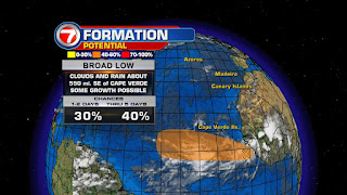
The hurricane Jedi's have kept this season very quiet thus far, but there is a rumbling in the force. A disturbance in the Far Eastern Atlantic has popped up, and the folks at NHC have taken notice.

In all seriousness, there is a broad area of low pressure just off the West Coast of Africa with a chance to develop into a depression or a Tropical Storm.

This area of clouds and rain is centered just over 500 miles SE of the Cape Verde Islands, moving at around 15 miles per hour to the west/northwest.

According to NHC, it has a medium chance for growth over 5 days.

It is part of a long line of clouds extending from the Eastern Atlantic, all the way inland through Mainland Africa.


Working for it:
Little wind shear presently over that area, plus warm waters ahead.

This should be enough to give it a chance to develop, but it should do it soon because that window of opportunity may close rather quickly.

Tropical Systems need sea surface temperatures of at least 80°, in order to grow. This heat provides the fuel for tropical engines to intensify. The hotter the water, the more energy to work with. At present, water temps will only get warmer as it treks across the Atlantic.


Where is it headed?
As of  this update, this area of clouds and rain has been dubbed Invest 96.

This is now an area NHC will INVEST more time to determine where it may go.

Very early model runs suggest it will stay far away being a nuisance only to the shipping lanes.

Even if it develops, it should stay over open waters.


Working against it?
The lines on the map show strong upper level winds on the road ahead. These winds may act as a knife cutting down the cloud tops of this feature as it tries to grow.

So it has to develop quickly if it wants to survive.

This disturbance in the Far Eastern Atlantic may be signaling the start of "Cape Verde" season. A season within a season, if you will, of increased tropical activity.

This Mini season usually runs from August through September. It gets the name from the fact that most waves and disturbances tend to spin off the West Coast of Africa and pass near the Cape Verde Islands.


Once these disturbances emerge into the Atlantic, they have a huge ocean ahead full of warm water and the chance for intensification.

And if we look at the satellite imagery over Africa, it seems that disturbances are lining up ready to head west and move offshore.

The good news is that since they are so far away, it gives us plenty of time to watch, analyze, and provide a better track forecast.


Monday, July 18, 2016

A Florida Earthquake?

Many have asked me about the validity of a report saying Florida felt an earthquake this weekend.
Well, felt may be a stretch, but it is true, a weak tremor was registered offshore.

On Saturday July 16th, a small underwater quake was registered about 100 miles just off Florida's East Coast.

Late Monday night, the United States Geological Service (USGS), which tracks earthquakes, says the tremor was a NAVY test. They confirmed it on their site only saying it was experimental. That was it. You can check their official site:   http://earthquake.usgs.gov/earthquakes/eventpage/us20006f8n#executive

It still leaves many questions, the least of which, is it safe to go boating through the area?  Fortunately, the tremor caused by the explosion was too weak to be felt on land.


Over the last 200 years there have been a handful of tremors that shook the Sunshine State. Not a lot compared to other areas of the world, but that is a mere blink in geological time.

Here's a quick look at Florida's quake history:
(Courtesy of USGS)
  • A shock occurred near St. Augustine, in the northeast part of the State, in January 1879.The Nation's oldest permanent settlement, founded by Spain in 1565, reported that heavy shaking knocked plaster from walls and articles from shelves. Similar effects were noted at Daytona Beach, Tampa, and as far north as Savannah, Georgia.
  • In January 1880, Cuba was the center of two strong earthquakes that sent severe shock waves through the town of Key West, Florida.
  • On June 20, 1893, Jacksonville experienced another slight shock, apparently local, that lasted about 10 seconds. 
  • Another minor earthquake shook Jacksonville at 11:15 a.m., October 31, 1900. It caused no damage.
  • A sudden jar caused doors and windows to rattle at Captiva in November 1948.
  • On November 18, 1952, a slight tremor was felt by many at Quincy, a small town about 20 miles northwest of Tallahassee.
  • Three Florida shocks of doubtful seismic origin rumbled through the Everglades - La Belle - Fort Myers area in July 1930, Tampa in December 1940, and the Miami - Everglades - Fort Myers area in January 1942. Most authorities attribute these incidents to blasting, but a few contend they were seismic. 

Friday, July 15, 2016

Weekend Weather


The weekend is here and we will be right in the middle of a tug-of-war between 2 air masses. We are stuck between one air mass loaded with moisture and the other with dry air. The first image shows us all the cloud cover across Cuba and the Florida Straits.

There is an area of low pressure in the upper levels of the atmosphere right over Cuba, along with high pressure over the Atlantic Ocean.

These will be the two main players in our weekend out look.
 
The Upper Low is dragging plenty of moisture from the Caribbean and causing plenty of rain over Cuba.

We had some downpours by the Keys along with heavy downpours Friday night with plenty of lightning over Miami-Dade and Broward .

Over the Atlantic, there is dry air trying to make its way across South Florida as well. The question is, "Who will win the battle?'

 The models are suggesting, the Upper Low will move into the Eastern Gulf of Mexico over the weekend, with the high staying more or less put in the Atlantic. For us this means a few morning showers along the East Coast, with heavy downpours across the Everglades and SW Florida in the afternoons.

 
It will also be hot with the heat index hovering around 105° both Saturday and Sunday. Please drink plenty of water and do not leave pets or children in locked cars.

Thursday, July 14, 2016

Where's La Niña?

Earlier this year before the start of hurricane season, most outlooks were taking into account the death of El Niño and the birth of La Niña. This would mean more favorable conditions for tropical systems to grow.  But with a steady plume of Saharan Dust dominating the Atlantic Ocean, systems have been scarce, and that's fine with us.

So where are we now?
The color enhanced satellite image shows that most of the Equator across the Pacific is white to blue.

This suggests that water temps are near typical values or just slightly cooler.

Waters to the north and south of the Equator are running a little warmer but this is normal as well.


In June NOAA reported:
"After dominating the tropical Pacific for more than a year, El Niño ended in May 2016. Near- or below-average temperatures existed in 3 out of 4  (El Niño Southern Oscillation or ENSO for short) monitoring regions of the tropical Pacific. And for the first time in 2016, wind and air pressure patterns were consistent with neutral conditions. There's a 75% chance that La Niña will develop by winter."

What's the latest on La Niña?
As of July 14th, NOAA seems to think if it does develop it may be a weaker event. They add:


"Compared to last month, models have slightly backed off their confidence—from 75% to 55-60%—that La Niña will occur this fall and winter. While tropical Pacific waters have cooled, the trade winds have not showed the La-Niña-like strengthening needed to amplify cold-water upwelling. The current outlook favors a weak event, but remember: impacts aren't always tied to event strength."
 
What does this mean for the rest of hurricane season?
If indeed we get a weak La Niña, then we may not see increased activity. Add to that, so much Saharan Dust in the atmosphere, and storms may not be as frequent for the rest of the season. The fly in the ointment to all this will be the arrival of Cape Verde season which typically kicks off in August. Here we keep our eyes on the West Coast of Africa as more tropical waves tend to start their cross Atlantic voyage and aim for the Caribbean and US East Coast.

Also, the peak of hurricane season is mid September, when we usually see the most tropical activity. We may still get a few storms and a hurricane or two in the Atlantic basin, but with a weaker La Niña expected, this should NOT provide any additional fuel for more storms to develop. Lets hope this is the case.

Here's a little background on El Niño and La Niña.

What is El Niño?
This is a WARMING of the Equatorial waters of the Pacific. It not only impacts marine currents but atmospheric ones as well. It kind of shakes up the planet turning mostly dry areas into soggy ones and wet ones into drier ones. It also keeps hurricane formation at bay.

What is La Niña?
This is a COOLING of the Equatorial waters of the Pacific. Here too, it impacts both marine and atmospheric currents. In this case, it makes wind patterns in the Atlantic more favorable for storm formation.

Thursday, July 7, 2016

Super Typhoon Nepartak

UPDATE: Just getting first view of Nepartak's aftermath in Taiwan.


One of the strongest storms so far this year by the name of Nepartak, struck Taiwan on Thursday with whipping winds, blinding rain, and storm surge. Nepartak translates to "warrior" in the local Micronesian language, and it is truly waging war, going ashore with category four winds of up to 150 mph and gusts topping 185 mph.


This satellite image shows how well organized the system is with symmetrical banding and a small and compact eye. 

Even areas far from the center will feel its wrath over the next 24 hours until its interaction with land starts to weaken it.

The eye of this Super Typhoon dropped 4-9 inches of rain, with hourly rates reaching from 1 to 3 inches in parts of central and southern Taiwan. 

Nepartak is being considered the strongest landfall in almost half a century.

Color enhanced infrared imagery, gives us an idea as to where the heaviest rain can be found. The dark red region is where the torrential downpours are coming down. 

The thin white circle around the eye is the "eye wall", where you can find the strongest winds.This is a ring of destruction capable of incredible damage wherever it goes.

Typhoon warnings remain in place for the time being, across the mountains, central Taiwan as well as the coast.

In the Western Pacific, hurricanes are known as Typhoons, and major hurricanes are called Super Typhoons

Super Typhoon Nepartak

One of the strongest storms so far this year by the name of Nepartak, struck Taiwan on Thursday with whipping winds, blinding rain, and storm surge. Nepartak translates to "warrior" in the local Micronesian language, and it is truly waging war, going ashore with category four winds of up to 150 mph and gusts topping 185 mph.

This satellite image shows how well organized the system is with symmetrical banding and a small and compact eye. 

Even areas far from the center will feel its wrath over the next 24 hours until its interaction with land starts to weaken it.

The eye of this Super Typhoon dropped ,early estimates, of 4-9 inches of rain, with hourly rates reaching from 1 to 3 inches in parts of central and southern Taiwan. 

Nepartak is being considered the strongest landfall in almost half a century.

Color enhanced infrared imagery, gives us an idea as to where the heaviest rain can be found. The dark red region is where the torrential downpours are coming down. 

The thin white circle around the eye is the "eye wall", where you can find the strongest winds.This is a ring of destruction capable of incredible damage wherever it goes.

Typhoon warnings remain in place for the time being, across the mountains, central Taiwan as well as the coast.

In the Western Pacific, hurricanes are known as Typhoons, and major hurricanes are called Super Typhoons

Tuesday, July 5, 2016

Saharan Dust both good and bad

Why is this haze good at keeping hurricanes at bay, but bad for your health?

As you noticed on Tuesday, our skies had a milky look to them. This is because sand from the Saharan desert has made it all the way into South Florida.

This happens when huge storms whip up the sand in the Sahara, sending it upwards into the upper levels of the atmosphere where it is pushed our way by strong upper level winds.  This dust cloud can be detected on special satellite imagery. You can see the huge plume of orange and yellow coming off Africa and heading West. 
 
 
The good:
This cloud of dust keeps the atmosphere across the Atlantic mostly dry not allowing any storms to form that could develop into hurricanes.

The bad:
The dust is an irritant and can worsen the condition of people who suffer from respiratory issues. Try to remain indoors if you can, in air-conditioned dwellings.
The dust will keep us dry for the next few days preventing any cooling rain showers to develop, so expect the stifling heat to continue.