The center of Tropical Depression Three
was located near latitude 21.9 North, longitude 88.1 West. The
depression is moving toward the north near 8 mph (13 km/h). A
north-northeastward motion at a faster forward speed is expected
later today through Monday. On this track, the center of the
depression is forecast to approach the coast of the Florida Big Bend
area Monday afternoon.
Maximum sustained winds are near 35 mph (55 km/h) with higher gusts.
Some strengthening is forecast, and the depression is expected to
become a tropical storm before reaching the coast of Florida.
The estimated minimum central pressure is 1005 mb (29.68 inches).
As of this update:

- The depression is accompanied by a large swath of showers and storms
- The winds have picked up to 35 mph
- The pressure continues to drop which is a true tell-tale sign that the depression is intensifying and should become Tropical Storm "Colin" later Sunday evening.
The radar out of Cuba:
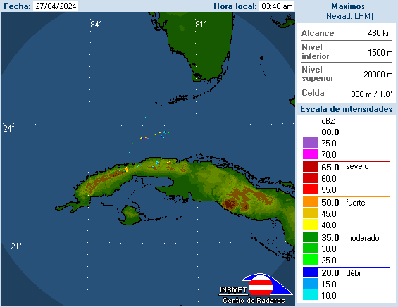
Is detecting heavy rain moving North into the Florida Straits. These pockets of rain will stay on a Northerly track throughout Sunday with most of them staying over the SW Coastal waters.
One or two of these batches of rain may stray east impacting our area throughout the day.
Winds should pick up out of the South.
Sunday Morning Models:

They insist on taking TD 3 near Florida's Big Bend Area. This keeps So FL away from the main strike, but the side impacts may be just as strong.
We will be on the NE side of the system , AKA the "Dirty Sector", and this will mean :
Locally heavy rain and flooding possible, specially for the Florida Keys, SW Florida and the Tri County area.
Official NHC Cone:
Keeps would be "Colin" near the Big Bend.

What to prepare for:
Please keep in mind our impacts will all depend on the exact track and speed of the storm. If it stays on the road the models are suggesting, then this is what we can expect.
NWS says: Our main worry will be in the form of heavy rain
- We may see totals between 2 and 5 inches, with even higher totals by SW Florida.
- Strong Storms
- Windy at times
- The possibility of tornadoes specially for Collier County Sunday night-Monday morning.
- Broward and Miami-Dade may see a slight tornado risk by Monday afternoon.
- They Keys: Will see t-storms with possible offshore winds around 40 mph at times. Expect some pockets of heavy rain.
Already an active Hurricane season. Makes me nervous.
ReplyDelete