Friday, June 26, 2015

The earth is slowing down. What?

That's right. June 30th, 2015 will be a bit longer. The earth's rotation is slowing down. It has been slowing down by very small increments for quite awhile. Its been doing its best to keep pace, but none the less like an aging runner, its not as fast as it used to be.

The earth is slowing down due to a gravitational tug of war between the Earth, the moon and the sun. This tug of war is acting as a braking system.

Scientist say it takes our planet 86,400 seconds to spin on its axis one time. That is how much time is in one day. But since 1820, our earth has been taking a little longer to rotate just one time.

They say our spaceship earth has lost a step or two along the lines of..... are you ready for this?   2 milliseconds, or two thousandths of a second. This may not seem like much, but if we don't adjust for this slow down, we could lose a whole second in one year.

So the time has come to correct this. (Pun intended).
On Tuesday June 30th, the day will be a bit longer as scientists add and extra second to the clock (also known as a leap second). This should help keep all our electronics, clocks and schedules on time.

For more info, here's a great article published by NASA. Its a long read but if you're a space geek like me, you'll enjoy it.:
 

The day will officially be a bit longer than usual on Tuesday, June 30, 2015, because an extra second, or “leap” second, will be added.
The length of day is influenced by many factors, mainly the atmosphere over periods less than a year. Our seasonal and daily weather variations can affect the length of day by a few milliseconds over a year. Other contributors to this variation include dynamics of the Earth’s inner core (over long time periods), variations in the atmosphere and oceans, groundwater, and ice storage (over time periods of months to decades), and oceanic and atmospheric tides. Atmospheric variations due to El Niño can cause Earth’s rotation to slow down, increasing the length of day by as much as 1 millisecond, or a thousandth of a second.
Scientists monitor how long it takes Earth to complete a full rotation using an extremely precise technique called Very Long Baseline Interferometry (VLBI). These measurements are conducted by a worldwide network of stations, with Goddard providing essential coordination of VLBI, as well as analyzing and archiving the data collected.
The time standard called Universal Time 1, or UT1, is based on VLBI measurements of Earth’s rotation. UT1 isn’t as uniform as the cesium clock, so UT1 and UTC tend to drift apart. Leap seconds are added, when needed, to keep the two time standards within 0.9 seconds of each other. The decision to add leap seconds is made by a unit within the International Earth Rotation and Reference Systems Service.
Typically, a leap second is inserted either on June 30 or December 31. Normally, the clock would move from 23:59:59 to 00:00:00 the next day. But with the leap second on June 30, UTC will move from 23:59:59 to 23:59:60, and then to 00:00:00 on July 1. In practice, many systems are instead turned off for one second.
Previous leap seconds have created challenges for some computer systems and generated some calls to abandon them altogether. One reason is that the need to add a leap second cannot be anticipated far in advance.
“In the short term, leap seconds are not as predictable as everyone would like,” said Chopo Ma, a geophysicist at Goddard and a member of the directing board of the International Earth Rotation and Reference Systems Service. “The modeling of the Earth predicts that more and more leap seconds will be called for in the long-term, but we can’t say that one will be needed every year.”
From 1972, when leap seconds were first implemented, through 1999, leap seconds were added at a rate averaging close to one per year. Since then, leap seconds have become less frequent. This June’s leap second will be only the fourth to be added since 2000. (Before 1972, adjustments were made in a different way.)
Scientists don’t know exactly why fewer leap seconds have been needed lately. Sometimes, sudden geological events, such as earthquakes and volcanic eruptions, can affect Earth’s rotation in the short-term, but the big picture is more complex.
VLBI tracks these short- and long-term variations by using global networks of stations to observe astronomical objects called quasars. The quasars serve as reference points that are essentially motionless because they are located billions of light years from Earth. Because the observing stations are spread out across the globe, the signal from a quasar will take longer to reach some stations than others. Scientists can use the small differences in arrival time to determine detailed information about the exact positions of the observing stations, Earth’s rotation rate, and our planet’s orientation in space.
Current VLBI measurements are accurate to at least 3 microseconds, or 3 millionths of a second. A new system is being developed by NASA’s Space Geodesy Project in coordination with international partners. Through advances in hardware, the participation of more stations, and a different distribution of stations around the globe, future VLBI UT1 measurements are expected to have a precision better than 0.5 microseconds, or 0.5 millionths of a second.
“The next-generation system is designed to meet the needs of the most demanding scientific applications now and in the near future,” says Goddard’s Stephen Merkowitz, the Space Geodesy Project manager.
NASA manages many activities of the International VLBI Service for Geodesy and Astrometry including day-to-day and long-term operations, coordination and performance of the global network of VLBI antennas, and coordination of data analysis.  NASA also directly supports the operation of six global VLBI stations.
Proposals have been made to abolish the leap second. No decision about this is expected until late 2015 at the earliest, by the International Telecommunication Union, a specialized agency of the United Nations that addresses issues in information and communication technologies.

Is dry the new normal?

We've been very dry here across South Florida (see previous post for detailed numbers) and if long range outlooks are correct, brown may be the new green. We typically get between 35-45" of rain during the wet season which is about 70% of our annual rain budget. Rain now, we basically have a few drops in the bucket.

Lets take a quick look at the Rainy Season Outlook offered back in mid May.

The forecast:

  • The rainy season officially began May 10th (avg start is around May 20th)
  • Even with the early start, the NWS forecast was for a “Near to Slightly Below Normal” Rainy Season.
  • May and June were supposed to be the wettest with above average rain with drying conditions starting in July and running through mid October.

Rain so far:

  • May rainfall in Miami was only 2.39" with the average being 5.34"
  • Ft. Lauderdale had 1.97" with the norm being 4.65"
  • Key West 1.12" in May, with typical being 3.00"
  • Add to that the June numbers (previous post) and we are way below what's normal. Many areas across South Florida are in drought status.


So if, May and June were to be the wettest of the rainy season, and the upcoming months are forecast to be drier... its going to be very thirsty and hot through the rest of the season. Expect those green lawns to turn a little brown.

How did NWS arrive at the rainy season outlook?:
The outlook of near to slightly below normal precipitation is based on a combination of several factors:

  • Historical data (comparing past summers with similar atmospheric conditions to what is expected this summer)
  • Long-range models
  • The official NOAA Climate Prediction Center outlooks
  • And observed conditions over the past 10-20 years


Back then NWS said the main factor influencing their outlook was the phenomenon known as "El Niño". This is a warming of the equatorial waters of the Pacific which impact both marine and atmospheric wind patterns. Its akin to shaking a snow globe, it messes with the atmosphere causing droughts in typically wet areas and the opposite in the soggy regions of the earth.

They did say: 
Its important to note that not every El Niño event has the same effects on Florida’s weather.

The rainy season usually has three phases:
- Late May through early July (“stormiest” part of the season- and so far its been very dry).
- Early July through mid-August (hotter with dry periods-and its been sizzling so far).
- Late August through mid-October (higher rainfall variability due to potential tropical systems and early-fall cold fronts).

Short term forecast:
We are hoping for some rain this Friday and Saturday as high pressure moves away. If not, next week the high pressure dome that has kept most of the rain away, will return with a vengeance. We'll be back to mostly dry and possibly hotter. Plus, African dust is expected to move in drying us out even more and bringing us hazy skies.


Long range: 
I never thought I would say this, but we need a tropical wave to bring us much needed rain. Keep your fingers crossed.

Thursday, June 25, 2015

Dry and drier

South Florida is dry and getting drier.  The local NWS weather office tells us that we are in:

  • SEVERE DROUGHT CONDITIONS CENTRAL MIAMI-DADE COUNTY
  • MODERATE DROUGHT CONDITIONS REST OF MIAMI-DADE AND BROWARD COUNTIES.
  • THE EASTERN AREAS OF SOUTH FLORIDA ARE IN A MODERATE TO HIGH RISK FOR WILDFIRES 

You have seen the lack of rain and dealt with the stifling heat over the last several weeks. Its been hot and dry even before summer officially started on June 21st.

Since the wet season began in mid May, most of the rain has come down over western areas of South Florida. We've received around 1-3 inches while SW Florida (around Naples) they've seen accumulations of over 4 to 6 inches.

Rain Update:
The National Weather Service provided me the following rain info from January 1st to the present.

  • Miami has received a total of 13.60 " of rain. The average is 23.08". This is a deficit of  -9.48"    
  • Ft.Lauderdale has registered 14.93" since January 1st, with the average being 25.52". This is a shortfall of  -10.59 .

Miami Dade and Broward counties get most of the drinking water from underground aquifers.

Where do they stand?

  • Broward County:  The wells stand at around 10 feet which is near normal
  • Miami Dade County: The wells here are at just under 9 feet which is just shy of the normal.

Continued usage will keep draining these reservoirs and without rain to refurbish them we may be in a pickle. You see, if these wells get too low, salty ocean water can penetrate and contaminate them.

We then rely on water from the Everglades or from Lake Okeechobee to pick up the slack, except the Glades are also running drier, and the Lake is only our secondary source of water.  Right now the lake is not too bad standing at a depth of  12.34 feet with the typical depth at 12.91. Last year we were at  13.95 feet. But everyone including agricultural interests use the Lake, so those levels can drop drastically.

Heat:
Its been hot as well with highs in the low 90s and heat index readings, or the feels like temps, well into the 100+ degree range.

Any hope for rain?
We have been kept hot and dry due to a huge dome of high pressure sitting over us. The models indicate the high starting to weaken today and allowing some rain to move in thru Saturday, but as of this moment, that high is not budging. This worries me because if we don't get some rain relief shortly, next week may be even drier.


The long range models suggest the high staying put and we can add to it a plume of Saharan dust coming all the way from Africa that will dry us out even more. AND, this is where it gets dicey, the forecasts are calling for temps next week to reach the mid 90s.


Please remember:

THE SOUTH FLORIDA WATER MANAGEMENT DISTRICT HAS KEPT ALL OF SOUTH
FLORIDA IN A YEARLY WATER RESTRICTION...WHICH REDUCES WATER USAGE TO
3 DAYS A WEEK. FOR MORE INFORMATION ON THE WATER SHORTAGE CONDITIONS
...PLEASE VISIT THE SOUTH FLORIDA WATER MANAGEMENT WEB SITE AT
WWW.SFWMD.GOV.


Tuesday, June 23, 2015

Wet by the end of the week?

We are watching a wave by the Southeastern Bahamas, and a front that will eventually move towards the Mid-Atlantic States.

For the short term through Thursday:
We will remain hot and steamy with mostly inland storms. You can see on the first map, high pressure dominating our weather with a nice east coast breeze. Rainfall should stay across SW Florida.


Wetter by the end of the week and through the weekend:
On the second map you can see the wave will move to the west, with very little impact, but it may leave just enough moisture in its wake to give us a chance at some showers. The big alleged rainmaker, according to the models, will be a front moving into the Southeast that will help trap moisture over us and give us a better chance for rain.  Heavy rainfall is expected across the Southeast and East Coast.


We need the rain:
Since January 1st, Miami has seen 13.60" of rain. Average is 22.75". We are running a deficit of -9.15"
Since January 1st, Ft. Lauderdale  has seen 14.93" of rain. Average is 25.19". A deficit of -10.26"
Key West is actually on the plus side since the start of the year with 1.28" surplus.

Monday, June 22, 2015

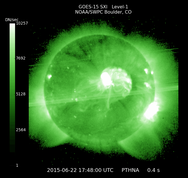
Strong Solar Flare headed our way.

A Coronal Mass Ejection or CME for short is heading directly for Earth, and it is expected to absorb another lesser CME before reaching earth. Its supposed to arrive on June 22nd. A CME is like the sun burping a huge gulp of solar radiation.  The combination of both CME's will likely produce polar geomagnetic storms and high-latitude auroras.

Typically, an ejection of this magnitude could cause satellite outages and cell phone dropped calls. Fortunately, most major satellite agencies can move the satellites and use the earth as a shield to protect them.

Our planet has its own shield called the magnetosphere, it protects us from these sort of eruptions, and in turn it provides auroras at the poles.


The following update is from Spaceweather.com:


SEVERE GEOMAGNETIC STORM IN PROGRESS:
A severe G4-class geomagnetic storm is in progress on June 22nd. This follows a series of rapid-fire CME strikes to Earth's magnetic field during the past 24 hours. Magnetic fields in the wake of the latest CME are strongly coupled to Earth's own magnetic field. This is a condition that could sustain the geomagnetic storm for many hours to come. High- and mid-latitude sky watchers should be alert for auroras tonight, especially during the hours around local midnight.

Monday, June 15, 2015

A New Tropical Storm?

An earlier recon mission did not find a well defined center of circulation in the broad low sitting basically in the middle of the Gulf of Mexico.


NHC, however, suggests that the spiral banding is looking better and it could become a depression or a Tropical storm by tonight. Another recon mission set for 8pm could give us the definitive answer. If it does become a Tropical Storm, it will carry the name of "Bill".


Even if it does not develop, tropical storm force winds could start impacting Coastal Texas by tonight. The big worry will be the rain with some models indicating as much as 5-7 inches over the next few days... some isolated areas may go as high as double digits. This will lead to flash flooding as the ground is saturated from last week's drought busting rains.

Where is it headed?
Most models keep it over Texas, then turn it east aiming for the Middle Atlantic States and the Northeast.


We will remain hot with a chance for some afternoon storms. In other words, our typical summer-like pattern.

Morning Gulf Recon

A hurricane hunter plane is investigating the area of low pressure this morning for possible development.

This area of disturbed weather is basically sitting in the middle of the Gulf.  Thunderstorm activity has become a little more concentrated over the last few hours, and because of this, a recon plane is flying right now into the system to determine its strength.

As of early Tuesday morning, there is a huge cluster of t-storm activity (Reds and oranges) growing around the low.

If this holds up it will be a very soggy event for the Gulf States.

Satellite data suggests that tropical storm force winds (39 mph plus) are in a region east and northeast of the alleged center.

The recon mission should help identify once and for all if we indeed have a depression or a tropical storm in the Gulf. If we have a storm, it will be called "Bill". NHC places a high chance of 80%, on this feature developing over the next 5 days.

Check out what the models are indicating as far as rainfall is concerned over the next 5 days. Over 8 inches in Texas, and even seven inches over Missouri. Some of this rain could reach the Northeast.


Most models are in fair agreement it will continue to aim for Texas.


Whether it becomes a storm, the system could drop plenty of rain over already soaked areas of Texas leading to flooding concerns


Sunday, June 14, 2015

All Eyes on the Gulf

As we head into the upcoming week, NHC is keeping its eyes on a broad area of low pressure in the Gulf of Mexico. Most of the rain with this feature is mostly on the eastern half. There is still some dry air on the Western side keeping it from gaining strength, but this road block may be short-lived,

The Yucatan Peninsula is getting plenty of rain and will continue through Monday.

At this time of year, most tropical activity tends to develop in the Gulf or Northwestern Caribbean Sea and aim either for Texas or Central Florida.

In this case it is most likely headed for Texas.


A recon plane investigated this area of clouds and rain on Sunday, and this is what they found.

Hurricane Hunter Data:

  • They detected a broad area of low pressure basically in the middle of the Gulf. There is also a little wrinkle in the atmosphere near the surface ( a trough ), and another low pressure spin in the upper levels of the atmosphere. In essence, the atmosphere over the Gulf is a bit of a mess.
  • However this mess is not well defined. Showers and storms associated with it are still disorganized.
  • Recon detected a large area of winds over 39 mph (tropical storm force winds) well away from the alleged center of circulation.
  • The current upper level winds are keeping it in check but they should relax in 24 - 48 hours allowing for a depression or a tropical storm to form. 
  • NHC is giving this feature an 80% chance for development throughout the next 5 days. If it develops it will be called "Bill"


Another Hurricane Hunter aircraft will investigate this system Monday morning.


So if it develops, where is it headed?

  • Even if it doesn't become a depression or storm, this area of disturbed weather will aim for the Texas/Louisiana coast. Most models are in fair agreement, the center should impact Texas. These systems tend drop plenty of rain over a large area, so all the Gulf States should be watching closely.
  • Rain could approach the area by Monday or Tuesday, and with the ground already saturated from recent rain, it could lead to flooding. 


What should we prepare for?
High pressure over the Southeastern US, will keep the mess in the Gulf away from us but it will also keep us with a chance of rain just about every day. So expect the possibility of heavy rainfall at any time.


Thursday, June 4, 2015

Possible rainy days

Friday is here and the weekend is just around the corner. The kids are out of school and its time for outdoor activities... well Mother Nature may have other plans, and this outlook may have a Pacific connection.

Hurricane "Blanca" has been sitting just west of Mexico in the Pacific Ocean, no threat to us, and hopefully it will weaken considerably before moving close to Baja California. As it falls apart due to some strong Upper Winds, those same winds could send "Blanca's" moisture our way.


At one time, this hurricane was a category four system with 140 mph winds. It has since weakened to 100 mph, still a category two capable of plenty of damage.

By the time it reaches Baja California it should come down to Tropical Storm status.


 Soggy set-up:

On the big view satellite image, one can see "Blanca", a tropical wave just west of Central America, and an area of low pressure just to the West of Cuba.

But take a close look at clouds coming off the northern periphery of "Blanca". These clouds are getting pushed in our direction by the subtropical jet stream. 

This will be responsible for weakening "Blanca" but it could also drag moisture our way. Add to that the low off Cuba that is also heading here, and we could have enough ingredients for a soupy mess.

Following the Subtropical Jet:
If this recipe remains intact we could start seeing more clouds and scattered pockets of rain on Friday with a better chance for rain over the weekend.

Some long range models hint at the moisture getting stuck over South Florida throughout the early part of next week. 

This rainy scenario is par for the course this time of year as June is the rainiest month followed by September and August.  Make sure you keep your umbrella handy.


Tuesday, June 2, 2015

Tricky Forecast

Sometimes just a few miles can mean the difference between flooding rain or just a few tropical downpours. That is the case facing our weather over the next 48 hours.

The water vapor imagery which shows us where we can find moisture in the mid to upper levels of the atmosphere, shows that our upper air is very soggy, almost like a sponge saturated with water. Any little squeeze and all that rain could come down. The green represents the moisture and the orange indicates areas of dry air.


Most of the time our models are pretty much in agreement and the forecast is rather straight forward, but that is not the case this time.

The following are 2 scenarios that shows how strong upper winds can be the difference between deluge and summer-like rain.

Scenario #1
Notice the red arrows, they represent strong upper winds moving from SW to NE. Behind those strong winds is dry air.

To our South there is a small disturbance loaded with moisture.

To our east high pressure is trapping the moisture over the region. In this scenario, the strong upper winds don't move much allowing all that moisture to arrive as early as the overnight hours and drenching us.


Scenario #2

In this case, the strong upper winds move a few hundred miles to the East pushing most of the rain into the Bahamas. This does not mean we will be completely dry, but it will send the tropical downpours east into the Western Atlantic.


The National Weather Service believes scenario #1 will be the likeliest scenario. Here is their late Tuesday night update:

TONIGHT:

THUNDERSTORMS: SCATTERED THUNDERSTORMS ARE EXPECTED LATER TONIGHT
AND AFFECT MAINLY SOUTHEAST FLORIDA AND THE ATLANTIC AND GULF OF
MEXICO WATERS, WITH LESSER COVERAGE ACROSS INTERIOR AND SOUTHWEST
FLORIDA. MAIN CONCERNS WITH THESE STORMS WILL LOCALLY HEAVY
RAINFALL, GUSTY WINDS AND OCCASIONAL TO FREQUENT LIGHTNING
STRIKES.

OVERNIGHT THE MOST LIKELY SCENARIO IS FOR HEAVY STORMS TO REMAIN 
OFFSHORE THE ATLANTIC AND GULF COASTS, BUT THERE IS THE POTENTIAL
FOR HEAVY RAINS TO IMPACT COASTAL SECTIONS OF SOUTHERN FLORIDA AND
WITH THAT THE CONCERN FOR LOCALIZED FLOODING. GUSTY WINDS ALONG
WITH OCCASIONAL LIGHTNING STRIKES ARE SECONDARY CONCERNS. STAY
TUNED FOR THE LATEST INFORMATION.

WIND: THE STRONGEST STORMS WILL BE CAPABLE OF PRODUCING WIND GUSTS
IN EXCESS OF 40 MPH WITH ANY STORMS THIS EVENING AND OVERNIGHT. 

FLOODING: HEAVY RAIN IS THE MAIN CONCERN ACROSS MAINLAND SOUTH
FLORIDA OVERNIGHT, PRIMARILY COASTAL SECTIONS, WHERE POTENTIAL
IMPACTS INCLUDE STREET FLOODING.

WATERSPOUTS: THERE IS A SLIGHT RISK OF WATERSPOUTS FOR THE GULF
AND ATLANTIC WATERS.

RIP CURRENTS: THERE IS A SLIGHT RISK OF RIP CURRENTS AT THE
BEACHES ALONG BOTH COASTS.

FROM THURSDAY TO MONDAY:

CHANCES FOR THUNDERSTORMS WILL REMAIN THROUGH THE SECOND HALF OF
THE WEEK. THE PRIMARY THREATS WITH THESE THUNDERSTORMS WILL BE
CLOUD TO GROUND LIGHTNING, GUSTY WINDS, AND SMALL HAIL.

AT THIS TIME TRENDS CONTINUE TO INDICATE THE POTENTIAL OF HEAVY
RAIN AND LOCALIZED FLOODING ACROSS MUCH OF MAINLAND SOUTH FLORIDA 
THROUGH THE WEEKEND.