September 10th is the peak of hurricane season. This is the time of year when we tend to see the most activity in the tropics, and as we look out into the Atlantic Basin we can see why.

Thursday morning the National Hurricane Center (NHC) issued its Tropical Outlook, or areas they are monitoring, and the tally is 7.
Lets look at them one by one:
- Yellow X by the Carolinas- Is a disturbance with some shower activity that is expected to fall apart soon. Good news here.
- Yellow X East of the Bahamas- is an area of clouds and rain that will move over the Bahamas & So. Florida over the next 24 hours, with the possibility to deliver more rain. Once it moves into the Gulf it will have a chance to develop as it moves away from us.
- Yellow X in Gulf of Mexico is new as of Thursday morning, Small disturbance moving SW. It has a low chance for development over the next 5 days.
- In the middle of the Atlantic we find two Tropical Storms, Paulette and Rene. No worries from Rene but Paulette could impact Bermuda by Tuesday before it turns north away from the U.S.
- Red X by West Coast of Africa is a tropical wave just moving into the Atlantic Ocean, It has a 90% chance of developing into a depression or a storm in the area highlighted in red. Needs to be watched by the islands.
- Orange area over the Cape Verde Islands-is where NHC thinks another wave in Central Africa may develop once it moves offshore.
Latest on Paulette

In the short term, Paulette is expected to intensify and possibly impact Bermuda by Tuesday as a category 1 with 85 mph winds.

In the long term, models show the jet stream pushing along a front with a huge dome of high pressure that will deflect it from the U.S. Keeping fingers crossed all these features will pick up speed and help Bermuda.
The rest of the Tropics
Not too worried about all the yellow and orange areas, however, the red X, needs to be watched. Very Early model runs suggest a developing system near the Islands in the days ahead.
Euro Model:

By September 18th, it shows a small dot south of Haiti/Dominican Republic. This is signaling the start of a depression or a storm.
Canadian Model:

On the same date, this model shows a much stronger swirl around the same geographical area. Anything developing this strong in this region needs to be monitored by everyone.
GFS Model

Also on the 18th, this projection shows a strong system developing but closer to Puerto Rico.
The bottom line is everyone should monitor the progress of that red X emerging from Africa on this Thursday.
La Niña Outlook
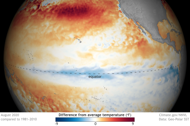
We all know El Niño, a warming of the equatorial waters of the Pacific Ocean. It can cause worldwide storms, droughts and other severe weather events, but it keeps hurricane formation somewhat in check. La Niña, is its sister, a cooling of the Pacific Waters. Unfortunately it does nothing to curtail storm formation in the Atlantic Basin. The newest outlook calls for La Niña to remain through winter. We remain vigilant to whatever may form down the road.
We'll be watching
No comments:
Post a Comment