Thursday, March 17, 2016

St. Patrick's Comet?

Just in time for St. Patrick's day, ah well, not really... but close enough, a green comet will make a close approach to earth. You may be able to see it on Internet sites, unfortunately for us it will only be visible in the Southern Hemisphere.

For you Comet Lovers here's the info:
This "Green Comet", will fly by on March 21st. Its officially known as "Comet 252P/Linear and according to Spaceweather.com, it will be the 5th closest comet fly-by on record. It will be a mere 3.3 million miles away as it nears the earth, thus a true delight for backyard astronomers. As it gets closer, it should get brighter and brighter. Plus, there is a bonus, its being accompanied by a smaller comet known as "P/2016BA14". This one will be even closer to earth passing by on the following day.(it will not be as bright)


But why is this comet green?
The comet is green because the nucleus, or the center, is spewing out diatomic carbon, C2, vapor (A gas which glows green in the near-vacuum of space).The green will turn brighter in the nights ahead as 252P/LINEAR approaches Earth. 

According to the International Meteor Organization,  there is a chance that the fly by could cause a minor meteor shower. This could happen on March 28–30.

Thursday, February 25, 2016

February will be 1 day longer this year

Typically this month has 28 days, but not this year. This time around we will have 29, go ahead check your calendar.

When this happens, its known as a leap year. Instead of having 365 days we will end up with 366. But why?

What is a leap year?
A leap year gets one extra day to keep our calendars in working order. It keeps the seasons and holidays happening at the same time. Without knowing the start of spring for example, farmers would have a difficult time knowing when to seed.


A typical year, to be precise,consists of 365 days, five hours, 48 minutes and 45 seconds. This is how long it takes the earth to go around the sun once. But Mother Earth is slowing down. If this process continues unchecked for hundreds of years, Halloween may end up 
falling on November 2nd! After 750 years for example, June would start in the middle of winter.

How did we correct it?

Very long story, but even thousands of years ago, a Greek astronomer by the name of Hipparchus, realized something had to be done. He did the math and figured out if 1 extra day was added every 4 years, he could compensate for the slowdown allowing all the holidays and seasonal changes to take place on the same dates.

Problem solved?
Not quite, nothing is ever that simple. When you factor in the earth's orbit, it's rotational speed slowing down, etc...more adjustments needed to be made. We know about the Leap Years, but every so often we need to add an extra second to the year. (Here's where it gets a tad complicated)

Leap seconds!
The first leap second was added in 1972. Back then we were about 10 seconds behind where we should be, according to the Atomic Clock (don't ask). Since then, we've added 26 leap seconds to accommodate the earth's slow down. (Don't we all slow down when we get old?) The last time we added a leap second was June 30th, 2015.

So we're back on track?
Kind of. (Here comes the headache) Because time and earth's orbit are not 100% precise, this whole business of adding an extra day every 4 years gets thrown out the window, every 100 years.

Every 400 years we go back to adding the extra day. But not always so. For example in the year 2000, which was also a leap year, we should have gone back to skipping the extra day. But, here we go, since it was also divisible by 400, the 100 year rule was  ignored.

Experts say, "This long-term solution creates an average year length of 365.2425 days, still slightly off the required target of 365.2421897 days, making even this complicated modern arrangement incorrect by one day over a period of just under 4,000 years."

I need a drink! Enjoy the extra day!

Wednesday, January 20, 2016

Hottest year since the 1800's

Last year was the hottest by far across the world according to a report issued by NASA and NOAA.

On Wednesday, January 20th, NASA provided data showing global temps rising from 1970 thru 2015. The graph shows a steady rise in world wide temps starting around mid 20th century.


The info was compared using numbers from 1880 until 1899 when fossil fuel emissions were almost non existent. They concluded that since then, the earth has warmed up almost 2° Fahrenheit.  Most climatologists suggest this may be the tipping point where climate change may not be reversible.

The starting image begins in the early 70s as we are still relatively average....


And finish with imagery from the last 4 years showing a warmer planet.
 
 NASA adds, the same referenced time frame shows a continuation of a long term trend of global warming.

The heat was not only here , according to NASA,  "the month of December, 2015, 29 US states had the warmest December on record by nearly 6 degrees F, and parts of Europe also had a record warm December", they add  "the current El Niño has played a part in the warming, but 2015 would be a record with or without El Niño."

As you know, in 2015, South Florida had the hottest year since records have been kept starting in the late 1800's and also the warmest December on record. 

Local NWS says:
Lead NWS Miami Meteorologist Robert Molleda said, “If one word can describe South Florida’s weather in 2015, it would be HOT,” he concluded by saying, “It will go down as the hottest year on record at all four main climate sites.” 


Tuesday, January 19, 2016

Cold now, Cold later

Wake up temps on Wednesday should be in the low 50°s over many areas across Dade and Broward, with the Keys possibly seeing the mid to upper 50°s. Clouds will remain intermittent as they are seen on satellite stretching all the way back to the Yucatan Peninsula.

By the afternoon, temps should return to mild readings with highs in the low to mid 70°s.

We will then continue our temperature roller coaster ride as we head into the weekend, and the early part of next week as yet another front invades the region.


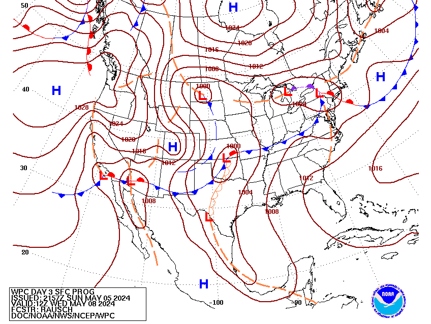
The next front is presently sitting over Texas. It will move our way and should provide some rain by Friday, but just how much is still not clear. The reason for the uncertainty, is the possible emergence of a low by Cuba.

Two things can happen:
Scenario1: 
The European model suggests a low brewing just to our South, possibly over Cuba, and moving North.

This may help spark some strong storms by the end of the week over South Florida.


Scenario 2:
The GFS model is not so bullish on the developing low.

If this is to be, then we should just get some rain without the threat of nasty weather.


Right now all we can do is wait, see, and monitor the area just to our South for any possible organization.

If it does come about:
After it leaves us, it may ride right up the East Coast dropping rain, and Snow throughout its path. Something they will have to keep an eye on.

This is what NWS National is saying:
Monitoring the possibility of a major winter storm affecting the Northeast later this week, including the possibility of heavy snow for the urban corridor extending from Washington, DC, to New York and Boston Friday into Sunday. Based on the anticipated storm track, as much as 1 to 2 feet of snow is possible near and northwest of I-95. Coastal flooding is also likely.


The low may be across the Southeast, aiming for the Northeast by Friday morning.


Thursday, January 14, 2016

Weird Wacky Weather

Record heat in December, warm Christmas along the East Coast, cloudy and rainy in January, and now a hurricane in the Atlantic.

Is there an explanation for this? Many blame El Niño. We've been hearing about it since before the start of hurricane season 2015.

According to Scientific American, "the current 2015–16 El Niño is one of the three strongest ever recorded. The other two occurred in 1982–83 and 1997–98".   Many in the media are referring to it as 'The Godzilla El Niño".  Worst yet, it should hit its peak this winter.


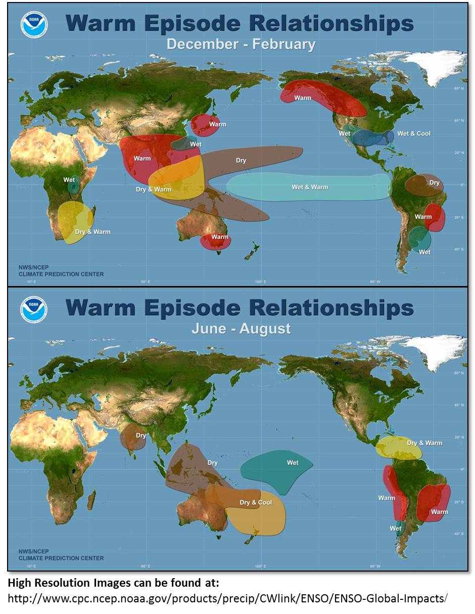
For those who may not know, El Niño is a warming of the equatorial waters of the Pacific Ocean. It messes with marine and atmospheric currents alike making for wet conditions in typically dry areas and vise versa.

This phenomenon may cause nasty storms that impact the west coast of the US, but not all storms are sparked by El Niño. Again, in an article by Scientific American, they explain, "storms may be influenced by “El Niño but not one storm can be called “an El Niño storm.”

However, there is something that may be a direct impact. The warming of the Pacific waters caused a very active 2015 Pacific season. Here's the end-of-season report from NHC:

For the 2015 hurricane season overall, the basin was very active
with 18 named storms, 13 hurricanes, and 9 major hurricanes. There
were three unnamed tropical depressions and another tropical
depression that formed in the basin that became a tropical storm
(Ela) in the central North Pacific. Activity for 2015 was well above
the long-term means of 15 named storms, 8 hurricanes and 4 major
hurricanes. The number of major hurricanes observed in the basin in
2015 was the highest since reliable records began in 1971.

On the other hand, "El Niño" made for a quieter hurricane season in the Atlantic basin.

The bottom line is that Mother Earth is constantly changing and its difficult to pin point any one single entity responsible for all the "Strange" weather we've seen lately.

None stranger than a winter hurricane. As of  Thursday January 14th, there is a category 1 system in the Eastern Atlantic by the name of "Alex". It should impact the Azores before dissipating over the weekend in the cold waters of the Northern Atlantic.


So is this part of "El Niño"?, Not really. Most of "El Niño's" impacts tend to be across North America and parts of South America.  "Alex" may just be a fluke.


This is not without precedent: Back in 1938 a Hurricane developed on January 1st with winds of 80 mph. Then there was "Alice", which became a category 1 on December 31st 1954, and lingered into January of '55.

We will continue to monitor "El Niño", the melting of Polar Caps, and all the other climate factors influencing our weather. This winter may be more active than we'd like it to be.

Thursday, November 5, 2015

Late Season Action?

We are almost done with hurricane season, that being the end of this month, yet Mother Nature is keeping us a little busy.  Two areas are being watched for possible development. One has not even materialized yet, and the second is in the Western Caribbean Sea. The "Worry Factor" is zero regarding any of these systems making it to Florida.


The area being watched near Puerto Rico, Dominican Republic and Haiti is being forecast by models to maybe develop over the weekend.

 There is nothing there now but NHC says there is a 20% chance that an area of low pressure will develop just north of the area.


It will be a tad difficult, though not impossible, for systems to develop since we are in the middle of an El Niño year.

This phenomenon helps cut the tops down of any developing system.  All we can do is watch, wait and see what happens.

If it does make it, it will probably move northwest until upper winds begin pushing it back out to Sea.


The second area, is a low in the Western Caribbean Sea.

It should provide rain over the Yucatan, then move into the Gulf of Mexico, where it may dump rain across the Gulf States and finally get absorbed by a front.

This front may bring us rain here by the weekend.


We'll keep you posted. 

Wednesday, October 21, 2015

Asteroid Close Call - by Universe standards

It has been dubbed the "Halloween Fly-by" and nicknamed "Spooky" by scientists. Its official name is "Asteroid 2015 TB145".

This is a recent discovery by NASA, spotted for the first time October 10th. Its making a bee line for our neck of the woods and should pass by, from a safe distance, on Halloween afternoon. It should stay as far away as the moon, it may seem far but by Space Standards, its a close shave. The asteroid will fly past Earth on Oct. 31 at 1:05 p.m.

This Halloween Asteroid is about 1,300 feet wide, and it will supply NASA with plenty of data for research. It will be close enough for all sorts of earthbound instruments to track.


NASA says:
According to the catalog of near-Earth objects (NEOs) kept by the Minor Planet Center, this is the closest currently known approach by an object this large. By the way, the next close Asteroid fly-by will be "Asteroid 1999 AN10". Its about 2,600 feet in size, and will pass about the same distance from earth as the moon is from us (238,000 miles) in August 2027.

The "Halloween Asteroid" should pass just over 300,000 miles away. Even though its close it will not be easy to see. You will need at the very least a small but powerful telescope.

Any Scary Impacts from this Asteroid?
NASA says:  The gravitational influence of the asteroid is so small it will have no detectable effect on the moon or anything here on Earth, including our planet's tides or tectonic plates.

Friday, October 16, 2015

Interesting 48 hours

The forecast over the next 2 days will be a little tough. We are surrounded by many features that could make for a soggy weekend. You can even throw into the mix some tropical activity in the long term.

We begin with a front aiming for us.
This front should stall over South Florida over the weekend. Depending on where it sets up, this will dictate where it will rain.

If it stalls by the Straits... more rain for the Keys and less for us, but if it stalls over Miami-Dade & Broward, the rain will impact the mainland.

Add to the mix, a broad area of low pressure, presently featured as just clouds and rain.

 Its located in the Western Caribbean Sea, loaded with moisture and moving west. 

If it can survive its trek over land, it should emerge across the Bay of Campeche in the SW Gulf of Mexico.

NHC is giving this feature a 20% chance for development over 5 days.

If it can make it there, everyone across the Gulf States should monitor it closely.

For the time being, its expected to drop plenty of rain across Honduras, Belize, and the Yucatan Peninsula.

This may lead to localized flooding, land and mudslides. We'll be watching closely.


Back to South Florida. 
As the front approaches, winds should veer out of the Southwest.

This may give the front a chance to tap into all the tropical moisture related to the broad low. This connection could make for a soggy weekend.

The local NWS office expects the wind to pick up making for choppy seas. This may not be the best of weekends to be out on a boat.

Check out the latest outlook:

INCREASING NORTHEASTERLY WINDS WILL BRING BUILDING SEAS AND
DETERIORATING BOATING CONDITIONS FOR BOTH THE ATLANTIC AND GULF
WATERS LATE THIS WEEKEND AND THE BEGINNING OF NEXT WEEK.

THE RISK OF ATLANTIC COAST RIP CURRENTS WILL ALSO INCREASE THIS
WEEKEND AND THE BEGINNING OF NEXT WEEK.

THERE WILL BE A SLIGHT RISK OF THUNDERSTORMS THROUGH THE WEEKEND
OVER SOUTH FLORIDA. THE PRIMARY THREAT WILL BE CLOUD TO GROUND
LIGHTNING STRIKES.

Keep it tuned to WSVN for the latest.


Friday, October 2, 2015

Joaquin: Can South Florida finally breathe easy?

UPDDATE: As of 11am, Joaquin is finally moving north.

Its very difficult not to be concerned when there is a category 4 system a mere 400 miles to our east. Its a big one also with its cloud canopy extending from Haiti/Cuba and throughout much of the Bahamas.

The Central Bahamas have been dealing with "Joaquin's" wrath since early Thursday morning, they are still getting hammered at this hour, and it may not be until tomorrow that the system will finally leave the area.

From e-mails and text messages I've received, it is not a pretty sight with wind, rain, and waves battering the islands with plenty of flooding.

I'm sure when the reports start coming in from the Central Bahamas, it will be devastating. My thoughts are with all of our neighbors to the east.

For South Florida, it appears the much anticipated turn has begun. It started Thursday night at 11 pm when Joaquin stopped moving WSW , slowed down and started drifting due west. By this morning , the movement is now in a NW direction and should eventually aim north later on today. This should finally end the misery for the Bahamas and start taking it away from us as well.

Outside of a few models, most are in agreement Joaquin should stay offshore through its duration.
This is the latest from NHC:

The forecast models continue to indicate a track offshore of the United States east coast from the Carolinas to the mid-Atlantic states, and the threat of direct impacts from Joaquin in those areas is decreasing.

However, there is still uncertainty in how close
Joaquin could come to Bermuda, extreme southeastern New England/Cape Cod,
and Nova Scotia during the next several days, and interests in those areas should continue to monitor the progress of the hurricane.

A Tropical Storm or Hurricane Watch could be required for Bermuda later today.

What can the US East coast expect?
From NHC:

Even if Joaquin remains offshore, strong onshore winds associated with a frontal system will create minor to moderate coastal flooding along the coasts of the mid-Atlantic and northeastern states through the weekend.

In addition, very heavy rains, not associated with Joaquin, are expected to produce flooding
over portions of the Atlantic coastal states.

Since it appears South Florida is spared, will we see any indirect impacts from Joaquin?

This is what our local NWS office expects over the next few days.

HAZARDOUS SEAS...ATLANTIC AND GULF STREAM SEAS ARE FORECAST TO
REACH 6 TO 7 FEET BY EARLY SATURDAY THEN CONTINUING THROUGH AT
LEAST SUNDAY WITH A SMALL CRAFT ADVISORY LIKELY TONIGHT.

POSSIBLE HIGH SURF ADVISORY...THE COMBINATION OF THE CONTINUING
HIGHER TIDES...THE EXPECTED ARRIVAL OF THE LONG PERIOD SWELL AND
RESULTANT BREAKING WAVES MIGHT WARRANT A HIGH SURF ADVISORY FOR
PORTIONS OF THE ATLANTIC COASTAL ZONE BY LATE SATURDAY THROUGH AT
LEAST SUNDAY...MOST LIKELY FOR PALM BEACH COUNTY AND NORTHERN
BROWARD COUNTY. ADDITIONAL GUIDANCE OVER THE NEXT DAY OR SO WILL
HELP IN REFINING TIMING AND LOCATIONS AND IF AN ADVISORY WILL BE
NECESSARY.

Tuesday, September 29, 2015

Bahamas Hurricane Threat?

T.S. Joaquin is aiming for the Bahamas and getting stronger as of Tuesday night.


Satellite imagery suggests its getting well organized with feeder banding starting to show with some outflow being detected in the upper levels. Most of the models suggest additional intensification over the next few days.


Already the Southeastern Bahamas are getting some rain associated with this system.

"Joaquin" will prove to be a "Nerve-Tester" as it may reach 90 mph winds by Friday as it nears the Central and Northwestern Bahamas.

Then most models stop it on a dime and push it due North keeping it over the Atlantic Waters.

After that dead stop, the models fan out with some taking "Joaquin" into the Mid Atlantic States and others as far east as Bermuda.


The reason for this sudden stop and turn is due to a front being pushed along by the Jet Stream.

This combo will act as a wall deflecting the storm from the Bahamas. BUT, it may be a close call, everything depends on how fast the jet and front move down.


  Two things can happen, Scenario #1:

If the Jet and associated front are too slow moving south, this will allow for "Joaquin" to possibly impact the Bahamas.

It could be a 90 mph hurricane by then or maybe stronger. Intensity forecasting is not precise and it has a chance for further growth. 


Scenario #2:
If the jet/front move in fast enough, it should deflect "Joaquin" north keeping it away from land, at least for the short term.  We'll be watching.


Monday, September 21, 2015

Going Loony for rare Super Lunar Eclipse


This upcoming weekend you will witness a very cool lunar eclipse. Don't miss it because the next one won't take place until 2033.
 
Lunar eclipses are not that rare, but what makes this one unique, are three celestial events tied into one.

First you have a full moon, second a lunar eclipse, and third , all this takes place when the moon is closest to the earth. The moon's orbit is not circular but elliptical, this means its closer to us at times and farther at others.

The last time this "Supermoon Eclipse"  happened was in 1982; there were just five instances of it in the 20th century.

With these three features in place, it should be a  very cool event to witness.

So what can we expect:
  • The moon will be fully lit in all its celestial glory, a full moon this weekend.
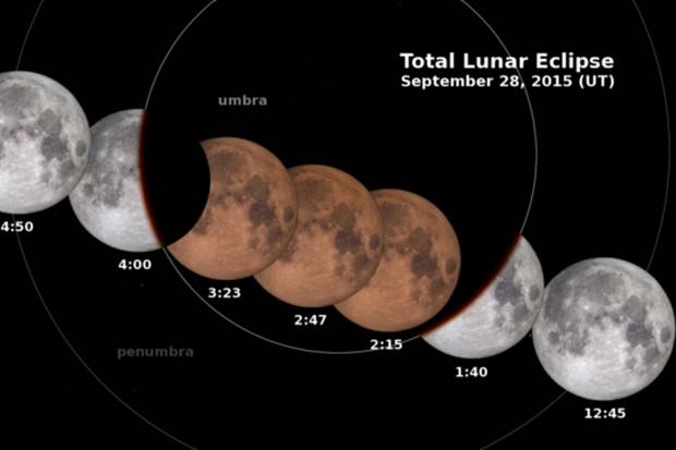
  • The lunar eclipse happens on Sunday September 27th. This is when the earth blocks the sun's light from hitting the moon. In essence the earth's shadow will cover the moon.
  • Lastly, all this takes place during lunar perigee, when the moon is in the closest part of its orbit to Earth.(also known as a Supermoon)

The following is from Space.com
During lunar perigee, the moon appears larger and brighter in the sky, which is why a full moon coinciding with perigee is known as a "supermoon." (A "minimoon" is when the full moon is at its farthest point from the Earth.) This large moon will present the perfect canvas to watch the Earth's shadow slide over and block the moon's light. 

The moon will be shrouded in shadow Sunday night or early Monday morning.
It will enter the dark part of the Earth's shadow at 9:07 EDT Sunday, and it will enter a total eclipse by 10:11 p.m. EDT  before it begins to emerge from the shadow 12 minutes later. 
Areas that cannot see the full eclipse, because sunset comes too late or sunrise too early, may still be able to see part of the moon obscured.


And if that wasn't enough:
This eclipse carries another name as well, "Blood Moon"
The moon doesn't simply disappear into Earth's shadow during a lunar eclipse; instead, it's illuminated by an eerie, reddish glow of the light refracting through the edges of Earth's atmosphere.

Check out this explainer video, again courtesy of Space.com:
Click here for a quick video of the Lunar Eclipse


Wednesday, September 16, 2015

New Depression # 9 plus loss of Arctic Ice

NHC is watching two areas in the Tropics. One is a depression, the ninth of the season, and the other a low in the Far Eastern Atlantic with a good chance for growth.

Tropical Depression #9
Is roughly 1200 miles East of the Lesser Antilles. Top winds as of this posting are at 30 mph and it is moving slowly to the NNW at around 8 mph.

Its not looking too healthy on satellite imagery. Strong upper winds are impacting it already and most of the rain is to the east of the center. This feature may not last too long.

Most models keep this depression over the open waters of the Atlantic. NO Worries for Us or the Lesser Antilles.


There is another broad area of low pressure near the Cape Verde islands which continues to get its act together.

Its roughly 400 miles SW of the Cape Verde Islands.

Over the next few days, the atmosphere surrounding this low will become favorable for growth.

It could become a depression/storm over the next 5 days.

This is what NHC is saying about it:

They are giving it  an 80% chance for development over the next 5 days. Even if it develops, models here too keep it as a worry only for the shipping lanes. 

The models project its path almost following
the footsteps of TD #9.

No worries for the islands, nor for us
here is South Florida.


Meanwhile, we are losing Arctic Ice very fast. A new NOAA reports a record loss coming in, in 4th place among the worst ice losses since the 70's.

This is their update:

Scientists report (today, 9-15-2015) that the Arctic sea ice summertime minimum is 4th lowest on record.
 #1.  Analysis of satellite data by NASA and the National Snow and Ice Data Center indicates that the accelerated summer melting trend since the late 1970s continues.
 #2.  This increased melting is a response to the warming global temperatures.
 #3.  It is unclear whether this year's strong El Niño has had any impact on the Arctic sea ice.
Tag:  Weather and climate researchers are continuing to study the possible effects of 
the increased open Arctic waters in the autumn might have on jet stream patterns over the United States and snow storm development in the winter season.

Friday, September 11, 2015

Strongest El Niño ever?

We've heard a lot about "El Niño" this year. This is a warming of the Equatorial waters of the Pacific Ocean that not only impacts marine currents, but atmospheric ones as well.

It has a global reach...rainy where's it typically dry and vice versa. It also helps keep hurricane formation in check in the Atlantic basin. Strong upper level winds ride out of the Eastern Pacific only to cut down the tops of any developing system on our side of the world. For us in South Florida,"El Niño" is our Tropical Friend.

Forecasts have been calling for a very strong "El Niño" this year, maybe even a record setting event.

NOAA says:
The three-month, June-August average of sea surface temperature ran 1.22°C (About 2 degrees F) above normal.
This is the third-highest June-August value since records started in 1950, behind 1987 (1.36°C) and 1997.

The "El Niño" event of 1997 was one of the strongest on record. This image shows a side by side comparison on 1997 and now.
 
NOAA adds that:
“There is a greater than 90% chance that El Niño will continue through Northern Hemisphere winter  2015-16, and around an 85% chance it will last into early spring 2016.”

The red tones indicates hotter temps, while the blues show cooler water temps. Typical temps are in yellow.

So what does this mean?
A strong "El Niño" during the winter typically means wetter weather for the West Coast. This could mean much needed rain for California and its drought.

It could also mean land and mudslides with very strong gale force winds.


For South Florida?
El Niño conditions usually bring cool and wet conditions to our region, specially from December through February. 


These are the possibilities of a Freeze for the counties in Florida during an "El Niño" year.


  We'll keep you posted on the progress of this Possible Record Setting El Niño.