Monday, May 21, 2018

Tropical Trouble Close to Home?

The National Hurricane Center (NHC) has upped the chances for development for a disturbance in the Caribbean from 20% to 40% as of 8 pm Monday night.


NHC now says it is a broad area of low pressure dumping plenty of rain across Cuba, the Caribbean Sea, and the Caymans. Models show some of that rain moving in our direction in the days ahead.


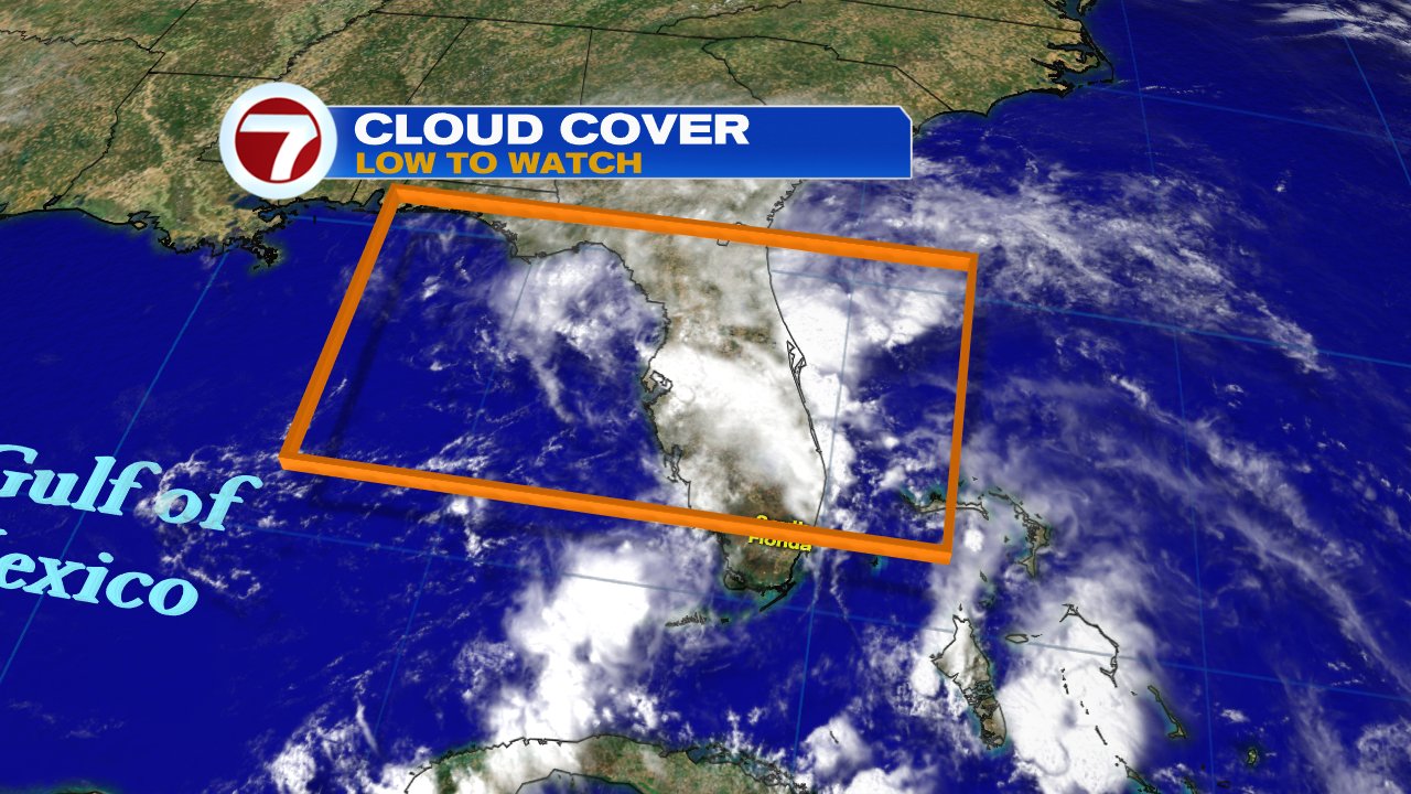
From the satellite picture above one can see very few clouds where the low is situated, a couple of hundred miles East of Belize. Most of the clouds extend in a tail across Western Cuba north into South Florida. Monday saw heavy rain across the Lower Keys with totals as much as 3 inches. Conditions are not conducive for any development now, but that may change in the days ahead.


The low should get pushed into the Gulf in about 48 hours and by then atmospheric conditions will become favorable for gradual development of a subtropical or tropical system. Even if nothing forms, there is so much moisture near us, that we could get another soaking thru the Holiday Weekend. We are hoping this area of rain falls apart.

Models

NHC has deemed this "Invest 90L". Which means this is an area that needs to be INVESTigated further, 90 is a tracking number, and "L" stands for Atlantic Basin. We have two models to look at. We begin with the European
 

This scenario shows system organizing early Friday morning in the middle of the Gulf of Mexico, and then aiming for the Louisiana-Pensacola area. It places heavy rain over us.

The American model


In this scenario, a system develops much later in the time-line, by Saturday,  but it aims for the Keys, South Florida, & maybe the Bahamas. It too pushes heavy rain our way.


The bottom line is that Cuba, South Florida, and the Bahamas could see copious amounts of rain from Wednesday thru the Holiday weekend.  Please monitor the situation. The ground is near saturation in many areas and drenched in others.


Rainy Memorial Day weekend?

Its been very soggy across South Florida since last weekend, it'll be wet on and off this week, and Memorial Day weekend promises to be stormy as well.


We have deep tropical moisture moving across the state keeping us with a chance for downpours throughout the next few days. In the satellite loop above, its hard to see the state of Florida from space as it is obstructed by cloud cover. By the end of the work week, chances may turn even higher as tropical trouble could spin up in the Gulf of Mexico.

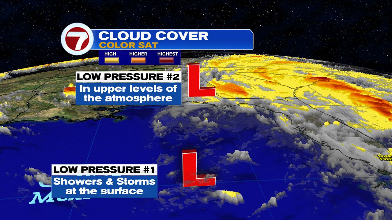
The National Hurricane Center (NHC) says the cloudiness is due to a large area of low pressure in the upper levels of the atmosphere which covers the area from Florida south over Cuba and into the Northwestern Caribbean Sea. 


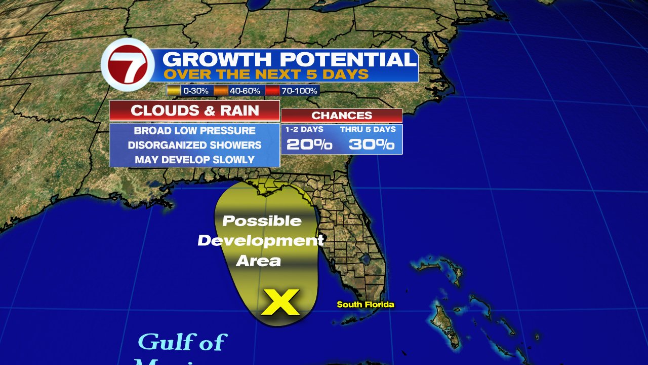
Add to this a disturbance at the surface  in the Caribbean and you have plenty of instability in the atmosphere to keep us rainy in the days ahead. This same combination should PREVENT anything tropical from forming, but NHC says that in the long run, possibly by the weekend,  things may change. As the disturbance moves into the Eastern Gulf of Mexico, conditions may improve for organization. They are giving it a 20% chance for formations.  Even if it doesn't develop, heavy rain could be the norm for South Florida, NW Bahamas, & Western Cuba.

This is a good time to check your hurricane season supplies. The season officially starts June 1st.


Friday, May 18, 2018

It could be a very wet weekend

Conditions are setting up for South Florida to get heavy rain both Saturday and Sunday. 
If nothing changes, the first half of the weekend could be the wettest. 
Mother Nature gave us a nice and mostly dry day on Friday, but it appears its came at a price.

Our tropical moisture-pipeline is still intact and models are suggesting it will continue to drag rain here.


The wind flow over the Gulf of Mexico is from the southwest, while in the Atlantic its from the southeast.  This combo will draw moisture from the Tropics and bring us a good chance for heavy rainfall.  

If all the ingredients fall in place, chances for rain will stay very high over the next 48 hours. The National Weather Service says, that we could see anywhere between 3 - 5 inches of rain with higher amounts possible. Despite the ongoing drought conditions, it may flood if the heavy rain materializes.  
 Because of this potential for heavy downpours, a Flood Watch may be issued for South Florida this weekend.  Stay tuned to WSVN, for the latest updates.  


Notice next week is also being forecast to end up wet, that's because the models are picking up additional mositure from the Western Caribbean invading South Florida by then.


Tuesday, May 15, 2018

Recon on Stand-by for Gulf Low

A Hurricane Hunter is set to investigate the Gulf of Mexico disturbance on Tuesday if needed.


Over the last few days the National Hurricane Center has been giving this feature anywhere between a 20% to a 40% chance for development. If it does organize, it can do it anywhere in the area highlighted below as it slowly moves northward.

NHC added: Although the low could acquire subtropical characteristics over the next few days, it has shown little signs of organization. A subtropical system has a cold center while a tropical low has a warm core.


The disturbance is made up of two low pressure systems. The first is at the surface. Its trying to get organized, but the second low in the upper levels of the atmosphere is interfering with it and not letting it get its act together. While this may be good news, it will keep South Florida on the wet side for days.


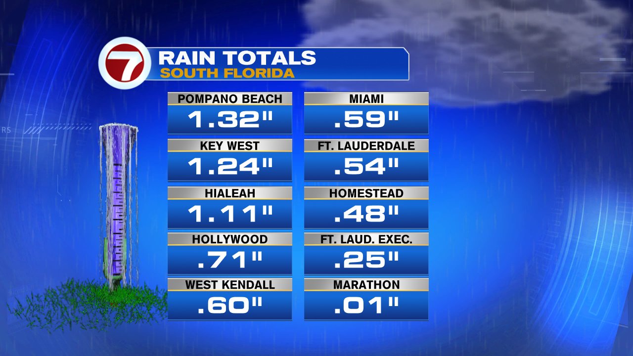
On top of the rain we had over the weekend, many areas across South Florida had big downpours on Monday. While Marathon remained mostly dry, other cities got soaked with over an inch of rain.


This disturbance is capable of producing widespread downpours over South Florida that may lead to street flooding. We've seen some standing water in low-lying areas, and the local National Weather office suggests an additional 3 - 5 inches is possible in total rainfall through the upcoming weekend.


Sunday, May 13, 2018

Tropics Heating up in the Gulf

This coming week may see tropical activity develop in the Gulf of Mexico. A large area of clouds and rain impacting most of Florida, has a small chance at development.

As of  10 am Monday morning, the chances for development stay the sam as indicated further down in the blog. 


Hurricane season officially starts June 1st, but that is a man-made timeline. 
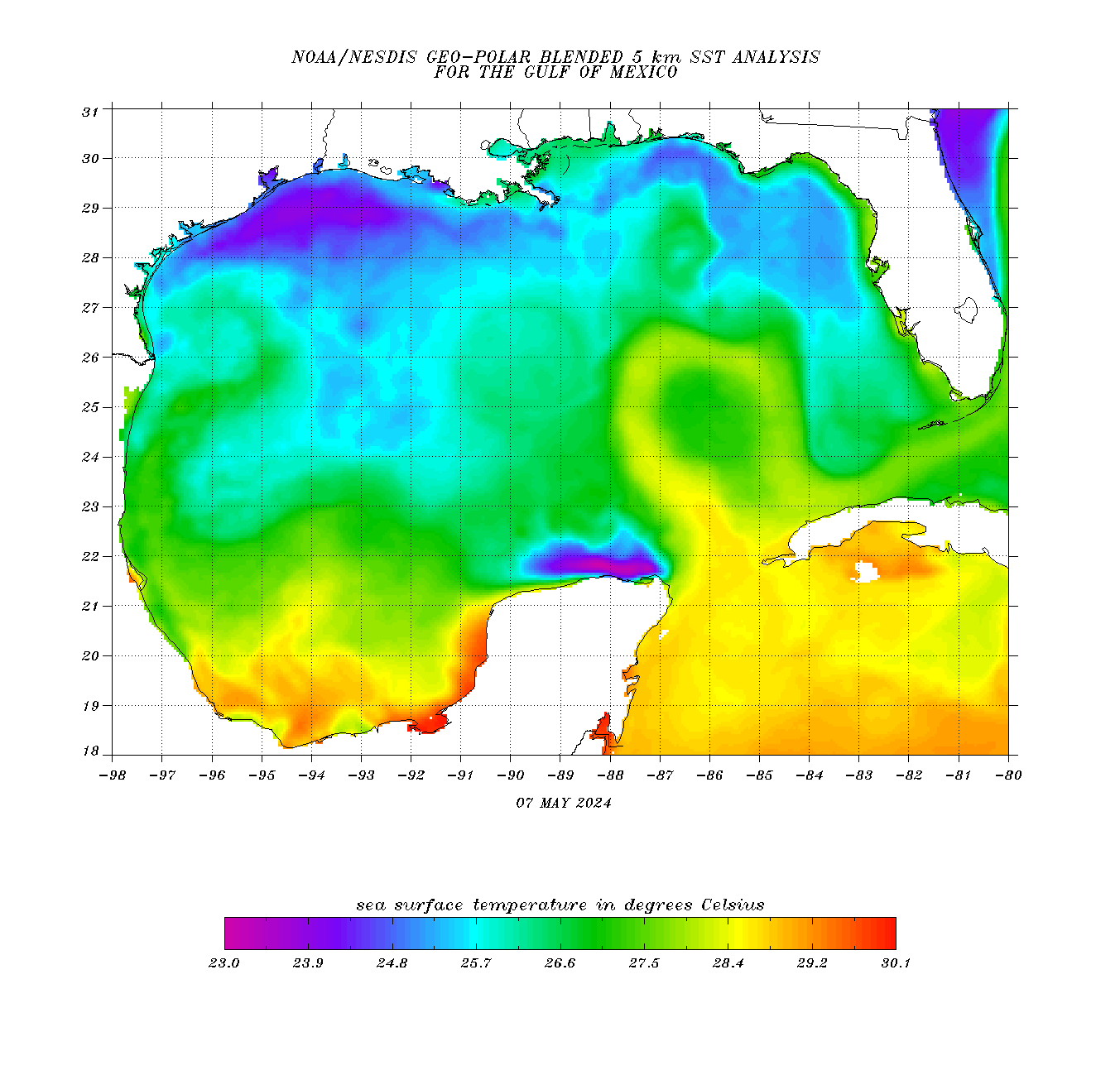
Tropical systems can occur at any time as long the ingredients for organization are met, and the main ingredient is hot water.  In order for systems to develop, you need at least 80 degrees of sea surface temperature. The Gulf of Mexico is one of the quickest bodies of water to warm up. Temps are presently running in the upper 70's closest to Florida's west coast (blue shaded area), but near 80 in the green and yellow areas.

NHC is Monitoring

Over the weekend the National Hurricane Center (NHC),  issued an outlook on the potential for a system to develop in the Gulf, either tropical or subtropical. Tropical basically meaning it has a warm core, while sub tropical typically has a cold center. Regardless of development, this feature can drop plenty of rain from Florida thru the southeast.


This is what they said:

A large area of clouds, rain and thunderstorms stretches from Western Cuba into the SE Gulf of Mexico, the Florida Straits, and the rest of the state. This is associated with a broad area of low pressure interacting with another low in the mid to upper levels of the atmosphere. It could develop tropical or subtropical characteristics as it moves northward in the Gulf over the next few days.  It has a 30% chance for development in 48 hours and a 40% chance over 5 days


An update on its chances for development will be issued Monday at 11 am.  If it were to organize, it would do so in the are highlighted in orange.

What are the models saying?

Lets take a look at three model outlooks for the 15th of May.

The ECMWF model, places at least, a strong area of low pressure near the Panhandle by Tuesday. As shown by the small green dot near Pensacola. The large red area over the Atlantic is the Bermuda high.

This scenario still keeps South Florida, the NW Bahamas, and Cuba in a soggy mess.

South Florida may see on and off downpours with possible street flooding through the end of the work week.


We'll be monitoring for possible stronger development.

The GFS model also shows the Bermuda high in the Atlantic holding firm and keeping whatever develops, if anything, in the Gulf of Mexico.

This still keeps us with a plume of moisture hanging across the area leading to more widespread downpours through the end of the week.


The NAVGEM model is probably the most aggressive indicating a stronger and larger system brewing in the Gulf. No matter which model one focuses on, it seems South Florida and our neighbors will remain stuck in a rainy pattern for days. The area has been in a drought for months and this event could put in a big dent in that deficit.


Everyone across the state, should keep an eye out on this feature. At the very least it could be a huge rainmaker with the potential for localized street flooding and at the very worst it could organize and be accompanied by strong winds.  We'll keep you posted.


Friday, May 11, 2018

Mother Nature calls for a wet Mother's Day

A huge batch of rain across the Caribbean is aiming for Florida. It should arrive on Saturday and could stay through much of next week. 


The water vapor image from Friday, shows the atmosphere saturated with moisture in the upper levels (shown in green). Imagine the atmosphere as a sponge loaded with water and moving our way. The rain is set to get squeezed out over us this weekend.  

The best probability appears to be Saturday afternoon. The local National Weather Service office  (NWS) tells us there's a chance for street flooding and even a few funnel clouds.

  • Rain chances will increase in the afternoon and evening hours. 
  • Some rotating cells may develop well to the east of a 
    developing surface feature which points to a waterspout/
    funnel cloud/weak tornado threat.

An area of low pressure is also forecast to develop in the Gulf of Mexico, adding even more rain to our outlook. The chances unfortunately go up even higher for Mother's Day.


The low will move northward dragging more moisture over us and keeping us on the soggy side through much of next week. The low itself should eventually move onshore by the Panhandle on Tuesday.

Local NWS  says :

  • The positioning of the moisture east of the (LOW)creates 
    a rain event for Florida, with a focus along the east coast
    vulnerable to urban flooding concerns. While much of the area
    is in drought, the rainfall could create too much of
    a good thing. For this reason, the Weather Prediction Center
    maintains the area in a marginal risk of excessive rainfall 
    for this time period.


If the above forecast pans out, we may see anywhere between two to three inches of rainfall from Saturday thru Tuesday.


Tuesday, May 8, 2018

Rare Tropical System near South America

A rare sight in the Southern Pacific, a sub tropical system has formed.  Check out the satellite image over South America, there's a little swirl just west of Chile on the Pacific Coast. That is the new sub tropical storm. Also of interest, is the fact the storms in the southern hemisphere flow in the opposite direction vs their northern hemisphere counterparts.  While a sub tropical storm near us will have counterclockwise winds, in the southern hemisphere they blow clockwise.

I have been searching weather archives from South America most of the evening and have yet to find a previous mention of a sub tropical storm developing in that basin.


Far removed from the Pacific spin, moisture is being pushed inland and is causing heavy rainfall over parts of Uruguay and Argentina. 


This picture from Uruguay shows the Sauzal river over flowing its banks, The thirty-third bridge lost a span.
Heavy rainfall should continue the rest of the week as the sub tropical system is forecast to just spin offshore.


Monday, May 7, 2018

Hurricane season just weeks away

On Friday, May Fourth, a large disturbance sat over the Bahamas. Rain came down from Puerto Rico through Jamaica, Hispaniola, and parts of the Bahamas.  Models suggested the disturbance had a chance to move west and impact South Florida over the weekend.  (See previous post) The impacts here were minimal with just a few scattered downpours, mostly on Sunday.


Disturbances and tropical waves are very fickle and difficult to forecast, they can grow quickly or fall apart just as fast. This one fizzled for South Florida but it doesn't mean the next one will. This is a great reminder that the official start of hurricane season is June 1st.  I can't stress enough how important it is to ready now for a season that lasts 6 months. 

Fortunately hurricanes, the largest storms on earth, (pictured above) will never take you by surprise. You will see me ad nauseum on TV, for days and days before a system makes landfall warning you of its arrival. 

What to do

There are some things you may not be able to control, for example how sturdy your home may be, or if a high rise has impact resistant windows...so plan for those weaknesses. Set a plan now as to where you may go to ride out a hurricane, a friend, a family members place, or maybe a shelter. Now is the time to contact your county for information on those shelters and how to sign up. Remember pet lovers, not all shelters accept animals, plan ahead for your furry family member.

Click for more info: Dade County Shelter Info

Broward County: Broward County Shelter info  


Things you can control: While buying food/water/supplies can get expensive, start by buying one or two items whenever you got shopping, this way you won't get hit with a large bill. My retired parents on social security do this and they say its manageable. They also have medical issues and make sure they have enough meds to last a week after the passage of a storm. Remember as we age, we can't tolerate big temperature extremes, so make sure wherever you plan to ride out a system that it is generator enabled to keep you cool.

This is a great web site from NOAA to help you with ideas on how to prepare. Hurricane preparedness tips

Remember, the entire WSVN weather team will be here to guide you through any tropical threat, either via this blog, on-air, Facebook, Twitter, Instagram, or LIVE on the web.  

Bookmark the following.


Lets hope 2018 will spare us any tropical grief.

Friday, May 4, 2018

Wet weekend?

There is  a major event this weekend in Broward with the air and sea show, and of course its also 5 de Mayo. Wouldn't you know it, this is the time Mother Nature picks to spin up a disturbance in the tropics. Most models show it aiming for us and bringing with it a good chance for rain.


Lets take a look at the Headlines

  • There is a broad spin over the Bahamas loaded with moisture. This disturbance is highly disorganized which makes it the more difficult to forecast with precision. Disturbances can grow quickly or fall apart just as fast. If this one holds on, we are looking at the potential for weekend downpours.

  • The National Hurricane Center (NHC), looked at this disturbance and said there is a zero percent chance it could develop into something more serious. This is their report:

A large area of showers and thunderstorms near the Bahamas is
associated with an upper-level low pressure system and a surface
trough.  The system is forecast to move westward over the Florida
peninsula on Saturday with no significant development.  Locally
heavy rains and gusty winds are possible over portions of the
Bahamas and southern Florida through this weekend.  Please monitor
products from your local weather office for more details.  No
additional Special Outlooks on this system will be issued unless
conditions warrant.
* Formation chance through 48 hours...low...near 0 percent.
* Formation chance through 5 days...low...near 0 percent.

  
 Island Impacts

Puerto Rico:
Showers and thunderstorms will continue through Monday, with localized
urban and small stream flooding expected each day. Hazardous seas of
6 to 8 feet are expected across local and outer waters, including the
Mona and Anegada Passages except for the near shore waters on the west
coast. The high risk of rip currents is expected to continue until
Monday with some beaches of the southeast coast affected on Sunday.

Dominican Republic:
Possible heavy rain across the northern coast could lead to flash flooding. Residents should monitor.

Haiti:
Possible floods and landslides across low laying areas.


The Bahamas:
You can expect on and off rain through early next week. At times the wind could pick up specially during heavy downpours.

Cuba:
Possible big downpours over Eastern Cuba, capable of street flooding.

South Florida :


The disturbance, if it hasn't fallen apart, will move over South Florida pushing in moisture by Saturday. It will bring us a good chance for pockets of heavy rain.


By Sunday, lingering moisture could still keep us soggy. Hoping for drier conditions by Tuesday. Remember, these  systems are very fickle. It could just as easily fall apart within 12 hours. We can only go by the models and they show us staying wet at least though the second half of the weekend.

Thursday, April 12, 2018

Five Weather Events to watch in South Florida thru the weekend

This is the time of year when hot and humid air from the Caribbean invades the Southeast, however cold fronts are refusing to yield and both will eventually clash this weekend. Where that confrontation happens, is where severe weather will pop up.


This stormy scenario will be felt over South Florida specially on Sunday. There are five weather events that are forecast to take place through early Monday morning
 .
 TOP 5 WEATHER EVENTS 
HEAT


The wind flow on Saturday will be out of the SW. This will drag plenty of heat and humidity across the area. Typical highs for this time of year are between 80° and 82°, but the forecast is calling for highs to reach the upper 80s. I wouldn't be surprised if we see some 90 degree readings in the Western Suburbs.

 
RAIN
A cold front will sweep into the area on Sunday trapping plenty of moisture. This could lead to slow moving downpours that could drench areas with high accumulations. You may see some localized street flooding.


WINDS:
This clash between the cold front moving South and the warm, moist air heading north will make for windy conditions. Expect winds to kick up at times, strong enough to cause some damage to weak sheds or knock down tree limbs.


HAIL
The stormy weather also has the potential for hail. The local National Weather Service office says, there is a low to mid level jet moving over us as well as cooler temps in the upper elevations of the atmosphere.These are just some of the ingredients that can cause plenty of instability and cause storms to grow strong enough to produce hail.

TORNADOES
If storms can grow strong enough for hail, they can also spawn a twister. Be alert on Sunday afternoon to late evening for the potential of tornadic activity.

We do need the rain so we welcome the front, but I'm keeping my fingers crossed that it just comes in wet and nothing else. The entire 7Weather staff will keep you updated throughout the weekend.


Wednesday, February 14, 2018

A kiss from the sun

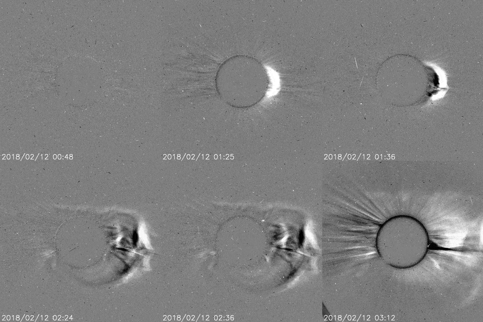
 On this Valentines day, our home star has blown us a kiss in the form of a Coronal Mass Ejection or CME for short.


 This big mass of solar energy was emitted on Monday, during a 6 hour long explosion. The blast of energy was ejected after a sunspot exploded causing the CME. It has been hurling towards the earth and should impact us late tonight or early Thursday morning.


The video clip is from a satellite that constantly observes the sun to detect just such explosions. You are looking at the sun through a special filter blocking out much of the visible light. You can see the clip goes from no activity to a huge eruption of energy. That is your classic CME. That's not all....That energy could tag team with a stream of solar wind  that was already making its way towards us. If they combine forces, the CME could hit the earth's magnetic field with an extra hard punch.

What does this mean for us?

Because we do have a protective shield that envelopes the planet, all the solar energy should be deflected and pushed towards the poles. As the energy dissipates, it forms the Northern Lights. They may be visible from the US-Canada border to points north.

That same CME blast could impact communication satellites, causing some interruptions in your cell phone services, Internet providers, and sat TV programming.


 The data and video clip courtesy of Spaceweather.com


Tuesday, January 30, 2018

Super Lunar Stuff

On Wednesday, January 31st, you will get a chance to see a Supermoon, a Blue Moon,  and a Lunar Eclipse all in one! The last time this happened was back in 1866.  Plenty to talk about so lets begin with what is  a "Supermoon".
  

Supermoon

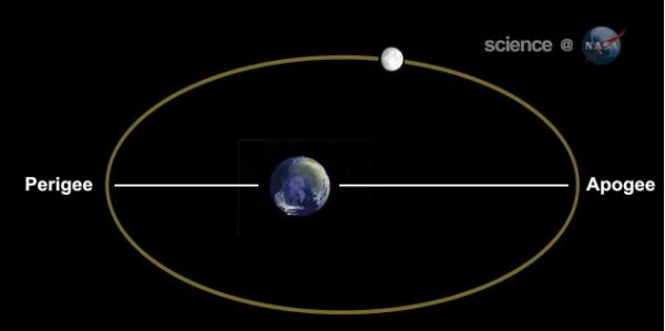
As the moon orbits the earth, it does so in an oval orbit, with it being at times a little farther away from earth (this is known as the Apogee) and sometimes closer (this is known as the Perigee). This Wednesday the moon will reach the Perigee at 4:54 am, being roughly 223 thousand miles way from the earth, as opposed to over 252 thousand miles when its at its farthest point.


This closeness makes it a "Supermoon". It will appear 14% larger and be 30% brighter than average. This will be the last of three such occurrences with the second taking place back at the start of January.

Blue Moon

Over the years, the second full moon of the month has come to be known as a blue moon. This "Supermoon" is also a full moon, the second of January which makes it a "Blue Moon". It won't really be blue as particles in the atmosphere will make it glow more orange than normal. Because of this, the event is also known as a "Blood Moon". Many are calling this lunar spectacle a Super Blood Moon!


 Lunar Eclipse

The earth will cast its shadow on the moon at the same time this is all happening creating a Lunar Eclipse.
Unfortunately, the eclipse will happen for us after sunrise and it will not be visible. This map courtesy of Spaceweather.


This is another map courtesy of Spaceweather, detailing the different areas that will have good visibility for the Eclipse.


For more details on all the Lunar Activity got to this NASA site:
NASA's Spermoon and Eclipse Site


Thursday, November 2, 2017

Why do we re-set our clocks?


We are all familiar with the saying, "spring forward, and fall back", which relates to setting the clock ahead one hour in spring and one back in the fall. But why do we do it? Here's a blog I wrote sometime ago explaining the tradition.


Here is a brief history of this practice:

18th Century:
Way back in the late 1700's Benjamin Franklin suggested that getting up earlier and enjoying the sunshine would help save lamp oil that otherwise would be wasted by staying up late at night.

19th Century:
When our country was young and most of the cargo was carried by train, companies needed set time zones so they would know where and when the goods would arrive. Time zones, splitting the nation into 4 parts, began in 1883. Until then, major cities set their own times from local astronomical observations.

20th Century:
By 1908, the House of Commons in England debated to change the time in order to eliminate "The Waste of Daylight". The measure failed.

Here in America, in 1918, congress passed a law making the time zones official for all to use but no time change was issued. That changed shortly thereafter as may countries engaged in World War I. The United States adopted Daylight Saving Time, pushing the clocks ahead one hour in order to conserve energy for the war effort. The measure was so unpopular that it was repealed as soon as the war was over.

As World War II emerged in 1944, we went back into Daylight Saving with clocks set ahead 1 hour. It remained this way until 1945. After the War, it was up to individual states whether to observe Daylight Saving.

In 1966 the Department of transportation was created and it took on the responsibility of handling the nation's time laws. They were confronted with a new problem... Television. How could networks tell the whole country at what time their favorite show would air if everyone was observing a different time zone? Over 100 million people were observing Daylight Saving set by local municipalities and customs, it was a mess.

Shortly thereafter, the Uniform Time act of 1966 was passed which called for the clocks to be set forward and backwards in the Spring and Fall. This new law just insisted that the states keep their times in a uniform fashion but did not force anyone to observe Daylight Saving.

21st Century
In 2007, new start and end dates were issued for Daylight Saving Time. It starts at 2 a.m. on the Second Sunday in March and lasts until 2 a.m.on the First Sunday of November.

As of last check, most states observe daylight saving time (DST), the exceptions being Arizona (except for the Navajo, who do observe daylight saving time on tribal lands), Hawaii, and the overseas territories of American Samoa, Guam, the Northern Mariana Islands, Puerto Rico, and the United States Virgin Islands.

Why do we still do it?
Proponents say, it saves energy.  We tend to use less electricity during the summer months because we are home fewer hours.  During this time of year, most Americans are enjoying outdoor activities. This means less electrical usage. This of course, if you live anywhere outside of Florida where we run our air conditioning units full max thru the summer months.

According to the U.S. Department of Transportation, a poll suggested that Americans liked Daylight Saving Time because "there is more light in the evenings / can do more in the evenings."  They also suggest, that while the amounts of electricity saved per household are small...added up they can be very large.