The eye of "Irma" may come too close for comfort in the Caribbean.
We start this first week of September, with all eyes fixed on powerful and compact Hurricane "Irma".
Headlines
- Hurricane watches remain in effect for Antigua, Barbuda,Anguilla, Montserrat, St. Kitts, Nevis, Saba, St. Eustatius, St Maarten, St. Martin, and St. Barthelemy.
- If nothing changes with the track, "Irma" should approach the Leeward Islands on Tuesday night/Wednesday morning
- It is forecast to stay as a major hurricane throughout the week.
- It may get even stronger over the next 2 days.
- NHC says, "Irma" may directly affect the Virgin Islands, Puerto Rico, Dominican Republic, the Turks & Caicos, and the Bahamas. For you in these areas, please monitor your local authorities for updated weather warnings.
- Watches & warnings may be issued for the Virgin Islands and Puerto Rico at any time through Monday.
- NHC says its still too early to tell if "Irma" may impact Florida or the rest of the U.S. Coastline.
- I will err on the side of caution and urge you in Florida to review your hurricane plans and supplies. Its always best to be ready before advisories are issued for South Florida.
Health
 "Irma" remains a compact but intense system.
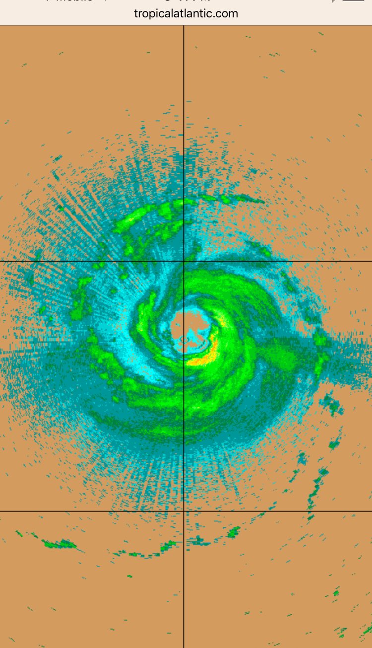
Even though the eye was not visible at times on satellite, an afternoon recon mission found it well formed with a healthy eyewall. This is the ring of destruction where the strongest winds and heaviest of the rainfall resides.
This is the radar image directly from the recon flight.
This is the radar image directly from the recon flight.
Hurricane force winds reach out from the center up to 35 miles while tropical storm force winds extend outward 140 miles.
There is really nothing significant ahead of it over the next 5 days to weaken it or deflect it.
It should remain on a mostly West/Southwest course throughout the next 48 hours then start a turn for the northwest after that.
Where is it headed?
The experts at the National Hurricane Center rely on models to give them an idea of where "Irma" may end up. The atmosphere is ever changing and so are the models. They vary from run to tun and can have huge forecast errors 5 - 7 days out. Sometimes as much as 240 miles in both directions. So focusing on a line is not the best course of action. These are used as a gauge and not a preset track.
These are the spaghetti models which show where the center, or eye, may be in the days ahead. Notice how tight they are by the Leeward Islands, this is a clear consensus of where "Irma" will be. They fan out however as they near the Bahamas, Florida, and the East Coast, with each line having a huge forecast error by day 5.

These are individual runs. The European says High Pressure will not budge, shown in the red shaded area, and puts a green blob (Irma) over South Florida by the 10th of September.

The GFS puts an extremely strong hurricane over the Bahamas and near South Florida also on the 10th.

NHC takes these and other models into account and issues their cone of concern. Everyone in the areas highlighted should be getting ready for the possible arrival of "Irma". Review your plans and supplies and for you in the islands you should complete your preps as soon as possible.

To give you a better idea of potential impacts, NHC has come up with a graphic that shows more or less the time when you may get Tropical Storm force winds, greater than 39 mph.


The Worry Meter:
Leeward Islands: HIGH. Complete your preparations. Hurricane watches are in place. Follow the advice of local authorities. Gusty winds may approach as early as Tuesday night.Virgin Islands, Puerto Rico, Dominican Republic, Haiti, Turks & Caicos Bahamas: ELEVATED. Review what you need and be ready for advisories to be issued soon. Keep a very close eye on the storm.
Florida & U.S. Coast: Moderate. Even though NHC says its too early to tell where it may end up, I would be checking my supplies and hurricane plan just in case. At worst we may be dealing with a hurricane in South Florida by the weekend, at best - this could just be a big scare.
I'll keep you posted.
No comments:
Post a Comment