
The higher cloud tops is where you will find the strongest storms.
The storms are trying to rotate counterclockwise and form a closed circle. When that happens, its a sure sign we have an organized system.
As of Saturday afternoon, a strong upper wind to the north was stopping that from happening.
NHC says: Regardless of development, heavy rains are likely over portions of Central America, the Yucatan Peninsula, Jamaica, Cayman Islands, and Western Cuba over the next few days.
Jamaica Advisories:
Flood advisories have been in effect for much of the country. They will probably be extended in some way through Sunday.- A Flash Flood Warning for low-lying and flood-prone areas of St. Mary, Portland, St. Thomas, Kingston and St. Andrew, St. Catherine, Clarendon, Manchester, Trelawny and St. Ann.
- A Flash Flood Watch for low-lying and flood-prone areas of St. Elizabeth, Westmoreland, Hanover and St. James., Clarendon, Manchester, Trelawny and St. Ann.

Forecast Models:
Model runs at this stage are very unreliable. They need a good starting point or a good spin, in order to forecast a track. Right now they are just providing an educated guess.
This is what the first few projections are showing. The black triangle forecast is a simplistic track... it shows, whichever way the low is moving now, is where it will continue to go.
But many things can influence a trajectory, fronts, upper winds, even other nearby lows.
Some of the other models here take that into account.
Formation Areas:
One reason why we are watching this low carefully is because of the area it is being born. System that are spawned here tend to, on average, move into the Gulf impacting areas from Mexico to Cuba and Florida.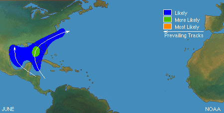 Hopefully nothing much comes from this and at most its just a good way to make sure you are ready in case something threatens South Florida. Stay tuned.
The figures show the zones of origin and tracks for different months during the hurricane season. These figures only depict average conditions. Hurricanes can originate in different locations and travel much different paths from the average. Nonetheless, having a sense of the general pattern can give you a better picture of the average hurricane season for your area.
fdgdfgdf
No comments:
Post a Comment