As we head into the work week of July 13...

Since the first of the year Miami has seen just over 16" of rain. The average is 27.68", that's deficit of almost 12 inches. For comparison, last year at this time we had accumulated 32.86"
For Ft. Lauderdale, since January 1st your rainfall has been just over 15 inches. What's typical is 30.05". You're almost 15" on the dry side. Last year at this time you were standing at 33.81".
We need to conserve water, there's just not enough to go around.
Key West is faring the best with just over 3/4" deficit since the start of the year.
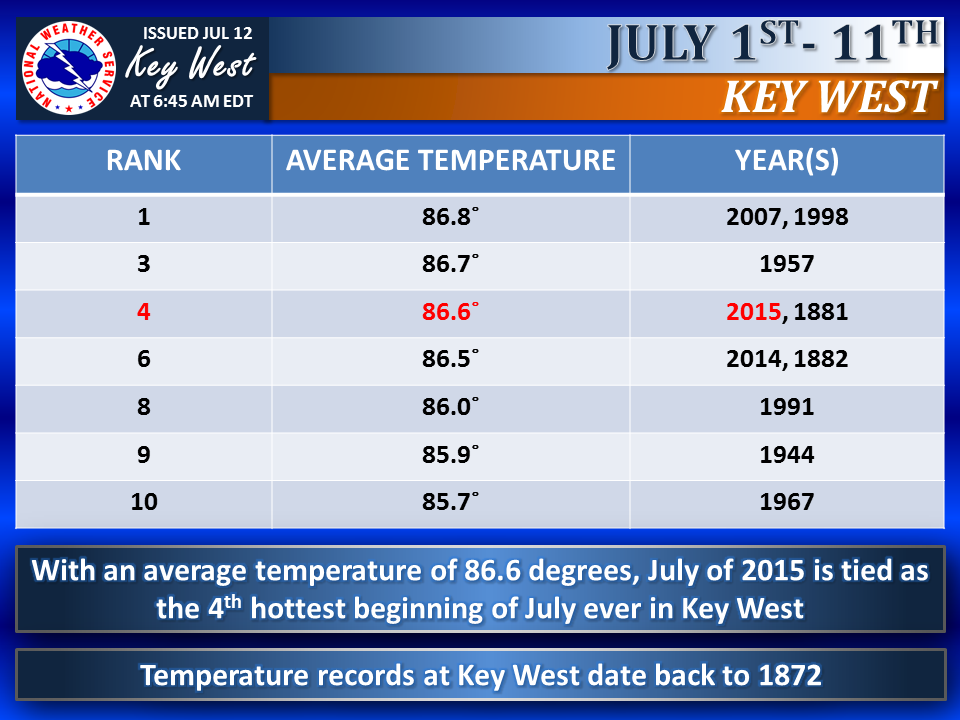
Its also been very hot in Key West. You are tied for fourth place for the hottest July start since records began for you in 1872. Check out this info provided by the Key West NWS office.
But things may change this week.
We've been dominated by a huge dome of high pressure, that extends from Louisiana and the Gulf, east through much of the Northern Atlantic (you can see the "H" on the map representing the high that goes all the way east into the open waters of the Atlantic).
There is also an "L" for low pressure off shore the Mid Atlantic states... we'll talk about that further down.
This high has provided the East Coast with a few showers, but driving all the heavy rain into Naples and SW Florida.

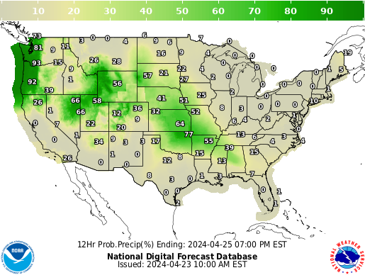
The long range models suggest the high may weaken and move east this week. This could open the door for much needed rain. The model graphic shown here suggests that we may see a better chance for rain starting on Tuesday (some models even hint by Monday) and sticking around through the end of the week.
In the Tropics:
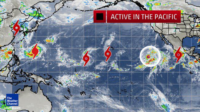
While the Atlantic basin has been quiet, you can't say the same for the Pacific. As of Sunday afternoon there were 5 systems, and possibly a 6th getting ready for development. (Image courtesy of the weather channel). This is due to some very warm waters. We are in an "El Nino" year, which heats up the Pacific waters adding fuel for tropical development. As a matter of fact, experts say that by July this present event will tie the "El Ninos" of 1982 and 1997 as the hottest on record with an almost 7F degree jump over normal temps.
At the same time, we get to see less activity during "EL Ninos", but that may change this week. There is an area in the Western Atlantic that NHC would like to investigate further.

This is what NHC is saying about it:
A non-tropical low pressure system located about 115 miles east of
Cape Hatteras, North Carolina, is producing disorganized cloudiness
and showers. Environmental conditions are expected to only be
marginally conducive for the development of a subtropical or
tropical cyclone during the next day or so while the low accelerates
northeastward away from the United States.
* Formation chance through 48 hours...low...20 percent
* Formation chance through 5 days...low...20 percent
This feature will not impact South Florida, although a weak wave or disturbance could be beneficial in helping to end our drought.
No comments:
Post a Comment