Monday, June 30, 2014

Possible Heavy rain from offshore Low

An area of low pressure that we've been monitoring since last week remains ready to become the season's first depression, but as of this writing it has not. You can clearly see a surface counter clockwise spin, yet strong upper winds are pushing most of the rain directly south.

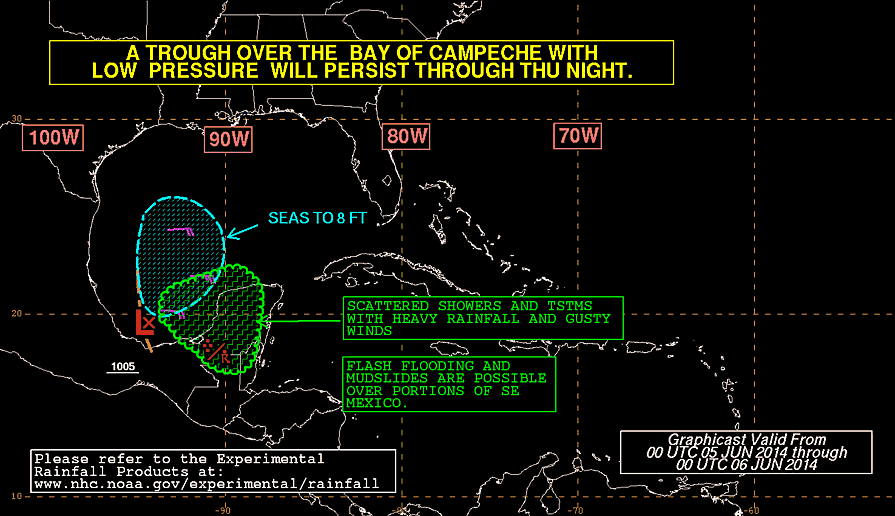
The color enhanced blotches in reds, golds, and oranges represent the heaviest rain. As long as this low remains to our east, South Florida and the NW Bahamas will have to deal with some tropical downpours.

Latest from NHC:

  • Shower and thunderstorm activity remains minimal in association with a low pressure area located about 140 miles east-northeast of Melbourne, Florida.  However, surface pressures are falling, and environmental conditions are forecast to become more conducive for development during the next few days.  
  • A tropical depression is likely to form by mid-week while the system moves slowly southwestward and then turns northward and northeastward near the southeastern United States coast.  
  • An Air Force Reserve reconnaissance aircraft is scheduled to investigate the low this afternoon, if necessary.
  • Formation chance through 48 hours...high...60 percent.
  • Formation chance through 5 days...high...80 percent.


What are the models suggesting?

They have remained pretty much in agreement that by midweek, just when NHC thinks it may become a depression, the low will get pushed north aiming for the Barrier Islands, and then turning more northeast.

Until that happens we will have to deal with the potential for heavy rain.


Local NWS office:

Since the potential for heavy rain is there for South Florida and NW Bahamas, they expect the possibility of street flooding. The timing is from early afternoon through Tuesday.  They suggest Palm Beach County could be the wettest over that time frame for South Florida.


On the rainfall forecast graphic, you can see possible rainfall totals between half an inch to over an inch for South Florida with Grand Bahama Island forecast at around two inches over the next 24 hours.

We'll keep you posted if anything changes.


Sunday, June 29, 2014

NHC expects depression to form East of Florida

Recon mission set for Monday, if needed to investigate off shore low.

As we begin to lose some of the satellite detail to darkness, you can still make out the distinct swirl of a tropical low.  Not much has changed since early Sunday morning as it is still meandering over the warm waters of the Gulf Stream. As you know, warm waters of 80 degrees or above is like jet fuel to these tropical engines and there is plenty to be found here.

This low could become the season's first depression or maybe even the first tropical storm. If it does reach tropical storm status. it would be named, "Arthur".


NHC update as of 8pm Sunday night:

  • An Air Force Reserve reconnaissance aircraft is scheduled to investigate the disturbance on Monday, if necessary.
  • Showers and thunderstorms associated with a low pressure area located about 230 miles east of St. Augustine, Florida, remain limited.  
  • Environmental conditions are forecast to become more conducive for development during the next few days and a tropical depression is likely to form by mid-week while the system moves slowly southward to southwestward off the east-central coast of Florida.  
  • Formation chance through 48 hours...high...60 percent.
  • Formation chance through 5 days...high...80 percent.


This is what the local NWS office is saying:

  • LOW PRESSURE IS DRIFTING TOWARDS SOUTH FLORIDA, AND WILL CONTINUE TO DO SO OVER THE NEXT FEW DAYS. 
  • THIS WILL KEEP INSTABILITY AND MOISTURE OVER THE AREA AS WELL AS THE HIGHER CHANCES FOR CONVECTIVE ACTIVITY EACH DAY. 

This basically means that while the low remains offshore, we can expect  healthy chance for rain through mid to end of next week.

Computer forecasts (Models)
This low is still INVEST91, or an area of disturbed weather NHC would like to INVESTigate further. At this stage early model runs are initiated and are shown on the spaghetti chart. Keep in mind models do not perform well at this stage because of lack of something definitive to track. As of this moment, most keep whatever develops away from South Florida. That doesn't mean we will not feel some of its effects.

I have provided 2 different spaghetti model charts for comparison. As of this moment, most runs keep the low close until midweek and then push it out to sea due to strong upper level winds.


What can we expect?:

It appears we should see more in the way of cloud cover, with a better chance for rain as some of the moisture associated from the low gets spun out in our direction.


NHC keeping tabs on a Low

Chances for development continue to grow with area of low pressure East of Jacksonville

On the satellite imagery you can see the swirl sitting just offshore. For the time being it has most of the rain over the Atlantic waters , but in the long run some of those showers and storms will make it onshore.  Wherever you see bright blues and reds, that represents the strongest downpours.

As of Sunday Morning, this is what NHC was saying:

  • A low pressure system located about 230miles east of Jacksonville, Florida, continues to produce disorganized showers and thunderstorms as it moves slowly southward. 
  • Upper-level winds are only marginally favorable, and proximity to dry air to the north of the disturbance could inhibit formation of a tropical  cyclone over the next couple of days.  
  • By Wednesday, however, environmental  conditions are expected to become more conducive for development of this  system while it drifts southward and  meanders offshore of the Florida east coast.  
  • An Air Force Reserve Hurricane Hunter aircraft is scheduled to investigate this system this afternoon, if necessary.
  • Formation chance through 48 hours...medium...40 percent.
  • Formation chance through 5 days...high...70 percent.
What next?:

This tropical feature will drift South over the next few days maybe getting as close a couple of hundred miles to the East of Central Florida by Monday or Tuesday. This may be its best chance for organization as it will be sitting over the warm waters of the Gulf Stream. As you know, hot water is like jet fuel for these tropical engines, the hotter, the more energy for intensification.

In the long run, the models suggest strong upper winds will begin to push this area of disturbed weather away from us and into the Northeastern Atlantic.

NHC has deemed this low as INVEST 91. It just means they would like INVESTigate the area a little more and can devote more resources. Once this happens, some early model runs are released and they are reflected in the spaghetti model graphic.

Keep in mind all the models have a very difficult time at this stage of the game since they have very little information to work with.


What can we expect:

High pressure will build in the Gulf of Mexico by Sunday, causing a wind squeeze over Florida.  High pressure has clockwise winds while the low has counter clockwise winds. We will be in the middle of this pressure gradient so expect breezy conditions by early next week.  Clouds will also be on the increase with a better chance for rain.

Wednesday, June 25, 2014

Space Lightning

They are known as "Sprites", and its basically lightning that comes out of the top of a thunderstorm and heads into space.  We are very accustomed to the typical cloud to ground lightning, but with the start of summer, there is plenty of thunderstorm activity, and some of these storms are showcasing, "Sprites". 

It doesn't end there, an avid observer has taken pictures of what he calls "Jellyfish Sprites".  "Lately there has been a bumper crop of sprites," explains Thomas Ashcraft, a longtime observer. "Here is one of the largest' 'jellyfish' sprites I have captured in the last four years."  

This diagram depicts where in the atmosphere, "Sprites", can be found.  

A commercial jet can fly around 8 miles high or around 15 kilometers.  This is still within the Troposphere where most of our weather takes place. 

You still have to travel over three times the distance to see this display.

The following "Sprite" outbreak was captured on June 23rd, from western Oklahoma. Observers say it was such a big show it was captured by Ashcraft as far away as New Mexico, some 289 miles away. Click on the link below for the images. (I like the audio crackle picked up from the energy charge in the atmosphere)
  

The video shows the "Sprites" taken at different speeds. The last take is the most impressive.
Ashcraft says these "Jellyfish Sprites" were 40 miles tall and 46 miles wide dwarfing Mt. Everest!

"Sprites" were discovered by pictures taken from the Space Shuttle back in 1989. They are a unique space phenomenon that demands plenty of study.

So the next time you are talking lightning, you can impress your friends with a "Sprite"!
((Mr.Ashcraft's interview and images courtesy of Spaceweather.com))

Friday, June 6, 2014

High Chance for Depression in Gulf

Since the start of the week we've been following an area of disturbed weather in the SW Gulf of Mexico. It has teetered between a 10 - 20% chance of development through much of that time, but yesterday it started getting its act together.

Late Thursday night NHC upped its chances to 30% and then 40%.

Friday morning things got a bit more complicated.  Chances for development now stand at 70%.

The satellite loop shows 2 colors.

Notice the yellow enhanced clouds, those are near the surface and its where you will find the actual low. It is moving west to Mexico.

The white enhanced clouds are moving in the opposite direction pushed along by strong upper level winds. Typically these winds help to keep systems in check but in this case its not happening.

Heavy rains continue to pound Coastal Mexico.

This Radar out of the Yucatan shows a steady band of rain that has been sitting here for days.

Even if this low doesn't develop,  it will not be good news for the Yucatan Peninsula.

They are soaked from a recent Tropical Storm earlier this week that moved in from the Pacific Ocean (Boris).

This new possible depression could add to the misery as it is slowly forecast to move West.


Here's NHC's early note:

Satellite imagery and surface observations indicate that the
area of low pressure about 40 miles east of Veracruz, Mexico, has
become a little better defined this morning as it moves slowly
west-northwestward.  However, the associated thunderstorm activity
is currently poorly organized.  A tropical depression could form
before the low reaches the coast of eastern Mexico later today or
tonight. An Air Force Reserve reconnaissance aircraft is scheduled
to investigate this system this afternoon. Whether a tropical
depression forms or not, this disturbance could produce heavy rains,
along with life-threatening flash floods and mud slides, over
portions of southeastern and eastern Mexico during the next few
days.

  • Formation chance through 48 hours...medium...70 percent
  • Formation chance through 5 days...medium...70 percent.


Indeed a recon plane will be sent this afternoon to see if there is a closed center of circulation, how strong the winds are, and what other features may be surrounding the low.

If certain parameters are met, we could have our first depression (or even first Tropical Storm) of the Atlantic season.


Here are the latest models:


What does this mean for us?:
Nothing. We will remain in our typical rainy season pattern with sun, heat, humidity, and afternoon storms through the weekend.

Thursday, June 5, 2014

Good and Not so Good

Good:
Finally sunny skies return to most of South Florida. We should remain mostly sunny with only a slight chance of showers through the weekend.

Not so Good: (Specially for the folks in Coastal Mexico)
In the tropics, NHC is keeping tabs on an area of disturbed weather in the SW Gulf of Mexico. This is the same area that's been causing heavy rain over the region for days.  Its chances for development have been hovering between 0 and 20% since Monday.


On Thursday, NHC upped the chances for development: Here is their early statement:

Showers and thunderstorms have recently increased near a low pressure area over the southern Bay of Campeche.  Despite strong upper-level winds, some further development of this system is possible over the next day or two if the low remains offshore of eastern Mexico.

An Air Force Reserve Hurricane Hunter aircraft is
scheduled to investigate this system this afternoon, if necessary.

This disturbance has the potential to produce extremely heavy rains and life-threatening flash floods and mud slides over portions of southeastern Mexico during the next few days.


* Formation chance through 48 hours...medium...30 percent.
* Formation chance through 5 days...medium...30 percent.

For the moment it will be a nuisance for shipping interests as well as being a huge rainmaker for the region.

Seas will be very rough around the Bay of Campeche and Central Gulf of Mexico as long as this disturbance is around.

Even if this feature doesn't get any stronger, heavy rain will come down over the Yucatan Peninsula. This will lead to flood and possible land and mudslides.

Whats's Next:
Now that it appears there is more thunderstorm activity despite strong upper level winds… what is in its future?

Its not an easy nor simple answer.  We look for computer model guidance and even here the results are not conclusive:

The local NWS office is focusing on two solutions. This what they are saying:

THE GFS STILL MAINTAINS AN AREA OF LOW PRESSURE ACROSS THE BAY OF
CAMPECHE PUSHING NORTHEAST...EVENTUALLY MAKING IT TO SOUTH
FLORIDA THROUGH THE LATTER HALF OF NEXT WEEK. 

THE ECMWF ON THE OTHER HAND HAS HAD BETTER RUN TO RUN CONSISTENCIES KEEPING THIS LOW ACROSS THE BAY OF CAMPECHE. 

AS A RESULT...PLACED MUCH MORE WEIGHT WITH THE ECMWF SOLUTION DURING THIS TIME FRAME IN THE OFFICIAL FORECAST.


The outlook of most models keep whatever develops in the Western Gulf of Mexico


What does this mean for us?
For the moment, nothing. Enjoy the upcoming weekend and celebrate with the grads. We should see our typical rainy season pattern with heat, humidity, and a chance for afternoon thunderstorms.

Worry level: Low.
Since nothing has really developed yet, and it appears that it will be staying over the SW Gulf for a few days, all we can do is keep looking West and see what it decides to do. As always keep checking for the latest tropical outlook.

Wednesday, June 4, 2014

Status Quo

This midweek brings us to midway in a developing process.  Could we be seeing the first real tropical activity of the season brewing in the Gulf?

We have two areas to watch.  A disturbance in the Gulf and Tropical Depression Boris in the Pacific side of Mexico.

Here's the latest on the Gulf disturbance from NHC:

A stationary trough of low pressure over the Bay of Campeche is
producing disorganized showers and thunderstorms.  Strong
upper-level winds will likely inhibit significant development of
this system.  However, this disturbance has the potential to
produce locally heavy rains during the next few days over
portions of southeastern Mexico.
* Formation chance through 48 hours...low...10 percent
* Formation chance through 5 days...low...20 percent


For us this just means mostly cloudy skies with a feds showers everyday through the end of the week. By then we may see some of that moisture getting pushed here.

Meanwhile, there is Boris, getting weaker and dumping plenty of rain over Southern Mexico. It's trying to cut across into the Gulf. If it can make it this would be the first time since Cosme did it in 1989. That was the last system to go from the Pacific to the Atlantic Basin.

Even if it falls apart, there is a chance for it to reform in the warm waters of the Gulf. We'll be watching.  So here we are in the middle of a process that only Mother Nature knows the game plan.


Tuesday, June 3, 2014

From soggy to soggier?

We've been caught in the middle of a weak frontal boundary to our east and an upper low to our west.
While typically high pressure is your fair weather friend, this time its trapping moisture over us and keeping us damp.

Rain totals across Mainland South Florida on Monday ranged between half an inch at MIA, to almost 3 inches at North Perry Airport.

The clouds and the moisture will remain across the area for much of today with most of the downpours in the Keys

Heavy rain continues there, as of this writing, Marathon has received about one inch of rain.

Breezy conditions at the beach will keep the threat of rip currents constant at the beach

As far as the tropics are concerned, the area of disturbed weather (surface trough) in the Gulf is still there but dormant if you will. It may start to get its act together on Wednesday, if it does it could keep us gray and damp through next week.  This wet outlook is not set in stone but it is a possibility.

This is from NHC's Tropical Discussion:

A LOW  PRESSURE CENTER IS FORECAST TO DEVELOP OVER THE SW GULF ON WED 
MORNING ASSOCIATED WITH THE CURRENT SURFACE TROUGH. RAIN SHOWERS 
ARE EXPECTED TO CONTINUE OVER THE SW AND NE GULF THROUGH THU 
MORNING.

The local weather office is also looking into it and for the time being they will be monitoring the situation as well.

The say the models are still not clear on what will happen. They use as an example the widely different offerings provided by the GFS and ECMWF models.

THE GFS BRINGS THIS LOW ACROSS THE YUCATAN PENINSULA AND INTO THE SOUTHEASTERN GULF OF MEXICO INTO EARLY NEXT WEEK. THIS REMAINS THE MORE AGGRESSIVE AND MUCH WETTER SOLUTION BRINGING HEAVY RAINS ACROSS SOUTH FLORIDA THROUGH THE FIRST HALF OF NEXT WEEK. 

THE ECMWF STILL HOLDS ON TO A DRIER SOLUTION KEEPING
THE LOW NEARLY STATIONARY IN THE BAY OF CAMPECHE THUS ALLOWING
HIGH PRESSURE ACROSS THE WESTERN ATLANTIC TO KEEP THE DEEPER
MOISTURE SURGE AWAY FROM SOUTH FLORIDA. TRENDED THE EXTENDED
PERIOD MORE TOWARD THE ECMWF MAINLY DUE TO BETTER RUN TO RUN
CONSISTENCIES. HOWEVER...UNTIL BETTER MODEL AGREEMENT
EXISTS...CONFIDENCE REMAINS LOW IN THIS PORTION OF THE FORECAST.

For the time being all we can do is wait and keep our rain gear handy.

Meanwhile lets add another interesting twist.
A new Tropical Depression sprouted on Monday in the Eastern Pacific just south of Mexico. It is a very weak system with only 35 mph winds, but it will be a rain making machine. Some forecasts are calling for anywhere between 20-30 inches of rain!

This is the latest NHC statement:

RAINFALL...GIVEN ITS SLOW NORTHWARD PROGRESSION...TROPICAL
DEPRESSION TWO-E IS EXPECTED TO PRODUCE AS MUCH AS 10 TO 20 INCHES
OF RAIN OVER A LARGE PART OF SOUTHERN MEXICO THROUGH SATURDAY...WITH
ISOLATED AMOUNTS EXCEEDING 30 INCHES LIKELY OVER THE MOUNTAINOUS
TERRAIN OF THE MEXICAN STATES OF OAXACA AND CHIAPAS. 

TROPICAL DEPRESSION TWO-E IS ALSO EXPECTED TO PRODUCE TOTAL RAINFALL AMOUNTS OF 5 TO 10 INCHES IN GUATEMALA. THESE RAINS ARE LIKELY TO RESULT IN
LIFE-THREATENING FLASH FLOODS AND MUD SLIDES.

This system is forecast to move over the narrowest part of Mexico and could eventually enter into the Gulf

If this does happen it will be interesting. Tropical systems that cross from the Pacific into the Atlantic basin are rare. If it does happen will it keep its name?

This is from NHC:
If the system remains a tropical cyclone as it moves across Central America, then it will keep the original name.

Only if the tropical cyclone dissipates with just a tropical disturbance remaining, will the hurricane warning center give the system a new name assuming it becomes a tropical cyclone once again in its new basin.

The rule used to be that if the tropical storm or hurricane moved into a different basin, then it was renamed to whatever name was next on the list for the area. The last time that this occurred was in July 1996 when Atlantic basin Tropical Storm Cesar moved across Central America and was renamed Northeast Pacific basin Tropical Storm Douglas. The last time that a Northeast Pacific system moved into the Atlantic basin was in June 1989 when Cosme became Allison.

There is also a chance that some of that rain could also make its way to Florida in the long run.  It will get interesting in the days ahead. Stay tuned.

Monday, June 2, 2014

Tropical Update: Watching rain in Gulf

NHC is still monitoring an area of disturbed weather in the Gulf of Mexico.   From the satellite imagery you can see plenty of clouds and rain moving out of the Yucatan Peninsula and aiming for Florida.

What one looks for in this enhanced color imagery, is where you find the oranges and reds.

These colors represent the heaviest of the rainfall.  All this rain is still to the east of a stretched out area of low pressure extending from Louisiana south to Mexico.

Very little movement is expected from this feature over the next few days.


This is what NHC says: (As of 8 AM)

A stationary trough of low pressure interacting with a large upper-level low is producing widespread cloudiness and disorganized showers over much of eastern half of the Gulf of Mexico and across
the Yucatan Peninsula. 

Environmental conditions are expected to remain unfavorable for the development of this system as it moves little this week.

  • Formation chance through 48 hours...low...near 0 percent
  • Formation chance through 5 days...low...10 percent


While on Sunday, models were hinting at more favorable conditions for storm formation over the next 5 days… now they are backing off and suggesting the present poor conditions will remain through the end of the week.  As long as that Upper Low remains over the trough it should help keep it in check. This is very good news.

But what about the rain?
To determine that, we use another color scheme on our satellite picture. This is the water vapor loop. It detects moisture in the mid to upper levels of the atmosphere.


The colors we look for are the light blues which represent possible light rain, to the deeper oranges, reds, and purples, which tell us there is plenty of moisture capable of tropical downpours.

This means our chances for rain will be going up as some of that moisture gets kicked out in our direction.

This may be the pattern throughout the entire week.


Worry Factor: Extremely low
One word of caution. These disorganized features tend to grow rather quickly specially moving over very warm waters.  Check back in tomorrow just in case the models change their minds.

Sunday, June 1, 2014

1st Day of Hurricane Season, Something in the Gulf

As I mentioned on Saturday, there is an area of disturbed weather in the Gulf of Mexico, that could eventually impact Florida or the Gulf States.

The satellite imagery shows plenty of cloud cover extending from the Yucatan Peninsula , through Western Cuba, and almost reaching Western Florida.

The darker oranges and red colors on the sat pic illustrate the heavier rains.  For the time being this is all that is present within this weak area of low pressure.

At times you may be able to see a small spin in the middle of the Gulf.  This is what we will be watching for as far as development s concerned.

At the moment the pressure readings are pretty high (good) and the western side of that spin is cloud free (good).

If the pressure were to start dropping and the rain bands close off and surround the middle of the spin, then it would be a sign of organization.

So, today on the first day of hurricane season, NHC has issued their first formation potential graph on this area.


This is what they say:

An elongated and nearly stationary area of low pressure located over the Bay of Campeche extends northeastward into the south-central
Gulf of Mexico.

Although shower activity is currently disorganized, some slow development of this disturbance is possible this week as
environmental conditions become marginally conducive.

Chances for growth from NHC

  • Formation chance through 48 hours...low...near 0 percent
  • Formation chance through 5 days...low...20 percent

So what are those environmental conditions?
The recipe for a hurricane includes many ingredients. In this case the most important ones are: Water temps of 80 degrees or above and no strong upper winds to cut it the low down.

Lets check on the water temps:

The area of low pressure is sitting over waters with a reading between 27 and 28 degrees Celsius which is right at 80 degrees Fahrenheit or slightly above.  So at least here there is enough energy for it to grow. Warm waters are like jet fuel for these tropical entities… the warmer, the better for intensification.

Lets check whats happening directly above this feature:

The first thing we look for is the jet stream. This is a river of air in the upper levels of the atmosphere so strong, it cuts down the cloud tops of tropical systems and helps keep them in check.

Sunday through Monday, the jet remains well to our north.

This doesn't mean the low has an open door for growth,  it just means the jet will not be a big player in keeping the area of disturbed weather down.

The jet stream forecast will not change much
over the next 3-5 days.


So where is the low headed?
If we look at the map. the dashed line in the Gulf represents where the possible center of this weak low is situated.

Now look at the long lines also cutting diagonally across the Gulf, this is a huge dome of high pressure. This is like a big wall preventing the disturbance from moving east (for the moment).

It may take a few days for this road block to move east and allow the low to start making a move.  Where it will end up is still unclear.

I will wait for later model runs to determine that.

South Florida Worry Factor:  Low
As of this writing, what we may see is a better chance for rain as the associated moisture gets spun out in our direction.  Even if something were to develop, it may take 5 days for that to happen.  We'll stay on top of it.  Check back tomorrow for an update.